mariuscomper.uk RO
1877

Upper Engadine, Switzerland · 1877–2025

The Morteratsch Glacier on every Swiss map since 1877

Swiss surveyors have mapped this glacier again and again since 1877, and measured its front almost every autumn since 1878. Here are 18 editions of the national map and a 2025 aerial photograph, laid over the mountain as it stands today, with the measurements beneath them.

Drag the mountain to turn it

1877

The first precise map

On the Siegfried map in print in 1877, the Bernina sheet of that year with the St. Moritz sheet of 1875 to the north, the ice fills the valley floor below Piz Bernina, at 4,049 m the highest summit of the Eastern Alps, and its tongue reaches down into the larch forest.

Every map here lies on the ground as it is today, so the old ice is drawn on a valley floor that in 1877 lay beneath it.

The ice front was a place people walked up to.
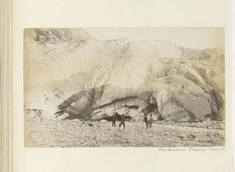
Four people in dark clothes stand on stones in front of a high wall of glacier ice with a dark cave at its foot.
Four walkers at the ice front of the Morteratsch Glacier. Photograph, about 1860–1890. Rijksmuseum, Amsterdam, CC0.
Since autumn 1878

Measured almost every autumn

In the autumn of 1878 the position of the glacier’s front was measured for the first time. Since then it has been measured again almost every year. The record is kept by GLAMOS, the Swiss glacier monitoring network: 137 measurements, with one year, 1893–94, missing.

3,059 mmeasured retreat of the front, from autumn 1878 to October 2024
1887 – 1938

The old maps lag behind the ice

The Bernina sheet was reprinted in 1887, 1896, 1909, 1925 and 1938; the St. Moritz sheet, which holds the end of the tongue, in 1896, 1908, 1925 and 1938. In 1887 the end of the tongue was still on the 1875 sheet, and on the 1909 and 1938 editions it looks as it did on the editions before. Press the play button to step through them.

Over those sixty years, from 1878 to 1938, the measured front retreated 683 m.

1950 – 1971

A new map, and the fastest retreat of the 20th century

From 1950 the new national map replaced the Siegfried sheets, at 1:50,000, then at 1:25,000: the St. Moritz sheet from 1958 and the Piz Bernina sheet from 1964. The style of drawing changes with it: the blue contour lines on the ice are a new way of drawing it, not new ice.

The front retreated 261 m in the 1940s, 282 m in the 1950s and 318 m in the 1960s, more in each decade than in any decade before.

1970s – 1980s

A pause

Then the retreat slowed: 141 m in the 1970s, 85 m in the 1980s. In 1985 and 1988 the front was even found a few metres further down the valley than a year before, 8 m and 2 m.

Small advances like these were also measured in 1899, 1912 and 2004. None of them lasted.

1990 – 2024

The fastest decade on record

In the 2010s the front retreated 606 m, nearly twice as much as in any decade before. The two largest retreats in a single year were measured in 2015, 164 m, and 2016, 135 m.

On the 2015 edition the tongue has pulled far back up the valley, and the stream runs where the ice was.

2025

Today, with the ice of 1850

This is the aerial photograph swisstopo took in 2025. The white line is the glacier around 1850, at the end of the Little Ice Age, reconstructed from old maps and from the moraines the ice left behind. Then the ice ended less than half a kilometre from Morteratsch.

In 2025 the tongue was already free of snow in June. Across Switzerland, glaciers lost more than 5% of their volume in 2026, and nearly a fifth in five years.

How far has the front retreated since the year you were born?

Type a year: the year you were born, or a year you stood in this valley. The sum runs from that autumn to the last measurement, in October 2024, and the mountain shows the map published closest to it.
How much has the Morteratsch Glacier retreated?

3,059 m from autumn 1878 to October 2024, in 137 measurements. Every bar below is one of them; bars above the line are the few years the front moved forward. The figure for 2020–24 covers five measurements, not a full decade.

0-50-100-1500-1,000-2,000-3,000m a yeartotal since 187818801900192019401960198020002020

Measured change of the front each year (bars, upper scale) and the running total since 1878 (line, lower scale).

Retreat of the front by decade

  • 1880s −181 m
  • 1890s −129 m
  • 1900s −94 m
  • 1910s −67 m
  • 1920s −96 m
  • 1930s −150 m
  • 1940s −261 m
  • 1950s −282 m
  • 1960s −318 m
  • 1970s −141 m
  • 1980s −85 m
  • 1990s −165 m
  • 2000s −294 m
  • 2010s −606 m
  • 2020–24 −189 m

Each measurement is counted in the decade in which it ended.

Why no line marks each year’s front

The obvious picture would be a mark on the valley for every year: here the ice ended in 1878, here in 1950, here in 1984. Before drawing it, a rule was written down for checking it. Start from the glacier’s outline in 2015, step back down the valley by the measured changes, and the marks must land within 100 m, or within a tenth of the distance travelled, of the fronts on the outlines of 1935, 1973 and 2010.

They did not. The 1935 front landed 156 m off, which passes; 1973 was 309 m off and 2010 405 m off. A likely reason: the outlines keep the debris-covered ice near the snout, which the people measuring on the ground may no longer count as the glacier’s front, and the gap grew as the tongue broke up. So the page shows each map as the surveyors drew it, and the measured numbers, and no yearly marks.

The valley in photographs

Three views from the valley floor, each from a different spot.

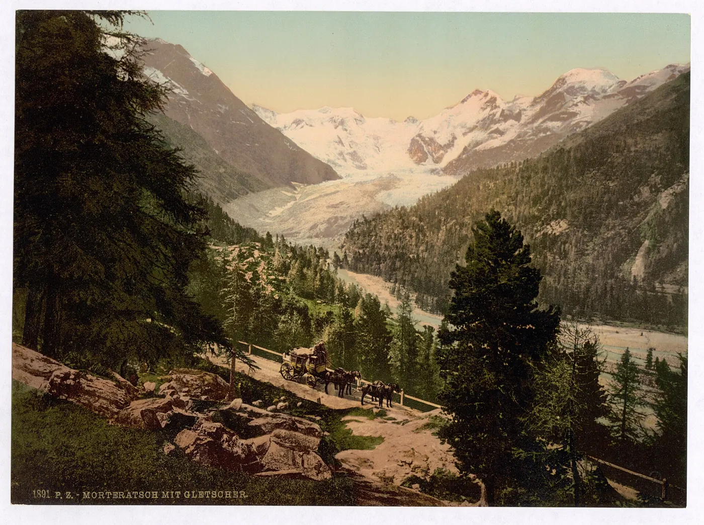
A coloured print of a mountain valley: a long white glacier comes down between dark slopes towards a forest, under snowy peaks.
Morteratsch with the glacier. Photochrom print, 1890–1900. Library of Congress, Photochrom Print Collection, public domain.
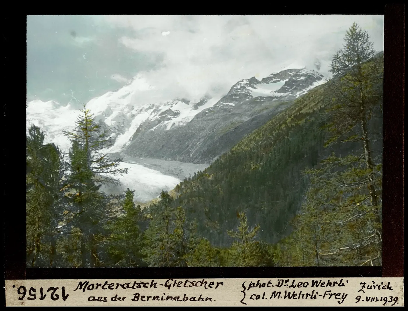
A hand-coloured glass slide: a grey glacier tongue in a valley, larch trees in front, clouds over the peaks; a handwritten label below.
The glacier seen from the Bernina railway, 9 August 1939. Photograph by Leo Wehrli, slide coloured by Margrit Wehrli-Frey. ETH-Bibliothek Zürich, Bildarchiv, CC BY-SA 4.0.
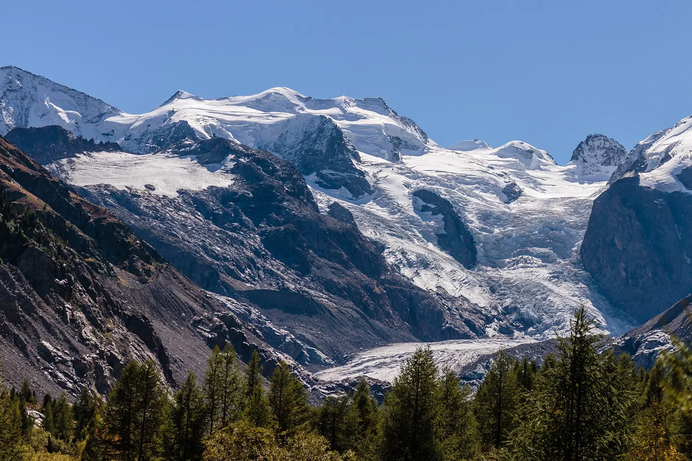
A sunny view of snowy peaks with a short, grey glacier tongue far back between bare rock slopes, larch forest in front.
The glacier from the trail, 22 September 2026. Photograph by Dominicus Johannes Bergsma, CC BY-SA 4.0.

Where does the water go?

The meltwater runs out of the glacier as the Ova da Morteratsch, which joins the Ova da Bernina below Morteratsch. Just below Pontresina the Ova da Bernina meets the Ova da Roseg; together they are the Flaz, which flows into the Inn near Samedan. The Inn leaves Switzerland, crosses Austria and reaches the Danube at Passau, in Germany. From there the water passes Vienna, Budapest and Belgrade and reaches the Black Sea through the Danube Delta, in Romania.

By then it is a tiny share of the river. The ice that melts here, though, is part of the Danube’s summer flow.

Sources and method

The length changes are the GLAMOS series for Vadret da Morteratsch: 137 measurements of the front, from 1 September 1878 to 17 October 2024. Their sum is −3,058.8 m. One year, 1893–94, has no measurement. Six intervals span two or three years; for a year inside one of them, the change is split in proportion to the days. The dates of many older measurements are approximate.

Each map is a swisstopo “Journey through time” edition, the sheet in print at the end of the named year, reprojected from Web Mercator tiles onto the Swiss LV95 grid and laid over swissALTI3D at 20 m spacing, with the terrain at true height. The year shown is the year the sheet was published; the ice on it was surveyed earlier, often a year or more. North of 1,146 km the scene uses the neighbouring sheet (St. Moritz), which was revised in other years. In 1887 the end of the tongue is still on the 1875 St. Moritz sheet, and three editions (1909, 1938, 2009) show the tongue unchanged from the editions before, judged by eye; the label says so.

The test of drawing yearly fronts on the valley was written down before it was run; its rule, the result and the code are kept with the project. The 1850 outline is the Swiss Glacier Inventory 1850, reconstructed from historical maps and moraines.

GLAMOS publishes its data under CC BY 4.0 on the DOI record, while the file and website ask for scientific and non-commercial use. This page is non-commercial. swisstopo geodata are free to use with the source named.

Sources

  1. GLAMOS – Glacier Monitoring Switzerland (2025). Swiss Glacier Length Change, release 2025. doi:10.18750/lengthchange.2025.r2025 (series E22-03, Vadret da Morteratsch, 1878–2024). Licence: CC BY 4.0 on the DOI record; the file itself asks for scientific and non-commercial use. link
  2. GLAMOS. Swiss Glacier Inventories 1850, 1931, 1973, 2010 and 2016 (glacier outlines). Maisch et al. 2000; Mannerfelt et al. 2022, The Cryosphere 16: 3249–3268; Müller et al. 1976; Fischer et al. 2014; Linsbauer et al. 2021. link
  3. swisstopo. Journey through time: Siegfried map 1:50,000, sheets 521 Bernina and 518 St. Moritz (1875–1938); National map 1:50,000, sheet 268 Julierpass (1950–1959); National map 1:25,000, sheets 1277 Piz Bernina and 1257 St. Moritz (1958–2015). © swisstopo. link
  4. swisstopo. SWISSIMAGE 10 cm aerial photographs, 2025 flight over the Bernina area; swissALTI3D terrain model, 2 m (2023). © swisstopo. Copernicus DEM GLO-30 (ESA) fills the Italian side of the scene. link
  5. GLAMOS (2026). Swiss Glacier Bulletin 2025: 3.0% (1.4 km³) of Swiss glacier volume lost in 2025; the Morteratsch tongue already free of snow in June 2025. doi:10.18752/glbulletin_2025. link
  6. ETH Zurich (1 October 2026). Devastating year for Switzerland’s glaciers: more than 5 per cent of the volume lost in 2026, nearly 20 per cent in five years. link
  7. Swiss Alpine Club route portal: Piz Bernina (4,049 m), the only four-thousander of the Eastern Alps. link
  8. swisstopo VECTOR25 water network (Ova da Morteratsch, Ova da Bernina, Ova da Roseg, Flaz); Gemeinde Pontresina, report on the mountain rivers flowing via the Ova da Bernina and the Flaz into the Inn. link
  9. Linsbauer et al. (2021). The New Swiss Glacier Inventory SGI2016. Frontiers in Earth Science 9: 704189 (river code E = Inn). link
  10. Photographs (Wikimedia Commons): Photochrom Print Collection, Library of Congress, “Upper Engadine, Morteratsch Glacier”, 1890–1900, public domain; Rijksmuseum RP-F-F00997-Z, ca. 1860–1890, CC0; Leo Wehrli, slide coloured by Margrit Wehrli-Frey, 9 August 1939, ETH-Bibliothek Zürich, Bildarchiv, CC BY-SA 4.0; Dominicus Johannes Bergsma, 22 September 2026, CC BY-SA 4.0. link

mariuscomper.uk · Maps, aerial photograph and terrain: © swisstopo · Glacier data: GLAMOS