LONDON · THE FLEET · LOST RIVERS
Where exactly is the river under this street?
A river runs under Fleet Street. This page walks you down it, then buries it in front of you.
From Hampstead’s ponds to Blackfriars Bridge, the Fleet falls four miles through Kentish Town, King’s Cross, Clerkenwell and Ludgate — and every reach of the burial is dated: the canal, the acts, the arches, the interceptors. Drag four maps across the same reach and the river disappears under your thumb.
- 1559
- Open river on the earliest map of London
- 1733
- Parliament buries Holborn to Fleet Bridge
- 1896
- Only the valley is left — railways run in it
The course
Four miles, eight beats
The Fleet rises in two pond chains on Hampstead Heath and falls north to south through Kentish Town, King’s Cross, Clerkenwell and Ludgate to the Thames at Blackfriars. Walk it reach by reach — every beat below is a place you can stand.
The ponds that are still the Fleet
On Hampstead Heath the river is still water: the Vale of Health reservoir (1777) and the long chain down to Viaduct Pond (1846) — two ponds by 1703, three by 1786, four by 1810 — with the Highgate and Kenwood ponds feeding the eastern headwater. The southernmost pond was filled in 1892.
The valley between the hills
Between Haverstock Hill and Kentish Town Road the ground drops into the Ken Ditch valley. Floods ran thirteen feet wide at Highgate Road in 1825 and sixty-five feet across at Kentish Town in 1826; the Regent’s Canal (1820) was built over the stream, and the reach was iron-piped in 1862 after some two hundred households complained.
Battle Bridge and the wash
Past St Pancras Old Church — on its knoll east of the stream, with St Pancras Way for the old riverside track — the Fleet ran down the west side of Pancras Road to Battle Bridge, today’s King’s Cross: the Pancras Wash, arched over about 1766, flooded so often the crossing kept a ford’s name. Tradition calls Battle Bridge a worn-down “broad ford”; take that as tradition.
Spas and prisons
Through the pleasure gardens of Bagnigge Wells (1758–1841; the plaque stands at 61–63 King’s Cross Road) and beside the walls of Coldbath Fields prison (1794–1877, the sorting office now), the river served cures and sentences on the same mile.
The valley of wells
At Ray Street the Fleet turned west through Hockley-in-the-Hole — renamed in 1774, buried under five to eighteen feet of made earth — then ran the Clerkenwell valley between Turnmill Street (“Trylmyl Strete” in Henry IV’s time, for the mills on the brook) and Saffron Hill, past Clerks’ Well and the rediscovered Farringdon Lane conduit.
The head of the tide
At Holborn Bridge the estuary began: a stone arch of some twenty feet spanned the ditch between Holborn Hill and Snow Hill. The Holborn Viaduct (1864–69, fourteen hundred feet) now carries the street level across the whole valley in one stride.
Market on the arches
Between Holborn and Fleet Bridge the river became architecture: two sewer arches (1735) with Fleet Market (1737) on top, cleared in 1826–32 for Farringdon Street. At Ludgate Circus — the old Fleet Bridge — the road still dips where the bridge stood, and the bridge’s west-end stones were found in the sewer in 1999.
The mouth
Past Bridewell — palace, prison, covered 1760–68 — and down New Bridge Street, the Fleet meets the Thames on the west side of Blackfriars Bridge, where the outfall gate sat in the embankment wall and the Bazalgette Embankment stands now.
The name is one Old English word, flēot — “an inlet; a place where vessels float” — with the full parse next door: Read London like Old English
The burial
Bury it yourself
One reach — Holborn to Blackfriars — in four dated states. Pick a pair of years, then drag the divider: the older map wipes into the younger one, and the river disappears under your thumb.
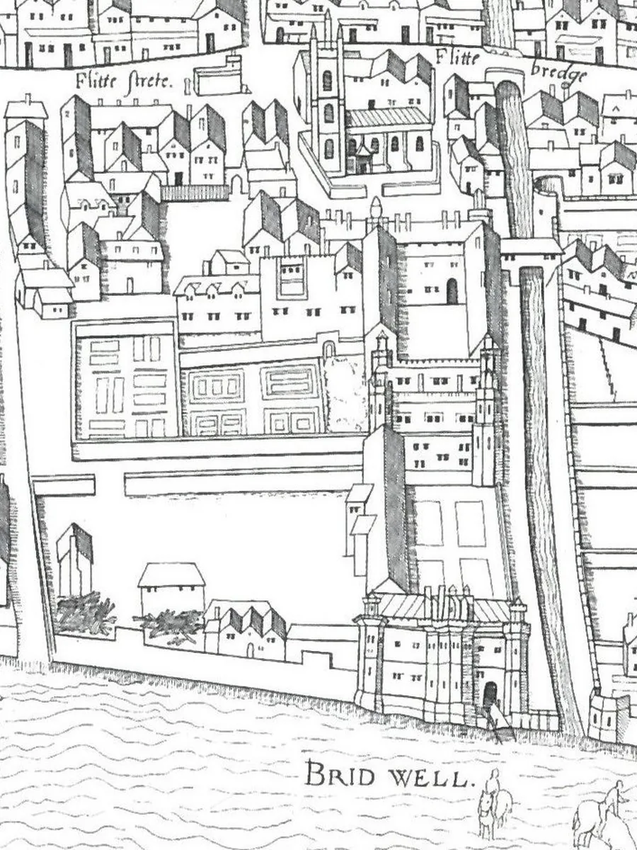
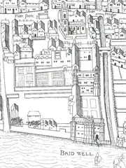
1559 · Open river. Bridewell Palace stands on the bank and Fleet Bridge carries the street over open water. The earliest true map of London, surveyed in the 1550s: the Copperplate’s Western City plate.
Map receipt
Survey c.1553–59 · Copperplate map, Western City plate · Public domain
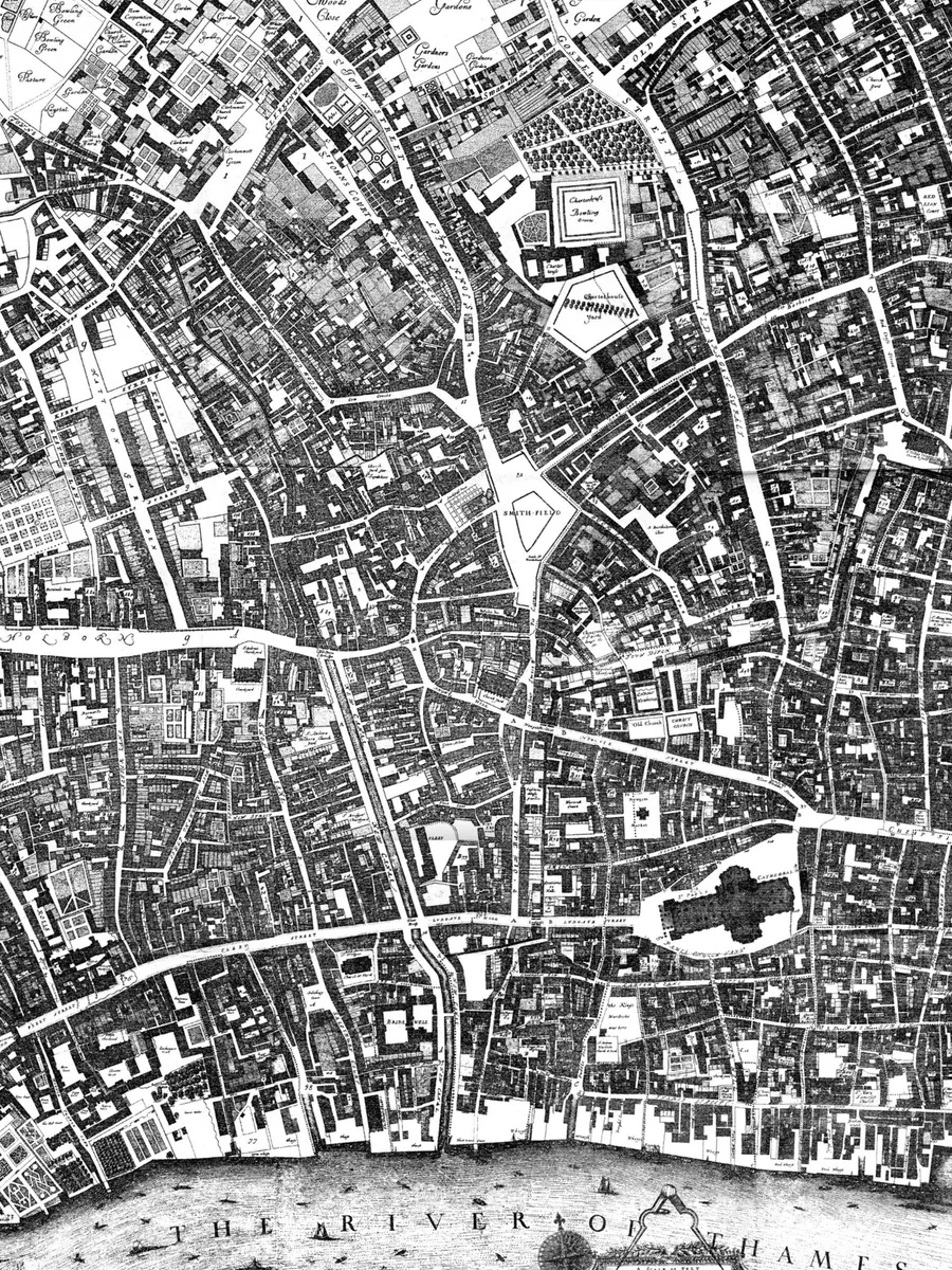
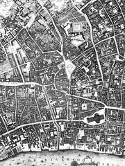
1677 · The canal. After the Fire the City straightens the ditch into the New Canal, built under Wren and Hooke: wharves and high arches, five feet of water at low tide. Follow the straight channel between Bridewell and Ludgate down to the Thames. Shown in an 1894 reduced copy of Ogilby and Morgan’s great map.
Map receipt
Survey 1676, published 1677 · Ogilby and Morgan, reduced copy 1894 · Public domain
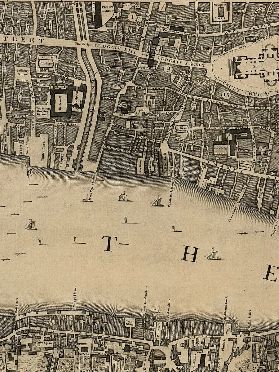
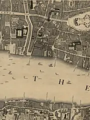
1746 · Half buried. Above Fleet Bridge the arches are finished and Fleet Market sits on top; below the bridge the ditch still runs open to the Thames. Rocque surveys the half-buried river — the market’s roofline where the water was.
Map receipt
Survey 1741–45, published 1746 · Rocque and Pine, City sheet · Public domain
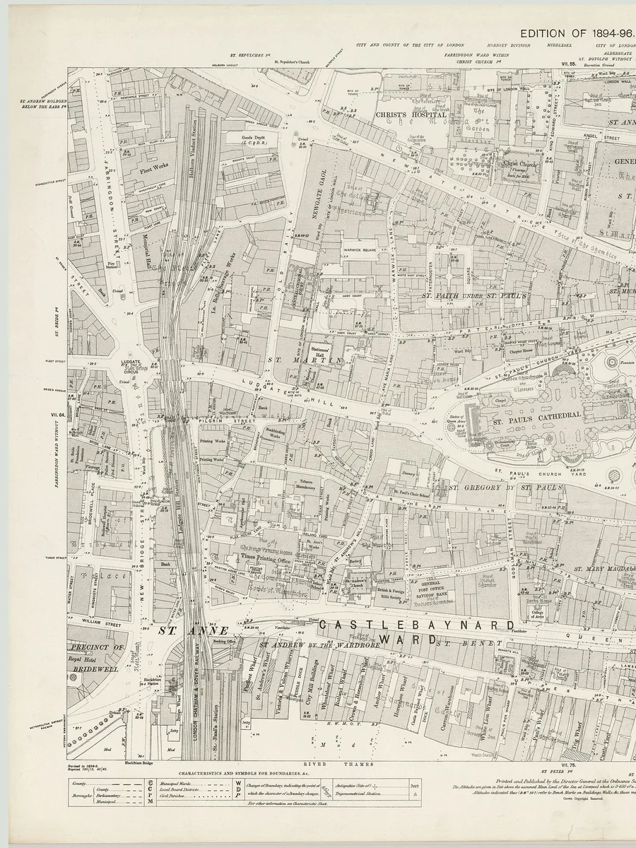
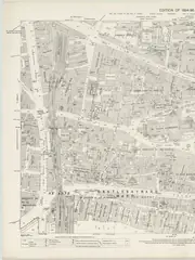
1896 · Only the valley. The river is gone. Its valley carries the railway viaduct past Ludgate Hill toward Blackfriars, and Farringdon Street runs where the market stood. Second-edition Ordnance Survey, five feet to the mile: the burial complete.
Map receipt
Revision 1891–95, edition of 1894–96 · Ordnance Survey London sheet VII.65 · Public domain
1559 · Open river. Bridewell Palace stands on the bank and Fleet Bridge carries the street over open water. The earliest true map of London, surveyed in the 1550s: the Copperplate’s Western City plate.
Map receipt
Survey c.1553–59 · Copperplate map, Western City plate · Public domain
1677 · The canal. After the Fire the City straightens the ditch into the New Canal, built under Wren and Hooke: wharves and high arches, five feet of water at low tide. Follow the straight channel between Bridewell and Ludgate down to the Thames. Shown in an 1894 reduced copy of Ogilby and Morgan’s great map.
Map receipt
Survey 1676, published 1677 · Ogilby and Morgan, reduced copy 1894 · Public domain
1746 · Half buried. Above Fleet Bridge the arches are finished and Fleet Market sits on top; below the bridge the ditch still runs open to the Thames. Rocque surveys the half-buried river — the market’s roofline where the water was.
Map receipt
Survey 1741–45, published 1746 · Rocque and Pine, City sheet · Public domain
1896 · Only the valley. The river is gone. Its valley carries the railway viaduct past Ludgate Hill toward Blackfriars, and Farringdon Street runs where the market stood. Second-edition Ordnance Survey, five feet to the mile: the burial complete.
Map receipt
Revision 1891–95, edition of 1894–96 · Ordnance Survey London sheet VII.65 · Public domain
Four surveys, four projections: the frames match on the Fleet corridor, not on every rooftop. Dates are survey years; each caption carries its receipt.
The acts
Each burial, dated
The Fleet was not buried once. It was scoured, canalised, arched, marketed, roaded, railed and intercepted — and each stage has its paper. The timeline gives every stage its date; the receipts give the act or the work.
Before the ditch
The valley was busy before London had a name for the stream. In 2024 MOLA dug a Roman cemetery by Holborn Viaduct — five oak coffins and the first complete Roman funerary bed found in Britain, preserved by the damp mud of the Fleet — with a thirteenth-century tannery and a Tudor water-pipe on the same ground. And the famous Blackfriars ship — a second-century vessel with Kentish ragstone, dug up in 1962–63 — lay in the Thames foreshore. It was never in the Fleet; the page keeps that distinction everywhere.
Three corrections
- No Roman ship ever sailed up the Fleet. The navigation story comes from a 1307 petition’s “times past” — evidence was never found.
- The prison was not built in 1197. In the ninth year of Richard I the keepers were fined sixty marcs for a keepership their family had held “ever since the conquest” — the prison is older than its first paper.
- The river never divided City wards: Fleet Bridge and Holborn Bridge both stood in Farringdon Without. It divided parishes and precincts; the wards it left alone.
1307
The petition
With the waterway choked by tanners’ filth, raised wharves and the Temple mills’ diversion, Henry Lacy tells the Carlisle parliament that ten or twelve ships with merchandise used to come to Fleet Bridge, and some to Holborn Bridge. A royal commission cleanses the channel and pulls the mills down — and the river never recovers.
1502
The scouring
In the seventeenth year of Henry VII the whole course of Fleet Dike is scoured down to the Thames, and boats with fish and fuel are rowed to Fleet Bridge and Holborn Bridge again.
1589
The failure
The Common Council votes a thousand marks for a Hampstead-springs scheme to flush the ditch. It fails, and Stow records the ditch “worse cloyed and choken than ever it was before.”
1670s
The New Canal
After the Fire the City canalises the Fleet under the rebuilding act: Wren and Hooke direct a navigable cut with wharves from Holborn Bridge to the Thames. It never pays — the canal the 1677 map shows is already a commercial failure.
1733
The act
Parliament passes the Fleet Ditch Act — sixth year of George II, chapter 22 — for filling the channel between Holborn Bridge and Fleet Bridge and vesting the ground in the City forever, on condition proper drains are made. No building above fifteen feet.
1735–37
The arches and the market
Two sewer arches, ten feet high and six wide, are completed between the bridges and covered over; Fleet Market rises on the site in 1737, taking the trade displaced from the Stocks.
1760–69
The lower covering
The Blackfriars Bridge act of 1756 pays for the rest: the reach from Fleet Bridge to the Thames is arched for the bridge approaches — Fleet Bridge and Bridewell Bridge come down in 1765, New Bridge Street opens the way, and the bridge accounts carry five thousand eight hundred and thirty pounds “for arching and filling up Fleet-ditch.” The bridge opens in 1769.
1826–32
The market goes
Fleet Market is cleared and Farringdon Street rises on the arched bed (named for a medieval goldsmith), with a new Farringdon Market for fruit and vegetables alongside.
1837–56
The road south
Acts of 1837–38 and 1840 carry Farringdon Street on toward Clerkenwell Green, with the new Fleet sewer aligned to the new road; the City boundary is reached in May 1841, Ray Street in 1855–56.
1855–65
The interceptors
The Fleet vests in the new Metropolitan Board of Works, and Bazalgette’s three northern interceptors tap it at three levels — High at Hampstead and Highgate, Mid at Clerkenwell Road, Low on the Embankment under Blackfriars. Dry-weather flow goes east to Beckton; only storm overflow still reaches the Thames, through the Fleet Main outfall.
1860–69
The railway and the viaduct
Farringdon Road is finished north to King’s Cross alongside the Metropolitan Railway’s cut-and-cover — the railway crosses the Fleet three times, and a collapsed sewer floods the cutting to Exmouth Street in June 1862. The road opens in February 1869; the Holborn Viaduct spans the valley the same year.
Today
The super-sewer
Tideway’s Blackfriars site intercepts the Fleet Main overflows — more than half a million tonnes of sewage a year that used to spill from the Fleet Sewer — into the twenty-five-kilometre tunnel for treatment at Beckton. Above the shaft, the Bazalgette Embankment’s acre of new riverside is open. The sewer itself stays a sewer; Tideway takes the overflows.
The traces
Ten traces, one walk
The river left fossils: names, grates, valleys, dips. Ten are mappable below — tick each one you have stood beside, and the tally keeps your walk. Two need luck with the weather; one is a legend, flagged as such.
The words
The Fleet in words
Five writers who saw the ditch — or its bridges — with their own eyes. Originals first, glosses after.
Ben Jonson
“On the Famous Voyage”, Epigrams, 1616 — a wherry ride of about 1610
“A dock there is, that called is Avernus, / Of some Bridewell…”Jonson’s drunk voyage rows from the Mermaid to Holborn by water: Bridewell dock, Fleet Lane, and three sergeants’ heads for Cerberus on Holborn Bridge. The underworld, with privies.
Jonathan Swift
“A Description of a City Shower”, Tatler number 238, 17 October 1710
“Filth of all hues and odour… / Sweeping from butchers’ stalls, dung, guts, and blood, / Drown’d puppies, stinking sprats, all drench’d in mud, / Dead cats, and turnip-tops, come tumbling down the flood.”Swift names Holborn Bridge; every reader knew which ditch the flood fell into.
Samuel Pepys
Diary, 1661–68 — three bridges, no ditch
“Followed me as far in the rain and dark as Fleet Bridge” (14 April 1661); “the Fleet Bridge is contracted for… to begin to be built this summer” (4 June 1668); “fain to go round by Newgate, because of Fleet Bridge being under rebuilding” (7 July 1668).Pepys never describes the Ditch. He crosses its bridges in the rain and walks round them while they are rebuilt — the river as commute.
John Stow
A Survey of London, 1603
“10. or 12. Shippes with Marchandizes, were wont to come to Fleete bridge, and some of them to Oldborne bridge… now the same course by filth of the Tanners… was sore decaied.”Stow copies the 1307 petition and adds two dates of his own: the scouring of 1502, when boats rowed to both bridges, and the failed flushing of 1589.
Alexander Pope
The Dunciad, Book II, 1728
“To where Fleet-ditch with disemboguing streams / Rolls the large tribute of dead dogs to Thames.”The most quoted two lines on the river. Editions disagree on the line numbers, so the page cites the book.
No Dickens — deliberately. Pickwick’s Fleet is the debtors’ prison, Fagin’s lanes never name the river, and Little Dorrit’s “deadly sewer” is the Thames in the Great Stink. The search was made; the line does not exist.
Sources
Receipts
Five shelves. The maps carry the burial, the statutes and the Survey carry the dates, and the last shelf carries the cuts — what the page refused to claim.
Maps in the slider
- Copperplate map: Bridewell and the open Fleet, c.1553–59 (map)
- Ogilby and Morgan: the canalised Fleet, 1677 (map)
- Rocque: the half-buried Fleet, 1746 (map)
- Ordnance Survey: the buried valley, 1894–96 (map)
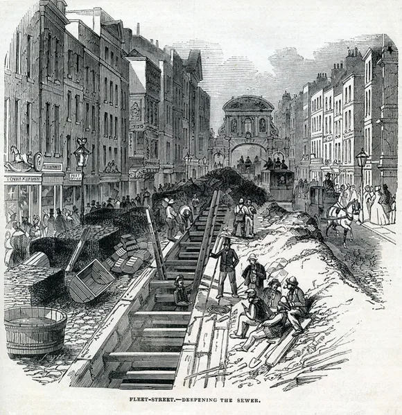
- Deepening the Fleet sewer, Illustrated London News 1845 (print)
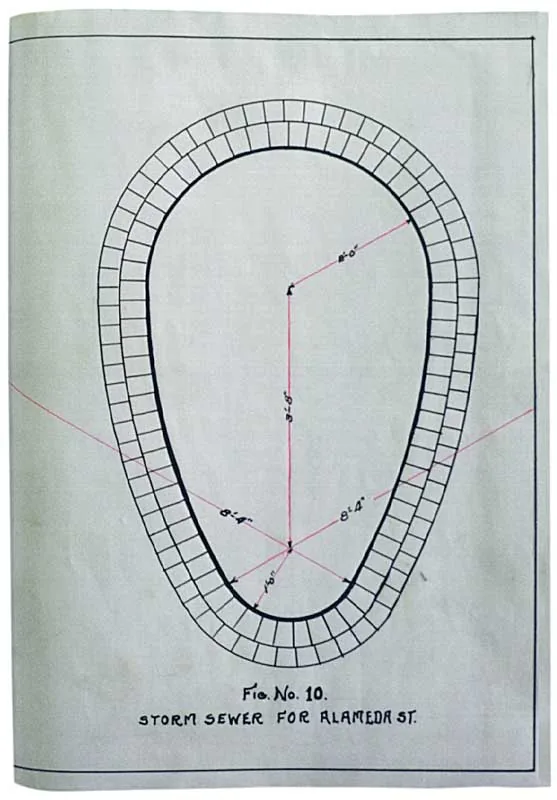
- Bazalgette’s sewer sketch, 1854 (diagram)


.jpg)


Acts and works
Course and traces
Words
Cuts and corrections
- Faithorne’s 1658 map: plate located, Fleet reach illegible in reproduction — cut.
- Roman ships up the Fleet: no evidence — cut.
- “Fleet Prison built 1197”: the paper is a keepership fine — corrected.
- The Fleet as a ward boundary: parishes, not wards — corrected.
- Hogarth’s Evening and any Dickens river line: verified absent — excluded.
- Turnagain Lane’s “no bridge” story: legend, flagged on the page.
Type: Fraunces and Source Serif 4, under the SIL Open Font Licence.
Keep walking
The river’s name is one Old English word — and the decoder next door parses two hundred and four London names the same way:
Short answers
Can you still hear the Fleet?
Yes — after rain, at the Ray Street grate outside The Coach, where the Fleet Sewer runs below the pavement. When the flow runs low the grate gives you nothing; that is the honest version.
When was the Fleet buried?
There is no one date. The canal came in the 1670s, the arches between Holborn and Fleet Bridge in 1735, the lower covering in 1760–68, Farringdon Road in 1841–69, and the interceptors in 1859–65. Pick a reach and the page gives you its year.
Why is it called Fleet Street if the river is gone?
The street is older than the burial: it ran to Fleet Bridge, and the bridge gave the crossing its name centuries before the arches. Names outlive rivers — Turnmill Street and Seacoal Lane are fossils of the same water.
Where does the Fleet go now?
Down the Fleet Sewer to Bazalgette’s interceptors, which carry dry-weather flow east to Beckton; storm overflows that once spilled under Blackfriars Bridge now go to Tideway’s tunnel instead. The river is infrastructure.