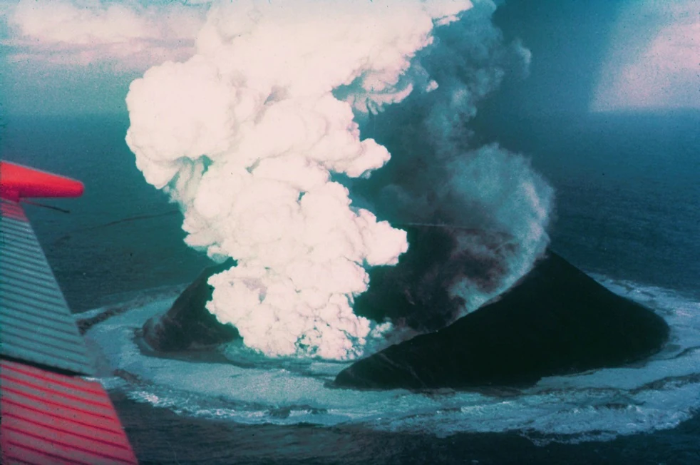
14 November 1963 · 07:15 · first confirmed visual sighting
Surtsey: the island born from water, measured by people
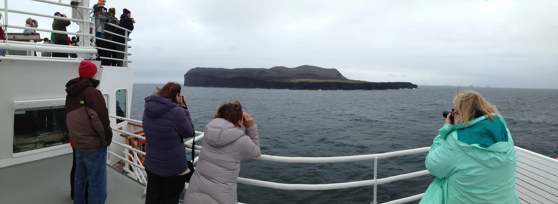
In November 1963, a volcano lifted Surtsey out of the Atlantic, south of Vestmannaeyjar and off the coast of Iceland. By 2019, its area above the zero-elevation reference plane had fallen by 53%. Between those moments, people mapped 10,094 plant occurrences, and evidence now points to birds as major seed carriers.
Howell Williams/NOAA · 1963
1963–1967 · THE OPENING
Surtur broke the sea, and Ísleifur II was the first to see it
On 14 November 1963, observers aboard the fishing vessel Ísleifur II saw a dark column of smoke rising off the coast of Iceland, south of Vestmannaeyjar. Sigurður Þórarinsson records the time as 07:15, Iceland mean time. The next morning, the island standing above the sea was about ten metres high. Nobody witnessed its beginning under the water; the chronology starts with what was seen and measured.
The eruption lasted three years and seven months, and lava moved for the last time on 5 June 1967. Two independent DEMs, from separate photographic campaigns, show how much of the island remains.
THE EVIDENCE HELD BY PEOPLE
Put the researcher’s lens over the plant map
Botanists identified plants in one-hectare grids. The digital set is not a single census: it combines annual surveys from 1965 to 1978, then surveys in 1980 and 1990. Points sit where the hand-drawn distribution maps were digitised.
Drag the lens across the island. Outside it, the points fade; inside it, they become legible. Tap near a point for the taxon and the place uncertainty. These are botanical records, not individuals, arrivals or living populations.
Use pointer or touch to move the lens. With a keyboard, focus the canvas and use the arrow keys.
| Year | Records | Taxa identified | Taxa cumulative |
|---|
1965–2025 · THE SURPRISE
The seeds without a passport travelled in birds
Cakile maritima was first found in 1965, then ash from Syrtlingur and the waves killed the seedlings. Only the sandwort Honckenya peploides first survived a winter, in 1968–69.
A 2014 study estimated that, of the 69 species then found on Surtsey, about 75% had been dispersed by birds, 15% by wind and 10% by the sea. An Ecology Letters study in 2025 goes further: trait classifications agreed consistently for at most 13% of species, while evidence for endozoochory by aquatic birds supports 62 of the 78 vascular plant species known from the island.
VASCULAR PLANT SPECIES WITH EVIDENCE FOR AQUATIC-BIRD ENDOZOOCHORY
The categories do not add up: species can carry several lines of evidence. Only one coloniser, Empetrum nigrum, was assigned the traditional endozoochory syndrome.
1990–2019 · HOW MUCH REMAINS
Ecological success includes disappearances
In a place that keeps changing, success is not linear. By 2013, 59 of the 69 species ever recorded were still present; 39 appeared to have viable populations. In 2015, of the 74 species registered between 1965 and 2015, 64 were living. From 2007, Surtsey has lost more species than it has gained.
In 2025, the study speaks of 78 colonising vascular plant species. The totals look different because they measure different sets and moments: 69 species seen by 2013, 74 seen between 1965 and 2015, and 78 analysed in 2025.
LIMITS, NOT AN ICON
What to know before reading the map
These are georeferenced botanical occurrence records, including repeated observations and points randomly distributed from mapped abundance.
The original 1965 and 1966 maps were unavailable; three positions were reconstructed from descriptions and carry 300 m uncertainty.
250 records carry 50 m uncertainty, some are one-hectare cell centroids for Honckenya in 1980 and 1990.
The 1967, 1974 and 2019 DEMs give three moments, not an annually measured outline; zero elevation is a chosen shoreline, not a fixed tide.
62 of 78 is the probative support for endozoochory by aquatic birds—not proof that every record travelled inside one particular gull.
The island is a closed scientific reserve; visits require permission. This page does not explain how to land there.
Sources and licences
- Óskarsson, B. V., Jónasson, K., Valsson, G. & Belart, J. M. C. (2020). Erosion and sedimentation in Surtsey island quantified from new DEMs. Surtsey Research 14, 63–77. Areas and volumes for 1967, 1974 and 2019.
- Wasowicz, P. et al. (2020). Vascular plant colonisation of Surtsey Island (1965-1990) – a dataset. Biodiversity Data Journal 8, e54812. The 10,094-record dataset, CC BY-NC 4.0; the article itself is CC BY 4.0.
- Wasowicz, P., Lovas-Kiss, Á., Szabó, N. & Green, A. J. (2025). Putative ‘Dispersal Adaptations’ Do Not Explain the Colonisation of a Volcanic Island by Vascular Plants, but Birds Can. Ecology Letters 28(10), e70234.
- Magnússon, B., Magnússon, S. H., Ólafsson, E. & Sigurdsson, B. D. (2014). Plant colonization, succession and ecosystem development on Surtsey with reference to neighbouring islands. Biogeosciences 11, 5521–5537.
- Magnússon, S. H., Wasowicz, P. & Magnússon, B. (2022). Vascular plant colonisation, distribution and vegetation development on Surtsey during 1965–2015. Surtsey Research 15, 9–29.
- Þórarinsson, S. (1965). The Surtsey eruption: course of events. Surtsey Research Progress Report I. 07:15 and the next morning at 10 m.
- Þórarinsson, S. (1968). The Surtsey eruption: course of events during the year 1967. Surtsey Research Progress Report IV.
- Fridriksson, S. (1966). The pioneer species of vascular plants in Surtsey. Surtsey Research Progress Report II.
- Petersen, A. (2009). Formation of a bird community on a new island, Surtsey, Iceland. Surtsey Research 12, 133–148.
- Surtsey Research Society. Its official pages on the eruption, conservation and colonisation. Chronology and protection.
- UNESCO World Heritage Centre. Surtsey. Protected status and history.
- OpenStreetMap contributors. The island outline as it is drawn today. This is not an annually measured shoreline.