A 1541 expedition · Amazonia · a question under the canopy
The river was full of people.
A starving Spanish expedition descended the Amazon and came back with a report of towns, chiefs, roads and war. For centuries, the report sounded impossible. Then the canopy began to lift.
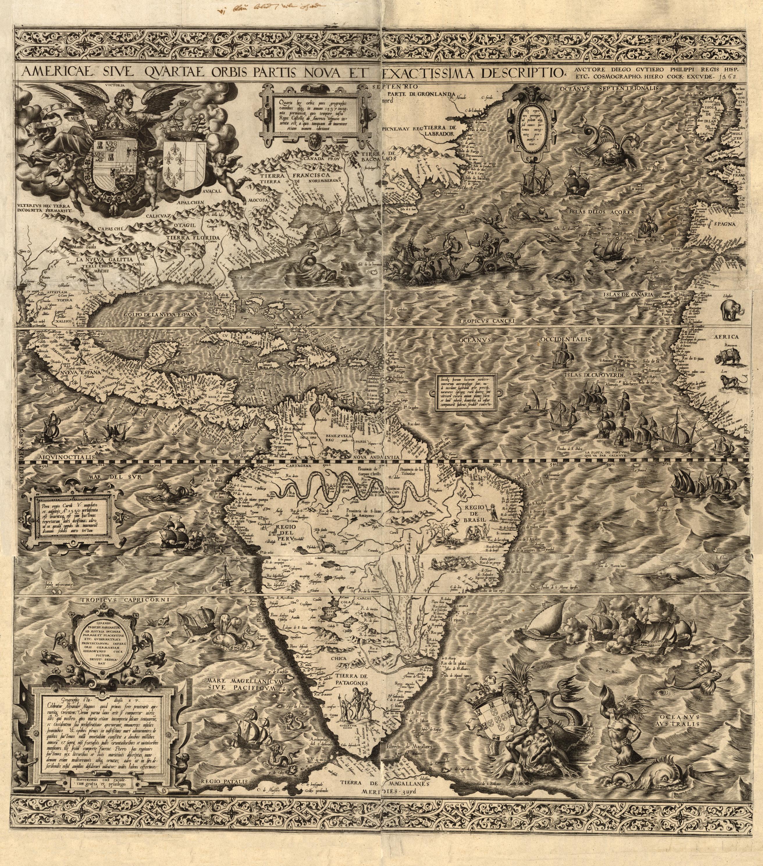
Historical image / 1562A map inside an imperial claim
AMERICAAntwerp · 1562The river is present. The people who lived along it are not the map's authors.
Historical map: Gutiérrez + Cock, 1562Read it as: geography and imperial ambition
01 / The detour
They went looking for food.
The expedition did not begin as a search for a lost civilization. It began with a camp running out of things to eat.
In late 1541, Gonzalo Pizarro's expedition was coming apart in the eastern foothills of the Andes. The men had crossed into a country they did not understand while searching for cinnamon and wealth. Rain ruined supplies. The ground swallowed horses. Hunger turned every green wall into a question.
Francisco de Orellana took a small party down the Napo in a rough brigantine called the San Pedro. The plan was simple enough: find food, load the boat, and fight the current back to Pizarro.
Then the river widened. The current became the strongest person in the expedition. They had gone too far to return quickly, and the farther they traveled, the more impossible the return became. The boat was no longer a supply run. It was a one-way door.
They repaired hulls, made nails, traded for provisions, and learned the river by surviving it. At one settlement they heard drums before they saw the people. At another, local leaders arrived by canoe. The crew had been looking for a pantry. Instead, it had entered a political world.
First sound
Drums in the trees.
First exchange
Food, canoes, names.
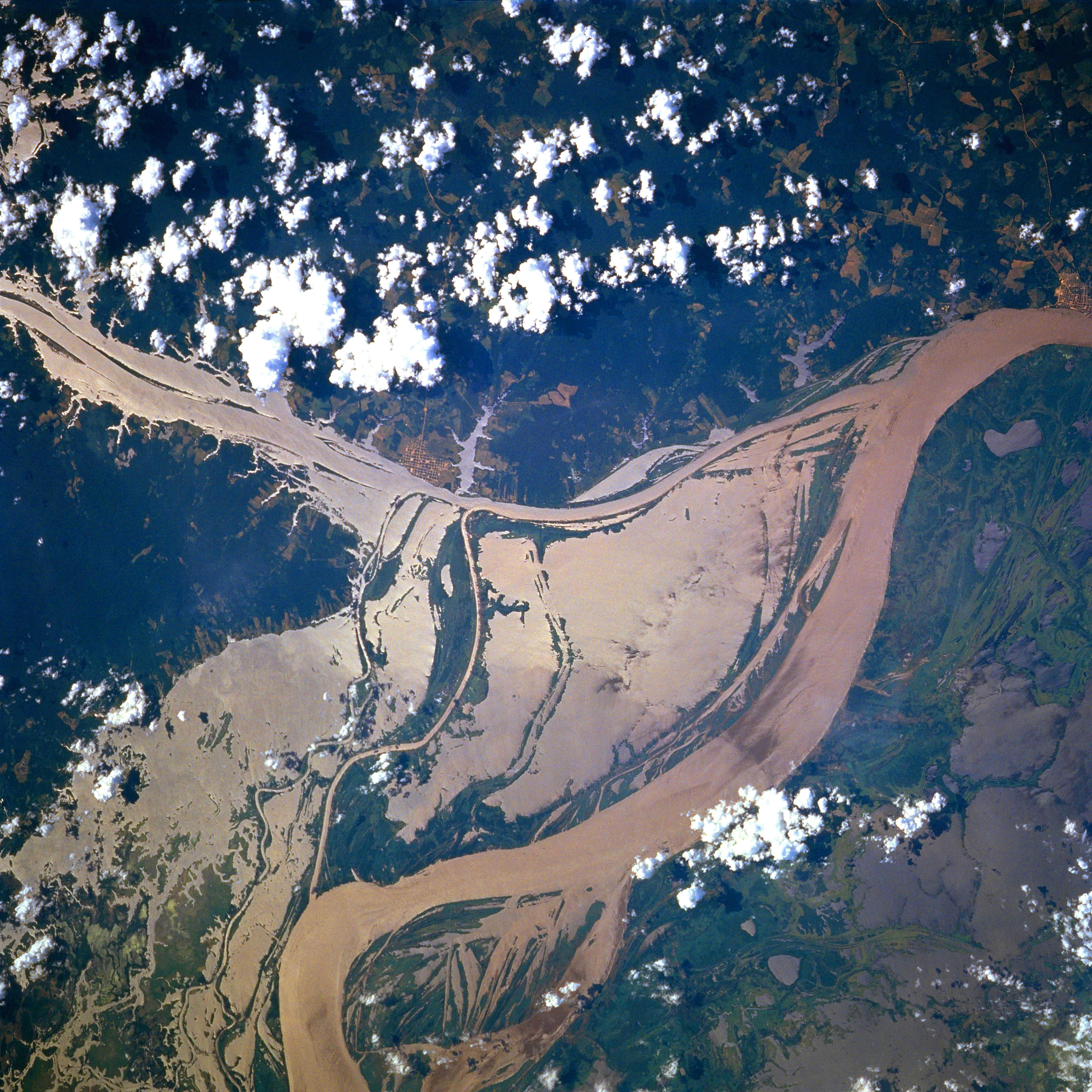
From above / NASA · 1996
The river from space: a braided world, not a single line.Amazon River near Óbidos, Brazil
02 / The record
Then the forest was crowded.
Gaspar de Carvajal, the Dominican friar who traveled with Orellana, wrote down what the crew saw. His account is a witness statement, not a census.
"Five leagues of houses, with no space between."
Carvajal's description, preserved in the 1934 English edition of the expedition account. A league was a period measure, not a modern survey unit.
The most startling passages describe long runs of settlement along the water. Carvajal writes of food stores, canoes, chiefs, defensive displays, and houses continuing until the bank seemed to become one inhabited place.
He also records roads leading away from the river. That detail matters. A settlement is not only a row of houses visible from a boat. It is a system of fields, paths, people, and obligations extending inland.
The report still has sharp edges. It was written by a member of a conquest expedition, for an audience that wanted reasons to fund more conquest. It translates unfamiliar political structures into European words. It includes the famous story of warrior women, a claim that cannot be treated as settled fact.
It can show a witness saw dense settlement.The repeated descriptions belong to the historical record, even when the observer's motives are part of the record too.
It cannot give us a clean population count.Numbers in a frightened travel account are not the same thing as an archaeological estimate.
It does not prove one Amazonian empire.The river connected many peoples. The surviving text does not establish a single ruler or capital.
Field instrument / read the layers
A map can lie by omission.
It is tempting to draw a straight line from Orellana's report to every recent discovery. That would be a better story and worse history. Put the layers beside each other instead.
Image ledger / choose a view
map · satellite · LiDAR
The map / 1562A river enters the archive as a claim.
Written view: the basin as European cartography framed it.Library of Congress
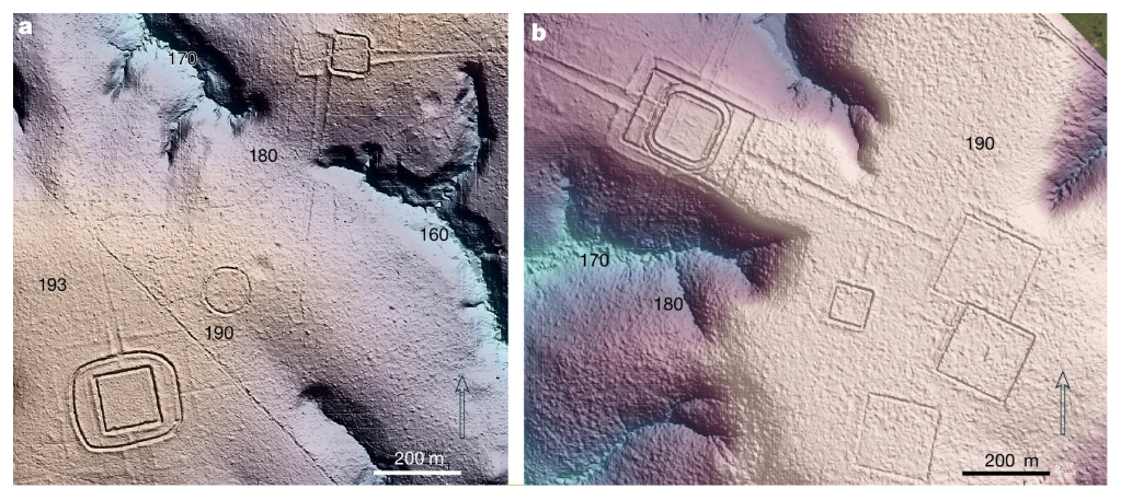
The ground / 2026Vegetation becomes terrain.
Ground view: Aquiry earthworks and roads revealed by LiDAR.CC BY 4.0
Map / 1562
LiDAR / 2026
Two instruments: one draws a world from the river; the other recovers geometry from beneath the canopy.
Historic map
The hero image is a 1562 map by Diego Gutiérrez and Hieronymus Cock. It was made decades after the voyage, yet it catches the essential problem: the Amazon appears inside a European picture of possession. The river is visible. Its peoples are not the map's authors.
Choose evidence view
Historic map selected.
historical cartography river from above LiDAR ground evidence
These images come from different places and times. They are evidence windows, not a geographic overlay and not proof that any pictured site was an Orellana stop.
A shared landscape does not make a shared identity. The connection is a question for evidence, not a shortcut for the story.
03 / The blank on the map
How a living world becomes a blank.
The later silence was real. The idea that it proves the first account was fiction is the part that does not hold.
1541–42
The first report
Carvajal records stretches of settlement, leaders arriving by canoe, stored food, and roads running inland. His account is extraordinary, interested, and impossible to ignore.
after contact
The river changes
European intrusion brought disease, enslavement, warfare, mission pressure, and forced movement. The populations that later observers met were not living under the same conditions as the populations the first expedition encountered.
18th–20th c.
The forest closes
Wood, thatch, gardens, paths, and raised earth do not announce themselves like a stone wall. Once people leave, the vegetation returns. A road becomes a low line. A plaza becomes a level patch. A town becomes a handful of mounds under trees.
now
The ground answers back
Archaeologists use dark earth, ceramics, ditches, mounds, roads, pollen, charcoal, and laser mapping to read the landscape as a record of work. The forest is still there. It is no longer being mistaken for the whole story.
04 / The canopy lifts
The ground kept a second account.
Recent archaeology does not give us a key that opens every sentence in Carvajal. It does something more useful. It makes the old idea of an empty Amazon impossible to keep intact.
Upano ValleyEcuador
6,000+
structures
LiDAR revealed mounds, plazas, roads, terraces, drainage works, and fields across an approximately 300 km² survey area.
The network began around 500 BC and lasted for centuries. It is a different valley, not a missing pin from Orellana's route.
Upper XinguBrazil
roads + plazas
forest urbanism
Archaeology documents large settlements, ditches, causeways, and planned relationships between communities.
Researchers use "low-density urbanism" for a landscape organized around settlements and gardens rather than a single dense stone core.
Llanos de MoxosBolivia
22 m
earthen pyramids
Airborne laser mapping exposed elevated roads, canals, reservoirs, and monumental mounds built by the Casarabe culture.
The structures show that a tropical wetland could hold planned, connected centres. They do not establish one basin-wide political system.
Aquiry regionSouthwest Amazonia
24–30k
earthworks, estimated
A 2026 Nature study combined satellite imagery, fieldwork, and LiDAR to estimate the scale of a geometric earthwork civilization.
The same paper models 1.25–3 million people around AD 100–300. Both figures are extrapolations, not a census.
What LiDAR sees
An aircraft sends laser pulses through gaps in the canopy and measures the returns. The resulting terrain model can reveal a ditch, embankment, road, or mound that is almost invisible from the ground.
It cannot recover a people's names, voices, memories, or political relationships by itself. That is why the page keeps written testimony, archaeology, and interpretation in separate columns.
The honest answer has more texture than a yes or a no.
Broadly, yes.
The report is strongest when it describes a river lined with organized Indigenous societies. It becomes fragile when later readers turn a moving, plural landscape into one lost capital.
The expedition reached the Atlantic.
attested
Some river stretches held dense settlements.
supported
Amazonian societies engineered land at large scales.
supported
One empire ruled the whole river.
unproven
Every reported settlement has been found.
unknown
The forest was untouched before contact.
wrong frame
Last page / close the notebook
The lost city was the wrong question.
There may never be one spectacular ruin waiting under the leaves to close the case. No single ruin is needed. Across different Amazonian regions, Indigenous peoples built towns, roads, canals, fields, ceremonial spaces, and political worlds that left a lighter signature than stone.
Carvajal's account is not a passport to every dramatic claim. It is a damaged window. Through it, the river looks less like a wilderness that briefly surprised a few Spaniards and more like a populated world that colonial violence made difficult to see.
Sources / how to read the evidence
Keep the receipts.
The page uses "supported" for claims backed by more than one line of evidence, "plausible" for a careful fit, and "unknown" when the evidence cannot close the gap.