Bryn Mawr · Llandysilio, Powys, Wales
There is an Iron Age fort under this wood
From the air, Bryn Mawr is a small hill covered in trees. In February 2021 an aircraft swept it with laser pulses, and some of them slipped between the branches to the ground. Keep only those, and the wood is gone. Underneath lies a rampart, a ditch, what looks like a gateway and a scatter of shallow hollows.


Drag the view to turn it.
How can a laser see through a wood?
The aircraft fires laser pulses at the ground and times each echo. Most pulses bounce off the first thing they meet: a tree top, a roof, a hedge. Some pass through gaps in the crowns and bounce off the ground. This survey was flown in winter, on 22 February 2021.
Two maps are made from the echoes. The surface model keeps the tops of whatever the pulses hit, so over Bryn Mawr it shows the wood. The terrain model keeps only the echoes classed as ground and fills the gaps between them. The view at the top moves from one to the other.
The difference between the two is roughly the height of the trees. Inside the ditch of the fort, the tree tops stand more than 9 metres above half the ground and more than 15 metres above a tenth of it; the tallest reaches 22 metres. In the surface model the fort does not show at all.
What is on top of Bryn Mawr?
A single rampart runs round the summit, with a ditch outside it and, beyond the ditch, the trace of a smaller bank. The Royal Commission on the Ancient and Historical Monuments of Wales, which keeps the national record, describes it in its January 2026 entry as a roughly pentagonal fort about 105 metres east to west and 108 metres north to south, enclosing 0.84 hectares to its outer edge. On the north and north-east the rampart runs in straight lengths.
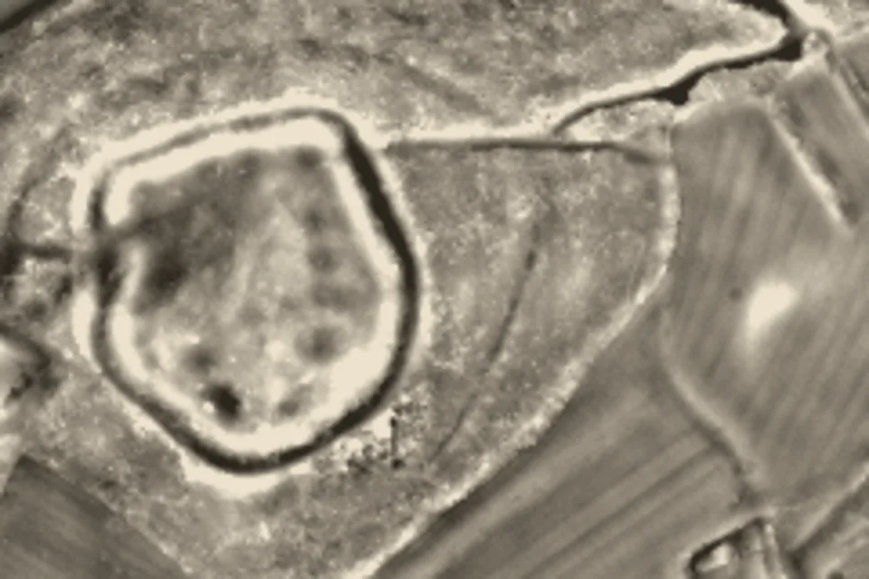
2021 survey, one-metre grid
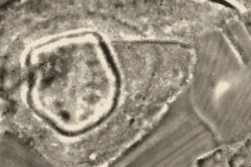
2006 survey, half-metre grid
Measured from the terrain
- top of the rampart
- bottom of the ditch
- hollow found in both surveys
- hollow found in 2021 only
Read by the national record (Coflein, 2026)
- where the record places up to ten possible house platforms
- gateway and possible barrow
On the north-west side the line of the rampart pulls sharply inward. The record reads this as the gateway, perhaps with the rampart ends overlapping, opening onto a natural gully that climbs to the domed top of the hill, which is otherwise too steep to reach from that side. In the terrain the line of the rampart steps in by about twelve metres at that point.
The fort was known before this survey. An older entry in the same record, taken from an Ordnance Survey card, already describes two lines of scarps round the summit, read as a worn-down rampart and ditch, with a possible entrance on the west. The terrain model shows the whole plan at once, including the ground inside.
Did people live inside the hillfort?
Inside the rampart the ground is uneven. The record notes up to ten hollows in the southern part that may be house platforms, levelled places where houses stood, and says a finer survey would settle the detail.
A hollow in a terrain model can come from the processing as easily as from the ground, so the same rule was run on two separate surveys: the 2021 one and an older one flown in November and December 2006 on a half-metre grid. The rule counts every closed dip at least 15 centimetres deep and at least four square metres across, more than three metres inside the rampart. Six hollows appear in both surveys, their centres no more than three metres apart; the count changes with the depth threshold, as the notes at the end explain. They are 22 to 52 centimetres deep and 9 to 59 square metres in area. Three lie in the southern half, where the record places its hollows; three more lie in the north.
A hollow is not yet a house. When a tree blows over, its torn-up roots leave a pit, and people also dug small quarries on hilltops for stone. A finer survey would show their shape more clearly; telling a house platform from the rest would likely take an excavation, and the record describes none here.
What is the mound east of the fort?
Some 88 metres east of the fort, in the record’s measurement, a rounded mound stands in an open field, 10 to 15 metres across. In the terrain it rises about two metres above the slope around it, and it is there in both surveys. The record suggests that, unless it is natural, it may be a barrow, a burial mound placed on the approach to the fort. The record gives no date for it.
How old is Bryn Mawr hillfort?
The record assigns it to the Iron Age and gives no closer date. In Britain that period covers roughly the eight centuries before the Roman conquest in the first century AD.
Sources and method
Record: Coflein, the online catalogue of the Royal Commission on the Ancient and Historical Monuments of Wales, site 306987, Bryn Mawr hillfort, entry by Toby Driver, January 2026, and the earlier entry of 11 November 2002. Descriptions of the fort, the gateway, the house platforms and the mound are summarised from it.
Terrain and surface: Welsh Government LiDAR 2020–23, one-metre terrain and surface models, DataMapWales; the tiles used here were flown on 22 February 2021. Contains public sector information licensed under the Open Government Licence v3.0. Second survey: Natural Resources Wales LiDAR archive, half-metre terrain model, flown in November and December 2006. Contains Natural Resources Wales information © Natural Resources Wales and Database Right. All rights reserved.
The plans show local relief: the terrain minus its average over a 15-metre square. A hollow is a closed area at least 15 cm below that average, of 4 to 200 square metres, more than 3 metres inside the traced rampart; the 2006 grid is averaged to one metre first, and a hollow counts as found in both surveys when the two centres lie within 3 metres. With a 10 cm threshold seven hollows are found in both surveys; with 20 cm, four. Two more appear only in 2006. The rampart line is the highest point of local relief along 72 bearings from the centre of the fort, the ditch line the lowest point within 12 metres outside it, both smoothed. Tree heights are the surface model minus the terrain model, inside the traced ditch.
Nothing here is reconstructed: no houses, no palisade, no rampart heights. The lines and rings are measured; the gateway, the house platforms and the barrow are the record’s reading.