The whole fortress, in words
The 14 stops of the walk, in the order of the path. Each says how it is known.
Four ways of seeing
- Today’s citytoday’s buildings and parks
- Still standingthe surviving walls, the cathedral, the Serbian cathedral, the Baroque Palace, the Old Town Hall
- Shown on the plansthe lines of walls, the ditches, the gates, the barracks, houses on their plots
- Assumedroofs, the suburbs, the exact shape of the outer works
How big was the empty field round the fortress of Timișoara?
1 Shown on the plans
On the empty field, at the edge of Iosefin
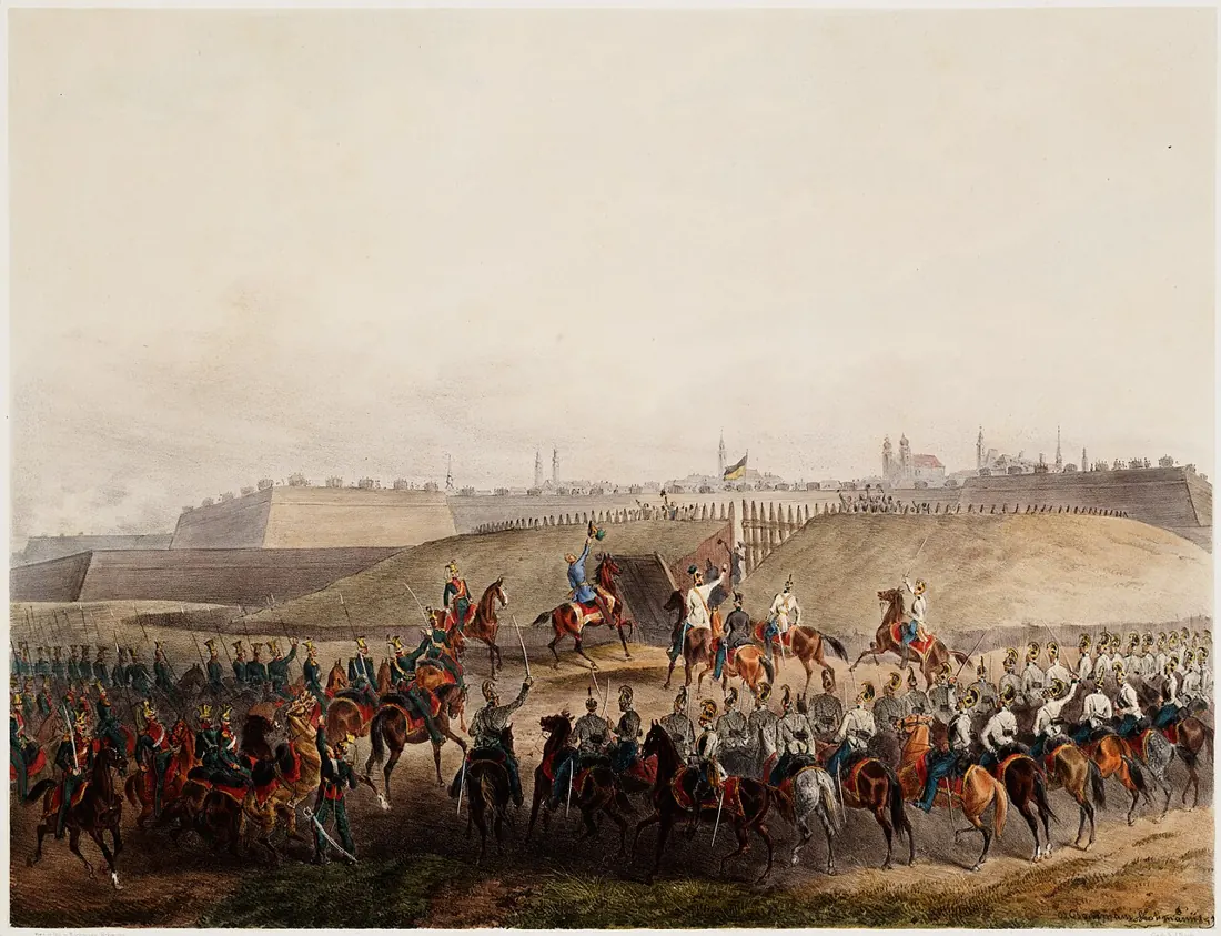

In 1853 the ground between the houses of Iosefin and the walls was mostly open field. A military plan of 1772 draws the zone where building was forbidden: 500 Vienna fathoms from the corners of the covered way, which is 948 metres. On Preyer's plan of 1853 a yellow line runs round the fortress at about that distance, and the houses of the suburbs stop at it. Emperor Francis I found the field by the Vienna Gate “entirely grown over with grass” in 1807.
The fortress was built to be hard to see from here. The walls sat low, behind long slopes of earth, so that cannon could not reach them. From the edge of the field the whole fortress is a stripe on the horizon with the town's towers above it. In 1868 the forbidden zone shrank to 300 fathoms, 569 metres.
Sources
- Plan of the Esplanade, 1772 (HM HIM, G I h 669)
- J. N. Preyer, Monographie der königlichen Freistadt Temesvár (1853), pp. 98–99 and the town plan
- Diary of Emperor Francis I, 1807, ed. Feneșan, Analele Banatului XXXIII (2025), pp. 290–294
- József Geml, “Temesvár újkora”, in Borovszky (ed.), Temesvár (1914)
2 Shown on the plans
On the crest of the glacis
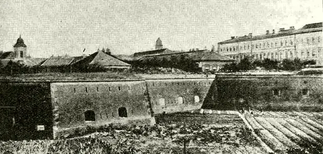

The long grass slope you have climbed is the glacis. It was about 265 metres wide and nowhere less than 105. Its crest hid the soldiers in the covered way. One ditch among the outer works was kept dry, but could be flooded through two sluices.
The wall in front of you is the envelope, the third and outermost line of defence. A section drawn in 1877 through one of its works gives the heights: the brick face rose 2.89 metres above the floor of the ditch beside it, and the earth crest reached 5.90 metres. Here every part of the envelope is given that profile.
What did the walls, ditches and gates of the fortress look like?
3 Shown on the plans
The long bridge over the wet ditch
Preyer describes in 1853 an irregular bastioned nonagon with counterguards and an envelope in front of it: three lines of defence, one behind the other. To reach the Petrovaradin Gate you crossed a long bridge between the first and the second line.
The water came from the Bega. Emperor Francis I noted in 1807 that the river “also fills the town ditches”, flowing in at the Transylvania Gate and out at the Petrovaradin Gate. In 1821 a traveller wrote of “wide water ditches”. The water level in 1853, ditch by ditch, is not known.
Sources
- J. N. Preyer, Monographie der königlichen Freistadt Temesvár (1853), pp. 98–99 and the town plan
- Romanian Wikipedia: Cetatea Timișoarei (heritage codes of the fragments)
- Diary of Emperor Francis I, 1807, ed. Feneșan, Analele Banatului XXXIII (2025), pp. 290–294
- Kopeczny and Pánya: Mindszenthy's description (1821) and the gate elevations of 1808, Analele Banatului
4 Shown on the plans
The Petrovaradin Gate, from the town side
Vicze dates the opening of the gate towards Iosefin to 1741 and its completion to 1750. The elevation drawn in 1808 shows its central arch of dressed stone, a triangular pediment and two lower openings at the sides. It was the only gate kept open until 11 at night; the other two closed at 9.
Into the town led only narrow, winding passages that followed the angles of the bastions, and the bridges over the ditches. Only in 1869 was a second opening allowed in the gates for carts, and a third for the horse tram. Here the façade is shown simplified, after the 1808 elevation.
Sources
- Vicze, “Az év Temesvárban”, pp. 83–85 (Banaticum)
- Kopeczny and Pánya: Mindszenthy's description (1821) and the gate elevations of 1808, Analele Banatului
- József Bellai, “Temesvár leirása”, in Borovszky (ed.), Temesvár (1914)
- Romanian Wikipedia: Cetatea Timișoarei (heritage codes of the fragments)
- József Geml, “Temesvár újkora”, in Borovszky (ed.), Temesvár (1914)
5 Shown on the plans
On the rampart of the Mercy bastion
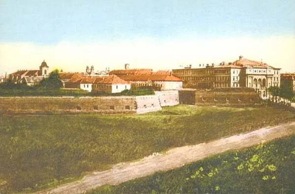

From the rampart you see over the roofs to the cathedral towers. The rampart on the town side was the highest: 10–12 metres, Adam Cucu wrote in 1931, and an architectural study gives it a width of 15–20 metres. Beyond it, towards the field, come the counterguards, then the envelope, then the glacis. The whole belt was about 585 metres deep on average.
Preyer noticed a flaw in 1853: the fortress had been built on marshy ground and the walls had sunk, the main rampart more than the works in front of it. So one line could not fire over another without hitting its own men. The postcard of 1906 shows the Mercy and Eugen bastions shortly before the demolition.
Sources
- Adam Cucu, Cetatea și harta cetății Timișoara (1931), pp. 16–17
- Volkmann, dissertation on the architecture of Timișoara, pp. 84–88 (Heidelberg University)
- Ciprian Glăvan, on the demolition of the fortress, Analele Banatului, pp. 422–427
- J. N. Preyer, Monographie der königlichen Freistadt Temesvár (1853), pp. 98–99 and the town plan
6 Still standing
What was found by the Eugen bastion
The Eugen bastion was finished in 1734 and is named after the prince who took the town in 1716. Its southern ear and flank still stand, by Piața 700. Nearby, behind the former hospital of the Brothers of Mercy, a piece of the wall between the Mercy and Eugen bastions escaped demolition: it is now the exhibition room Cazemata 54.
In 2006, digging for a foundation uncovered the bastion's counterguards, and in 2013 an 18th-century sluice. The report of the excavation by Piața 700 gives the ditch in front of Counterguard I a width of 18.75 metres and bricks of 32 by 18 by 8 centimetres. The width of that ditch in this reconstruction is the one measured then.
Sources
- J. N. Preyer, Monographie der königlichen Freistadt Temesvár (1853), pp. 98–99 and the town plan
- Romanian Wikipedia: Cetatea Timișoarei (heritage codes of the fragments)
- Banaticum, “Itinerarii timișorene: Cetate”
- Ghidul Banatului, Cazemata 54, 9 October 2025
- Chronicle of Archaeological Research, report 5410: City Business Center, Piața 700
7 Still standing
The Vienna Gate and the casemate of Ravelin VIII
The gate in the north-north-west, between the Elisabeth and Carol bastions, led to Mehala and the road to Arad. It was finished in 1749. The elevation of 1808 shows a tall central arch, a curved pediment and carved trophies.
The gate went in 1891, but the casemate of Ravelin VIII, which covered it from the side and held ammunition, still stands on Calea Alexandru Ioan Cuza. The stone at corners, cornices and embrasures was a yellow sandstone; the walls were of fired brick, with rammed earth behind.
Sources
- Volkmann, dissertation on the architecture of Timișoara, pp. 84–88 (Heidelberg University)
- Kopeczny and Pánya: Mindszenthy's description (1821) and the gate elevations of 1808, Analele Banatului
- Romanian Wikipedia: Cetatea Timișoarei (heritage codes of the fragments)
- Ciprian Glăvan, on the demolition of the fortress, Analele Banatului, pp. 422–427
- Iovănescu, study of the Timișoara fortification, pp. 17–19
- Dan Vlase, Patrimonium Banaticum VI (2016), p. 308
What was in the town between the walls in 1853?
8 Still standing
The parade square
Today's Piața Libertății was the garrison's parade square. On one side stands the German town hall, built between 1731 and 1734 and rebuilt in 1782; it was hit in the siege of 1849.
The siege lasted 107 days, until August 1849. When the gates closed in April, more than three thousand civilians were still in the town, according to Preyer. Most houses inside the fortress had a ground floor and one upper floor; on the main streets there were houses of two and three upper floors, with shops at street level.
Sources
- Heritage of Timișoara: Piața Libertății 1 (the Old Town Hall)
- Jenő Szentkláray, “Temesvár története”, in Borovszky (ed.), Temesvár (1914)
- J. N. Preyer, Monographie der königlichen Freistadt Temesvár (1853), pp. 98–99 and the town plan
- Heritage study approved by Timișoara council decision 208/2011 (copy in the hcl.usr.ro register)
- József Geml, “Temesvár újkora”, in Borovszky (ed.), Temesvár (1914)
9 Still standing
The cathedral square
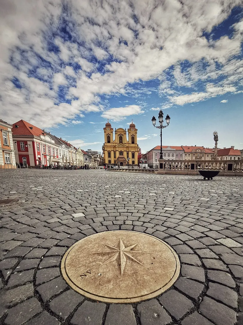

The Roman Catholic cathedral was built between 1736 and 1774. Its towers are 35.5 metres high and its nave 16.90. Across the square, the Serbian cathedral was rebuilt between 1745 and 1748 and received its two towers in 1791. The Baroque Palace on the south side had a ground floor and two upper floors from 1752, and from 1754 it was the residence of the president of the Banat.
These three buildings still stand, which is why they have their colours. The houses around them are drawn on today's plots, with limewashed walls and roofs in ink: what each looked like in 1853 is not known.
10 Shown on the plans
The castle, after the siege
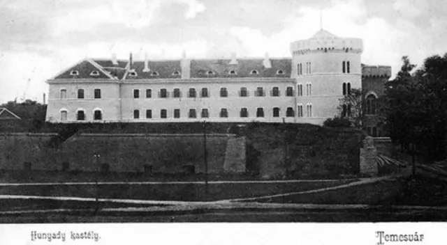

Huniade Castle, rebuilt for John Hunyadi between 1443 and 1447, was in 1807 an arsenal with two upper floors. In the siege of 1849 its north side was destroyed. In 1853 it still stood like that; the Austrians rebuilt it between 1854 and 1856 in today's form.
The photograph, from around 1900, shows the rebuilt castle behind the Castle bastion, which was still standing. In the reconstruction the castle has three sides and no north side; their shape is inferred, not measured.
11 Shown on the plans
The Transylvania barracks
The first lasting building of the new fortress was an infantry barracks with bomb-proof vaults, put up between 1727 and 1729. It closed the south-east side of the town, and at its end opened the gate to Fabric. In 1849 it was one of the few buildings that could shelter people under bombardment.
The barracks were demolished in the 1960s. On their ground today are Parcul Civic and the Hotel Continental; one remnant in the park serves as a stage. Here they are drawn as a long block, in their position on the plans.
What is left of the fortress of Timișoara?
12 Still standing
The Theresia bastion, the only one kept almost whole
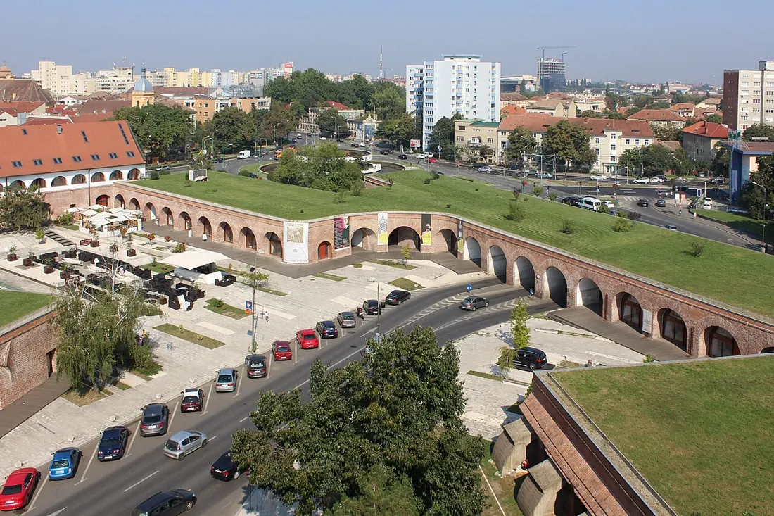

The Theresia bastion was begun in 1732 and finished in 1734, the first of the nine. It was the fortress's provisions store, with room for up to 2,800 tonnes of flour, and took Maria Theresa's name in 1744. It is the only one kept almost whole.
In the 1930s its demolition was still being discussed. It was restored in 1968–1969, with major changes and partial demolition, and again in 2008–2010, when it lost some original elements. Today it stands alone on the level ground of the city, where the ditches and the glacis were.
13 Shown on the plans
Towards Fabric, the Transylvania Gate
The east gate led to Fabric and the Lugoj road; the elevation of 1808 shows a central arch under a triangular pediment. The road between Fabric and the fortress appears on plans from the 1740s: it is the line of today's Bulevardul 3 August 1919.
The gates fell first, in 1891. The great demolition began after the contract of 15 June 1905. By the end of 1911, 25,819,000 whole bricks had been taken out of the walls. The land of the works measured 1,380,460 square metres.
Sources
- Kopeczny and Pánya: Mindszenthy's description (1821) and the gate elevations of 1808, Analele Banatului
- Fortepan, photograph 9502: the Transylvania Gate being demolished (CC BY-SA 3.0)
- Ciprian Glăvan, on the demolition of the fortress, Analele Banatului, pp. 422–427
- József Geml, “Temesvár újkora”, in Borovszky (ed.), Temesvár (1914)
14 Today’s city
Where the glacis was, today
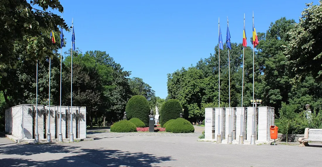

The ring of parks round the old town stands where the demolished works were: Central Park, Rose Park, Children's Park. No house was built on the ground of the walls before 1910. The boulevards joining the centre to Iosefin and Fabric run where the empty field was.
Drag the handle back towards 1853: today's city sinks, and the ditches, the walls and the empty field return on the same ground. Today's buildings come from OpenStreetMap.
How exact the reconstruction is
The line of the main rampart, with its nine bastions, is read off the main plan of the fortress of 1788, laid on today’s streets. The points of the Mercy, Eugen and Elisabeth bastions were then moved by 30–55 metres so that the walls still standing fall on the line: the ear of the Eugen bastion is now half a metre from it, the wall in the Botanic Park 3 metres, and the ends of the wall at Cazemata 54 9–21 metres. Between the points of the bastions the line is drawn by Vauban’s rules.
The counterguards and the envelope are set at the distances on the same plan, with the 18.75-metre ditch measured in the excavation by Piața 700. The result was checked against Preyer’s plan of 1853, which is independent: the counterscarp of the outer ditch, where the covered way begins, lies on average 26 metres from the outline of the fortress Preyer drew and encloses 103.9 hectares, against 105.6 on his plan. The exact shape of each counterguard and ravelin is assumed.
The heights come from three sources: the main rampart of 10–12 metres, the envelope with its 2.89-metre brick face and its earth crest 5.90 metres above the ditch floor, after the section of 1877, and the glacis of about 265 metres. The counterguards were given the envelope’s profile. The ditches on the town side are drawn with water, after the accounts of 1807 and 1821; the water level is assumed. The outer one is dry, with a narrow channel down the middle.
The Roman Catholic cathedral, the Serbian cathedral, the Baroque Palace, the Old Town Hall and the church of St Catherine are drawn on their outlines of today; the cathedral’s towers are 35.5 metres high. The height of the Serbian cathedral’s towers is not given in the sources used and is approximate. The other houses stand on today’s plots, with a ground floor and one or two upper floors, after the city’s heritage study; their roofs are assumed.
The suburbs, Iosefin, Fabric and Mehala, are set on the built blocks of Preyer’s plan: small houses along the block edges at 6-metre steps, though not on every step. The woods to the north and west that Preyer mentions are suggested on the horizon.
The light is that of a late-October afternoon, with the sun low in the west-south-west; it was chosen, not computed for a given day. Today’s city comes from OpenStreetMap, with the heights given there or worked out from the number of floors.
Sources
The military plans of 1772, 1788 and 1852 are in the Institute and Museum of Military History in Budapest. The description of 1853 is Preyer’s monograph. The figures on the demolition come from the volume Temesvár of 1914. The measurements come from the excavation reports and the studies cited below. Timișoara is in western Romania; Iosefin, Fabric and Mehala are its old suburbs.
- Plan of the Esplanade, 1772 (HM HIM, G I h 669)
- J. N. Preyer, Monographie der königlichen Freistadt Temesvár (1853), pp. 98–99 and the town plan
- Diary of Emperor Francis I, 1807, ed. Feneșan, Analele Banatului XXXIII (2025), pp. 290–294
- József Geml, “Temesvár újkora”, in Borovszky (ed.), Temesvár (1914)
- Ileana Kisilewicz, habilitation thesis, Politehnica University of Timișoara, pp. 15–16
- Iovănescu, study of the Timișoara fortification, pp. 17–19
- Ene, Micle, Iliuță, Materiale și Cercetări Arheologice XVIII (2022), pp. 135 and 139 (the 1877 section)
- Romanian Wikipedia: Cetatea Timișoarei (heritage codes of the fragments)
- Kopeczny and Pánya: Mindszenthy's description (1821) and the gate elevations of 1808, Analele Banatului
- Vicze, “Az év Temesvárban”, pp. 83–85 (Banaticum)
- József Bellai, “Temesvár leirása”, in Borovszky (ed.), Temesvár (1914)
- Adam Cucu, Cetatea și harta cetății Timișoara (1931), pp. 16–17
- Volkmann, dissertation on the architecture of Timișoara, pp. 84–88 (Heidelberg University)
- Ciprian Glăvan, on the demolition of the fortress, Analele Banatului, pp. 422–427
- Banaticum, “Itinerarii timișorene: Cetate”
- Ghidul Banatului, Cazemata 54, 9 October 2025
- Chronicle of Archaeological Research, report 5410: City Business Center, Piața 700
- Dan Vlase, Patrimonium Banaticum VI (2016), p. 308
- Heritage of Timișoara: Piața Libertății 1 (the Old Town Hall)
- Jenő Szentkláray, “Temesvár története”, in Borovszky (ed.), Temesvár (1914)
- Heritage study approved by Timișoara council decision 208/2011 (copy in the hcl.usr.ro register)
- Timișoara-Cetate Roman Catholic Parish: history of the cathedral
- Welcome to Romania: the Roman Catholic Cathedral of Timișoara (dimensions)
- National Museum of Art Timișoara: the Baroque Palace
- Demian, on Huniade Castle, Analele Banatului X–XI (2002–2003), pp. 570 and 575
- Heritage of Timișoara: Martin Luther 4 (the Theresia bastion)
- The walls standing today and today's buildings: © OpenStreetMap contributors
- Fortepan, photograph 9502: the Transylvania Gate being demolished (CC BY-SA 3.0)