01
A country
rivers, wetlands, woods
palaeogeography / a changing surfaceBetween Britain and continental Europe lies a vanished country. For thousands of years it held rivers, woods, marshes and people. Then the sea rose, the coastline fractured, and the map went under. Doggerland is still readable in the sediments.
For a long time, Doggerland was easier to imagine as a blank space or a dramatic footnote. The evidence now gives us something more demanding: a landscape that changed in stages, carried human lives and survives in fragments beneath the North Sea.
The name covers a moving geography, not one fixed outline. At low sea levels, Britain and continental Europe were joined by a broad plain. As water entered the basin, rivers became estuaries, wetlands became islands and the remaining ground narrowed towards Dogger Bank.
The sea did not erase the country at once. It changed what counted as country.
rivers, wetlands, woods
palaeogeography / a changing surfaceroutes, seasons, shorelines
archaeology + isotopes / human use over timesediment, cores, objects
geology + preservation / an incomplete recordOne place can be read at several scales.
Doggerland is the name researchers use for the changing lands beneath the southern North Sea. There is no single perfect outline: the coast moved with sea level, isostatic change, river incision and local topography. Use the sequence below as a set of grounded scenes, not a border.
Low sea levels expose a broad plain. The 2026 sedimentary ancient DNA study detects temperate tree genera in the Southern River system.
Seismic profiles reveal buried valleys and basins. Cores hold pollen, sediment, charcoal and molecular traces. Artefacts and bones arrive through dredging, fishing, construction and targeted sampling. Every method brings part of the country into focus, and every method leaves part of it out.
Seismic reflections reveal buried valleys, basins and shorelines. Form is the hardest evidence to fake and the easiest to overread beyond its resolution.
A core stacks time vertically. Fine deposits can preserve local signals; coarse deposits can mix material carried by moving water.
Pollen, molecular fragments and animal remains turn mud into a record of trees, wetlands and food webs.
A flint, a worked bone or an isotope ratio brings an otherwise invisible life into focus, always with context missing.
The archive is uneven. Preservation, recovery and sampling shape the story before interpretation begins.
The 2026 Southern River study shows why the sediment itself matters. Researchers sampled 252 points across 41 cores, then separated deposits likely to be local from material more likely to have travelled. A beautiful signal can still arrive from somewhere else.
The bands explain the method. They are not a literal core log, and their proportions are not measurements.
The sea is the final layer. Modern marine sediment lies above the older terrestrial archive.
Sea-level rise works on the scale of generations. Storegga arrives as an event. Put the two on one line and the end of Doggerland becomes more legible.
The wave is a pulse inside a longer process. It can change a shoreline without explaining the whole disappearance.
Models show that Storegga could inundate surviving low ground. Sediment evidence supports a tsunami signal in the southern North Sea, while recent work resists the neatest version of the story, in which one wave permanently drowned every remaining part of Doggerland. A stronger account combines rising water, coastline fragmentation, local responses and a major shock whose effects varied from place to place. [3] [2]
The best explanation is a layered one: process, event, local impact, recovery and later memory.
The 2026 PNAS study reads the Southern River through sedimentary ancient DNA. Secure deposits preserve signals of oak, elm and hazel more than 16,000 years ago, alongside Tilia appearing earlier than in surrounding European records. A Pterocarya signal is unusual, so the study's strongest contribution is a more complicated ecology. [1]
temperate tree signals in secure deposits
of fine-sediment origin in the taphonomic model
of coarse-sediment signals associated with reworking or influx
reported near the mouth of the Southern River
The cautious inference is that parts of northern Doggerland may have acted as glacial refugia, relatively favourable places from which plants, animals and perhaps people could spread. The data make the landscape more habitable. They do not turn the entire plain into continuous forest or prove a direct human migration route.
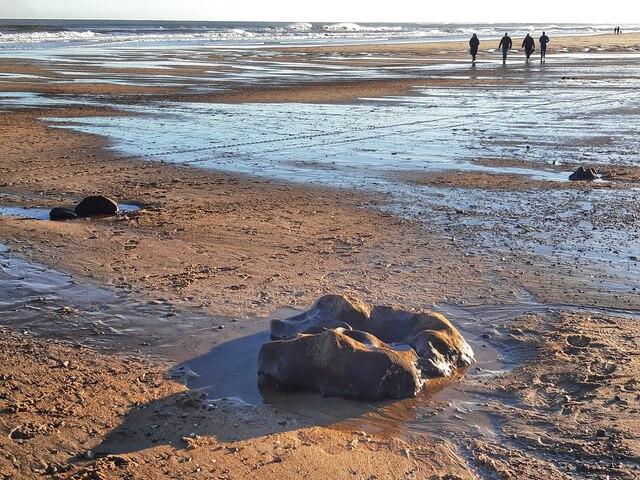
Storms at Cresswell, Northumberland, can expose the buried forest and peat of the landscape that once stood here. This is a modern shoreline photograph of an archaeological trace, not a view of Doggerland as it looked in the Mesolithic.

Pollen is one of the signals researchers read in sediment. This comparative public-domain micrograph explains the kind of archive; it is not a Doggerland sample.
Human use of the North Sea landscapes is visible in objects, human remains, animal bones and dietary signals recovered from the drowned basin. The evidence is scattered because ordinary homes, hearths and shorelines now lie beneath water and moving sediment.
Mesolithic human remains from the southern North Sea carry radiocarbon dates and stable isotope signatures. The isotope work points to increasing aquatic food in the regional record, a reminder that shore and inland were connected ways of living. [5]
A Late Glacial human parietal and a decorated bovid bone survive as intimate fragments. Organic material can endure under water in ways that it rarely does on an exposed, oxygenated land surface. These finds open a life without supplying a complete biography. [9]
The strongest image is a changing set of hunter-gatherer worlds, connected by rivers, wetlands, shorelines and seasonal movement, then compressed into the few traces that survived.
| Evidence | Can show | Needs caution | Status |
|---|---|---|---|
| Geophysics | buried valleys, basins and coastlines | strong for shape; indirect for daily life | method |
| Sediments | pollen, charcoal, fauna and sedaDNA | strong when local deposition is secure | evidence |
| Artefacts | tools, worked bone and organic objects | proof of activity; context often partial | evidence |
| Human remains | dates, isotopes and anatomy | human presence and diet; small sample | evidence |
| Ancient DNA | plants, animals and population movement | signal depends on time, place and preservation | evidence |
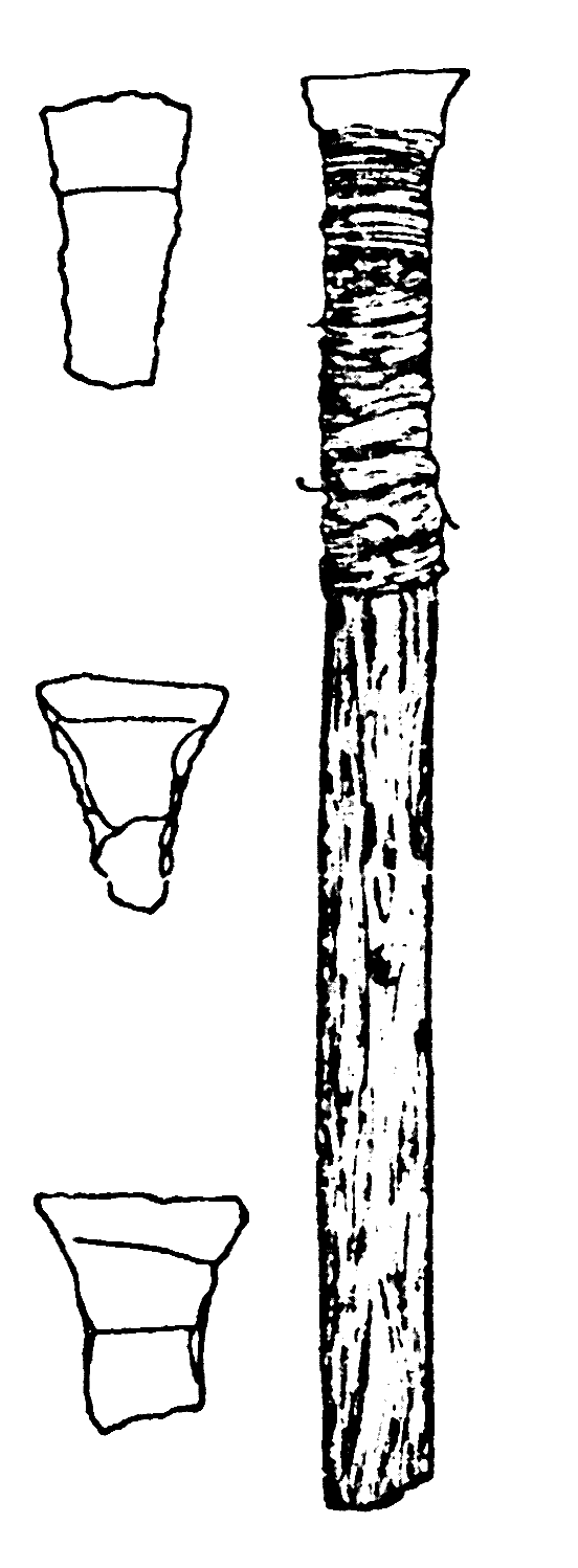
A comparative Mesolithic arrow drawing from Denmark. It is not a Doggerland find; it stands in for the kinds of fragile, purposeful objects the drowned landscape preserves only unevenly.
Genetic evidence enters Doggerland through several doors. Sedimentary ancient DNA can indicate the plants and animals present in a buried landscape. Ancient human genomes can reveal movement and mixture across later Britain. These records are powerful because they connect landscapes to populations, and limited because every sample belongs to a place, a time and a chain of preservation. [1]
Sedimentary ancient DNA can preserve fragments of the plants and animals that lived around a buried river. Its reach depends on how the sediment moved and settled.
A signal from sediment is evidence of an environment. A genome is evidence about an individual or population. Each becomes more useful when joined to archaeology, chronology and context.
Studies of later movement across Britain and the North Sea show why the region must be read as a layered history. Major Y-chromosome lineages expanded in recent prehistory; Early Neolithic and Bronze Age movement reshaped Britain; Anglo-Saxon-era mobility added another North Sea layer. These studies illuminate population history across time. They do not provide a single route back to Doggerland. [14] [15] [16] [17]
Doggerland is often presented as a clean animation: land, wave, disappearance. The evidence holds a longer sequence: environmental change, human presence, episodic shocks and uneven preservation. The dates below are anchors, not a single countdown.
Secure fine sediments from the Southern River preserve signals of oak, elm and hazel. The result points to a temperate refuge in a landscape long assumed to be more open and cold. [1]
As the last glacial world gives way to the Holocene, ice melt and land movement change the shape of the North Sea basin. Doggerland is not a fixed island waiting for one flood. It is a surface in motion. [6]
Sea-level rise fragments the plain, remakes river mouths and pushes people toward higher ground. The exact shape depends on which part of the basin and which reconstruction you mean. [2]
A submarine landslide off Norway generates a major wave. New work finds evidence in the southern North Sea while challenging the idea that one wave alone permanently finished Doggerland. [3]
By the late Mesolithic, the remaining lowlands are submerged. The date is not one clean line on a map: models, local basins and the 2026 sedaDNA study do not all resolve it in the same way. [1]
Cores, seismic profiles, dredged objects, human remains, isotopes and ancient DNA let us reconstruct a place that cannot be visited as land. The gaps are part of the story. [7]
This shelf is the evidence spine behind the explainer: primary studies first, then methods, context and population-history research. It does not claim to contain every publication ever written about the North Sea. It is a traceable starting corpus with the limits of each source left visible.
252 samples from 41 cores, the Southern River reconstruction, local versus reworked sedaDNA, temperate trees over 16,000 years ago and the microrefugium interpretation.
Why this source matters: This is an ecological reconstruction from sediment. It does not by itself prove a human settlement pattern or show that every part of Doggerland shared the same history.
Open source ↗Sea-level scenarios, changing land area, archaeological radiocarbon dates and the need to compare inundation models with occupation evidence.
Why this source matters: The result depends on palaeobathymetry, isostatic assumptions, chronology and how archaeological dates are treated. It is a model of changing possibilities, not a single photograph of the past.
Open source ↗The tsunami evidence from the southern North Sea and the argument for a three-stage history of gradual inundation rather than a simple one-wave ending.
Why this source matters: The impact was spatially uneven. Sediment evidence is patchy and the consequences for particular communities remain difficult to observe directly.
Open source ↗Why bathymetry and model scale change estimates of wave propagation and potential inundation.
Why this source matters: A numerical wave model is sensitive to the reconstructed coastline, seafloor and boundary conditions. It is evidence for a scenario, not a direct measurement of the whole event.
Open source ↗Radiocarbon dates and stable isotope evidence from Mesolithic human remains recovered from the southern North Sea, including the changing contribution of aquatic foods.
Why this source matters: The assemblage is small and recovered material is not a representative census of the people who lived across the whole drowned landscape.
Open source ↗The major early synthesis of the submerged Mesolithic landscape, its archaeological history, survey methods and limitations.
Why this source matters: The book predates the latest sedaDNA work and later revisions to inundation modelling. It remains foundational rather than final.
Open source ↗The vocabulary of river valleys, basins, headlands and other features reconstructed from geophysical data.
Why this source matters: The spatial detail is strongest where seismic and core data are available; the drowned landscape is not mapped with equal confidence everywhere.
Open source ↗How seismic reflection data, cores and archaeological information are combined to recover terrain that cannot be excavated in the ordinary way.
Why this source matters: Project pages summarize a research programme and its discoveries. Individual claims should be checked against the underlying papers and datasets.
Open source ↗Human and decorated faunal remains recovered from the North Sea and the importance of organic preservation in submerged contexts.
Why this source matters: Finds recovered from fishing or dredging are often separated from their original context. A remarkable object is evidence of a life, not a complete settlement map.
Open source ↗A multi-proxy example of reading palaeolandscape and environmental change from a single shallow core.
Why this source matters: One core can show a local sequence. It cannot stand in for the entire North Sea basin without comparison to other records.
Open source ↗Evidence that submerged North Sea cores preserve lake, clay, plant and invertebrate deposits from phases before the modern sea filled the basin.
Why this source matters: The north-eastern North Sea record is not identical to the southern Doggerland river systems. Regional histories must stay separate.
Open source ↗The research agenda connecting ancient DNA, isotopes, tools, animal remains and cultural change under a rising sea.
Why this source matters: This is a project overview. It points to a wider research programme rather than replacing each project publication.
Open source ↗The earlier catastrophic interpretation and the model tradition that treated Storegga as a possible abandonment trigger.
Why this source matters: Later work has challenged the idea that the wave alone permanently submerged all remaining Doggerland. The paper is included because the disagreement is part of the history of the field.
Open source ↗The finding that major European Y-chromosome lineages, including I1, can have relatively recent common ancestors and expansion histories.
Why this source matters: The study is a population-level model from present-day and ancient comparison data. It does not isolate the history of any single branch.
Open source ↗The major genetic shift associated with incoming continental farmers and the persistence of only small, structured Mesolithic ancestry in the sampled British Neolithic.
Why this source matters: Ancient DNA samples are uneven across time and geography. Population change does not erase every local line, and a result from one period cannot be projected unchanged into another.
Open source ↗The scale of later movement and ancestry change that makes any modern population a layered historical record.
Why this source matters: Later migration is context for population history, not a direct record of occupation in Mesolithic Doggerland.
Open source ↗A later example of substantial migration across the North Sea and why modern British ancestry cannot be read as a single ancient layer.
Why this source matters: The study concerns the first millennium CE, many thousands of years after Doggerland's inundation.
Open source ↗The methodological background to submerged prehistoric archaeology and the concept of Doggerland as a drowned landscape.
Why this source matters: A handbook chapter is a contextual guide. Current claims should be checked against newer primary studies.
Open source ↗The atlas tradition behind the map language, including the integration of spatial datasets and submerged depositional features.
Why this source matters: The atlas reflects the data and models available at publication. Its value is strongest when read as a research foundation.
Open source ↗Research cutoff: 13 August 2026. Review when the primary evidence or a major reconstruction materially changes.