The Living Fire at Lopătari: what burns on the hill and how much gas escapes in a year
On a slope in the Buzău Subcarpathians, Romania, gas seeps out of the ground and burns — 21.9–26.9 tonnes of methane a year, by two measurement campaigns. Drill 3,331 metres down after the gas, then set the flame beside your own home's use.
The Living Fire stands near Terca, Lopătari commune, in Buzău County, on the left bank of the Slănic valley.

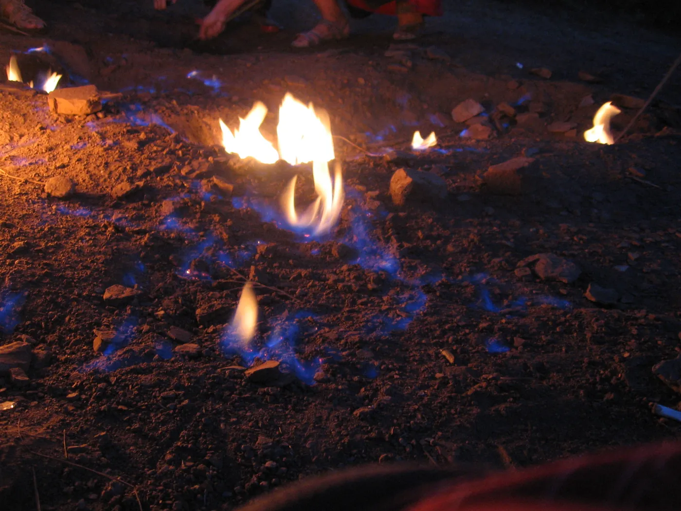
Blue and yellow flames on the seepage patch at night, with visitors' feet beside them for scale. Photo: Petr Sporer, 9 August 2018. (Photo: Wikimedia Commons, CC BY-SA 4.0)
The place
Four fires burn in the bend of the Carpathians — at Lopătari, Răiuți, Lepșa and Andreiașu — and the Lopătari one is the only fire measured twice, by two teams from the same laboratory, two years apart. The map comes down from the four fires to the patch on the slope.
The Carpathian bend
Four fires, one gas measured twice
The circles mark the four Carpathian fires where the methane output was measured: Lopătari, Răiuți, Lepșa and Andreiașu. The dots near Pâclele mark the mud volcanoes and the 2341 Berca well, the 3,330-metre-deep drilling whose gas analyses appear below, at depth.
Breazău slope, 843 metres
A slope above the Slănic, north-north-east of Terca
The fire burns on the western slope of the Breazău ridge, on the left side of the Slănic valley, at 843 metres of altitude on the relief model. The hill is Paleogene flysch — folded sandstones and marls of the Tarcău Nappe — and the gas rises through cracks, not through mud chimneys.
The 120 m² patch
A flat-sized patch, of which 35–38 square metres were measured
The whole seepage area covers about 120 m², by the geopark dossier (citing Baciu et al. 2018). Inside it, the two campaigns measured 14 flux-chamber points each, over 38 (2013) and 35 (2015) square metres. In 2015 two points read 5,533 and 70,570 grams per square metre per day — probably the vents of the area.
Flames about 50 cm high
Flames about half a metre high, never twice the same
The vents carry flames about 50 centimetres high. In the 2013 campaign the hottest point read 12.5 times the median — which is why no two visits look alike: move the flux chamber a metre and the number changes. Day-to-day variation appears in no paper read.
The descent
Nothing was ever drilled under the patch. So the column shows only what was measured: at the top, the patch at the surface; at the bottom, the gas analyses from the 2341 Berca well — the nearest deep drilling in the same hydrocarbon system, about 25 km to the south-east. Between them, the hatching says what is not known.
0 metres — the surface
The patch, seen from above
At zero metres: the roughly 120 m² of seepage, with the 14 measurement points of each campaign. Down from here, not one drilled metre exists at Lopătari — the column stays hatched down to the windows at depth.
The 2341 Berca well
The windows come from 25 km away
The 2341 Berca well, about one kilometre north-east of the Pâclele Mici reserve, reached 3,330 metres through Romanian, Pontian, Maeotian and Sarmatian strata (Voicu 1975). Its gas analyses — three intervals — are the only deep windows in the area. The Berca strata are not the Lopătari strata: so the column wears no lithology.
−2,601 metres
97.9% methane at 2,601–2,618 metres
The first analysed interval of the 2341 well: 97.9% methane, 1.5% ethane. The cleanest gas of the three windows. Its Bernard ratio — 54.4 — stands beside the Lopătari gas, 37.4.
−2,871 metres
95.0% methane at 2,871–2,877 metres
The second interval: 95.0% methane, 2.7% ethane, 0.66% propane. Its Bernard ratio, 28.3, is the closest to the Lopătari fire gas of any published deep gas.
−3,002…−3,331 metres
95.4% methane over the well's last 329 metres
The third interval joins the bottom of the well, from 3,002 to 3,331 metres: 95.4% methane. With 0.8% ethane and 0.14% propane, the Bernard ratio rises to 101.5 — a drier gas than the one burning on the hill.
About −3,000 metres
The Pâclele mud forms around 3,000 metres down
By Sencu 1985, the mud formation at Berca sits around 3,000 metres deep, in Middle Miocene deposits. The fire gas was born, by modelling, at 180–220 °C, from type III kerogen — land-derived organic matter, baked deep.
The gas
The gas burning on the hill was caught in vials and taken to the chromatograph. Here is what came out, by Frunzeti 2013, table 8.4.1 — the molecular composition in percent:
| Substance | Percent |
|---|---|
| Methane (C1) | 94.90 |
| Ethane (C2) | 1.80 |
| Propane (C3) | 0.74 |
| Isobutane (iC4) | 0.15 |
| n-butane (nC4) | 0.28 |
| Isopentane (iC5) | 0.102 |
| n-pentane (nC5) | 0.084 |
| Hexane and heavier (C6+) | 0.10 |
| Carbon dioxide | 0.40 |
| Nitrogen | 0.79 |
| Oxygen | 0.501 |
| Argon | 0.15 |
| Helium | 0.0040 |
| Hydrogen | below detection limit |
How wet the gas is
The Bernard ratio — methane divided by ethane plus propane — says how dry a gas is: the higher it comes out, the more of its heavies the gas lost on the way. The Lopătari gas gives 37.4. The Andreiașu gas gives 37.9 — nearly the same. The 2341 well gases give between 28.3 and 101.5. And the Pâclele Mici gas gives 891.8: an exhausted gas, fractionated by its journey through mud and water.
On the Bernard diagram in the Ionescu 2015 thesis, the three fires — Andreiașu, Răiuți, Lopătari — fall together, and the thesis says they could be tied to the same reservoir. “Could”: the reckoning here strengthens the likeness; it does not promote it to certainty.
The isotope fingerprint
The Lopătari methane carries δ13C of −32.29‰ and δD of −144.5‰, with ethane at −26.78‰ and propane at −26.51‰. Modelling places its formation at 180–220 °C, from type III kerogen, at a maturity of 2.0–2.5% Ro on one model and 1.4–1.6% Ro on another. Two models, one order-of-magnitude verdict: a deep-baked thermogenic gas, not a shallow microbial one.
The fire
The two campaigns give 21.9 and 26.9 tonnes of methane a year. The naive reckoning — the median of 1,265.3 grams per square metre per day, times the area — gives 17.5 tonnes: less, because the few strong vents carry most of it. The published band, 21–27 tonnes, is the honest one; the bars below carry it throughout.
Burned or vented
Burned, the methane becomes carbon dioxide: 62.4–76.6 tonnes a year, by the full composition of the gas. Vented, the same amount would warm like 1,807–2,219 tonnes of CO2e over 20 years and 653–802 tonnes over 100 years (the AR6 potentials for fossil methane: 82.5 and 29.8). So the flame cuts the warming about 29-fold over 20 years and about 10-fold over a century (29.0 and 10.5 exactly, in the reckoning). The fire is the lesser evil.
Independent check: the IPCC factor of 56,100 kg of CO2 per TJ, applied to the energy of the gas, gives 62.1–76.3 tonnes — within 0.5% of the stoichiometry. The reckoning is done twice, by two routes.
Why it never goes out
Because the gas keeps coming. The two campaigns, two years apart, both found strong vents in the same patch — 15,794 grams per square metre per day in 2013, 70,570 in 2015. A flame may blink or drop in the wind, but the seepage was never caught without gas where the vents burn. While gas rises, the fire has something to burn.
Your home
The flame gives 307.7–377.9 MWh a year — 35.1–43.1 kW without pause, like a flat's combi boiler left running. Pick a use or type the one on your bill, and the page shows every how many days the hill burns your home's gas for a whole year.
The flame: 35.1–43.1 kW without pause.
The band comes from the two campaigns: 307.7–377.9 MWh a year, by the IPCC calorific value of 48.0 MJ per kg. The check route — 50.0 MJ per kg on the methane mass — gives 304–373 MWh, 1.2% away.
What you type goes nowhere.
Is it safe?
Focul Viu is a nature monument, IUCN category III, in the Ținutul Buzăului UNESCO Global Geopark. No separate official guidance for visiting it was found in the research session — the page says only what the official position says: it is a protected area, under its responsible-visiting regime.
What the measurements say, with no advice added: an open flame on a high-intensity seepage of about 120 m², with vents where the flux jumps 12 times over the average. Going up means an unmarked trail, about 7 km of dirt road from Lopătari and a footbridge over the Slănic — by the public access description, not verified on the ground here.
The day to go
Go up on a dry day, in boots, with time to return by daylight: the patch is small and easy to miss. Take your home figure with you — every how many days the hill burns your yearly gas — and look at the vents with it in mind.

Sources and method
- The gas: the molecular and isotope composition comes from Frunzeti 2013 (the PhD thesis summary, UBB Cluj), tables 8.4.1–8.4.2 — original measurements, on a Shimadzu chromatograph, 2% accuracy.
- The output: 21.9 tonnes a year (Frunzeti 2013, 38 m², 14 points) and 26.9 tonnes a year (Ionescu 2015, 35 m², 14 points). The naive reckoning from the median gives 17.5 tonnes; the page carries the published band, 21–27 tonnes.
- The depths: the analyses from the 2,601–2,618, 2,871–2,877 and 3,002–3,331 metres come from the 2341 Berca well (Filipescu & Humă 1979, via Brustur et al. 2015); the 3,000-metre mark from Sencu 1985; the 180–220 °C formation temperature from Ionescu 2015.
- The climate: the warming potentials 82.5 (20 years) and 29.8 (100 years) are the AR6 fossil-methane ones, table 7.15. Over 100 years the table already includes the CO2 from oxidising the methane.
- The energy: 48.0 MJ per kg is the IPCC 2006 net calorific value for natural gas (table 1.2), applied to the seep mixture; the check on 50.0 MJ per kg of methane lands 1.2% away.
- The 843-metre altitude is read off the relief model at the page coordinate; a secondary figure of about 1,030 metres proved tied to a rounded coordinate 1.4 km off-site — it is not used.
- What is not known: the national act declaring the monument (the text of Law 5/2000 could not be opened in session), the seasonal variation of the flames, and any separate official visiting guidance for the site.
| Interval (metres) | Methane % |
|---|---|
| 2,601–2,618 | 97.9 |
| 2,871–2,877 | 95.0 |
| 3,002–3,331 | 95.4 |
What the map shows
Four fires burn in the bend of the Carpathians — at Lopătari, Răiuți, Lepșa and Andreiașu — and the Lopătari one is the only fire measured twice, by two teams from the same laboratory, two years apart. The map comes down from the four fires to the patch on the slope. The column is hatched wherever Lopătari was never drilled. The figured depths come from the 2341 Berca well (Filipescu & Humă 1979, via Brustur et al. 2015); the 3,000-metre mark from Sencu 1985; the formation temperature from Ionescu 2015.
- Focul Viu, Lopătari — 21.9–26.9 tonnes of methane a year, by the two campaigns.
- Near Andreiașu de Jos — 38–54 tonnes a year, by the two campaigns.
- Near Răiuți — 8–17 tonnes a year, by the two campaigns.
- Near Lepșa — about 1.5 tonnes a year.
- Pâclele Mari — 730 tonnes a year (Baciu et al. 2007).
- Pâclele Mici — 383 tonnes a year (Baciu et al. 2007).
- The 2341 Berca well — 3,330 metres, gas analyses at depth.
Gas and output
- N. Frunzeti, “Geogenic greenhouse gas emissions in the southern part of Eastern Carpathians” — PhD thesis summary, UBB Cluj-Napoca, 2013, coord. C. Baciu. teze.doctorat.ubbcluj.ro
- A. Ionescu, “Geogenic methane in petroliferous and geothermal areas in Romania: origin and emission to the atmosphere”, PhD thesis, UBB Cluj-Napoca, 2015, coord. C. Baciu. teze.doctorat.ubbcluj.ro
- A. Ionescu, P. Burrato, C. Baciu, G. Etiope, B.-M. Kis, “Inventory of Onshore Hydrocarbon Seeps in Romania (HYSED-RO Database)”, Geosciences 7(2), 39, 2017. doi.org
Geology and place
- T. Brustur et al., “The mud volcanoes from Berca: a significant geological patrimony site of the Buzău Land Geopark (Romania)”, Geo-Eco-Marina 21, 2015. geoecomar.ro
- M. C. Melinte-Dobrinescu et al., “Geological investigations and mapping in the Buzău Land Geopark: state of the art”, Geo-Eco-Marina 23, 2017. geoecomar.ro
- “Buzău Land Aspiring UNESCO Global Geopark — Application Dossier (public file)”, Ținutul Buzăului. tinutulbuzaului.org
Climate and energy
- 2006 IPCC Guidelines, vol. 2, ch. 1, tables 1.2 (48.0 MJ/kg) and 1.4 (56,100 kg CO2/TJ). ipcc-nggip.iges.or.jp
- IPCC AR6, WG1, ch. 7, table 7.15: fossil methane GWP20 82.5 / GWP100 29.8 (the FfE München table). ffe.de
Data and map
- Relief: AWS Terrain Tiles (Terrarium, SRTM-based). Coordinates: the geopark dossier and Nominatim (© OpenStreetMap contributors, ODbL). Photos: Wikimedia Commons, licences with each image.
See also: the Berca mud volcanoes — the same county, a different mechanism: gas with mud and water, not a dry flame; the Colți amber — the same Tarcău Nappe, another Oligocene story.