Century-Old Romanian Photographs in 3D: Where the Tripod Stood and What Still Stands
Every old photograph also records where the photographer stood. Each of these 8 interwar photographs has been matched, landmark by landmark, to today’s terrain and buildings, which puts the camera back on the map. Test each photograph by leaving landmarks out of the fit, and the median of the 8 resulting errors is 0.51°. Drag the curtain to lay 1930s Romania over 2026, or step off the tripod and walk around the view.
8calibrated interwar plates
7places in 6 counties and Bucharest, 3 regions
0.51°median held-out error (22.8 px)
4with 2020s ground witness
Share this page
Hold the 1930s glass plate over 2026 Romania
1930s / 2026
—
LMI / HeritageOSM height9 m unmeasured
Seen from any other angle, the photograph is projected from the reconstructed camera position onto today’s terrain and buildings. Where it stretches or tears, the place may have changed, today’s map may lack or approximate the height of what stands there, or the terrain model may be too coarse. With “Errors ×5” on, each line runs from where the reconstructed camera places a landmark to where the photograph shows it, drawn five times longer than it is.
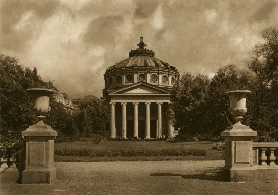
01 · Romanian Athenaeum, Bucharest · 1933
Romanian Athenaeum before the Palace Square redevelopment
Kurt Hielscher sets his tripod in the garden west of the Romanian Athenaeum in the early 1930s, framing the six Ionic columns and central cupola. While low buildings surrounding the square were later redeveloped, the Athenaeum (heritage B-II-m-A-18789) stands intact, and 2020s street views confirm the alignment along the garden walk.
Kurt Hielscherazimuth 48° · 36° FOVOSM 78.8%test error 0.31°
02 · Cetățuia Hill toward Elizabeth Bridge & City Hall, Cluj-Napoca · 1931
View from Cetățuia Hill across Elizabeth Bridge toward City Hall and Bob Church
From the Cetățuia hillside in 1931, this Fortepan plate spans the Someșul Mic valley from Elizabeth Bridge in the foreground across Iulian Pop Street to Bob Church spire and Cluj City Hall's cupola. Inside the solved viewing cone, postwar blocks—including the 25.8 m riverside tower—now reshape the right-bank skyline.
Ion Ghica Street toward the Stock Exchange Palace and National Bank
Iosif Berman shot Ion Ghica Street with a rising-front view camera, keeping verticals parallel between the stepped modernist block on the left (today Spiru Haret University) and the Neo-Baroque Stock Exchange Palace. Fixing horizontal optical center (cx = 0.50) stabilizes the vertical lens-shift recovery.
Someșul Mare Valley at Șanț beneath the Rodna Ridge
During the 1935 Bucharest Sociological School campaign, Iosif Berman climbed the southeastern slope above Șanț (~880 m elevation) looking WNW across the Someșul Mare valley. The village church and Cobășel valley bridges lock simultaneously with the full Măgura–Curățel–Rabla ridge in Copernicus GLO-30 (max ridge residual 19.8 px).
Assumption Church in Drăguș during the 1929 monograph
Photographed by Iosif Berman during the 1929 Drăguș sociological monograph, the village church stands unchanged at ~1° held-out accuracy across its porch, transept, and apse—while the 1929 peasant cottage in the left foreground no longer matches the narrower modern OSM footprint.
Across the lake and framed by park trees, Kurt Hielscher photographed the Brâncovenesc loggia of Mogoșoaia Palace (heritage IF-II-a-A-15298) in 1933. Calibration places the tripod on the western shore at 0.34° (8.3 px) median held-out error, confirming that the main wing and corner pavilions preserve their exact 1933 massing.
Kurt Hielscherazimuth 76° · 25° FOVOSM 0.0%test error 0.34°
07 · Comana Monastery, Giurgiu · 1933
Comana Monastery above the Neajlov marshes
Hielscher’s 1933 plate captures the fortified walls of Comana Monastery (heritage GR-II-a-A-14967) reflected in the Neajlov waters. Calibration across 11 landmarks on the enclosure walls and church spires achieves 0.65° median held-out error; the historic monastic enclosure endures intact amid denser wetland woodland.
Kurt Hielscherazimuth 31° · 27° FOVOSM 0.0%test error 0.65°
08 · Piața Unirii (Union Square), Timișoara · April 1937
The Roman Catholic Cathedral and the Plague Column, April 1937
The archive caption says “Serbian church”, but the building in frame is the Roman Catholic Cathedral on the east side of the square (heritage code TM-II-m-A-06176), with its two onion-domed towers and vaulted porch. The calibration puts the tripod on the cobbles about 90 m from the facade, and the base of the Plague Column on the right lands within a pixel of its outline in OpenStreetMap. Cathedral and column stand where they stood; the sources consulted do not establish what became of the low houses on the left or the J. Koch shop.
A plate can be placed only where today’s maps record enough of what it shows: building corners, heights, ruins. For 13 of these plates the specific gap is known and listed below. Most are ordinary public-data gaps, such as a church or a bank with no recorded height, which anyone can fill in OpenStreetMap.
Each archival plate is fitted in local East-North-Up metres using Copernicus GLO-30 ridges and surveyed OpenStreetMap corners. Vertical rising-front shifts are constrained unless at least 10 landmarks span depth, and accuracy is measured on landmarks held out of the fit, two at a time. Șanț is scored more strictly: most of its landmarks are mountain skyline points, which tend to agree with each other, so for the test a second camera fit uses the skyline alone, and its error (0.57°) is measured on the church and bridges that fit never saw.
DSM vs bare earth & OSM completeness
Copernicus GLO-30 is a Digital Surface Model (DSM) that includes modern roofs and forest canopies. Where OpenStreetMap lacks building height or floor-level tags (11.3% average across 1164 cone buildings), unmeasured volumes render as translucent 9 m placeholders rather than solid masonry.
Independent EXIF benchmark check
Tested separately against modern GPS+EXIF street scenes (excluded from the 1925–1937 archive counts):
Archival plates (1925–1937): Kurt Hielscher (1933, Public Domain), Iosif Berman (Wikimedia Commons Public Domain & Muzeul Național al Satului „Dimitrie Gusti” via Europeana/Culturalia, CC BY-SA 4.0), Willy Pragher (1934–1937, Landesarchiv Baden-Württemberg, CC BY 3.0 / CC BY 4.0), Fortepan (CC BY-SA 3.0). Only collections in the public domain or under verified open licences (CC BY / CC BY-SA) are included; photographers still within the 70-year EU/Romanian post-mortem term were excluded during intake.
Elevation & 3D buildings: Copernicus DEM GLO-30 (European Space Agency / Sinergise, CC BY 4.0); OpenStreetMap contributors (ODbL, 2026-10-30 extract).