Chapter 4 · Landforms: the base on which human society develops
How do you read a mountain on a map, and what gave it its shape?
Clock: ten thousand yearsScale: from 2,544 m down to sea level
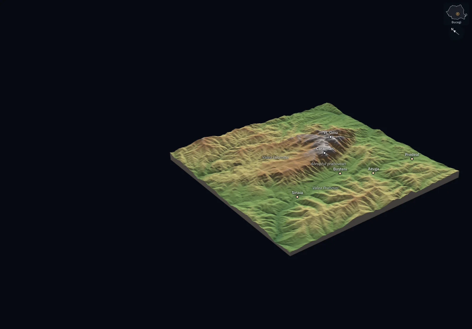
The block beside you is a piece of the Bucegi Mountains, 27 km on a side: the summit of Vârful Omu, the plateau, the escarpment above the Prahova Valley and the Ialomița Valley. Every point of it has an altitude measured from satellite, and the heights are drawn at true scale. On a map, the same mountain is made of lines alone; the block shows where they come from.
On the map, two lines have the same length
The map shows the Bucegi from above, around the town of Bușteni. The brown lines are contour lines. The orange line and the blue line each measure 3 km on the map.
On which of them is the climb harder?
A horizontal plane cuts the mountain at 1,500 m
A horizontal plane has risen through the block and stopped at an altitude of 1,500 m. Everything higher sticks out above it.
The yellow line is where the plane touches the ground. All its points are at the same altitude: it is a contour line.
At 1,000 m the line follows the foot of the mountain and runs deep into the valleys. At 2,000 m it circles only the high part.
Where contour lines are close together, the slope is steep
The plane has risen above the summit and left a line every 100 m: 19 contour lines, from 700 m to 2,500 m. The difference in altitude between two neighbouring contour lines is the contour interval; here it is 100 m. The thick lines mark every 500 m.
On the escarpment above the Prahova Valley, the contour lines lie pressed against each other: the ground climbs 100 m over a short distance. On the plateau they are far apart: you walk a long way to the next hundred metres.
Seen from above, the block becomes a map
The block has been flattened and the view has risen straight above it. The shadows are gone, the contour lines stay where they were: this is the contour map of the Bucegi.
Contour lines that close inside one another, higher towards the inside, mark a summit. That is how Vârful Omu appears, at 2,505 m on Romanian maps and at 2,506 m in the model used here. Valleys are recognised by contour lines that enter the mountain in a V, with the point towards the source.
Cut from A to B, the orange line climbs 6.5 times as much
The block has been cut vertically along the orange line. The upper edge of the cut is the profile: it shows how the ground rises from A to B.
On the orange line, point B is 1,457 m higher than point A, over 3 km of horizontal distance. The mean slope between the ends is 1,457 : 3,000 × 100 = 49%, an angle of 26°. On the blue line, B is 225 m higher than A, over the same distance: 7.5%, or 4.3°. The mean slope compares only the two ends; between them, the ground can climb and drop.
On the map, the lengths were equal. The contour lines showed the difference: the orange line crosses 14 contour lines, the blue one four contour lines.
Heights drawn double do not change the measured slope
The cut now runs from west to east, over 9.4 km: it drops into the Ialomița Valley, climbs onto the plateau near Babele and falls down the escarpment to Bușteni. At true scale, a 2,500 m mountain spread over 27 km looks low, so many blocks and profiles in textbooks have their heights enlarged.
Here the heights are drawn twice as large, and under the block it says “heights 2×”. The mountain looks steeper, but the measurements are unchanged: point B is 850 m lower than point A, and the mean slope between the ends is still 9.1%. Between A and B the ground climbs and drops; the mean does not show the slope of each stretch.
When you read a profile, first look for how many times the heights have been enlarged.
Other landforms, other patterns of contour lines
Padiș, Apuseni Mountains. On the limestone plateau, contour lines close around hollows; on a printed map, their values fall towards the inside. These are closed depressions, coloured blue here: water that enters them has no way out at the surface and leaves underground. The largest, around Cetățile Ponorului, has its floor at 1,001 m, 161 m below the lowest point of its rim.
Bâlea – Capra, Făgăraș Mountains. Below the ridge, contour lines draw bowls open on one side: glacial cirques, like the one that holds Lake Bâlea (2,034 m; in the model, 2,032 m). Lower down, the profile across the Bâlea Valley has its floor at 1,700 m and walls that rise more than 300 m on each side: the shape of a U, left by a glacier.
Towns sit on the valley floors, below 1,100 m
The light-coloured dots are the towns and villages in the block, from OpenStreetMap. Sinaia, Bușteni, Azuga and Predeal string along the Prahova Valley, between 814 m and 1,035 m. On the other side of the mountain, Bran and Moieciu lie at its foot.
No settlement in the block goes above 1,100 m, although 73% of its area lies higher. On the valley floor and the low terraces beside the river, the ground is almost flat, water is at hand, and the road and the railway follow the valley.
The escarpment is too steep for houses. The plateau is flat, but hard to reach and cold.
Now you explain
The map shows the Făgăraș ridge between the Bâlea Valley, to the north, and the Capra Valley, to the south. The line from A to B crosses it from north to south.
Read only the contour lines: on which side of the ridge is the slope steeper along the line? Where would you look for an almost flat spot for a mountain shelter, and why would you not put it below a slope with very close contour lines?
Compare with an answer
Along the line, the southern slope, towards the Capra Valley, is steeper: its average gradient up to the ridge is 36%, against 19% on the other side, and the contour lines are closer together there. An almost flat spot is recognised by widely spaced contour lines: a flat terrace in the valley or the floor of a glacial cirque. Below a slope with very close contour lines, the steep gradient brings avalanches and falling rocks.
Lesson 4.4: the landforms around you, read on a map
Lesson 4.3: river, coastal and karst landforms