Chapter 7 · Life and soilLesson 7.2
Earth’s biogeographic zones and mountain vegetation belts
Why does a journey from the Equator to the North Pole pass through almost the same kinds of vegetation as a climb from a plain to a Carpathian summit?
Before you read: what do you think?
Where do you think less rain and snow falls in a year: in the tundra beside the Arctic Ocean or in a tropical desert such as the Sahara?
See the answer
About the same: at most roughly 250 mm. The tundra receives only 150–250 mm of precipitation a year, and a tropical desert at most roughly 250 mm. Temperature sets them apart: in the tundra, summer is too short for trees and the ground remains frozen deep down all year.
In Manaus, in the heart of Amazonia, 2,323 mm of rain falls in a year, and every month averages 27–28 °C. A desert gets almost ten times less rain, while winter temperatures in the tundra fall to −40 °C. Between these extremes, vegetation forms broad bands that follow the climate.
Biogeographic zones follow the climate
On a journey from the Equator towards the North Pole, evergreen forest gives way to savanna, then desert, forests that shed their leaves in autumn, coniferous forests and, finally, treeless tundra. On a high mountain in the Carpathians, the same order appears from foot to summit: deciduous forests, coniferous forests, low grasslands. In both cases, the cause is falling temperature.
A biogeographic zone is a broad stretch of land with the same climate, vegetation and wildlife. The zones follow one another from the Equator towards the poles, because temperature falls in that direction. Within each climate zone, water decides what grows: forest where rain is plentiful, grasses where it is scarce, desert where it hardly rains.
The hot zone: equatorial forest, savanna, tropical desert
Equatorial forest grows in Amazonia, the Congo River basin and Indonesia. It is hot all year and rainfall is between 2,000 and 10,000 mm a year. The forest is evergreen and dense, with trees on several levels, lianas and orchids.
Savanna stretches out on either side of the equatorial forest, especially in Africa. The year has a rainy season and a dry season. Its vegetation consists of tall grasses and scattered trees, such as baobabs and acacias. It is home to large herbivores – zebras, antelopes, giraffes and elephants – and their predators, lions and cheetahs.
Tropical deserts, such as the Sahara, the Kalahari and the deserts of Australia, receive at most roughly 250 mm of precipitation a year. Days are very hot and nights turn sharply colder. Plants are sparse and adapted to dryness: cacti, thorny bushes and date palms in oases.
For the curious
Equatorial forests are home to monkeys, parrots, jaguars, snakes and huge numbers of insects.
In the desert, camels, snakes, scorpions and desert foxes can go for long periods without water.
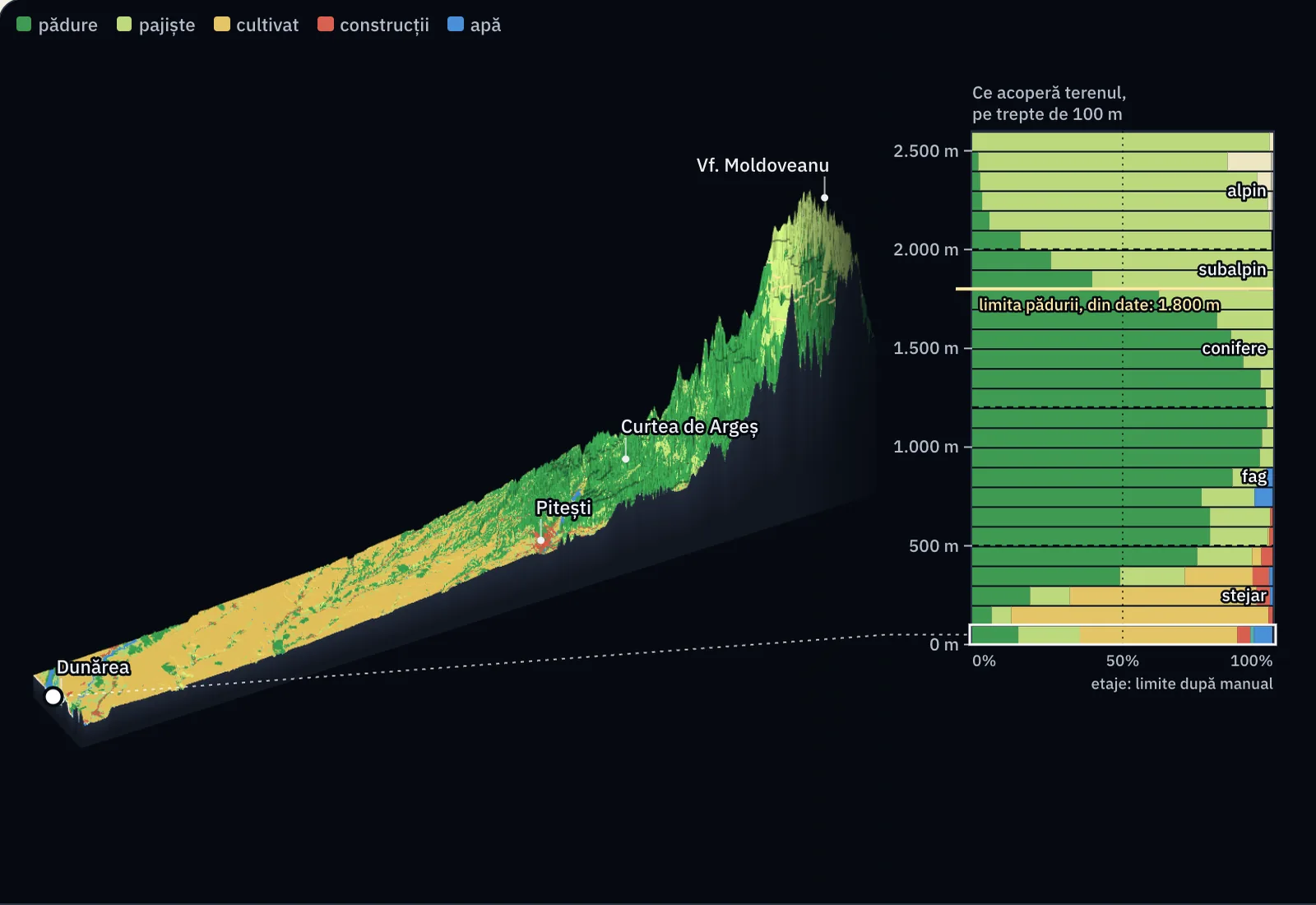
| Altitude | Area, km² | Forest | Grassland | Cropland | Other |
|---|---|---|---|---|---|
| 0–100 m | 635 | 15.3% | 20.5% | 52.3% | 11.9% |
| 100–200 m | 1568 | 6.4% | 6.6% | 85.4% | 1.6% |
| 200–300 m | 667 | 19.2% | 13.2% | 62.0% | 5.5% |
| 300–400 m | 494 | 49.1% | 21.6% | 22.5% | 6.9% |
| 400–500 m | 388 | 74.8% | 18.2% | 3.1% | 3.9% |
| 500–600 m | 302 | 79.0% | 19.2% | 0.6% | 1.2% |
| 600–700 m | 140 | 79.0% | 20.1% | 0.2% | 0.8% |
| 700–800 m | 93 | 76.2% | 17.6% | 0.1% | 6.1% |
| 800–900 m | 92 | 86.5% | 11.2% | 0.0% | 2.3% |
| 900–1,000 m | 87 | 95.5% | 4.4% | 0.0% | 0.0% |
| 1,000–1,100 m | 82 | 96.3% | 3.7% | 0.0% | 0.0% |
| 1,100–1,200 m | 71 | 98.0% | 2.0% | 0.0% | 0.0% |
| 1,200–1,300 m | 70 | 97.5% | 2.5% | 0.0% | 0.0% |
| 1,300–1,400 m | 71 | 95.8% | 4.2% | 0.0% | 0.0% |
| 1,400–1,500 m | 70 | 90.0% | 9.9% | 0.0% | 0.0% |
| 1,500–1,600 m | 67 | 86.0% | 14.0% | 0.0% | 0.0% |
| 1,600–1,700 m | 63 | 81.3% | 18.6% | 0.0% | 0.1% |
| 1,700–1,800 m | 57 | 62.1% | 37.9% | 0.0% | 0.0% |
| 1,800–1,900 m | 51 | 39.9% | 60.1% | 0.0% | 0.1% |
| 1,900–2,000 m | 46 | 26.1% | 73.7% | 0.0% | 0.1% |
| 2,000–2,100 m | 40 | 16.0% | 83.3% | 0.0% | 0.6% |
| 2,100–2,200 m | 35 | 5.7% | 93.1% | 0.0% | 1.2% |
| 2,200–2,300 m | 24 | 3.3% | 94.9% | 0.0% | 1.8% |
| 2,300–2,400 m | 12 | 2.6% | 92.2% | 0.0% | 5.2% |
| 2,400–2,500 m | 2.2 | 2.0% | 82.8% | 0.0% | 15.1% |
| 2,500–2,600 m | 0.0 | 0.0% | 98.8% | 0.0% | 1.2% |
Measurements and calculation. The relief is the Copernicus GLO-30 model, and the colours are the classes of the ESA WorldCover 2021 map (10 m), brought to cells of 80 m. The bars show how much of each 100 m altitude band each class occupies in the strip of 24 × 218 km; the forest limit is the altitude at which trees fall below half of the strip's land. The temperature is calculated from altitude: 11.8 °C at 82 m, minus 6.5 °C for every 1,000 m. The names of the belts and the dotted limits are those of textbooks. Heights are exaggerated against distances wherever the image says so. The relief model, with 30 m cells, gives 2,517 m for Moldoveanu Peak; the official height is 2,544 m. The soil profiles are a drawing.
The temperate zone: from olive trees to taiga
Mediterranean vegetation grows around the Mediterranean Sea and in other regions with hot, dry summers and mild, rainy winters. It consists of evergreen shrubs and trees with small, tough leaves: olive trees, cork oaks, oleander, rosemary and thyme.
Deciduous forests cover western and central Europe, eastern North America and eastern Asia. The climate has four seasons and 750–1,500 mm of precipitation a year. Oaks, beeches, hornbeams and limes shed their leaves in autumn.
The steppe of Eurasia and the prairie of North America occur in continental interiors, where there is too little rain for forest. The vegetation consists of grasses. Steppe soils are very fertile, so most of the steppe is now cultivated.
Coniferous forest, called taiga in Siberia, forms a belt across northern Europe, Asia and North America. Winters are long and freezing, summers short, and precipitation is 300–900 mm a year. Spruce, pine, fir and larch have needle-shaped leaves that withstand the cold.
For the curious
Deciduous forest wildlife includes red deer, roe deer, wild boar, wolves, foxes and brown bears.
Rodents, saiga antelopes, bison and birds of prey live on the steppe and prairie.
Typical coniferous forest animals include moose, brown bears, lynx, wolves and sables.
The cold zone: tundra and polar desert
Tundra borders the Arctic Ocean. Temperatures range from −40 °C in winter to at most 18 °C in summer, and precipitation is only 150–250 mm a year. Trees are absent because summer is too short and the ground remains frozen deep down all year. Mosses, lichens, grasses and dwarf shrubs grow here. Reindeer, Arctic foxes, lemmings and, in summer, many migratory birds live here.
Polar desert extends across Antarctica, Greenland and the Arctic islands. Most of it is covered in ice all year, and plants are almost absent. Animals get their food from the sea: polar bears and seals in the Arctic, penguins in Antarctica.
On mountains, the zones repeat vertically
Temperature also falls with altitude. That is why, on a high mountain, vegetation changes from foot to summit in bands called vegetation belts. This pattern is called altitudinal zonation. The climb resembles a journey north: first deciduous forests, then coniferous forests, then grasslands like those of the tundra.
The resemblance has a limit. On a mountain, day length and the seasons remain those of its latitude. A high summit near the Equator has snow, but no polar night.
For the curious
The boundaries between belts vary from one mountain to another: the closer a mountain is to the Equator, the higher the belts reach.
Worked example
Vegetation on the climb up Peleaga
In Retezat National Park, beech forests grow between 800 and 1,200 m, mixed forests (beech with fir and spruce) between 1,200 and 1,400 m, and spruce forests between 1,400 and 1,800 m. The upper forest limit lies at an average of 1,800 m. Above it, mountain pine thickets reach 2,000–2,200 m. the summit of Peleaga is 2,509 m high.
A route starting at 1,000 m passes through beech forest (at 1,000 m), mixed forest (at 1,300 m), spruce forest (at 1,600 m), mountain pine (at 1,900 m) and alpine grassland with rocky ground (at 2,300 m).
the summit of Peleaga is 2,509 − 1,800 = 709 m above the upper forest limit. No shrubs grow on the last 300–500 m of the climb.
In Romania
Five belts from hills to ridge
Romania lies in the deciduous forest zone and, in the south-east, in Bărăgan and Dobrogea, in the steppe and forest-steppe zone, now almost entirely cultivated. In the Carpathians, vegetation forms belts. Romanian textbooks give the following average limits:
The oak belt reaches about 500 m, across low hills, plateaux and high plains, with oak, Turkey oak, Hungarian oak and lime. The beech belt extends from 500 to 1,200 m. The conifer belt, with spruce and fir, occupies mountains between 1,200 and 1,800 m. The subalpine belt, between 1,800 and 2,000 m, has thickets of mountain pine and juniper. The alpine belt, above 2,000 m, has only grasslands of short grasses.
Actual boundaries differ from these rounded values. In Retezat, beech starts at 800 m and mountain pine reaches 2,200 m. The alpine belt occurs only in the highest mountain massifs: Făgăraș, Retezat, Parâng, Bucegi and Rodnei.
In brief
- Biogeographic zones follow one another from the Equator to the poles according to temperature and precipitation: equatorial forest, savanna, tropical desert, Mediterranean vegetation, deciduous forests, steppe and prairie, coniferous forest (taiga), tundra, polar desert.
- In the hot zone, water makes the difference: equatorial forest grows where it rains all year, savanna where there is a dry season, and desert where at most 250 mm falls a year.
- In the temperate zone, deciduous trees grow in climates with four seasons and enough rain, steppe in dry continental interiors, and taiga in the north with its long, freezing winters.
- Trees are absent from the tundra because summer is short and the ground remains frozen deep down; mosses, lichens and dwarf shrubs grow there.
- Altitudinal zonation is the change in vegetation from mountain foot to summit as temperature falls with altitude.
- In the Carpathians: the oak belt (up to 500 m), beech (500–1,200 m), conifers (1,200–1,800 m), subalpine with mountain pine (1,800–2,000 m) and alpine (above 2,000 m).
Common mistakes
WrongAll hot places have the same vegetation because vegetation depends on temperature.
RightThe hot zone contains equatorial forest, savanna and desert. Temperatures are similar; the difference comes from the amount of rain and how it is distributed through the year.
WrongA desert means sand and extreme heat all the time.
RightA desert is a place with very little precipitation. Tropical deserts cool sharply at night, and Antarctica is an ice-covered polar desert.
WrongClimbing a mountain is exactly the same as travelling towards the North Pole.
RightThe fall in temperature and, therefore, the order of vegetation are similar. Day length and the seasons remain those of the mountain’s latitude.
Test yourself
Six questions. For the first five you see the explanation at once, with the paragraph of the lesson that supports it; for the ones with a written answer you compare with a good answer.
In which biogeographic zone do reindeer, Arctic foxes and lemmings live?
Answer
c) Tundra. Reindeer, Arctic foxes and lemmings are typical animals of the tundra, the treeless zone beside the Arctic Ocean.
Why do trees not grow in the tundra?
Answer
b) Because summer is short and the ground remains frozen. Tree roots cannot penetrate the frozen ground, and the short summer is not long enough for trees to grow.
Tall grasses, scattered trees such as baobabs and acacias, a rainy season and a dry season. Which zone is this?
Answer
a) Savanna. Savanna has tall grasses and scattered trees. Steppe has only grasses and lies in the temperate zone.
Which vegetation belt would you find at an altitude of 1,500 m in the Carpathians, using the average textbook limits?
Answer
d) Conifer belt. 1,500 m lies between 1,200 and 1,800 m, in the belt of spruce and fir forests.
The upper forest limit in Retezat is, on average, at 1,800 m. the summit of Peleaga is 2,509 m high. How many metres above the forest limit is the summit?
mAnswer
709 m. 2,509 − 1,800 = 709 m.
A very high mountain near the Equator has equatorial forest at its foot and snow on its summit. Explain why and say how its summit differs from a polar region.
A good answer
Temperature falls with altitude, so mountain vegetation changes in belts, from forest at the foot to grasslands and snow on the summit. This is altitudinal zonation. The summit differs from a polar region in day length and seasons: near the Equator, day and night are close in length all year, with no polar day or polar night.
A complete answer names the fall in temperature with altitude and altitudinal zonation, then explains the limit of the resemblance: day length and seasons depend on latitude.
Terms
- biogeographic zone
- A broad stretch of land with the same climate, vegetation and wildlife.
- savanna
- A zone in hot regions with a rainy season and a dry season, tall grasses and scattered trees.
- steppe
- A grassland zone in temperate continental interiors, where there is too little rain for forest; in North America it is called prairie.
- taiga
- The coniferous forest of northern Europe, Asia and North America, with long, freezing winters.
- tundra
- A treeless zone beside the Arctic Ocean, with mosses, lichens and dwarf shrubs on ground frozen deep down.
- altitudinal zonation
- The change in vegetation in bands (belts) from the foot of a mountain towards its summit, caused by falling temperature with altitude.
- mountain pine
- A low-growing pine with creeping stems, forming thickets in the subalpine belt of the Carpathians.
Sources and link to the programme
- NASA Earth Observatory – Biome: Rainforest – equatorial forest: 2,000–10,000 mm a year; Manaus: 2,323 mm a year, monthly averages of 27–28 °C
- NASA Earth Observatory – Biome: Desert – desert: roughly 250 mm of precipitation a year, very hot days and cold nights
- NASA Earth Observatory – Biome: Shrubland – Mediterranean-type vegetation: hot, dry summers, cool, wet winters, aromatic plants
- NASA Earth Observatory – Biome: Temperate Deciduous Forest – deciduous forests: 750–1,500 mm a year, four seasons, oak, beech
- NASA Earth Observatory – Biome: Grassland – steppe, prairie and savanna as grassland zones; their distribution
- NASA Earth Observatory – Biome: Coniferous Forest – coniferous forest: 300–900 mm a year, long, cold winters
- NASA Earth Observatory – Biome: Tundra – tundra: between −40 °C and 18 °C, 150–250 mm a year, no trees because of the short season and frozen ground
- Administrația Parcului Național Retezat – Habitate – beech forests at 800–1,200 m, mixed forest at 1,200–1,400 m, spruce forests at 1,400–1,800 m, forest limit at 1,800 m, mountain pine thickets up to 2,000–2,200 m
- Administrația Parcului Național Retezat – Scurt istoric – altitude of the summit of Peleaga, 2,509 m
- Wikipedia – Flora României – average belt limits as presented in school materials: beech 500–1,200 m, conifers 1,200–1,800 m, mountain pine 1,800–2,000 m, alpine grasslands above 2,000 m
From the programme: “The biosphere. Regional differences” (common core). Programme competences covered: 1.2, 4.1.