Chapter 7 · The biosphere and soils: geographical diversity
Why does the forest change as you climb a mountain, and what does one metre of soil hold?
Clock: a season and a thousand yearsScale: from the Danube to the crest of the Carpathians
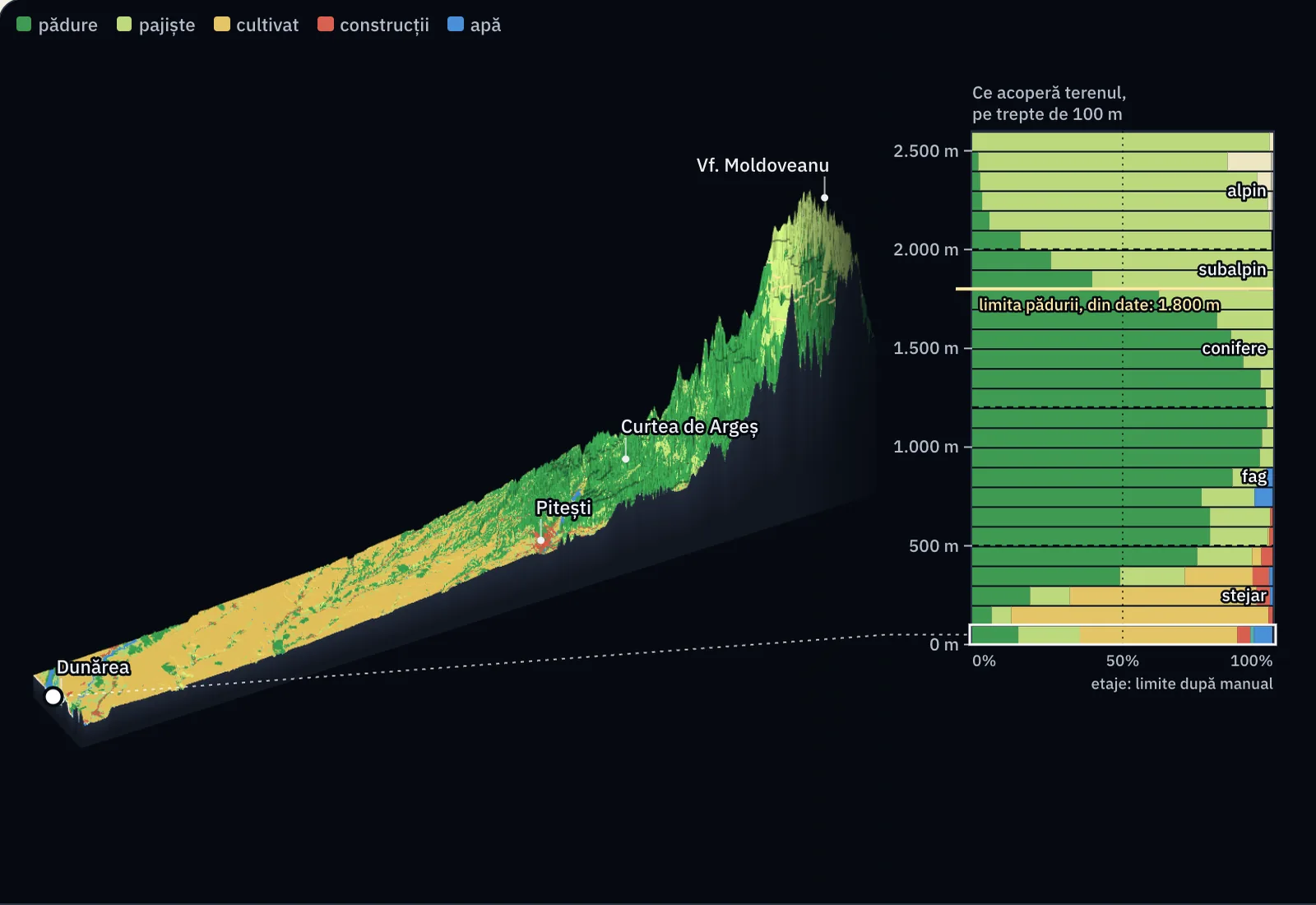
A strip of land 24 km wide starts at the Danube, near the town of Turnu Măgurele, and runs 218 km to the far side of the Făgăraș crest. Its relief is measured from satellites, and its colours show what covers each piece of land: crops, grassland, forest, houses, water.
From the Danube to Moldoveanu, you climb more than 2,500 m
You look at the strip from the south-east. At bottom left is the Danube, at 18 m altitude. At top right is Moldoveanu Peak, the highest in Romania, at 2,544 m.
The heights are greatly exaggerated relative to the distances. To scale, the mountain would hardly show: the strip is 86 times longer than the peak is high.
Up to what altitude do you think forest climbs on the Făgăraș, and why does it stop?
Below 200 m, three quarters of the land is cropland
The part of the strip below 200 m altitude covers 2,203 km², which is 42% of the whole strip. The satellite map finds cropland on 75.9% of this surface and forest on only 9.0%.
The chart on the right says the same thing in bands of 100 m. Each bar is one altitude band, and its colours show how much of the land is forest, grassland or crops. Between 100 and 200 m, the yellow of crops reaches 85.4%.
On the hills, forest passes half of the land from 350 m upward
Between 200 and 500 m, forest covers 42.7% of the land and crops 34.6%. From about 350 m upward, more than half of every step is forest.
The textbook names two belts here: the oak belt, up to 500 m, and the beech belt, between 500 and 1,200 m. In the beech belt, forest covers 84.3% of the strip.
The satellite sees the tree crowns, but its map has a single class for all trees. It does not say where oak ends and beech begins: the dotted limits on the chart are the textbook's.
Between 1,200 and 1,800 m, forest covers 86% of the land
The most wooded step of the whole strip lies between 1,100 and 1,200 m, with 98.0% forest. Above this, according to the textbook, beech gives way to conifers: spruce and fir, with needle-shaped leaves that withstand frost.
In the conifer belt, between 1,200 and 1,800 m, forest covers 86.3% and grassland 13.6%.
The mean annual temperature, calculated at 6.5 °C less for every 1,000 m of climb, falls from 12.2 °C at the Danube to 2.6 °C at 1,500 m.
In the strip, the forest stops at about 1,800 m
The yellow line joins the places at 1,800 m. At this altitude, trees cover less than half of the land: 62.1% in the 1,700–1,800 m step and 39.9% in the next. In the strip, this is the upper forest limit, calculated from the satellite map. Textbooks give 1,800 m for the Carpathians; from one slope to another, the limit rises or falls.
The main cause is cold. Here the calculated mean annual temperature is 0.6 °C: summer is too short and too cold for trees to form a forest any more.
The change is gradual. Between 1,600 and 2,100 m, forest falls from 81% to 16% of the land.
Above the forest, shrubs and grassland remain
Between 1,800 and 2,000 m, the textbook places the subalpine belt, with shrubs of mountain pine (jneapăn) and juniper. The satellite map has a “shrubland” class, but in the strip it covers under 0.1% of the land; in these steps it finds 66.5% grassland and 33.3% trees. The map cannot show where the mountain pine scrub is.
Above 2,000 m is the alpine belt: 89.7% grassland with short grasses. Bare rock and snow cover under 1% of the map; near the crest, between 2,400 and 2,500 m, the map puts 14.5% of the land in the “moss and lichen” class.
The climb resembles a journey north
Broadleaved trees, then conifers, then grassland without trees: vegetation changes in the same order from the latitude of Romania northward, up to the tundra.
On the mountain, the same change happens over a climb of 2.5 km, which, by calculation, cools the air by 16 °C. Day length and the seasons stay those of the latitude, however: on Moldoveanu there is no polar night.
Three soils on the way up
The drawing puts three soil profiles at the same scale. The letters are horizons: A, the dark layer rich in humus; E, the pale layer from which water has washed out the clay; B, the layer where clay collects; C, broken rock; R, hard rock.
The cernoziom (chernozem) of the plain has an A horizon 55 cm thick; the profile was described at Fundulea, on the Bărăgan plain, 140 km east of the strip. The luvosol (luvisol), the soil under oak and beech forests, has at Albota, near Pitești, 22 cm of humus layer and a washed layer down to 42 cm. On the crest, the soil lies directly on rock, at most 25 cm from the surface.
A centimetre of soil usually takes more than 1,000 years to form
Soil forms very slowly: usually more than 1,000 years for one centimetre. The speed depends on climate, rock and relief.
Erosion takes the top layer first, the A horizon, the one with humus: 55 cm at Fundulea, 22 cm at Albota, at most 25 cm in all on the crest. The thinner the layer, the more each lost centimetre matters.
The cultivated hills between Pitești and Curtea de Argeș belong to the Getic Piedmont, one of the regions where rain washes soil off the slopes. Across Romania, water erosion affects 6.3 million hectares of farmland.
Now you explain
Move the mountain, in your mind, next to the Equator, to a place where it is 27 °C at the foot all year. What would then cover the crest of 2,544 m? Explain why the belts climb higher on mountains near the Equator, and why a summit there, however high, has no polar night.
Compare with an answer
With the same drop of 6.5 °C per 1,000 m, the crest would have almost 11 °C, as it is in Romania today at about 250 m, in the oak belt: cold would no longer stop the forest anywhere on the mountain. The temperature at the Făgăraș forest limit, 0.6 °C, would sit only at about 4,050 m. The belts climb because the climb starts from a higher temperature. Polar night is a matter of latitude; altitude does not change the length of the day.
Lesson 7.2, biogeographic zones and mountain vegetation belts
Lesson 7.3, soil and its profile