Chapter 6 · WatersLesson 6.2
Inland waters: groundwater, rivers, lakes and glaciers
After two weeks without rain, the Mureș river keeps flowing. Where does the water come from?
Before you read: what do you think?
How much of the planet’s fresh water is in rivers?
See the answer
About 0.006%. Most fresh water is ice and permanent snow (68.7%) or groundwater (30.1%). Yet people obtain most of their water from rivers, lakes and shallow underground layers, where it is replenished quickly.
At the entrance to the Danube Delta, the Danube brings an average of 6,437 cubic metres of water every second: a million cubic metres in less than three minutes. It flows like this even in months with no rain at all. This water fell as rain or snow days, months or years ago and waited in the soil, rocks, lakes and mountain snow.
Between rains, the river receives water from the ground
After two weeks without rain, the Mureș flows with water emerging from the ground: springs and shallow groundwater feed rivers between rains. It is still rainwater, fallen earlier.
Some rainwater soaks into the ground. It descends through permeable rocks with pores and cracks (sand, gravel and fractured limestone) until it meets an impermeable rock, such as clay. Above it, water fills all the spaces and forms an aquifer. An aquifer is permeable rock saturated with water, from which water can flow to wells and springs.
The first aquifer below the surface holds shallow groundwater. Its upper surface is the water table. This groundwater feeds wells and is easily polluted; the water table rises after rain and falls during drought. Lower down, between two impermeable layers, is deep groundwater, better protected and often under pressure; from a borehole this water can rise to the surface on its own (artesian water).
A place where groundwater emerges naturally at the surface is a spring. Water that has dissolved many salts or gases along the way is mineral water; water that comes from great depths and emerges warm is thermal water.
Fresh water is scarce and most of it is out of sight
Of all fresh water, 68.7% is ice and permanent snow and 30.1% is groundwater. Freshwater lakes hold just 0.26%, and rivers 0.006%. Glaciers, groundwater, lakes and rivers are inland waters, the waters found on land. Almost all are fresh and together they account for about 3% of the planet’s water. Yet people obtain most of their water from rivers, lakes and shallow underground layers, where it is replenished quickly.
The river, from source to mouth
A river is a permanent flow of water. It begins at a source, follows its course (upper, middle and lower) and ends at its mouth, in another river, a lake or the sea. A smaller river that flows into another is a tributary; the meeting place is a confluence. Romanian distinguishes a fluviu: a large river that flows into the sea or ocean.
The entire area from which a river and its tributaries collect water is its drainage basin. The line separating two neighbouring basins follows the ridges between them and is called the watershed: rain falling on one side reaches one river, rain on the other side reaches another.
Discharge is the volume of water passing through a cross-section of a river in one second, measured in cubic metres per second (m³/s). Water level is a different measure: the height of the water relative to a reference point. The way discharge changes over the year is called the hydrological regime. On Romania’s rivers, high water usually comes in spring, when rain coincides with snowmelt; low water comes in late summer, autumn and winter.
For the curious
At its mouth, a major river can form a delta if it deposits sediment, or an estuary if tides are strong.
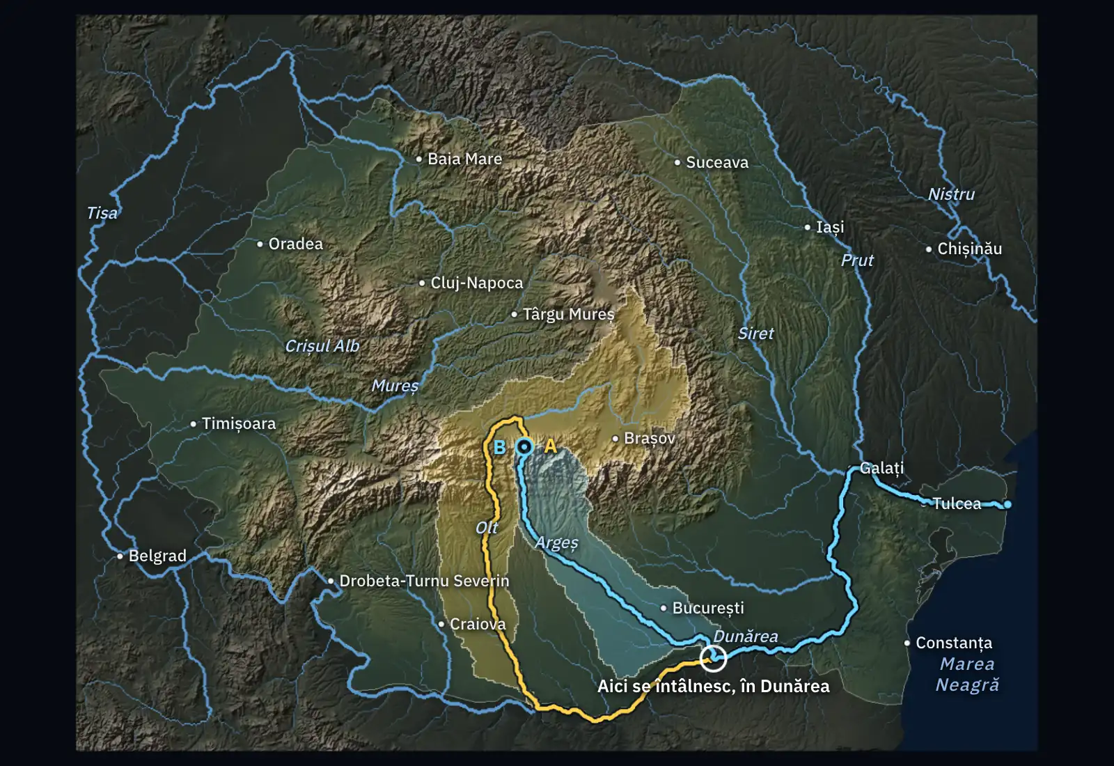
| Rain falling at | passes through | Route | Descends |
|---|---|---|---|
| Făgăraș Mountains, north of the ridge | Olt → Danube → Sulina branch → Black Sea | 910 km | 2,230 m |
| Făgăraș Mountains, south of the ridge | Argeș → Danube → Sulina branch → Black Sea | 740 km | 2,230 m |
| Cluj-Napoca | Someșul Mic → Someș → Tisa → Danube → Sulina branch → Black Sea | 2,210 km | 350 m |
| Baia Mare | Săsar → Lăpuș → Someș → Tisa → Danube → Sulina branch → Black Sea | 1,990 km | 220 m |
| Timișoara | Bega Veche → Bega → Tisa → Danube → Sulina branch → Black Sea | 1,330 km | 90 m |
| Brașov | Timiș → Ghimbășel → Bârsa → Olt → Danube → Sulina branch → Black Sea | 1,060 km | 620 m |
| Bucharest | Dâmbovița → Argeș → Danube → Sulina branch → Black Sea | 500 km | 80 m |
| Iași | Bahlui → Jijia → Prut → Danube → Sulina branch → Black Sea | 540 km | 60 m |
| Constanța | Black Sea | 5 km | 50 m |
| Chișinău | Bîc → Dniester → leaves the map | 200 km | 50 m |
Measurements and calculation. The relief is the Copernicus GLO-30 model, averaged on cells of about 500 m; the shadows are calculated with the slopes multiplied by six. The route of the drop is calculated: on a grid of about 1 km, water always moves into the lowest neighbouring cell, and the river beds from OpenStreetMap are cut into the relief. River names and bed lengths come from OpenStreetMap (© OpenStreetMap contributors); distances are rounded to 10 km and can be a few percent shorter than the published lengths (from Baziaș to the sea: 1,060 km calculated, 1,075 km published). The route shows where the water flows at the surface; it does not show how much water comes or when.
Lakes differ by the origin of their basins
A lake is water collected in a hollow in the land, called a basin. By the origin of that basin, natural lakes are tectonic (in depressions in the crust, such as Baikal and Tanganyika), volcanic (in craters), glacial (in hollows carved by glaciers), karst (in cavities in limestone), naturally dammed (behind a landslide), lagoons and limans (former bays or river mouths, respectively, closed off by sandbars). Artificial lakes are made by people; the largest are reservoirs behind dams.
Glaciers store the most fresh water
Glaciers form where more snow falls in winter than melts in summer. Layer upon layer, snow is compressed into ice, which flows downhill very slowly. Romania has no glaciers today; their traces remain in the glacial cirques and lakes of the Carpathians.
For the curious
Together, the ice sheets of Antarctica and Greenland hold over 99% of the ice on land. Mountain glaciers in the Alps or Himalayas are small beside them, but their summer melt feeds rivers at the foot of the mountains.
Worked example
A river’s discharge and a day’s water
Discharge is calculated by multiplying the cross-sectional area through which water flows by its average speed: Q = A × v. At a bridge, a river has a cross-section of 20 m² (for example, 10 m wide and 2 m deep on average) and the water flows at 0.5 m/s. Its discharge is Q = 20 × 0.5 = 10 m³/s.
How much water passes in a day? A day has 24 × 3,600 = 86,400 seconds, so 10 × 86,400 = 864,000 cubic metres pass under the bridge.
The same calculation for the Danube, using the average discharge of 6,437 m³/s at the entrance to the Delta: 6,437 × 86,400 ≈ 556 million cubic metres per day. Watch the units: m³/s measures discharge, m³ measures volume.
In Romania
Almost all water reaches the Danube
The Danube is 2,857 kilometres long, and its final 1,075 are in Romania or on its border. Its long-term average discharge rises from 5,380 m³/s at Baziaș, where it enters the country, to 6,437 m³/s at Ceatal Izmail, where the Delta begins. The longest rivers within Romania are the Mureș (761 km), Prut (742 km), Olt (615 km) and Siret (559 km). The Siret has the largest drainage basin, at 42,890 square kilometres. The Danube basin covers 97.4% of the country.
Romania has almost every type of lake: Sfânta Ana, in the crater of Ciomadul volcano (22 ha); Bâlea, a glacial lake in the Făgăraș Mountains (4.7 ha); Techirghiol, a salty coastal liman (1,161 ha); and Razim, a lagoon and the country’s largest lake (41,500 ha). Mineral waters emerge at Borsec and Covasna, and thermal waters at Băile Herculane and Băile Felix.
In brief
- Inland waters are groundwater, rivers, lakes and glaciers; of the planet’s fresh water, 68.7% is ice and 30.1% is groundwater.
- Groundwater fills the pores of permeable rock above impermeable rock; the shallow groundwater layer is the first aquifer, while deep groundwater lies between two impermeable layers.
- A river has a source, course and mouth; its drainage basin is the area from which it collects water, and a watershed separates two basins.
- Discharge is the volume of water passing through a river cross-section in one second (m³/s); the hydrological regime shows how discharge changes during the year.
- By origin, lakes are tectonic, volcanic (Sfânta Ana), glacial (Bâlea), karst, naturally dammed, lagoons (Razim), limans (Techirghiol) and artificial.
- The Danube is 2,857 kilometres long, of which 1,075 are in Romania, and has an average discharge of 6,437 m³/s at the entrance to the Delta; the longest river in the country is the Mureș, at 761 km.
Common mistakes
WrongGroundwater is a lake or river in an underground cave.
RightMost groundwater fills pores and cracks in rocks, like water in a sponge. Caves with rivers exist only in some limestone regions.
WrongRiver discharge and level are the same thing.
RightDischarge is a volume per second (m³/s); level is a height (cm). The same discharge produces a low level in a wide channel and a high level in a narrow one.
WrongRivers flow from north to south.
RightRivers flow downhill along the slope of the land, in any direction. The Olt flows south, the Prut south-east and the Mureș west.
Test yourself
Six questions. For the first five you see the explanation at once, with the paragraph of the lesson that supports it; for the ones with a written answer you compare with a good answer.
What is the first aquifer below the surface, from which wells draw water?
Answer
b) Shallow groundwater layer. The shallow groundwater layer is closest to the surface; its level therefore depends on rain and is easily polluted. Deep groundwater lies between two impermeable layers.
What is a watershed?
Answer
d) The line separating two neighbouring basins. The watershed follows ridges: on either side, rainwater flows towards different rivers. The place where one river joins another is a confluence.
What kind of lake is Sfânta Ana?
Answer
a) Volcanic lake. Sfânta Ana occupies a volcanic crater. Bâlea is a glacial lake and Techirghiol is a liman.
How many kilometres of the Danube’s course lie in Romania or on its border?
Answer
c) 1,075. 2,857 kilometres is the length of the whole river; the Mureș is 761 km in Romania, and the Olt 615 km.
A river has a flow cross-section of 30 m² and an average water speed of 2 m/s. What is its discharge in m³/s?
m³/sAnswer
60 m³/s. Q = A × v = 30 × 2 = 60 m³/s.
In a village on a plain, wells run dry in the third month of drought, but the town hall’s deep borehole yields water as before. Explain the difference.
A good answer
The wells draw from the shallow groundwater layer, the first aquifer, which is replenished directly by rain and falls quickly when rain stops. The borehole reaches deep groundwater between two impermeable layers, replenished slowly from far away, so it feels the drought much later.
A complete answer distinguishes the shallow groundwater layer from deep groundwater and links each to how it is replenished.
Terms
- aquifer
- A layer of permeable rock whose pores and cracks are full of water.
- shallow groundwater layer
- The first aquifer below the land surface, replenished directly by rain; its upper surface is the water table.
- spring
- A place where groundwater emerges at the surface; also the point where a river begins.
- drainage basin
- The area from which a river and its tributaries collect water.
- watershed
- The line, usually along ridges, that separates two neighbouring drainage basins.
- discharge
- The volume of water passing through a river cross-section in one second, measured in m³/s.
- hydrological regime
- The way a river’s discharge and level change over the year.
Sources and link to the programme
- NASA Earth Observatory – The water cycle (tabelul „Estimate of global water distribution”, după Gleick 1996) – shares of fresh water: ice 68.7%, groundwater 30.1%, freshwater lakes 0.26%, rivers 0.006%
- NSIDC – Ice sheet quick facts – how snow becomes ice; the Antarctic and Greenland ice sheets hold over 99% of ice on land
- ICPDR – Danube River Basin (pagină arhivată la IW:LEARN) – length of the Danube, 2,857 km
- ICPDR – Romania (pagină arhivată la IW:LEARN) – 97.4% of Romania lies in the Danube basin
- Administrația Națională „Apele Române” – Planul de management al riscului la inundații, ciclul II, fluviul Dunărea (date INHGA) – 1,075 km in Romania; long-term average discharges: 5,380 m³/s at Baziaș (1976–2019), 6,437 m³/s at Ceatal Izmail (1921–2019)
- INS – Anuarul statistic al României, capitolul 1 Geografie (tabelele 1.4 și 1.5; copie arhivată) – river lengths within Romania (Mureș 761, Prut 742, Olt 615, Siret 559 km), Siret basin (42,890 km²); type and area of lakes Sfânta Ana, Bâlea, Techirghiol and Razim
- Copernicus DEM GLO-30 – model digital al terenului (ESA, Copernicus Data Space) – terrain used to calculate flow directions, basin boundaries and rivers on the map
- OpenStreetMap – date © colaboratorii OpenStreetMap (ODbL) – river courses and names on the map
From the programme: “Inland waters – a vital resource for society” (common core). Programme competences covered: 1.3, 2.3, 4.5.