Four administrative systems, one place
Your village has been on four different maps
Romania had 71 counties in 1930, 10 ținuturi in 1938, 16 regions between 1960 and 1968. Today: 41 counties and Bucharest. Focșani has carried four names with not one word in common — Putna, Dunărea de Jos, Galați, Vrancea — without ever moving. Search for your own commune and see which four were its own.
Focșani stayed where it was while the lines above it moved
The town is where it has always been. In 1930 it was the seat of Putna county. Eight years later the administrative reform placed it in Ținutul Dunărea de Jos, run from Galați. Through the Soviet-style region years it sat in the Galați region. Since 1968 it has been the seat of Vrancea county. Four names, and none of them borrows a word from another.
- 1930Putnacounty
- 1938Dunărea de Josținut
- 1960–1968Galațiregion
- todayVranceacounty
Of the 40 towns that are county seats today, only 4 have four parent names with not a single word shared between them: Călărași, Focșani, Giurgiu and Sfântu Gheorghe. The forty-first county, Ilfov, is seated in Bucharest, outside its own territory, so it does not enter the count.
Reșița shows the other pattern. Caraș county in 1930, Ținutul Timiș in 1938, the Banat region from 1960 to 1968, and today the seat of Caraș-Severin — four different names, the last of which brings back the first.
- 1930Carașcounty
- 1938Timișținut
- 1960–1968Banatregion
- todayCaraș-Severincounty
Across all 3,186 communes and towns as they stand today, 733 have four different names for the four systems, and only 27 carried the same name through all four. For 1,432 of them — 44.9% — the 1930 county was not called what today's county is called.
Find your own place on the four maps
The four buttons redraw the same country under the four systems. The 1930 map is visibly larger because the country was: Bessarabia, northern Bukovina and southern Dobruja are in it, and the thin outline marks where the border runs today. Search for a name, or touch the map, and the four units that held that place appear.
What is exact here and what is not. A search by name answers from the checked data. A touch on the map is resolved on a grid of about 800 metres, which names the commune containing the point 94.1% of the time; close to a boundary it can name the neighbour. The 1960–1968 regions are an approximate reconstruction, and the lines between them do not bear close reading — see the method. For 1960–1968, the region's raioane appear under it as a list of names: they are not drawn on the map and cannot be selected, because their boundaries exist nowhere as geometry.
71 counties, 12 of them now in other countries
Greater Romania was divided into 71 counties. Recomputed from the published outline, they covered 297,487 km², against 238,393 km² today.
Twelve of them have essentially nothing inside the present border. Nine are in Bessarabia — Bălți, Cahul, Cetatea Albă, Hotin, Ismail, Lăpușna, Orhei, Soroca, Tighina — two in northern Bukovina (Cernăuți, Storojineț), and the twelfth, Caliacra, in southern Dobruja. Durostor, the other Cadrilater county, is a partial case, with 10.2% of its area in Romania today. Rădăuți, cut by the 1940 border, keeps 56.0%, and Dorohoi 87.7%.
Read the other way, today's counties are stitched together from several interwar ones. The counties drawing on the most are Bacău and Suceava, each covering ground that belonged to 8 different counties in 1930.
A discrepancy inside the source. The recomputed area is 1.2% larger than the figure published in the same file (294,030 km²). The 1930 outline was produced by warping a 1938–1941 German ethnic map onto a 1910 Austrian topographic base, and the difference comes from there. It has not been rescaled here.
10 ținuturi, 4 of them with two names
The administrative law of 14 August 1938 gathered the 71 counties into 10 ținuturi. Two of their capitals, Chișinău and Cernăuți, are now in other countries.
| Ținut | Name proposed | Capital | Counties |
|---|---|---|---|
| Bucegi | Argeș | București | 10 |
| Someș | Crișuri | Cluj | 7 |
| Dunărea de Jos | Dunării | Galați | 10 |
| Olt | Jiu | Craiova | 6 |
| Mării | — | Constanța | 4 |
| Mureș | Alba Iulia | Alba Iulia | 9 |
| Nistru | — | Chișinău | 4 |
| Prut | — | Iași | 9 |
| Suceava | — | Cernăuți | 7 |
| Timiș | — | Timișoara | 5 |
For four of them the name is still not settled. The overview article on Wikipedia lists the initially proposed name first; each ținut's own article, citing Monitorul Oficial no. 187 of 14 August 1938, says the opposite — the title is the enacted name and the other was only the proposal. The data here follows the individual articles and keeps both names. The contradiction is recorded, not resolved.
The division was not geographical everywhere. The overview article states, citing Günther H. Tontsch's 2000 study, that "following the Italian fascist model, Transylvanian counties with a predominantly Hungarian population were placed in separate ținuturi, so that the minority percentage would be reduced across each ținut's total". Trei Scaune went into Ținutul Bucegi, run from Bucharest, and Ciuc and Odorhei into Ținutul Mureș, run from Alba Iulia alongside that ținut's other 7 counties: Alba, Făgăraș, Mureș, Sibiu, Târnava Mare, Târnava Mică, Turda.
The map was redrawn four times in ten years
In September 1950, Law no. 5 abolished the 58 counties that remained, along with 424 plăși and 6,276 communes, and replaced them with 28 regions divided into 177 raioane. Two years later Decree no. 331 merged them down to 18 and created the first Romanian administrative unit founded on ethnicity, the Hungarian Autonomous Region. In January 1956, Decree no. 12 abolished the Arad and Bârlad regions, leaving 16. In December 1960, Law no. 3 moved territory and changed names, still for 16 regions. In February 1968, Law no. 2 closed the experiment and returned to counties: 39 of them, plus the municipality of Bucharest.
The map above carries only the 1960–1968 configuration, the one reconstructed as geometry. The other three appear here as they were drawn at the time, because no reference vector map exists for them, and reconstructing four systems from images would add four layers of error instead of one fact.
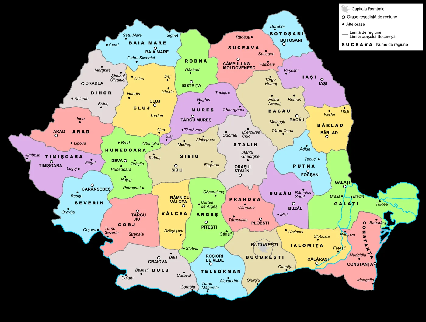

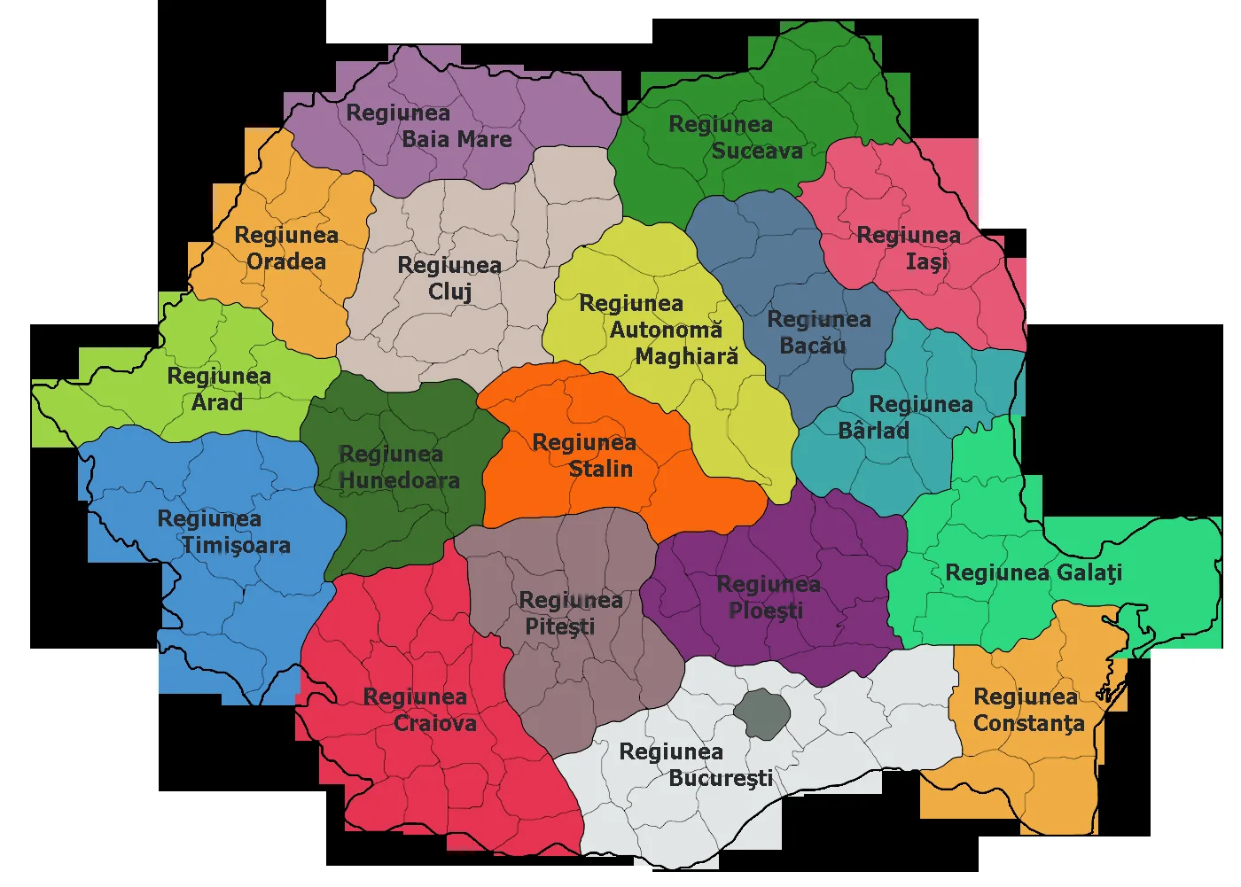

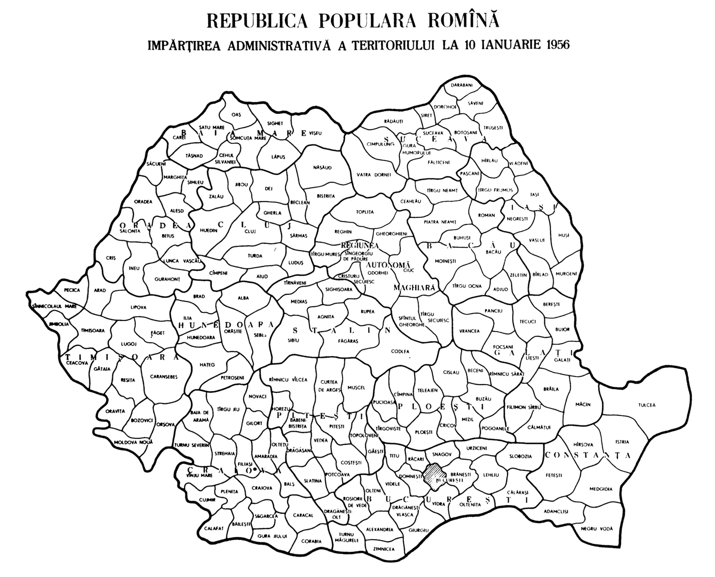

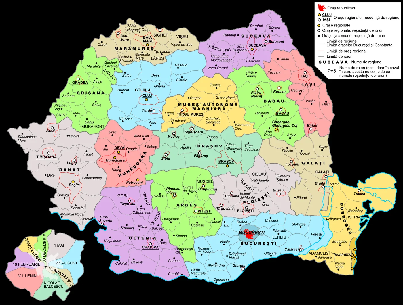

The 16 regions of 1960 were: Argeș, Bacău, Banat, Brașov, București, Cluj, Crișana, Dobrogea, Galați, Hunedoara, Iași, Maramureș, Mureș-Autonomă Maghiară, Oltenia, Ploiești, Suceava. Their names are those of historical provinces and of towns — and, once, of a minority.
A gap that stayed a gap. Regional populations at the 1966 census were not found. The source that looked likely to hold them gives only the populations of the regional capitals, not regional totals, and no official statistical publication carrying the figure could be identified. The field was left empty in the data rather than filled with an estimate.
The raioane of every region
The region was only the top level. Below it the country was divided into raioane, and the raion is the level that actually answers where a commune was: Cugir was not simply in Regiunea Hunedoara, it was in the Orăștie raion of Regiunea Hunedoara. The list below gives the raion names of every region, in all four eras.
What is exact here and what is not. This is a list of names, not a fifth map layer. The raioane are not drawn here or on the map above, because no vector map exists at raion level for any of the four eras; no name below has a boundary behind it, and none can be derived from this list. The names are transcribed from each region's article on Romanian Wikipedia, each linked to the exact revision it was read from. Where two articles disagree, both versions stay, with the disagreement written beside them. Of the 78 region–era pairs, 70 have a list read and transcribed from one cited source, with no count or cross-region overlap conflict flagged; 7 have such a conflict flagged explicitly; and for one the sources give no list at all. “No conflict flagged” is not the same as every name having been independently cross-checked against a second source — a few of the first group still carry a separate noted naming dispute in their own entry (for instance the Pitești region's 1956–1960 list).
1950–1952 28 regions, 177 raioane
Law no. 5 of 6 September 1950. The lists below add up to 182 entries, but 5 names each appear in two regions at once. Counted once, 177 remain, the total the law itself gives — provided Regiunea Vâlcea's list of five is complete, since its own article says six, and a sixth name would make 178.
Arad 5 raioane
Arad, Criș (Chișineu), Gurahonț, Ineu, Lipova
Regiunea Arad, 1950–1952
Argeș 5 raioane
Costești, Curtea de Argeș, Muscel, Pitești, Slatina
Regiunea Argeș, 1950–1952
Bacău 6 raioane
Bacău, Buhuși, Moinești, Piatra Neamț, Târgu Neamț, Târgu Ocna
Regiunea Bacău, 1950–1952
Baia Mare 7 raioane
Baia Mare, Carei, Cehu Silvaniei, Lăpuș (Târgu Lăpuș), Oaș (Negrești), Satu Mare, Sighet
Regiunea Baia Mare, 1950–1952
Bârlad 5 raioane
Bârlad, Fălciu, Huși, Vaslui, Zeletin
Regiunea Bârlad, 1950–1952
Bihor 7 raioane
Aleșd, Beiuș, Marghita, Oradea, Salonta, Săcuieni, Șimleu
The article labels this list 1950–1956, but Regiunea Bihor appears only in the 1950–1952 membership; for 1952–1960 the template gives Regiunea Oradea, which has its own lists. The list is used here for 1950–1952 alone.
Regiunea Bihor, 1950–1956
Botoșani 5 raioane
Botoșani, Darabani, Dorohoi, Săveni, Trușești
Regiunea Botoșani, 1950–1952
București 9 raioane
Brănești, București, Crevedia, Giurgiu, Mihăilești, Oltenița, Răcari, Snagov, Vidra
The Brănești, Giurgiu, Oltenița, Răcari and Vidra raioane also appear, for the same era, in the list for Regiunea Teleorman. One of the two lists is wrong; the sources do not say which, so both are left as they stand.
Regiunea București, 1950–1952
Buzău 6 raioane
Beceni, Buzău, Cislău (Pătârlagele), Mizil, Pogoanele, Râmnicu Sărat
Regiunea Buzău, 1950–1952
Cluj 8 raioane
Aiud, Câmpeni, Cluj, Dej, Gherla, Huedin, Jibou, Turda
The list sits in the article's “Organizare” section, not one headed “Raioanele”.
Regiunea Cluj, la înființare (1950)
Constanța 6 raioane
Adamclisi (Băneasa), Constanța, Hârșova, Istria (Babadag), Medgidia, Negru Vodă
Regiunea Constanța, 1950–1952
Dolj 10 raioane
Balș, Băilești, Calafat, Caracal, Corabia, Craiova, Cujmir, Gura Jiului, Plenița, Segarcea
Regiunea Dolj, 1950–1952
Galați 7 raioane
Brăila, Bujor, Călmățui (Însurăței), Filimon Sîrbu (Făurei), Galați, Măcin, Tulcea
Regiunea Galați, 1950–1952
Gorj 10 raioane
Amaradia (Melinești), Baia de Aramă, Filiași, Gilort (Târgu Cărbunești), Novaci, Oltețu (Bălcești), Strehaia, Târgu Jiu, Turnu Severin, Vânju Mare
Regiunea Gorj, 1950–1952
Hunedoara 7 raioane
Alba Iulia, Brad, Deva, Hațeg, Hunedoara, Orăștie, Petroșani
Regiunea Hunedoara, 1950–1952
Ialomița 5 raioane
Călărași, Fetești, Lehliu, Slobozia, Urziceni
Regiunea Ialomița, 1950–1952
Iași 7 raioane
Hârlău, Iași, Negrești, Pașcani, Roman, Târgu Frumos, Vlădeni
Regiunea Iași, 1950–1952
Mureș 7 raioane
Gheorgheni, Luduș, Reghin, Sângeorgiu de Pădure, Sărmaș, Târgu Mureș, Târnăveni
Regiunea Mureș, 1950–1952
Prahova 5 raioane
Câmpina, Ploiești, Pucioasa, Târgoviște, Teleajen (Vălenii de Munte)
Regiunea Prahova, 1950–1952
Putna 6 raioane
Adjud, Focșani, Năruja, Panciu, Tecuci, Măicănești
Regiunea Putna, 1950–1952
Rodna 4 raioane
Bistrița, Beclean, Năsăud, Vișeu
Regiunea Rodna, 1950–1952
Severin 5 raioane
Almăj-Mehadia, Caransebeș, Moldova Nouă, Oravița, Reșița
Regiunea Severin, 1950–1952
Sibiu 6 raioane
Agnita, Făgăraș, Mediaș, Sebeș, Sibiu, Sighișoara
Regiunea Sibiu, 1950–1952
Stalin 6 raioane
Ciuc, Odorhei, Racoș, Stalin, Sfântu Gheorghe, Târgu Secuiesc
Regiunea Stalin, 1950–1952
Suceava 7 raioane
Câmpulung, Fălticeni, Gura Humorului, Rădăuți, Siret, Suceava, Vatra Dornei
Regiunea Suceava, 1950–1956
Teleorman 13 raioane
Alexandria, Brănești, Domnești, Drăgănești-Vlașca, Giurgiu, Olteni, Oltenița, Răcari, Roșiorii de Vede, Turnu Măgurele, Videle, Vidra, Zimnicea
The Brănești, Giurgiu, Oltenița, Răcari and Vidra raioane also appear, for the same era, in the list for Regiunea București. One of the two lists is wrong; the sources do not say which, so both are left as they stand.
Regiunea Teleorman, 1950–1952
Timișoara 3 raioane
Deta, Sânnicolau Mare, Timișoara
The list sits in the article's “Istoric” section, not one headed “Raioanele”.
Regiunea Timișoara, la înființare (1950)
Vâlcea 5 raioane
Bălcești, Horezu, Lădești, Loviștea, Râmnicu Vâlcea
The article says six raioane and lists five. The missing name is nowhere in the source, so the list stays at five with the discrepancy noted.
Regiunea Vâlcea, 1950–1952
1952–1956 18 regions, 179 raioane
Decree no. 331 of 19 September 1952. The lists below add up to 181 entries, but 2 names each appear in two regions at once. Counted once, 179 remain.
Arad 6 raioane
Arad, Criș (Chișineu-Criș), Gurahonț, Ineu, Lipova, Sânnicolau Mare
Regiunea Arad, 1952–1956
Autonomă Maghiară 9 raioane
Ciuc, Gheorgheni, Odorhei, Reghin, Sângeorgiu de Pădure, Sfântu Gheorghe, Târgu Mureș, Târgu Secuiesc, Toplița
Regiunea Autonomă Maghiară, 1952–1956
Bacău 7 raioane
Bacău, Buhuși, Ceahlău, Moinești, Piatra Neamț, Târgu Neamț, Târgu Ocna
Regiunea Bacău, 1952–1956
Baia Mare 9 raioane
Baia Mare, Carei, Cehu Silvaniei, Lăpuș (Târgu Lăpuș), Oaș (Negrești), Satu Mare, Sighet, Vișeu (Vișeu de Sus), Tășnad
Regiunea Baia Mare, 1952–1960
Bârlad 9 raioane
Bârlad, Focșani, Huși, Murgeni, Panciu, Tecuci, Vaslui, Vrancea, Zeletin
The Huși and Vaslui raioane also appear, for the same era, in the list for Regiunea Iași. One of the two lists is wrong; the sources do not say which, so both are left as they stand.
Regiunea Bârlad, 1952–1956
București 19 raioane
Alexandria, Brănești, București, Călărași, Crevedia, Drăgănești-Vlașca, Giurgiu, Lehliu, Mihăilești, Oltenița, Răcari, Roșiorii de Vede, Slobozia, Snagov (Căciulați), Turnu Măgurele, Vârtoapele, Vida, Vidra, Zimnicea
Regiunea București, 1952–1960
Cluj 14 raioane
Aiud, Beclean, Bistrița, Câmpeni, Cluj, Dej, Gherla, Huedin, Jibou, Luduș, Năsăud, Sărmaș, Turda, Zalău
The article gives the state of 1956 and says the 14 raioane were formed in 1952, by adding six to the original eight. The same list is used here for 1952–1956 and for 1956–1960.
Regiunea Cluj, 1956
Constanța 7 raioane
Adamclisi (Băneasa), Constanța, Fetești, Hârșova, Istria (Babadag), Medgidia, Negru Vodă
Regiunea Constanța, 1952–1960
Craiova 20 raioane
Amaradia (Melinești), Baia de Aramă, Balș, Băilești, Calafat, Caracal, Corabia, Craiova, Cujmir, Filiași, Gilort (Târgu Cărbunești), Gura Jiului (Bechet), Novaci, Oltețu (Bălcești), Plenița, Segarcea, Strehaia, Târgu Jiu, Turnu Severin, Vânju Mare
Regiunea Craiova, 1952–1960
Galați
The sources give no list.
The Regiunea Galați article skips 1952–1956: it gives lists for 1950–1952, 1956–1960 and 1960–1968, but none for the era between them. The same article's history section says what changed in 1956 — the region gained the Focșani, Panciu, Tecuci and Vrancea raioane and lost Tulcea — but the article attributes the four gained raioane to Regiunea Putna, which does not square with the rest of this project's data: Regiunea Putna was no longer an active unit after the 1952 reorganization (it does not appear in the 1952–1956 membership above), and all four names — Focșani, Panciu, Tecuci, Vrancea — already appear in Regiunea Bârlad's own 1952–1956 list, a region abolished that same year, 1956, by Decretul nr. 12, alongside Arad. The more likely origin is Bârlad, not Putna — but that is an inference from this project's own membership data, not something any source states directly, so the pre-1956 list still cannot be reconstructed from it without inventing one.
Hunedoara 8 raioane
Alba Iulia, Brad, Deva, Hațeg, Hunedoara, Orăștie, Petroșani, Sebeș
Regiunea Hunedoara, 1952–1960
Iași 14 raioane
Botoșani, Darabani, Dorohoi, Hârlău, Huși, Iași, Negrești, Pașcani, Roman, Săveni, Târgu Frumos, Trușești, Vaslui, Vlădeni
The Huși and Vaslui raioane also appear, for the same era, in the list for Regiunea Bârlad. One of the two lists is wrong; the sources do not say which, so both are left as they stand.
Regiunea Iași, 1952–1956
Oradea 7 raioane
Aleșd, Beiuș, Marghita, Oradea, Salonta, Săcuieni, Șimleu (Șimleu Silvaniei)
Regiunea Oradea, 1952–1956
Pitești 14 raioane
Băbeni-Bistrița, Costești, Curtea de Argeș, Drăgănești-Olt, Drăgășani, Găești, Horezu, Muscel, Pitești, Potcoava, Râmnicu Vâlcea, Slatina, Topoloveni, Vedea
The source puts no period on this list, so it is used for the whole life of the region, 1952–1960, as the navigation template gives it. The Regiunea Pitești article says the rename to Argeș happened in 1956, but the Direcția Centrală de Statistică sheet for the census of 21 February 1956, printed in 1959 (the figure in this section) names the region PITEȘTI and shows the Vedea raion rather than Loviștea. The sheet is a contemporary artefact rather than a retelling, so the region's name and the presence/absence of these two raioane, as of the sheet's own reference date (21 February 1956), follow the sheet rather than the articles. This list and the one in the Regiunea Argeș article actually differ by three names, not the two above: this list also has Potcoava, which the Argeș list lacks. The sheet confirms only the region's membership at its own date — it does not independently confirm the rest of the Regiunea Argeș article's list for 1960–1968, and it says nothing about whether any raion changed between 1956 and 1968.
Regiunea Pitești, fără etichetă de perioadă
Ploiești 14 raioane
Beceni, Buzău, Câmpina, Cislău (Pătârlagele), Cricov (Urlați), Mizil, Ploiești, Pogoanele, Pucioasa, Râmnicu Sărat, Sinaia, Târgoviște, Teleajen (Vălenii de Munte), Urziceni
The list sits in the article's “Subdiviziuni” section, not one headed “Raioanele”.
Regiunea Ploiești, 1952–1956
Stalin 8 raioane
Agnita, Codlea, Făgăraș, Mediaș, Rupea, Sibiu, Sighișoara, Târnăveni
The article adds, separately from the raioane, the regionally subordinated towns Mediaș, Sibiu and Orașul Stalin. They are not counted here as raioane.
Regiunea Stalin, 1952–1960
Suceava 7 raioane
Câmpulung, Fălticeni, Gura Humorului, Rădăuți, Siret, Suceava, Vatra Dornei
Regiunea Suceava, 1950–1956
Timișoara 9 raioane
Almaș (Mehadia), Caransebeș, Deta, Făget, Lugoj, Moldova Nouă, Oravița, Reșița, Timișoara
Regiunea Timișoara, 1952–1956
1956–1960 16 regions, 190 raioane
Decree no. 12 of 10 January 1956.
Autonomă Maghiară 10 raioane
Ciuc, Cristuru Secuiesc, Gheorgheni, Odorhei, Reghin, Sângeorgiu de Pădure, Sfântu Gheorghe, Târgu Mureș, Târgu Secuiesc, Toplița
Regiunea Autonomă Maghiară, 1956–1960
Bacău 9 raioane
Adjud, Bacău, Buhuși, Moinești, Piatra Neamț, Roman, Târgu Neamț, Târgu Ocna, Zeletin (Podu Turcului)
Regiunea Bacău, 1956–1960
Baia Mare 9 raioane
Baia Mare, Carei, Cehu Silvaniei, Lăpuș (Târgu Lăpuș), Oaș (Negrești), Satu Mare, Sighet, Vișeu (Vișeu de Sus), Tășnad
Regiunea Baia Mare, 1952–1960
București 19 raioane
Alexandria, Brănești, București, Călărași, Crevedia, Drăgănești-Vlașca, Giurgiu, Lehliu, Mihăilești, Oltenița, Răcari, Roșiorii de Vede, Slobozia, Snagov (Căciulați), Turnu Măgurele, Vârtoapele, Vida, Vidra, Zimnicea
Regiunea București, 1952–1960
Cluj 14 raioane
Aiud, Beclean, Bistrița, Câmpeni, Cluj, Dej, Gherla, Huedin, Jibou, Luduș, Năsăud, Sărmaș, Turda, Zalău
The article gives the state of 1956 and says the 14 raioane were formed in 1952, by adding six to the original eight. The same list is used here for 1952–1956 and for 1956–1960.
Regiunea Cluj, 1956
Constanța 7 raioane
Adamclisi (Băneasa), Constanța, Fetești, Hârșova, Istria (Babadag), Medgidia, Negru Vodă
Regiunea Constanța, 1952–1960
Craiova 20 raioane
Amaradia (Melinești), Baia de Aramă, Balș, Băilești, Calafat, Caracal, Corabia, Craiova, Cujmir, Filiași, Gilort (Târgu Cărbunești), Gura Jiului (Bechet), Novaci, Oltețu (Bălcești), Plenița, Segarcea, Strehaia, Târgu Jiu, Turnu Severin, Vânju Mare
Regiunea Craiova, 1952–1960
Galați 12 raioane
Berești, Brăila, Bujor, Călmățui (Însurăței), Filimon Sîrbu (Făurei), Focșani, Galați, Liești, Măcin, Panciu, Tecuci, Vrancea (Vidra)
The article notes, citing Decree no. 423 of 5 November 1959, that the Măcin raion belonged to the region only until 1959.
Regiunea Galați, 1956–1960
Hunedoara 8 raioane
Alba Iulia, Brad, Deva, Hațeg, Hunedoara, Orăștie, Petroșani, Sebeș
Regiunea Hunedoara, 1952–1960
Iași 10 raioane
Bârlad, Hârlău, Huși, Iași, Murgeni, Negrești, Pașcani, Târgu Frumos, Vaslui, Vlădeni
Regiunea Iași, 1956–1960
Oradea 11 raioane
Aleșd, Beiuș, Criș (Chișineu-Criș), Gurahonț (Sebiș), Ineu, Lunca Vașcăului (Dr. Petru Groza), Marghita, Oradea, Salonta, Săcuieni, Șimleu (Șimleu Silvaniei)
Regiunea Oradea, 1956–1960
Pitești (Argeș) 14 raioane
Băbeni-Bistrița, Costești, Curtea de Argeș, Drăgănești-Olt, Drăgășani, Găești, Horezu, Muscel, Pitești, Potcoava, Râmnicu Vâlcea, Slatina, Topoloveni, Vedea
The Regiunea Pitești and Regiunea Argeș articles both say the rename to Argeș happened in 1956, which would put Argeș here. The navigation template gives Pitești until 1960, the 1956 statistical sheet names it PITEȘTI, and the overview article puts the region renamings at Law no. 3/1960. The name follows the sheet and the template; Argeș is recorded as an alternate.
The source puts no period on this list, so it is used for the whole life of the region, 1952–1960, as the navigation template gives it. The Regiunea Pitești article says the rename to Argeș happened in 1956, but the Direcția Centrală de Statistică sheet for the census of 21 February 1956, printed in 1959 (the figure in this section) names the region PITEȘTI and shows the Vedea raion rather than Loviștea. The sheet is a contemporary artefact rather than a retelling, so the region's name and the presence/absence of these two raioane, as of the sheet's own reference date (21 February 1956), follow the sheet rather than the articles. This list and the one in the Regiunea Argeș article actually differ by three names, not the two above: this list also has Potcoava, which the Argeș list lacks. The sheet confirms only the region's membership at its own date — it does not independently confirm the rest of the Regiunea Argeș article's list for 1960–1968, and it says nothing about whether any raion changed between 1956 and 1968.
Regiunea Pitești, fără etichetă de perioadă
Ploiești 12 raioane
Beceni, Buzău, Câmpina, Cislău (Pătârlagele), Cricov (Urlați), Mizil, Ploiești, Pogoanele, Pucioasa, Râmnicu Sărat, Târgoviște, Teleajen (Vălenii de Munte)
Regiunea Ploiești, 1956–1968
Stalin 8 raioane
Agnita, Codlea, Făgăraș, Mediaș, Rupea, Sibiu, Sighișoara, Târnăveni
The article adds, separately from the raioane, the regionally subordinated towns Mediaș, Sibiu and Orașul Stalin. They are not counted here as raioane.
Regiunea Stalin, 1952–1960
Suceava 12 raioane
Botoșani, Câmpulung, Darabani, Dorohoi, Fălticeni, Gura Humorului, Rădăuți, Săveni, Siret, Suceava, Trușești, Vatra Dornei
Regiunea Suceava, 1956–1960
Timișoara 15 raioane
Arad, Bozovici, Caransebeș, Ciacova, Făget, Gătaia, Jimbolia, Lipova, Moldova Nouă, Oravița, Orșova, Pecica, Reșița, Sânnicolau Mare, Timișoara
Regiunea Timișoara, 1956–1960
1960–1968 16 regions, 170 raioane
Law no. 3 of 24 December 1960. The lists below add up to 171 entries, but 1 names each appear in two regions at once. Counted once, 170 remain.
Argeș 13 raioane
Băbeni-Bistrița, Costești, Curtea de Argeș, Drăgănești-Olt, Drăgășani, Găești, Horezu, Loviștea, Muscel, Pitești, Râmnicu Vâlcea, Slatina, Topoloveni
The article labels this list 1956–1968, but the Direcția Centrală de Statistică sheet for the census of 21 February 1956, printed in 1959 (the figure in this section) names the region PITEȘTI at 1956 and carries no Loviștea raion: north of the Rîmnicu Vîlcea raion the Stalin region begins directly. That shows only the region's membership at the sheet's own date (21 February 1956) — it does not independently confirm the rest of this thirteen-raion list for 1960–1968, and it says nothing about whether any raion changed between 1956 and 1968. This list differs from the Regiunea Pitești one by three names, not one: it has Loviștea, which the other lacks, but it is missing Potcoava and Vedea, which the other has. The list is used here for 1960–1968, the era the template places Regiunea Argeș in, and 1956–1960 keeps the Regiunea Pitești list.
Regiunea Argeș, 1956–1968
Bacău 8 raioane
Adjud, Bacău, Buhuși, Moinești, Piatra Neamț, Roman, Târgu Neamț, Târgu Ocna
The only within-era change the sources state outright: the article splits 1960–1964 from 1964–1968, when the Buhuși raion drops out of the list. 1964–1968: Adjud, Bacău, Moinești, Piatra Neamț, Roman, Târgu Neamț, Târgu Ocna.
Regiunea Bacău, 1960–1964
Banat 12 raioane
Arad, Bozovici, Caransebeș, Deta, Făget, Lipova, Lugoj, Moldova Nouă, Oravița, Orșova, Sânnicolau Mare, Timișoara
The article adds the regional town of Reșița separately, as one that “had an area and a number of localities equivalent to a raion”. It is not counted here as a raion. The list sits in the article's “Subdiviziuni” section.
Regiunea Banat, 1960–1968
Brașov 8 raioane
Agnita, Făgăraș, Mediaș, Rupea, Sfântu Gheorghe, Sibiu, Sighișoara, Târgu Secuiesc
The article adds, separately from the raioane, the regionally subordinated towns Brașov, Făgăraș, Mediaș, Sibiu and Sighișoara. They are not counted here as raioane.
Regiunea Brașov, 1960–1968
București 21 raioane
Alexandria, Brănești, București, Călărași, Crevedia, Drăgănești, Fetești, Giurgiu, Lehliu, Mihăilești, Oltenița, Răcari, Roșiorii de Vede, Slobozia, Snagov, Turnu Măgurele, Urziceni, Vârtoapele, Vida, Vidra, Zimnicea
The Fetești raion also appears, for the same era, in the list for Regiunea Dobrogea. One of the two lists is wrong; the sources do not say which, so both are left as they stand.
Regiunea București, 1960–1968
Cluj 9 raioane
Aiud, Bistrița, Câmpeni, Dej, Gherla, Huedin, Năsăud, Turda, Zalău
Regiunea Cluj, 1960
Crișana 11 raioane
Aleșd, Beiuș, Criș, Gurahonț, Ineu, Lunca Vașcăului (Dr. Petru Groza), Marghita, Oradea, Salonta, Săcuieni, Șimleu
Regiunea Crișana, 1960–1968
Dobrogea 9 raioane
Adamclisi (Băneasa), Constanța, Fetești, Hârșova, Istria (Babadag), Măcin, Medgidia, Negru Vodă, Tulcea
The Fetești raion also appears, for the same era, in the list for Regiunea București. One of the two lists is wrong; the sources do not say which, so both are left as they stand.
Regiunea Dobrogea, 1960–1968
Galați 7 raioane
Brăila, Bujor, Făurei, Focșani, Galați, Panciu, Tecuci
Regiunea Galați, 1960–1968
Hunedoara 9 raioane
Alba Iulia, Brad, Deva, Hațeg, Hunedoara, Ilia, Orăștie, Petroșani, Sebeș
Regiunea Hunedoara, 1960–1968
Iași 7 raioane
Bârlad, Hârlău, Huși, Iași, Negrești, Pașcani, Vaslui
Regiunea Iași, 1960–1968
Maramureș 8 raioane
Baia Mare, Carei, Cehu Silvaniei, Lăpuș (Târgu Lăpuș), Oaș (Negrești), Satu Mare, Sighet, Vișeu (Vișeu de Sus)
Regiunea Maramureș, 1960–1968
Mureș-Autonomă Maghiară 8 raioane
Ciuc, Gheorgheni, Luduș, Odorhei, Reghin, Târgu Mureș, Târnăveni, Toplița
Regiunea Mureș-Autonomă Maghiară, 1960–1968
Oltenia 20 raioane
Amaradia (Melinești), Baia de Aramă, Balș, Băilești, Calafat, Caracal, Corabia, Craiova, Cujmir, Filiași, Gilort (Târgu Cărbunești), Gura Jiului (Bechet), Novaci, Oltețu (Bălcești), Plenița, Segarcea, Strehaia, Târgu Jiu, Turnu Severin, Vânju Mare
Regiunea Oltenia, 1960–1968
Ploiești 12 raioane
Beceni, Buzău, Câmpina, Cislău (Pătârlagele), Cricov (Urlați), Mizil, Ploiești, Pogoanele, Pucioasa, Râmnicu Sărat, Târgoviște, Teleajen (Vălenii de Munte)
Regiunea Ploiești, 1956–1968
Suceava 9 raioane
Botoșani, Câmpulung, Dorohoi, Fălticeni, Gura Humorului, Rădăuți, Săveni, Suceava, Vatra Dornei
Regiunea Suceava, 1960–1968
Names that look like a match and are not
The hardest names to read are not the ones that changed. They are the ones that stayed. A ținut and a present-day county can share a name and cover something else entirely.
Ținutul Olt was Oltenia, run from Craiova. Today's Olt county sits in the middle of that Oltenia, seated at Slatina. Of the 430 communes whose 1938 ținut was Olt, 320 — 74.4% — are not in today's Olt county at all, but in Dolj, Gorj, Mehedinți or Vâlcea.
Ținutul Mureș was run from Alba Iulia rather than Târgu Mureș and took in most of southern Transylvania: 72.5% of its communes lie outside today's Mureș county. Ținutul Timiș covered the whole Banat, and 69.6% of its communes lie outside today's Timiș.
The same holds between the regions and the interwar counties. Of the communes in the Suceava region of 1960–1968, 85.9% had never been in the Suceava county of 1930 — which follows, once you notice that Ținutul Suceava had been run from Cernăuți. The extreme case is the Bucharest region, which reached across much of what is now Ilfov and the counties around it: 98.2% of its communes lie outside today's municipality.
Not every shared name misleads. The Hunedoara region is the one checked pair where the later unit is smaller than the interwar county of the same name, and the mismatch falls to 31.4% — here the continuity is real.
The four names, for every county seat
Each row is a town that is a county seat today, with the unit it belonged to under each of the four systems.
| County seat | 1930 | 1938 | 1960–1968 | today |
|---|---|---|---|---|
| Alba Iulia | Alba | Mureș | Hunedoara | Alba |
| Alexandria | Teleorman | Bucegi | București | Teleorman |
| Arad | Arad | Timiș | Banat | Arad |
| Bacău | Bacău | Prut | Bacău | Bacău |
| Baia Mare | Satu Mare | Someș | Maramureș | Maramureș |
| Bistrița | Năsăud | Someș | Cluj | Bistrița-Năsăud |
| Botoșani | Botoșani | Prut | Suceava | Botoșani |
| Brașov | Brașov | Bucegi | Brașov | Brașov |
| Brăila | Brăila | Dunărea de Jos | Galați | Brăila |
| Buzău | Buzău | Bucegi | Ploiești | Buzău |
| Cluj-Napoca | Cluj | Someș | Cluj | Cluj |
| Constanța | Constanța | Mării | Dobrogea | Constanța |
| Craiova | Dolj | Olt | Oltenia | Dolj |
| Călărași | Ialomița | Mării | București | Călărași |
| Deva | Hunedoara | Timiș | Hunedoara | Hunedoara |
| Drobeta-Turnu Severin | Mehedinți | Olt | Oltenia | Mehedinți |
| Focșani | Putna | Dunărea de Jos | Galați | Vrancea |
| Galați | Covurlui | Dunărea de Jos | Galați | Galați |
| Giurgiu | Vlașca | Bucegi | București | Giurgiu |
| Iași | Iași | Prut | Iași | Iași |
| Miercurea Ciuc | Ciuc | Mureș | Mureș-Autonomă Maghiară | Harghita |
| Oradea | Bihor | Someș | Crișana | Bihor |
| Piatra-Neamț | Neamț | Prut | Bacău | Neamț |
| Pitești | Argeș | Bucegi | Argeș | Argeș |
| Ploiești | Prahova | Bucegi | Ploiești | Prahova |
| Reșița | Caraș | Timiș | Banat | Caraș-Severin |
| Râmnicu Vâlcea | Vâlcea | Olt | Argeș | Vâlcea |
| Satu Mare | Satu Mare | Someș | Maramureș | Satu Mare |
| Sfântu Gheorghe | Trei Scaune | Bucegi | Brașov | Covasna |
| Sibiu | Sibiu | Mureș | Brașov | Sibiu |
| Slatina | Olt | Olt | Argeș | Olt |
| Slobozia | Ialomița | Mării | București | Ialomița |
| Suceava | Suceava | Suceava | Suceava | Suceava |
| Timișoara | Timiș-Torontal | Timiș | Banat | Timiș |
| Tulcea | Tulcea | Dunărea de Jos | Dobrogea | Tulcea |
| Târgoviște | Dâmbovița | Bucegi | Ploiești | Dâmbovița |
| Târgu Jiu | Gorj | Olt | Oltenia | Gorj |
| Târgu Mureș | Mureș | Mureș | Mureș-Autonomă Maghiară | Mureș |
| Vaslui | Vaslui | Prut | Iași | Vaslui |
| Zalău | Sălaj | Someș | Crișana | Sălaj |
How the four layers were built
Today's counties come from the layer of basic administrative units published by geo-spatial.org and ANCPI — 3,186 communes and towns, each carrying its SIRUTA code — merged by county code. The total area that produces, 238,393 km², is within 0.001% of the country's official figure.
The counties of 1930 come from the outline published by geo-spatial.org, surveyed by Andrei Nacu. The ten ținuturi of 1938 have no outline of their own: they are the union of the 1930 counties, following each ținut's own list of member counties. That list comes from the Wikipedia article for each ținut, each citing Monitorul Oficial no. 187 of 1938; the text of the law itself could not be obtained directly, so the list remains a reading of a secondary source. All 71 counties fit into the 10 ținuturi exactly, with none missing and none counted twice.
The 1960–1968 regions are the one approximate layer, and they stay labelled that way in the data. No vector map of them exists. The outline was traced from a public-domain drawing, placed on real coordinates by a transformation computed from four extreme points of the country, with residuals of 2.8 to 4.2 km at those points, then clipped to the present border. The reconstruction left gaps of about 2% of the country's area, mostly north of Satu Mare and along the coast, so the version drawn on the map is the one where every present-day commune was assigned to the region its centre falls in. That makes it continuous, not more accurate: the lines between regions follow present-day commune boundaries, not the raion boundaries of the 1960s, which nobody has measured as vectors.
This is why 256 communes — 8.0% of the total — are marked as cut by a reconstructed border: their area divides between two regions, and the label they carry is the region their centre falls in. On selection, the map shows the calculated percentage for each of the two regions, not an exact historical border.
To be small enough to send to a browser, the outlines were simplified once, on the finest layer, and the larger units were rebuilt from it. The check after simplification requires all 139 units to survive whole, and each one's area to stay within 2% of the checked outline.
Sources
- geo-spatial.org and ANCPI, the layer of basic administrative-territorial units (version 26 March 2025, SIRUTA code on every unit), licensed CC BY-SA 4.0, for today's counties.
- geo-spatial.org, "Limite județe 1930 GCS WGS84", by Andrei Nacu, licensed CC BY-SA 3.0, for the 71 interwar counties and their 1930 populations.
- Romanian Wikipedia, the article on the interwar counties and the articles on the 10 ținuturi, each citing Monitorul Oficial, part I, no. 187 of 14 August 1938.
- Romanian Wikipedia, "Organizarea teritorială a Republicii Populare Române", for the chronology of the laws of 1950, 1952, 1956, 1960 and 1968.
- Wikimedia Commons, the four administrative maps reproduced above, all in the public domain: Andrein (1950–1952 and 1960–1968), Radufan (1952–1956), Direcția Centrală de Statistică (1956).