Trafalgar Square, London
A hippo under Trafalgar Square
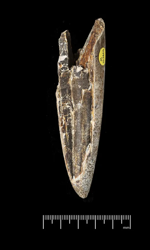
Its tusk is in the Natural History Museum, marked “TRAF. SQ. I.” and “1957”. Take the spade and dig 117 m of real ground under the fountains, from the pavement to the chalk.

Details and credit
Catalogued as from the foundations of Uganda House, Trafalgar Square; the ink reads “TRAF. SQ. I.” and “1957”. Ruler in centimetres. © The Trustees of the Natural History Museum, London, CC BY 4.0.Drag to dig · ↑ ↓ keys also work
Dig the fountain well
Drag the spade down the ground, or tap a layer; the view pulls back as you go deeper. This is the real log of the well in front of the National Gallery, sunk in the 1840s.
0,0
m down0 ftFirst 17 m. The dashed line is sea level, 12.6 m below this pavement. The right-hand column is the south side of the square, from English Heritage's survey, lined up with the well by sea level only. Hatching means nothing is known.
Layers
The log as a table
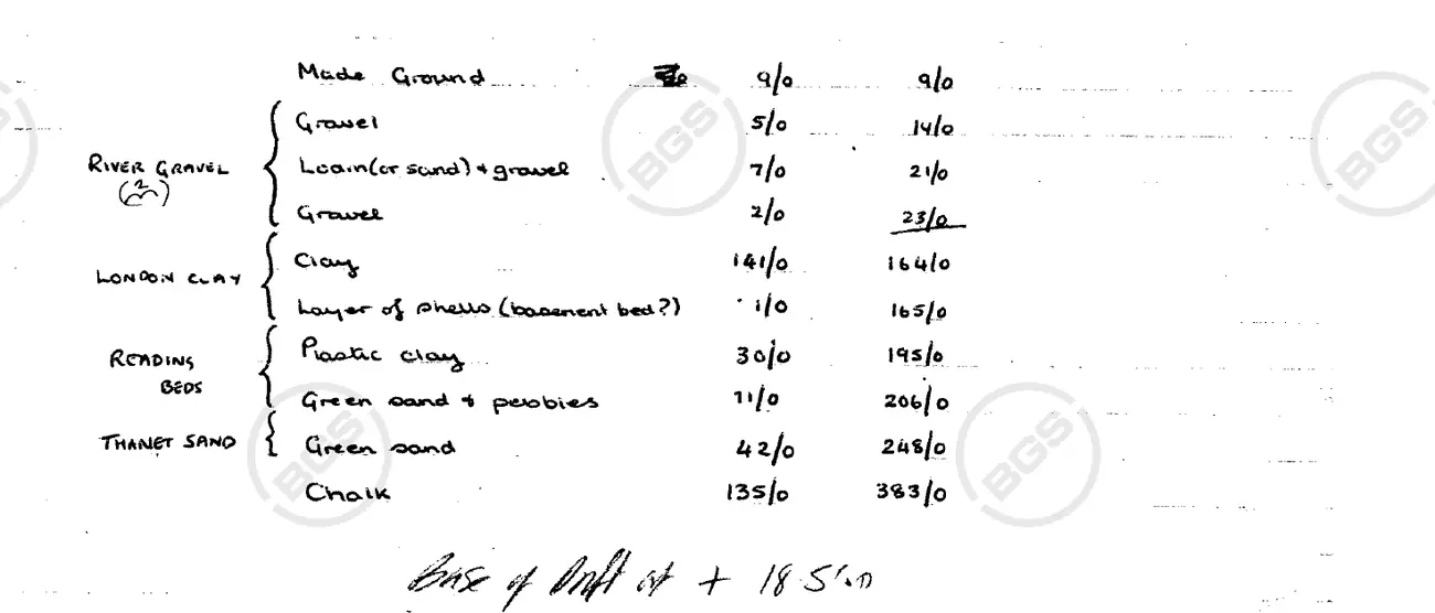
| Layer in the log | Thickness (ft) | Thickness (m) | Depth to base (ft) |
|---|---|---|---|
| Made ground · put there by people | |||
| Made ground | 9 | 2.7 | 9 |
| River gravel · Ice Age; the log gives no date (under 2.6 million years) | |||
| Gravel | 5 | 1.5 | 14 |
| Loam or sand with gravel | 7 | 2.1 | 21 |
| Gravel | 2 | 0.6 | 23 |
| London Clay · about 56 to 48 million years ago | |||
| Clay | 141 | 43.0 | 164 |
| Shells | 1 | 0.3 | 165 |
| Reading Beds and Thanet Sand · Thanet Sand about 59 to 56 million years ago; the Reading Beds run a little later | |||
| Plastic clay | 30 | 9.1 | 195 |
| Green sand and pebbles | 11 | 3.4 | 206 |
| Thanet Sand | 42 | 12.8 | 248 |
| Chalk · 100 to 66 million years ago (Late Cretaceous; the log does not narrow it) | |||
| Chalk | 135 | 41.1 | 383 |
Made ground (put there by people). Fill, rubble and paving. The log records 9 ft (2.7 m) of it beside the National Gallery.
River gravel (Ice Age; the log gives no date (under 2.6 million years)). River gravel, though the log queries the label: gravel of the Thames, laid down when it ran across this ground. The log splits it into gravel, loam or sand with gravel, and gravel again: 14 ft (4.3 m) in all.
London Clay (about 56 to 48 million years ago). Blue-grey clay from the floor of a warm sea, 142 ft (43 m) thick here. At the very bottom the log notes a thin layer of shells, marked with a question mark as the base of the series.
Reading Beds and Thanet Sand (Thanet Sand about 59 to 56 million years ago; the Reading Beds run a little later). Clay, then green sand with pebbles (the Reading Beds, 41 ft), then 42 ft of fine green Thanet Sand. All of it is older than the London Clay above.
Chalk (100 to 66 million years ago (Late Cretaceous; the log does not narrow it)). White chalk, the layer the fountain well drew its water from. The log records 135 ft of it (the typed copy says 135 or 148). The engineers stopped at 383 ft; the chalk goes on below.
Sea level (Ordnance Datum, the level Ordnance Survey measures heights from) is here: the pavement is 41 ft (12.6 m) above it. On the south side of the square the deposits with the hippo bones run from 7.4 m above sea level to between 0.5 and 3.3 m below it, resting on London Clay (English Heritage 2008). The log of this well, on the north side, records no such deposits: at these levels it shows gravel, then clay.
The clay starts here, 23 ft down and 5.6 m above sea level. On the south side the hippo deposits rest on the clay at 0.5 to 3.3 m below sea level (English Heritage 2008), so the surface of the clay drops by about 6 to 9 m between the two sides.
Top of the chalk: 248 ft (75.6 m).
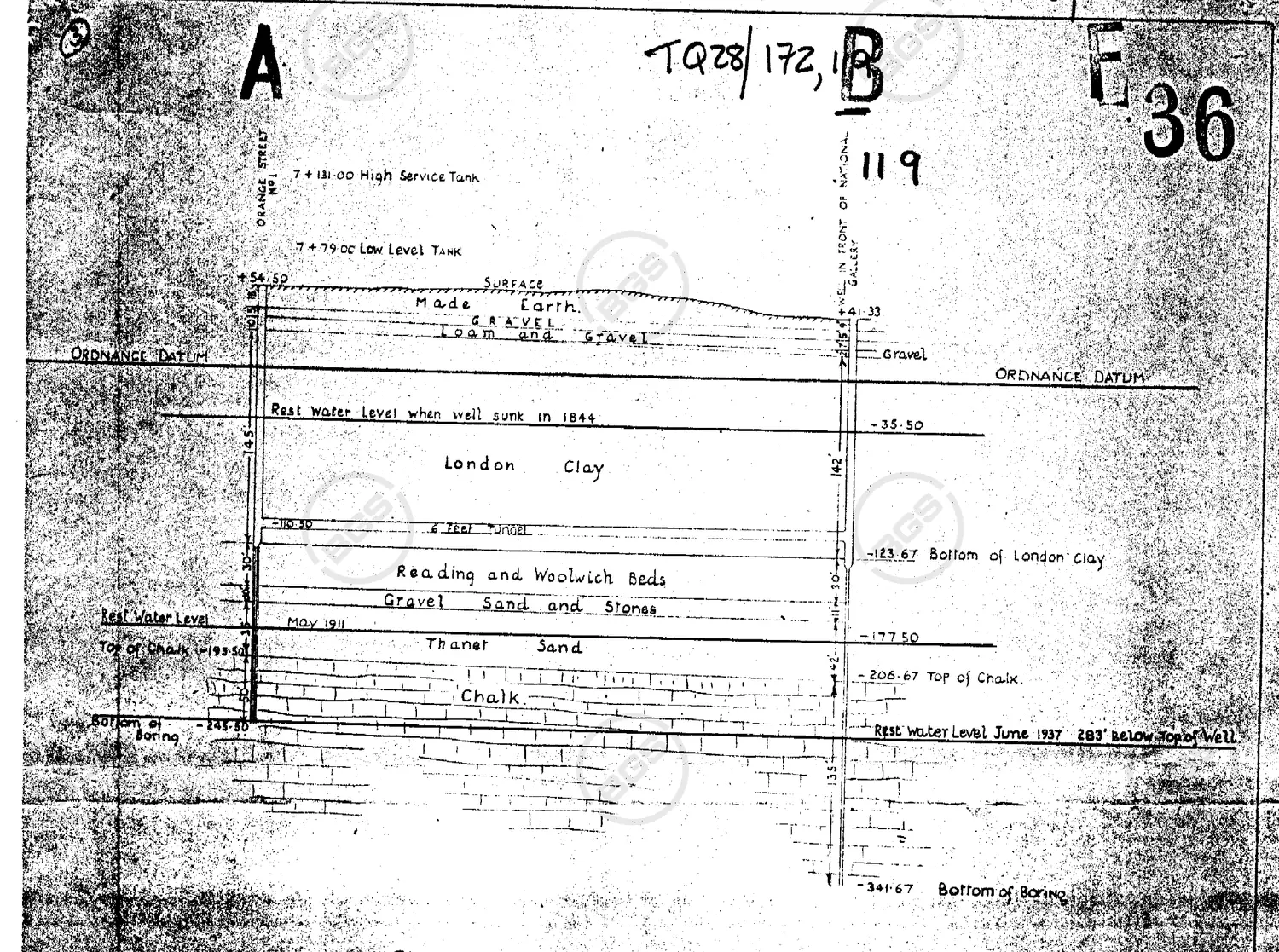
The water in the well in 1844, by the Ministry of Works drawing: 77 ft (23 m) down, inside the London Clay, pushed up the shaft from the chalk 52 m below.
June 1937: the water stood here, 283 ft (86 m) down and 35 ft (11 m) below the top of the chalk. It had fallen 206 ft (63 m) in 93 years, by the Ministry of Works drawing.
At this level, about 110 m away on the south side of the square, lie the deposits the hippo bones came from: up to 12 m of gravel, sand, silt and mud from about 125,000 years ago. The log of this well shows only gravel and clay here.
What the builders found
From 1957, foundation work under Uganda House and New Zealand House cut through deposits from the last warm period between Ice Ages: up to 12 m of gravel, sand, silt and mud, according to English Heritage. The Natural History Museum kept what came out. Its catalogue lists these fossils from two building sites at and beside the square:
| Building site | Hippopotamus | Straight-tusked elephant | Lion | Deer | Wild cattle | Other or undetermined | Total |
|---|---|---|---|---|---|---|---|
| Uganda House (foundations; tusk inked 1957) | 4 | – | 1 | 6 | 21 | 12 | 44 |
| New Zealand House, Haymarket (excavations, 1959–60) | 3 | 2 | – | 6 | 7 | 4 | 22 |
The lion is one toe bone, catalogued as Panthera leo; Franks (1960) names the species as the cave lion. “Deer” are red, fallow and giant deer. “Wild cattle” are catalogued as Bovini or Bovidae; Franks lists the aurochs.
Franks, who published the deposits in 1960, also lists a rhinoceros and a coprolite that suggests hyaenas. A hippopotamus in a Thames deposit belongs to a warm period: the Last Interglacial, which the Museum puts at about 125,000 years ago.
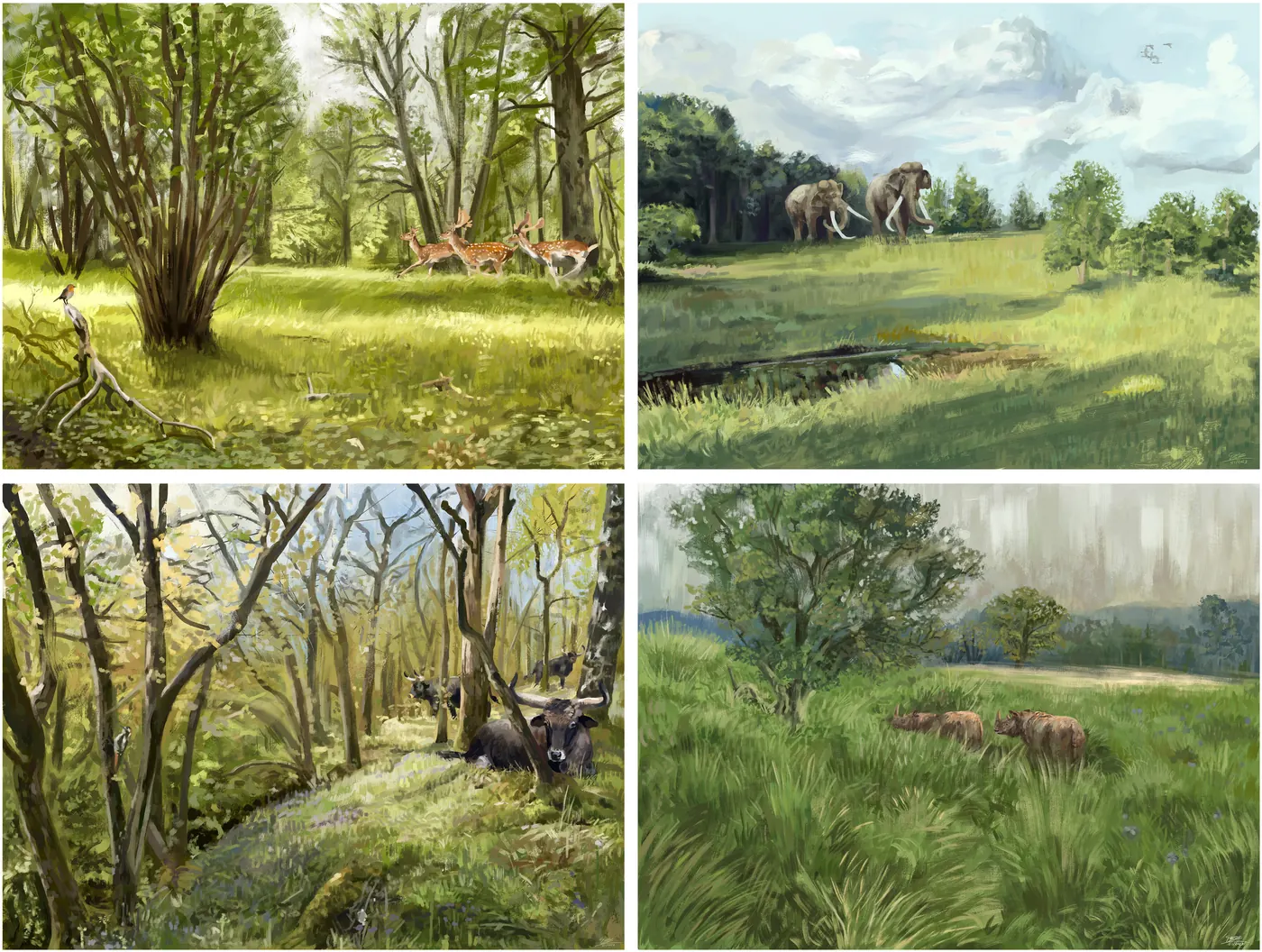
The rock that is not there
Stack the same layers by age instead of by depth. The order stays; years, not metres, set the heights. Press the button or drag the slider.
Showing
Metres
at least 45 million years
of rock missing between the London Clay and the Ice Age gravel above it.
The London Clay is 48 to 56 million years old. The next rock in the ground here is Ice Age gravel: under 2.6 million years old in this well and, on the south side, an older gravel and then the hippo deposits of about 125,000 years ago. No rock from the time in between is there: at least 45 million years are missing between the clay and the gravel above it, and the hippo deposits come almost 48 million years after the youngest age the clay can have.
The boreholes alone cannot say how much of that rock was never laid down and how much was worn away. The log shows no sandy top to the London Clay (its Claygate Member), and the British Geological Survey describes the top of the chalk as eroded, so at least part of both gaps is likely erosion.
A smaller gap lies below. The Thanet Sand is no older than about 59.2 million years and the chalk under it is at least 66 million years old, so at least 6.7 million years are missing there too. The log says only “chalk”, so its age stays anywhere in the 100 to 66 million years of the Late Cretaceous.
So far as anyone has found, no people were there to see the hippos. The Natural History Museum's Ancient Human Occupation of Britain project finds “little evidence” of people in Britain between 180,000 and 60,000 years ago.
The fountain well and its falling water
The fountains were completed in 1845. The Survey of London, quoting The Builder, says their water came from two wells, one in front of the National Gallery and one behind it, joined by a tunnel and pumped from an engine house. The log you have just dug is the one in front of the Gallery.
A Ministry of Works drawing of the wells marks the rest water level “when well sunk in 1844” as 35.5 ft below sea level: 77 ft below the street. Its last reading, June 1937, is 283 ft below the top of the well. That is 206 ft (63 m) lower in 93 years, and 35 ft (11 m) below the top of the chalk the water came from.
The effect showed in Westminster. The Medical Officer of Health, who counts three wells, wrote in his report for 1926: “By 1913, two of the wells were dry because of the fall of the water level.” The third was kept for the fountains alone, and the Metropolitan Water Board was asked for an extra supply.
Other records of the early level differ: the handwritten sheet above reads about 58.5 ft below sea level, a British Geological Survey summary gives 71 ft (Baker, 1845), the Illustrated London News said about 100 ft down in 1847, and the Medical Officer dates the wells to 1847. This page takes both ends from the Ministry's drawing so that the comparison rests on one document. With the other early readings the fall would be about 170 to 185 ft instead of 206 ft.
Go and see
Five places within a few minutes' walk of each other: four things you can look at today, and the site of one that is gone. The numbers match the plan.
Positions from OpenStreetMap, Historic England and the Natural History Museum. The well is placed from the BGS grid reference of its log.
1. Where the hippo came from
Uganda House, 58–59 Trafalgar Square · Open on the map
The Museum records the tusk's locality as the foundations of this office building on the south side of the square, about 110 m from the fountain well on the north; the tusk itself is marked 1957. The listed offices, by Sir Reginald Blomfield, date from 1914–15. Under this side of the square the interglacial deposits run from about 7 m above sea level to between 0.5 and 3.3 m below it, resting on London Clay. English Heritage reports foundation work under Uganda House in 1957–58.
2. A tape measure for the Empire
Foot of the north terrace wall · Open on the map
A plate in the wall shows ONE FOOT, TWO FEET and IMPERIAL YARD, made by Troughton and Simms and set here in 1876 by the Board of Trade's Standards Department. Bring a tape measure and check your own.
3. Where London is measured from
The paving north of the statue of Charles I · Open on the map
A plaque reads: “Mileages from London are measured from the site of the original cross.” The cross was Queen Eleanor's Cross; the statue of Charles I, cast in 1633, was set up on its site in 1674–75.
4. The lamp that was a police post
Lamp standard on the east side of the square · Open on the map
Historic England's list entry says the pedestal of this lamp served as a police post. It is often called the smallest police station in Britain. A National Archives file (WORK 20/180, 1926–36) covers the “construction of police telephone box” in the square.
5. The king's falcons
The site of the Great Mews: most of the square · Open on the map
Accounts for Westminster Palace mention building the Mews at Charing Cross from 1273 onwards; the Survey of London says the Great Mews of 1796 occupied the greater part of the site of Trafalgar Square. A mew is a cage where a hawk sheds its feathers, and the stables built on the site kept the name: that is why a row of stables is called a mews. In 1389 Geoffrey Chaucer became clerk of the king's works, and the falcon mews by Charing Cross was among the properties in his charge. William Kent's royal stables on the site were demolished in 1830.
Sources, and what is inference
Records
- BGS record TQ38SW467 (ID 1063850), the log of the well in front of the National Gallery, from Prestwich (Quarterly Journal of the Geological Society 10, p. 148, 1854) and Amos (Proceedings of the Institution of Civil Engineers 19, p. 23).
- BGS record TQ28SE1442 (ID 593023), Ministry of Works “Record of rest levels”, drawing C6121, including the 1844 and June 1937 levels.
- Franks, J. W. (1960), “Interglacial deposits at Trafalgar Square, London”, New Phytologist 59, 145–152.
- Natural History Museum Data Portal: specimens PV M 26795, 26794, 103404 and the catalogue entries tallied above (data CC0, images CC BY 4.0).
- Bridgland, D. R. (1994), Quaternary of the Thames, Geological Conservation Review vol. 7: Trafalgar Square sediments around Ordnance Datum, lying above older gravel and the London Clay.
- BGS Lexicon of Named Rock Units (London Clay Formation, Lambeth Group, Thanet Formation, Chalk Group) with the ICS International Chronostratigraphic Chart, 2024/12.
- Shackleton and others (2003), the start of the Eemian at 126,000 years ago.
- Ancient Human Occupation of Britain project, key questions.
- Westminster Medical Officer of Health, report for 1926, on the wells that supplied the Trafalgar Square fountains.
- Survey of London vol. 20 (1940): the Royal Mews, and Nelson's Column, lions and fountains.
- The London Gazette, 4 July 1876, issue 24342, p. 3778: the Order in Council on the public standards of length (a 100 ft measure and a 66 ft chain). The date on the foot-and-yard plate is the plate's own.
- Life-Records of Chaucer (Chaucer Society): the patent of 12 July 1389.
- Historic England list entries 1066235 (fountains and lamp standards) and 1266213 (Uganda House).
- London Remembers: the mileage plaque.
- Penkman, Collins, Keen and Preece (2008), British Aggregates: an improved chronology using amino acid racemization, English Heritage Research Department Report 6-2008, p. 37: the Trafalgar Square deposits, their levels and the 1957–58 foundation work.
- Pearce and others (2023), Science Advances: the reconstructions by Brennan Stokkermans.
What is our inference
- Sea level on the figure is the Ordnance Datum line of the Ministry's drawing: the pavement is 41.33 ft above it. The drawing dates the sinking of the well to 1844, the Medical Officer to 1847.
- The south-side column is drawn from English Heritage (2008) and Franks (1960) and aligned with the well only on sea level. English Heritage gives the surface of the deposits at 7.4 m OD and their base on London Clay at between 0.5 and 3.3 m below OD; the figure draws the surface and shows the base as a band. It does not draw the pavement of the south side or the layers above the deposits, which the sources do not give. Franks describes the organic beds, 0.6 to 1.5 m thick and mostly below sea level, inside this sequence.
- The statement that the clay surface drops by about 6 to 9 m subtracts English Heritage's base of the south-side deposits (0.5 to 3.3 m below sea level) from the well's top of clay (5.6 m above sea level).
- Ages are BGS stage names converted with the ICS 2024 chart. The Reading Beds and the Thanet Sand are drawn as one bar at the Thanetian bounds (59.2 to 56.0 million years), although the BGS lets the Lambeth Group, which holds the Reading Beds, run into the early Ypresian. The river gravel is drawn as under 2.6 million years because the log does not date it.
- The gaps are differences between those ages. The logs alone cannot say how much of the missing rock was never laid down and how much was removed.
- The 125,000 years is the Natural History Museum's figure. It is a correlation with the last interglacial (substage 5e) from the animals, pollen and snails, supported by amino-acid tests on snail opercula from the New Zealand House foundations (English Heritage 2008). The Ipswichian site at Bacon Hole is dated by uranium series to 124 thousand years, give or take 5.4 thousand. The age was not measured at Trafalgar Square.
Credits
Specimen photographs © The Trustees of the Natural History Museum, London, CC BY 4.0. Reconstruction paintings by Brennan Stokkermans, CC BY 4.0. Well records: Contains British Geological Survey materials © UKRI 2026, Open Government Licence. Fonts: Newsreader and Atkinson Hyperlegible, SIL Open Font Licence.