Paris, France · Île de la Cité
Île de la Cité before Haussmann: the lost streets around Notre-Dame
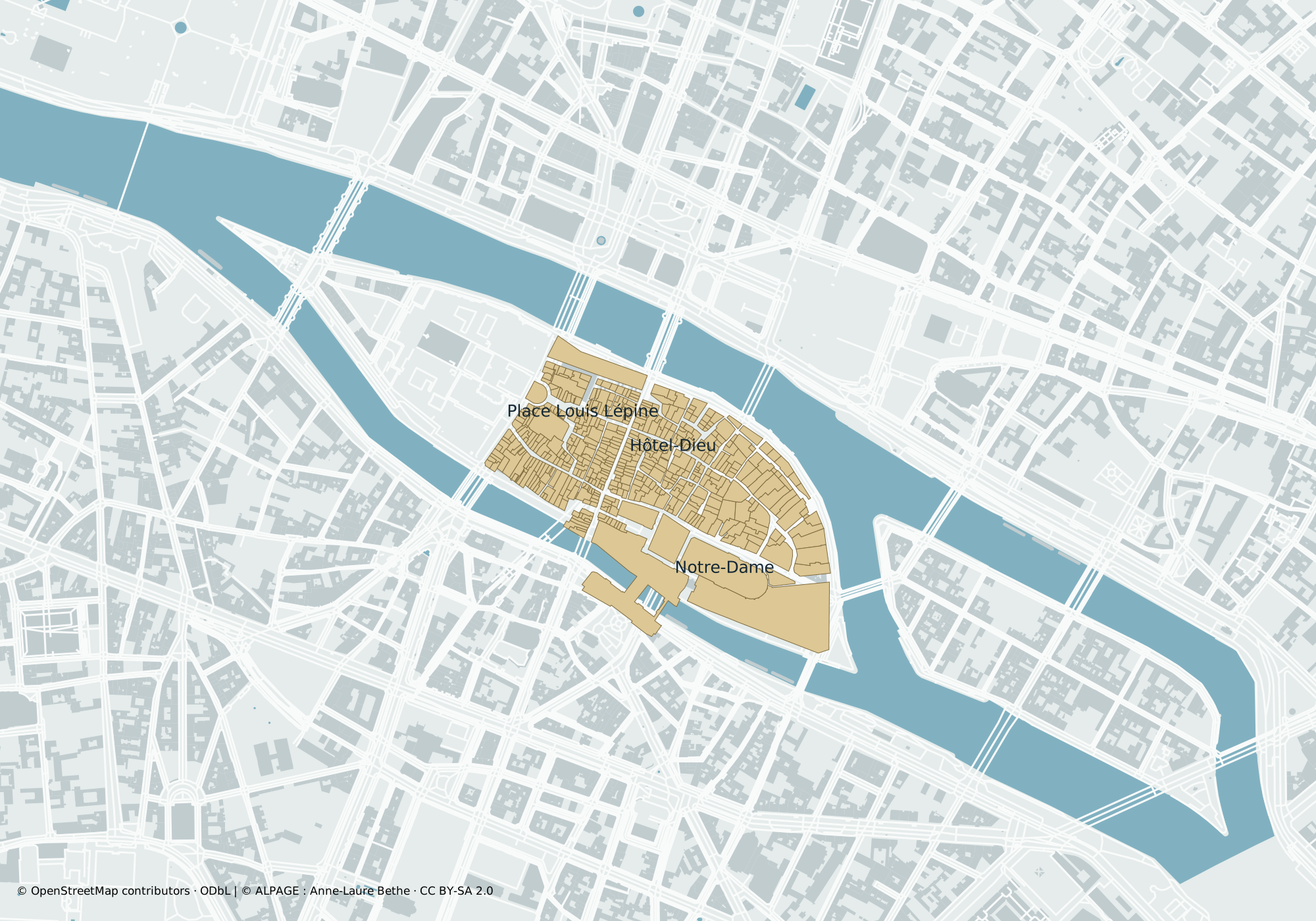
Follow a lost street through its parcels, open the photograph, then return to the area where Marville looked from.
“Before Haussmann” names the 1827 cadastre. The photographs are later: 1865–1868 and after 1865.
In 1827, the cadastre shows small plots around Notre-Dame. A street becomes easier to understand through its neighbours: a corner, a row of plots, a junction. These outlines are cadastral parcels; they do not describe the height of houses.
ALPAGE dates the Cité parcels to 1827. The surrounding map is present OSM context. The cadastre and photographs have different dates; their overlay does not prove every parcel still existed when the street was photographed. ALPAGE
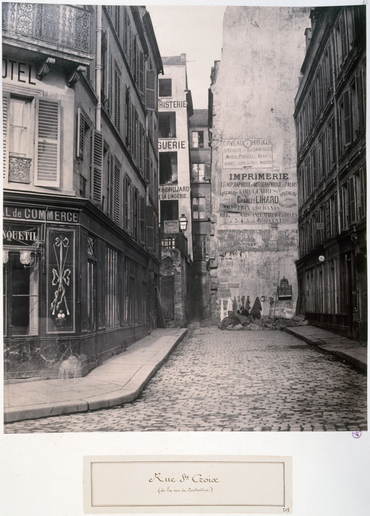
Rue Sainte-Croix has disappeared
PH898 · 1865–1868
Marville looks from rue de Constantine, now rue de Lutèce, towards rue Gervais-Laurent. Carnavalet places the lost street in the area of present place Louis Lépine, home to the flower market.
Cadastral references adjoining the route
ALPAGE_Bethe_Vass1Voies_66, ALPAGE_Bethe_Vass1Ilots_387, ALPAGE_Bethe_Vass1Ilots_388, ALPAGE_Bethe_Vass1Ilots_389, ALPAGE_Bethe_Vass1Ilots_390, ALPAGE_Bethe_Vass1Ilots_391, ALPAGE_Bethe_Vass1Parc_7674, ALPAGE_Bethe_Vass1Parc_7675, ALPAGE_Bethe_Vass1Parc_7676, ALPAGE_Bethe_Vass1Parc_7677, ALPAGE_Bethe_Vass1Parc_7711, ALPAGE_Bethe_Vass1Parc_7556, ALPAGE_Bethe_Vass1Parc_7547, ALPAGE_Bethe_Vass1Parc_7555, ALPAGE_Bethe_Vass1Parc_7499, ALPAGE_Bethe_Vass1Parc_7554, ALPAGE_Bethe_Vass1Parc_7501, ALPAGE_Bethe_Vass1Parc_7565, ALPAGE_Bethe_Vass1Parc_7553, ALPAGE_Bethe_Vass1Parc_7564, ALPAGE_Bethe_Vass1Parc_7563, ALPAGE_Bethe_Vass1Parc_7540, ALPAGE_Bethe_Vass1Parc_7541, ALPAGE_Bethe_Vass1Parc_7543, ALPAGE_Bethe_Vass1Parc_7544
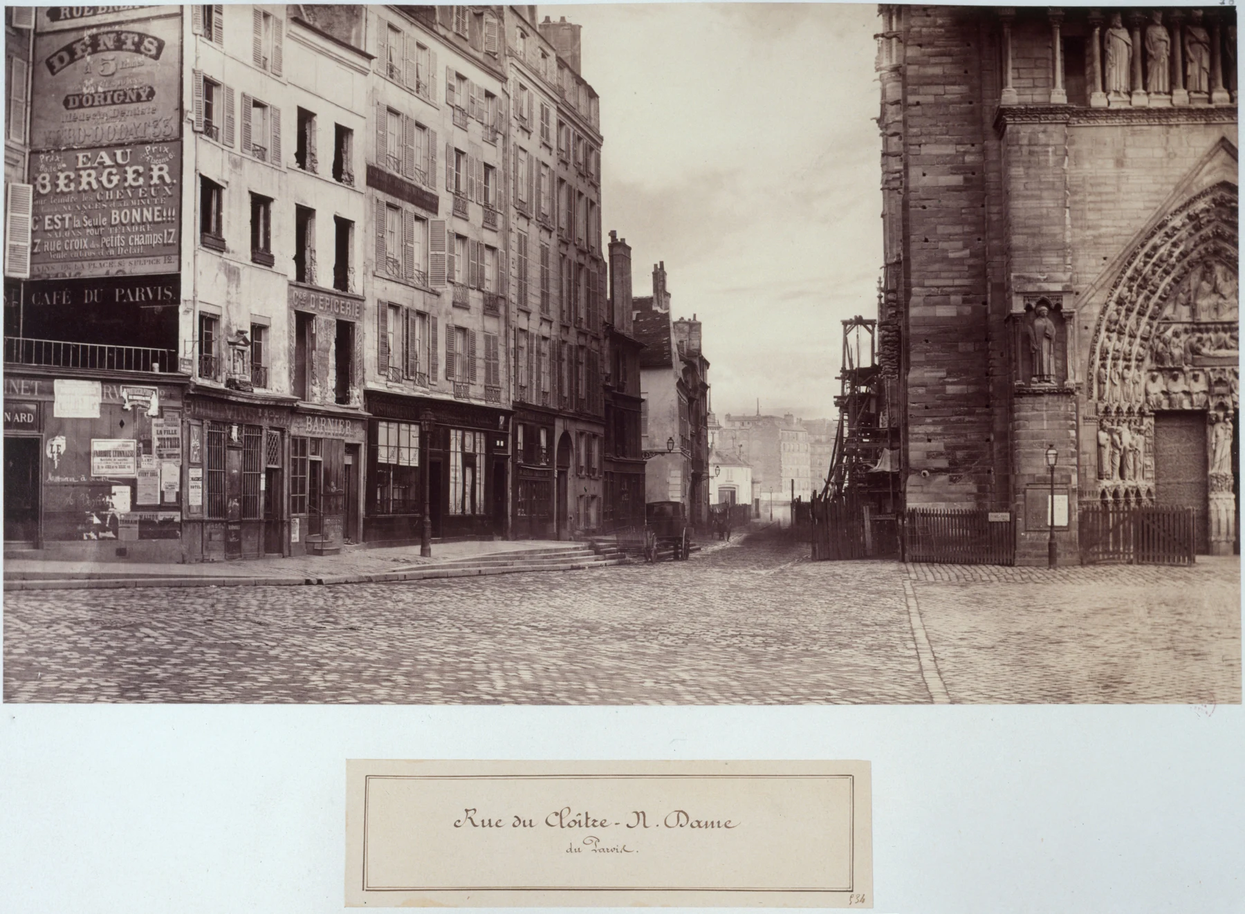
A portal keeps the landmark
PH923 · after 1865
The photograph looks east from the parvis along rue du Cloître-Notre-Dame. The Virgin portal on the cathedral’s west facade appears on the right. This surviving landmark helps orient the image on the map.
Cadastral references adjoining the route
ALPAGE_Bethe_Vass1Voies_3760, ALPAGE_Bethe_Vass1Voies_78, ALPAGE_Bethe_Vass1Voies_3761, ALPAGE_Bethe_Vass1Ilots_377, ALPAGE_Bethe_Vass1Ilots_400, ALPAGE_Bethe_Vass1Ilots_403, ALPAGE_Bethe_Vass1Ilots_1223, ALPAGE_Bethe_Vass1Parc_7807, ALPAGE_Bethe_Vass1Parc_7806, ALPAGE_Bethe_Vass1Parc_7895, ALPAGE_Bethe_Vass1Parc_7885, ALPAGE_Bethe_Vass1Parc_7884, ALPAGE_Bethe_Vass1Parc_26451, ALPAGE_Bethe_Vass1Parc_7886, ALPAGE_Bethe_Vass1Parc_7887, ALPAGE_Bethe_Vass1Parc_7888, ALPAGE_Bethe_Vass1Parc_7904, ALPAGE_Bethe_Vass1Parc_7903, ALPAGE_Bethe_Vass1Parc_7901, ALPAGE_Bethe_Vass1Parc_7902, ALPAGE_Bethe_Vass1Parc_7949
PH923 also includes parcel 26451 / block 1223, with no sheet reference.
The direction is recorded; the position is approximate
The pink area shows the proposed vicinity of the selected photograph’s viewpoint. PH898 looks towards Gervais-Laurent; PH923 looks east, with the portal on the right. The area is an interpretation using the museum description, cadastral streets and the image.
The circle is not a measured error margin. The coloured line follows the cadastral street rather than a registered photographic sight ray. Highlighted parcels adjoin the route; individual facade identifications remain uncertain. This is a virtual walk.
The new hospital starts operating in 1877
According to the AP-HP archives, the new Hôtel-Dieu was built in 1867–1878 and began receiving patients in 1877. The old hospital was demolished in 1878; its left-bank annex remained until 1909. The transformation unfolded in stages. AP-HP
The blue outlines are present OSM buildings and street axes, used for orientation. They do not reconstruct the geometry of 1877–1878. Without dated local plans, the 1860 and 1870 geometry states are omitted.
Large spaces occupy the old fabric
The same map shows present institutional outlines and the rue de Lutèce and rue d’Arcole axes. Returning to the cadastre reveals their overlap with old parcels. The parvis also underwent earlier changes, before the nineteenth century, described by the Crypte archéologique. Crypte archéologique
OSM data from 3 October 2026. A redevelopment project concerns Notre-Dame’s surroundings: the municipal update of 17 September 2026 cannot guarantee access to a particular point on the day of a visit. The map offers no walking route through institutions. Ville de Paris
Two counts, two dates
- Immediately before clearance
- UNAVAILABLE
- Island population in 2026
- UNAVAILABLE
APUR reports 15,601 residents in 1800 and 891 in 2016 for Île de la Cité. The study does not identify the original historical enumeration here. These dates cannot establish how many people were displaced by the works. APUR, p.34
A new axis through an existing fabric
In “Tăierea bulevardului Regina Elisabeta” (Cutting Regina Elisabeta Boulevard), Cezara Mucenic connects the boulevard’s planning in Bucharest, Romania’s capital, with Haussmann’s ideas. The study follows the intervention in 1865–1890. The comparison concerns inserting an axis into an existing street and parcel fabric; it does not equate motives, scale or resident losses. Cezara Mucenic, 2004, pp.110–129
The Dâmbovița, Bucharest’s river: another documented transformation
What supports the map
Historical geometry comes from the Vasserot version 1 parcels, streets and blocks, transformed from EPSG:2154. This plan view does not measure the island’s relief. Cadastre and photograph complement each other, retaining the uncertainties of each.
© OpenStreetMap contributors · ODbL
© ALPAGE : Anne-Laure Bethe · ODbL / DbCL · CC BY-SA 2.0