Banat, on a 6.82-metre scroll
The only Roman map of Banat strings eleven stations in a row. Not one still goes by its name.
The Tabula Peutingeriana, the 1265 copy of the Empire's road map, preserves the only ancient road network of Dacia: a road from the Danube, up the Cerna and Timiș valleys, to Sarmizegetusa. Its names were taken one by one, as the copyist wrote them. Two were revived by the modern state, three live on shifted onto rivers and villages, six are lost entirely.
What the Vienna scroll is
The Tabula Peutingeriana is the only surviving map of the Roman public roads, the cursus publicus on which the imperial couriers ran. The original is lost; what survives at the Austrian National Library, shelfmark Cod. 324, is a parchment copy made in 1265 by a monk of Colmar. Of the twelve sheets, eleven survive, joined into a strip 6.82 metres long and only 34 centimetres high.
The map was found in 1494 by the humanist Conrad Celtis and passed to his friend Konrad Peutinger of Augsburg, who gave it his name. In 2007 it entered UNESCO's Memory of the World Register. The Roman original it copies belongs to the late Empire, the fourth or fifth century.
Like any ancient itinerary, the map looks nothing like an atlas: roads are straight red lines, stations are symbols and names, and the figures between them are the Roman miles from the previous station. Geography is crushed to fit the strip. Yet for Dacia, this strip is the only surviving ancient road network: some 49 places, as counted by the historian Florin Fodorean.
One clarification from the start: the Banat road does not leave from Drobeta, as you might expect, but from Dierna, the Danube harbour at today's Orșova. Drobeta sits on the map one station further west, on the Danube frontier road, and heads a second Dacian road, the one crossing Oltenia toward Romula. Both starting points are taken here, so that no name on the strip is missing.
- Where
- Vienna, Austrian National Library, Cod. 324
- Size
- 6.82 × 0.34 m; eleven of twelve parchment sheets
- When
- Copy: 1265. Roman original: the late Empire, fourth–fifth century
- Dacia on the map
- Three roads: Dierna–Tibiscum–Sarmizegetusa–Porolissum, Lederata–Tibiscum, and Drobeta–Romula–Apulum
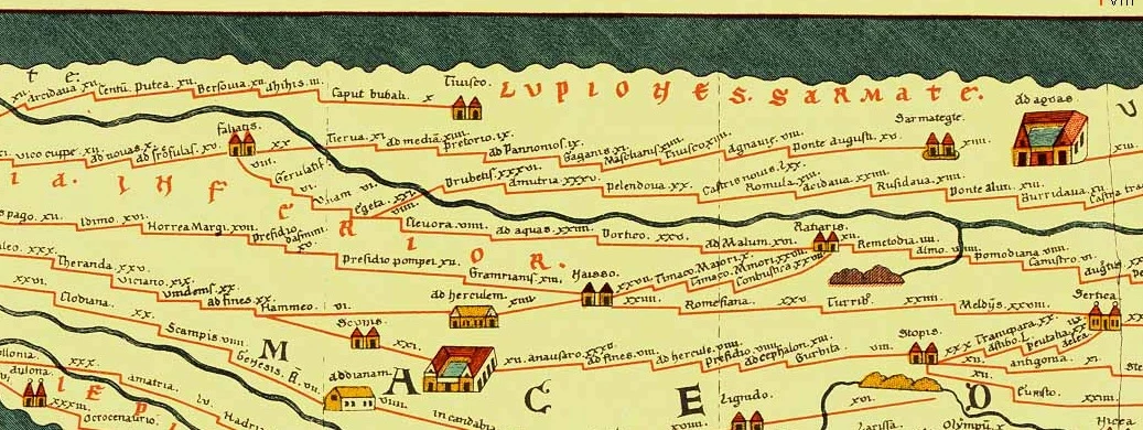

Eleven names, one by one
Each station gets a verdict. Revived means today's name was officially restored after centuries of forgetting. Shifted means the old name lives on a river or a neighbouring village, not on the town. Lost means nothing remains.
- revived
- shifted
- lost
0 untouched · 2 revived · 3 shifted · 6 lost
Eleven stations.
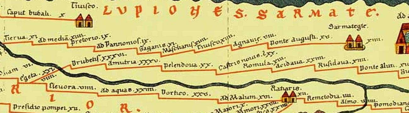
-
Drobeta
Drobeta-Turnu Severin
On the map: Drubetis
revived
A Dacian and Roman town at the head of Trajan's bridge over the Danube. In the Middle Ages the ancient name was lost and the town was called Turnu Severin. Only on 15 May 1972 did the state glue the ancient name in front of the medieval one: Drobeta-Turnu Severin. Over a millennium and a half of forgetting, erased by decree.
On the map it opens the Oltenian road, XXXVI miles to Amutria.
-
Dierna
Orșova · Cerna
On the map: Tierna
shifted
A Danube fort and harbour on the site of today's Orșova. The town lost its ancient name, replaced by the Slavic Orșova. But Dierna had taken its name from the river Cerna, and the river still carries it: the old name lives on water, not on land.
On the map, XI miles from the previous station; the road to Sarmizegetusa leaves from here.
-
Ad Mediam
Mehadia?
On the map: ad media
shifted
The name means "at the middle", probably the middle of a road. The historian Xenopol saw in it the origin of Mehadia, but most linguists derive today's Mehadia from the medieval Hungarian Michald, recorded in 1323. Meanwhile archaeologists have moved the station's site to Băile Herculane, and the Mehadia fort counts as the next station. The link with Mehadia remains a handsome tradition, not a settled fact.
XIIII miles from Tierna.
-
Praetorium
—
On the map: Pretorio; site: the Mehadia fort
lost
An empire-wide generic name: the praetorium was the headquarters, the commander's residence. Dacia had several stations of this name. The Mehadia fort, excavated under Doina Benea, keeps its walls, but the name died without a trace.
IX miles from Ad Mediam.
-
Ad Pannonios
—
On the map: ad Pannonios; site: Teregova
lost
"At the Pannonians", probably after a Pannonian unit stationed here. The fort stands at Teregova, in the Timiș valley. Today's place name keeps nothing of the Roman one.
IX miles from Praetorium.
-
Gaganae
—
On the map: Gaganis; site: not securely located
lost
The most mysterious station on the road: known only from the map, somewhere in the Timiș valley between Teregova and Tibiscum. Neither its exact site nor the meaning of its name is settled. Eleven miles of parchment lead to a place archaeology is still looking for.
XI miles from Ad Pannonios.
-
Masclianis
—
On the map: Masclianis; site: not securely located
lost
The second station with no address: also in the Timiș valley, fourteen miles short of Tibiscum. Like its neighbour, it exists only as ink on parchment. Two of the eleven names do not even have a certain village beneath them.
XIIII miles from Gaganae.
-
Tibiscum
Jupa · Timiș
On the map: Tiuisco
shifted
A Dacian town recorded by Ptolemy, then a Roman fort and municipium at Jupa, near Caransebeș. Here our road joined the one coming from Lederata on the Danube. The town's name died with the town, but the river it was born on, the Tibiscus, still flows as the Timiș.
XIIII miles from Masclianis; the junction where the two Dacian roads meet.
-
Pons Augusti
—
On the map: Ponte Augusti; site: Voislova
lost
"The bridge of Augustus": an imperial bridge guarded by a small fort at Voislova. The bridge is gone, the fort is a ruin, and the name, the grandest on this road, left no heir.
XV miles from Agnaviae, the longest leg of the road.
-
Sarmizegetusa
Sarmizegetusa
On the map: Sarmategte
revived
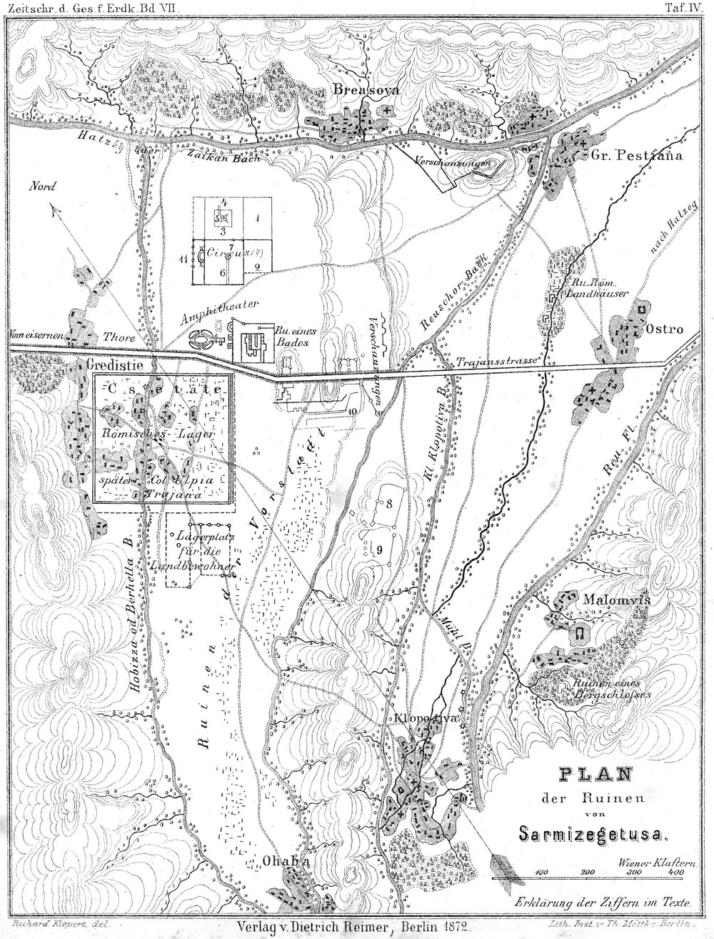
Colonia Ulpia Traiana Augusta Dacica Sarmizegetusa, the capital of Roman Dacia. The medieval village on the ruins was called Grădiște. After scholars showed this was the ancient capital, the state officially changed the name to Sarmizegetusa in 1941. On the 1872 plan of the ruins, reproduced below, the village is still called Gredistie.
XIIII miles from Pons Augusti; the road runs on toward Apulum.
The reckoning is harsh: the lost names are the small ones, halts between forts. The shifted names live on rivers, which change masters less often than towns. And the revived names are the two ends of the road, brought back by scholars and the state after centuries in which nobody spoke them.
The road on the ground
On the map, the road is a broken red line. On the ground, it is the Cerna–Timiș corridor: from Orșova up the Cerna, past Băile Herculane, then over the watershed into the Timiș valley, through Teregova toward Caransebeș and Jupa, and from there up the Bistra valley, through Zăvoi and Voislova, into the Hațeg depression.
The miles on the parchment add up: from Tierna to Sarmategte, the copyist strings 108 Roman miles, about 160 of today's kilometres. Each leg is a short day's march or a long day's cart ride: between eight and fifteen miles, depending on the climb.
The road was guarded by forts: Dierna, Praetorium, Ad Pannonios, Tibiscum, Pons Augusti. At Jupa, near Caransebeș, the ruins of Tibiscum form an archaeological reserve. At Mehadia, the walls of Praetorium emerge from the digs. Elsewhere, the Roman line fades beneath highways and fields.
Both ends got their names back
Drobeta and Sarmizegetusa are the only names on the strip you can read today on a place sign. Both were restored by the modern state: Sarmizegetusa in 1941, replacing Grădiște, after archaeologists proved this was the capital of Dacia; Drobeta in 1972, glued in front of Turnu Severin.
The plan below, drawn by Richard Kiepert in 1872 for the Berlin Geographical Society, shows the ruins of Sarmizegetusa when the village was still called Gredistie. The ancient name lived only in books. Today it lives on the station, the town hall, and the signposts.
The moral of the strip is simple: none of the eleven names survived nineteen centuries untouched. Two were saved by scholars, three took refuge on rivers and neighbouring villages, six perished. The map holds them all together, in red ink, on 34 centimetres of parchment.
Sources
Map readings are checked twice: against Florin Fodorean's transcription and against a reading of the facsimile. Station-name renderings are by Marius Comper.
- Florin Fodorean, "Tabula Peutingeriana and the Province of Dacia", Acta Musei Napocensis 39–40/I (2002–2003): the transcription of segments VII–VIII and the count of places. biblioteca-digitala.ro
- Tabula Peutingeriana, Konrad Miller edition 1887, in the Bibliotheca Augustana: the scans of segments VI–VII and VII–VIII, read station by station. tha.de/~harsch
- Encyclopaedia Britannica, "Peutinger Table": the copy's date (1265, a monk of Colmar), dimensions (6.82 × 0.34 m), eleven sheets of twelve, Celtis 1494, Peutinger. britannica.com
- The Austrian UNESCO commission: the 2007 Memory of the World inscription; the only surviving map of the cursus publicus. unesco.at
- Wikipedia: "Tabula Peutingeriana" (en). en.wikipedia.org/wiki/Tabula_Peutingeriana
- Doina Benea and the Banatica team: the Praetorium fort at Mehadia; Ad Mediam at Băile Herculane. banatica.ro
- Wikipedia: "Ad Pannonios" at Teregova, "Pons Augusti (castra)" at Voislova, "Tibiscum" at Jupa, "Dierna (castra)". en.wikipedia.org/wiki/List_of_castra_in_Romania
- Wikipedia: "Mehadia", the disputed etymology (Xenopol, Poghirc, Hungarian Michald 1323). en.wikipedia.org/wiki/Mehadia
- Wikipedia: "Drobeta-Turnu Severin", the restoration of the Drobeta name on 15 May 1972. en.wikipedia.org/wiki/Drobeta-Turnu_Severin
- The Hunedoara county planning memoir: the renaming of Grădiște to Sarmizegetusa, 1941. cjhunedoara.ro
- M. Buza, "Toponimia geografică", Revue Roumaine de Géographie 55/1: Dierna become Orșova, Agnaviae become Zăvoi. rjgeo.ro