Niger, the Ténéré desert · the shore of a lake that is gone
The Green Sahara: lakes, hippos and cattle herders where today there is only sand
Between 9,500 and 4,900 years ago, people fished on the shore of a lake in Niger, later kept some cattle, and buried their dead there. Today the same ground is dune and dry lake mud. Drag the clock below, or press Play, and watch the water, the animals and the people go.
Scroll ↓
Gobero: a lake shore with about 200 graves
In the Ténéré desert of Niger, archaeologists found about two hundred graves on the edge of a dry lake. While people lived on its shore the lake was shallow, no more than 3 metres deep and 3 kilometres across; at times it rose past 5 metres and covered the dunes where they buried their dead. The graves belong to two peoples, with a gap of about a thousand years between them in which almost nothing at Gobero has been dated.
Scroll, or drag the clock. Tap an animal or a person in the picture to see what was dug up and how sure the date is. The picture is an illustration; the finds are not.
Solid silhouette: a find from this period, dated or found in its layers. Tap it to see which.
Faded silhouette with a light outline: found on the old lake floor, no date at all
Illustration: sky, grass, trees, how people look, how many animals
First period: graves, 7700–6200 BCE
No dated grave or bone, 6200–5200 BCE
Second period: graves, 4930–2760 BCE
Lake end undated, 2500–1900 BCE
About 9,500 years ago: people nearly two metres tall, and fish as long as they were
The oldest dated graves at Gobero are from about 7500 BCE; the excavators call it the earliest recorded cemetery in the Sahara. The people buried there were tall, “approaching two meters”. They fished with bone harpoons. Later in this period, about 8,600 years ago, Nile perch vertebrae from the lake sediment (6640–6430 BCE) come from fish up to two metres long, which, the authors say, suggest permanent, well-aerated water five metres deep or more. Part of a hartebeest, a large antelope, from the lake floor is dated 6690–6580 BCE.
From about 6200 to 5200 BCE: a thousand years with nothing dated
In this stretch the team found no dated bone, grave or lake sediment at Gobero; the only dated material inside it is a cluster of small snail shells. The authors read this as a harsh dry spell in which the lake seems to have dried out and people left. Nothing at Gobero measures the drought itself, but rainfall records from two sea-floor cores off West Africa (19°N and 23°N) indicate, by modelling, a dry spell of at least a thousand years at about the same time.
About 6,900 years ago: the shore fills again, with a different people
From about 4900 BCE new graves appear (the authors round the start to about 4600 BCE, averaging two dates on one grave). These people were shorter and slighter. Their refuse heaps hold clams, catfish and tilapia, and bones and teeth of hippos, crocodiles and a small antelope. The authors think a new people replaced the old one after the dry spell. It is their most likely explanation, not something anyone saw.
One grave holds a woman and two children of about eight and five. Their arms, hands and legs are intertwined, and the authors suggest they died nearly together. The authors find no sign of a violent traumatic death. The grave is dated 3500–3130 BCE by tooth enamel; a bone of the woman gives 2860–2490 BCE. Cattle bones are rare at Gobero; the authors read this as an economy leaning on fishing and hunting, and say herding and grain may also have mattered.
Between their arms, the team found clusters of wool-flower pollen (Celosia), 32.4% of the grains in that one sample. The authors do not say anyone laid flowers there; the pollen is what was measured.
A photograph of human remains from the excavation. It is shown with the excavators' own caption.
The triple burial, cropped from Fig. 5E of Sereno et al. 2008 (CC BY). Their caption: the adult woman facing the two juveniles.
After 2500 BCE: the lake ends, and nobody dated when
The last traces at Gobero are pots and a hearth, probably left by mobile cattle herders. A pot lying on the old lake floor at one spot is dated 2130–1900 BCE, so the water had left that spot by then; the paper gives no date for the lake’s end. On the map below, other records place the end of the rain anywhere between about 5,300 and 750 BCE, depending on where you stand and what you measure.
About 200 graves, 67 of them excavated. Early graves from about 7500 BCE (oldest dated 7730–7580 BCE), later graves 4930–2760 BCE.
Dated directly Teeth and bones
Herders, drawn with their cattle
No grave says “herder”. Cattle bones are rare at Gobero, so the people shown beside them are an illustration.
Drawn (illustration)
Hippopotamus
Bones and teeth in the refuse heaps of both periods, and a hippo-ivory arm bracelet in one grave. No hippo bone has itself been radiocarbon dated.
Found in this period’s layers
Crocodile
Present in both periods. One harpoon point was cut from a crocodile jaw. The only dated crocodile bone is one scute from the lake floor, 2480–2290 BCE.
Found in this period’s layers
Nile perch
Vertebrae from fish up to two metres long. Three are dated: 6640–6240 BCE, in the first period.
Dated directly
Hartebeest
Part of a skeleton from the lake floor, dated 6690–6580 BCE.
Dated directly
Kob (an antelope)
Found in the early-period refuse area. Not itself dated.
Found in this period’s layers
Cattle
One animal dated twice (tooth enamel 3940–3660 BCE, jaw bone 3790–3640) and a leg bone dated 2900–2670. “Only a minor component” of the finds.
Dated directly
Giraffe
Bones found on the old lake floor and on the wind-scoured surfaces nearby. No date and no period; we draw them in both periods, which no find shows.
Found, no date
Elephant
Bones found on the old lake floor and on the wind-scoured surfaces nearby. No date and no period; we draw them in both periods, which no find shows.
Found, no date
Wool-flower pollen
Clusters of Celosia pollen, 32.4% of one sample, from the soil between the arms of the triple burial. The grave is dated 3500–3130 BCE (tooth enamel); a bone of the woman gives 2860–2490 BCE. The authors do not say flowers were laid.
Green wash: the belts where the sources say the rain failed, between the dates shown. It is an outline of those findings, not a vegetation map.
Did the rain stop everywhere at once?
No. Gobero is one lake. Around it, other records tell the story of the rain, and they disagree about when it ended. Not by a little: by thousands of years.
Green wash: the belts where the sources say the rain failed, between the dates shown. It is an outline of those findings, not a vegetation map.
Seven records, seven endings
Each pin turns from rain-fed to dry at the date its own record gives. They are different kinds of evidence: houses and hearths, lake mud, pollen, dust on the sea floor. Drag the clock and see which goes first.
How fast did it end? A few centuries here, nearly three thousand years there
At Lake Yoa in Chad the lake itself turned from fresh to salt in about 300 years, while the plants around it changed over almost 3,000. Dust on the Atlantic floor jumped in under four centuries. Models of four rain records from the African coast suggest the end was “likely abrupt (occurring within a few hundred years)”. These do not contradict each other: the answer depends on what you measure and where.
North of 15°N the rain ended earlier than south of it
A study of records across Africa finds the end of the humid period “locally abrupt” but later further south: 5,000 to 6,000 years ago north of 15°N, 2,500 to 4,000 years ago south of it. Not every record agrees: between 19°N and 27°N on the Atlantic coast the authors of one study “do not see a clear time transgression”. Not every pin follows the rule: Lake Mega-Chad, south of 15°N, fell about 5,000 years ago, and Lake Yoa, north of it, kept its plants until about 2,700 years ago.
Whether a collapse can look gradual in some records and sudden in others. Whether the rain at the northern edge, around 31–32°N, came from the summer monsoon, as Tierney reads it, or from winter storms off the Mediterranean, as Cheddadi and colleagues argue from a lake at 32°N. Whether part of the north-south delay is only the wind having scoured away the youngest mud in the driest places. Each of these is a published disagreement, and none is settled.
A lake the size of the Caspian Sea, in the middle of Africa
Lake Mega-Chad
Where the Sahara meets the Sahel, in the basin around today’s small Lake Chad, there was once a lake of about 360,000 square kilometres at its main shoreline. At its peak it was “at least 400 000”, which the researchers who mapped its old beaches call “bigger than the Caspian Sea”. NASA says “slightly larger”.
We filled the terrain model up to 329 metres, the mean height of the old shoreline in Drake and Bristow’s survey. On this coarse grid that gives about 373,000 km², against their 361,000. The outline is a static water level, not a hindcast. It overflowed through the Mayo Kébi River into the Benue and on to the Atlantic. Armitage and colleagues, dating buried sand grains by the light stored in them, put the highstand at about 11,500 to 5,000 years ago, give or take centuries, without giving its level in their abstract; Drake and Bristow place the 329 m stage at about 7,500 to 7,000 years ago. The lake fell rapidly at about 5,000.
Where people lived: settlement stops “abruptly in all areas without permanent water”. It is inferred from missing sites; the authors call the drying gradual, with full desert by about 3500 BCE.
Not later than about 5300 BCE
Gilf Kebir plateau, Egypt
A refuge: people retreated here between about 5300 and 3500 BCE. The Cave of Swimmers is here.
About 3500 BCE
Gobero, Niger
Lake shore and graves, drawn from the clock.
Dry gap 6200–5200 BCE; last grave 2835 BCE; lake end undated
Lake Yoa, Chad
Pollen in the lake mud: trees thin out, then grass, then desert plants. The lake itself is still there.
3650 BCE to 750 BCE, gradually
Sea floor off Mauritania
Sahara dust blown onto the ocean floor suddenly increases.
About 3550 BCE, in under four centuries
Sea floor off Morocco, 31°N
Rainfall reconstructed from leaf wax: “very wet conditions as far as 31°N”, which the authors judge likely to be mostly monsoon rain.
About 4550 BCE
Lake Mega-Chad
The largest lake of the green Sahara; see the next section.
Falls at about 3050 BCE, split in three by 2050 BCE
How long the end took, record by record
Lake Yoa, Chad: the lake turns from fresh to salt
about 300 years · about 12 generations
Sea floor off Mauritania: Sahara dust jumps
under 400 years · under 16 generations
Four rain records on the Atlantic coast
“a few hundred years” · about 12 generations
Lake Yoa: the plants around it, from first drying to modern desert
about 2,900 years · about 116 generations
One generation counted as 25 years. The cores give no exact length for the fall: where a source says “a few hundred”, the bar shows three hundred.
Rock art cannot be dated like a bone. What it shows is a country with cattle, giraffes and people in motion; when each picture was made is mostly an estimate.
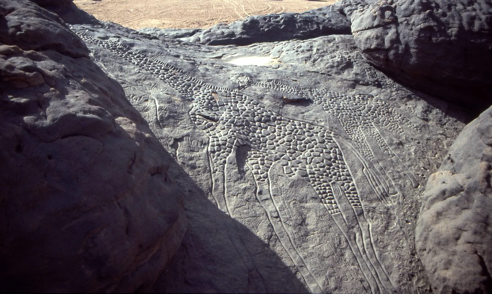
Two giraffes, one over 18 feet tall At Dabous, in the Aïr mountains of Niger, two giraffes are engraved side by side in sandstone. The larger is over 18 feet (5.5 metres) tall. The Bradshaw Foundation reports an estimate of 7,000 to 10,000 years from the rock-art specialist Jean Clottes, and no direct date. Which culture made the engraving is not known.Credit: Albert Backer, Wikimedia Commons, CC BY-SA 3.0
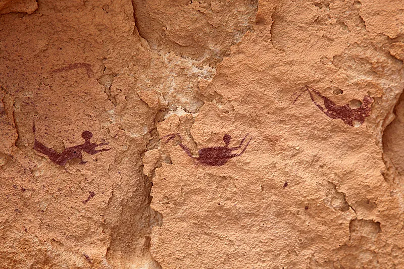
The Cave of Swimmers: do they swim? The painted figures in a shelter in the Gilf Kebir, Egypt, look like swimmers. The explorer László Almásy, who found the caves in 1933, thought they showed real life in a wetter time. A specialist who studied them puts “swimming” in quotation marks and calls the figures, through a journalist, “clearly symbolic”. Carbon-dated lake deposits about 200 kilometres south, at Gebel Uweinat, are 8,100 and 9,400 years old; the paintings are about 7,000 years old, give or take a thousand (Bradshaw gives about 8,000).Credit: Roland Unger, Wikimedia Commons, CC BY-SA 3.0 (and 2.5, 2.0, 1.0)
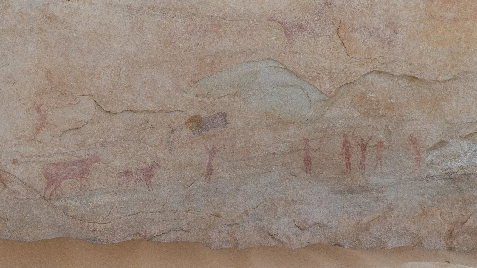
Cattle and herders, Tassili n’Ajjer Painted herds appear across the Sahara. The cattle style may have lasted from around 7,000 to 4,000 radiocarbon years ago, but the authors of a study of milk residues in Saharan pottery write that “reliable dates for this rock art can rarely be ascertained”.Credit: IssamBarhoumi, Wikimedia Commons, CC BY-SA 4.0
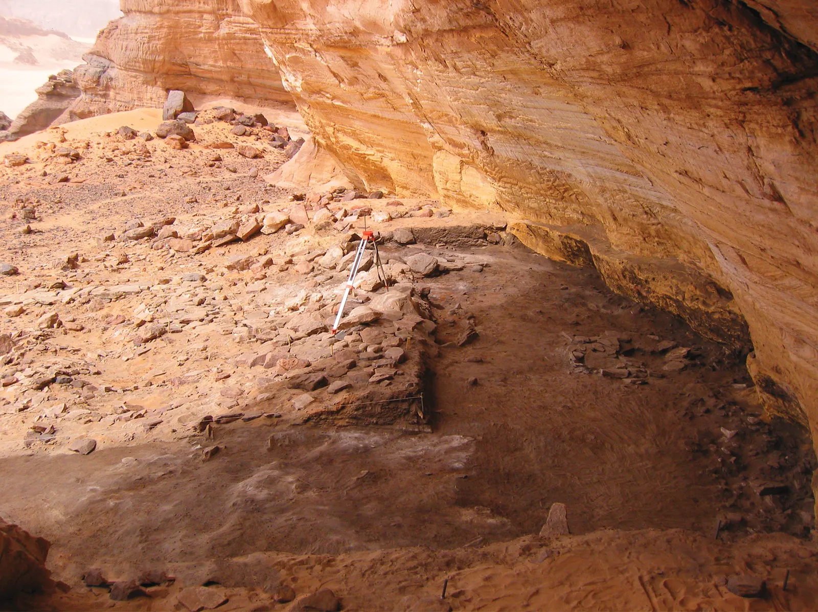
Milk in the pots, Takarkori In the Takarkori rock shelter in Libya, chemists found milk fat in pottery from the Middle Pastoral period, about 5200 to 3800 BCE: the first unequivocal chemical evidence of dairying in Saharan Africa, in the words of the 2012 study.Credit: Van Neer et al., PLoS ONE 2020, Fig. 5B, CC BY 4.0
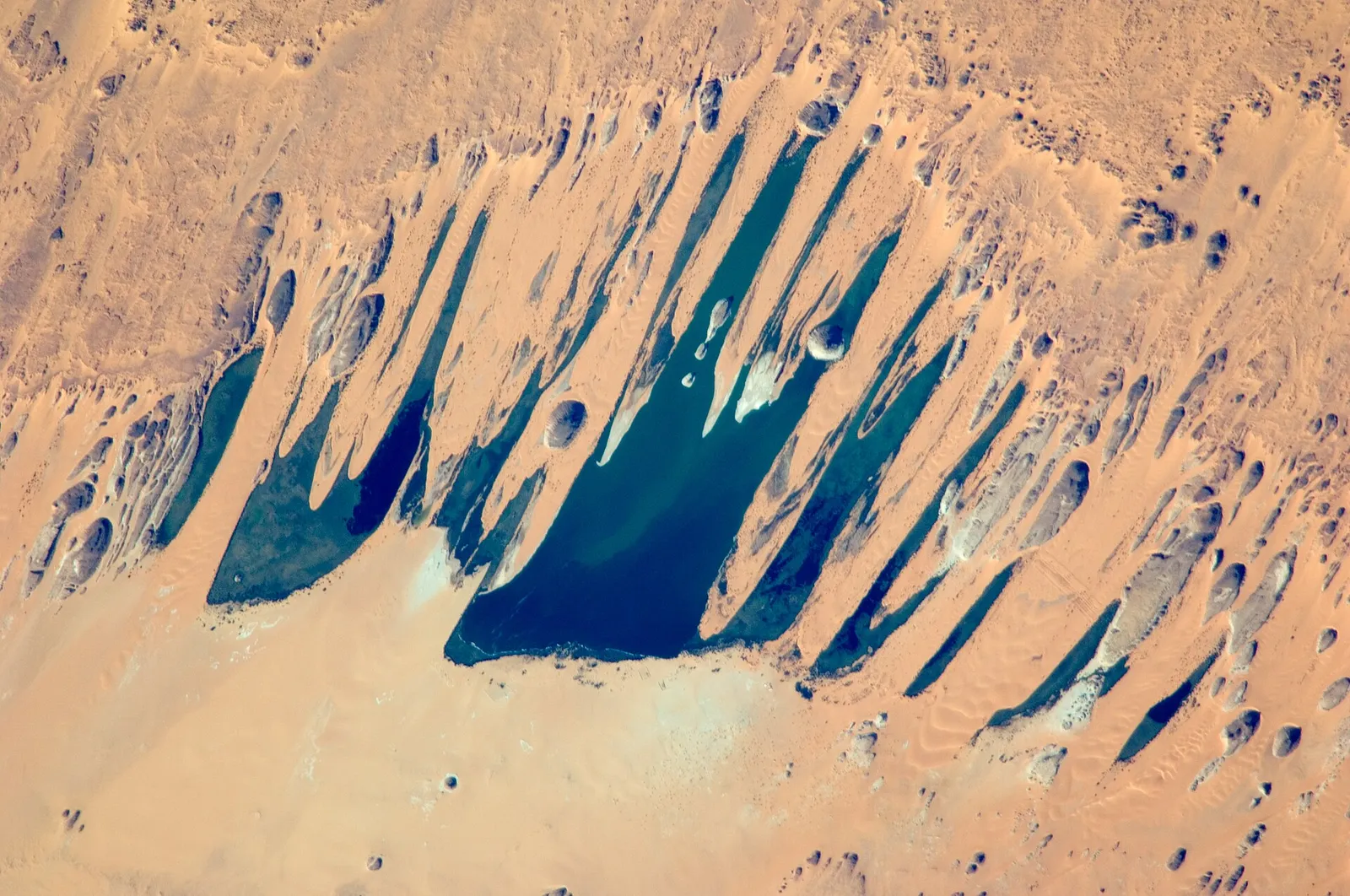
Lake Yoa, in the Ounianga lakes of northern Chad, is still full. Groundwater from the Nubian Sandstone Aquifer, last recharged in the early Holocene, keeps it so; it has held water throughout the dry period. It lies in the middle of the Sahara.
Credit: NASA, Johnson Space Center, ISS021-E-26475 (public domain)
Crocodiles were widespread across the Sahara from the mid-Holocene, and still lived there in Roman times. Today small relict populations survive in the Ennedi mountains of Chad and in Mauritania, where crocodiles were detected at 78 places and, where they were counted, mostly fewer than five at a time.
The excavators of the Egyptian Sahara write that people were “forced to the Nile valley or ecological refuges” and to the Sudanese Sahara, where rain was still enough. A study of 3,287 radiocarbon dates finds the late populations moved southwest. Some accounts say Saharan refugees founded Egypt. Kuper and Kröpelin argue that the drying “helped trigger” the rise of pharaonic civilisation and that some of its cultural traits go back to Saharan cattle herders, while the first farming villages of Egypt, at Fayum and Merimde, “are clearly rooted in Near East traditions”. How much the exodus shaped Egypt remains a hypothesis.
A slow change in the direction Earth’s axis points, called precession, made northern summers about 8% sunnier than today at the peak, some 10,000 years ago, and the African monsoon rains moved north. The sunlight faded gradually; the rain left much faster in some places than in others.
What is measured, what is read into it, what is drawn
Measured
The dates of graves, bones and sediments at Gobero, with the labs' uncertainties.
The rain, pollen and dust records, their dates and where they were taken.
The height of the old shorelines of Lake Mega-Chad, and the terrain we filled.
Read into it by the authors
That a dry spell caused the thousand-year gap, and that a new people replaced the first.
That the triple burial’s three people died almost together.
That the late pots were left by mobile herders.
That the end of settlement in the Egyptian Sahara marks the end of the rain there.
Drawn by us
The sunset, the sky, the grass and the trees.
How the people look, what they wear and how many there are.
How many animals stand where. We draw a herd where the finds say “present”.
How high the lake stands at each moment and when it vanishes, and the herder beside the cattle.
The green wash on the map and the fade of Lake Mega-Chad between its two dates.
Years are calendar years. Radiocarbon dates are the calibrated ones the papers print; a date given as years before 1950 becomes 1950 minus that number, and “years ago” counts from 2026, rounded. Dates the papers give in thousands of years (such as 5,000 or 11,500) are used as printed; their uncertainty is centuries. Gobero’s position is approximate: the paper gives it only as about 150 km southeast of the Aïr mountains.
Sources
Sources used on this page. Each sentence about a find or a date comes from one of them.
Wikimedia Commons photographs: names and licences are beside each picture.
Gobero photograph: Sereno et al. 2008, Fig. 5E, cropped, CC BY.
Silhouettes from PhyloPic: Hippopotamus amphibius, Evan Boucher (CC0); Giraffa camelopardalis, Bernard Dupont and T. Michael Keesey (CC BY-SA 3.0); Bos primigenius, DFoidl, modified by T. Michael Keesey (CC BY-SA 3.0); Alcelaphus buselaphus, TeaandBiology (CC0); Loxodonta africana, Steven Traver (CC0); Kobus ellipsiprymnus, Jan A. Venter, Herbert H. T. Prins, David A. Balfour and Rob Slotow, vectorized by T. Michael Keesey (CC BY 3.0); Lates niloticus (public domain).
Relief: Terrarium elevation tiles (Mapzen and Amazon open elevation data, from SRTM, GEBCO and other sources). Lake outline: Copernicus DEM GLO-90.