
Timișoara, Romania · the fortress, the Esplanade and the districts
Timișoara, the city kept at a distance by its own fortress
Until 1868 building was forbidden within 500 Klafter (Viennese fathoms), or 948 m, of the fortifications of Timișoara, the city in western Romania that its Habsburg builders called Temeswar. The plan of 1853, laid here over today’s streets, shows that circle: the suburbs of the time stop at it, the old parks round the centre lie inside it, and Bulevardul Cetății, “Fortress Boulevard”, still runs along its edge.
Find a street on the mapor scroll: the plan of 1853, the star of 1788 and what is left of themtoday
From Piața Unirii to Piața Traian you walk through a park and cross a canal#
Cetate (“the Fortress”, the old walled town), Fabric, Iosefin, Elisabetin and Mehala are districts of one city. Yet between Cetate, in the middle, and the others lies a wide band of parks, boulevards, campuses and sports grounds: between Piața Unirii, the main square of Cetate, and Piața Traian, the centre of Fabric, lie Parcul Regina Maria and the Bega canal. On the map the band is almost round.
Its shape comes from a military rule that held from the middle of the 18th century until 1892.
1853
The plan of 1853: a white star, an empty ring, the suburbs beyond it#
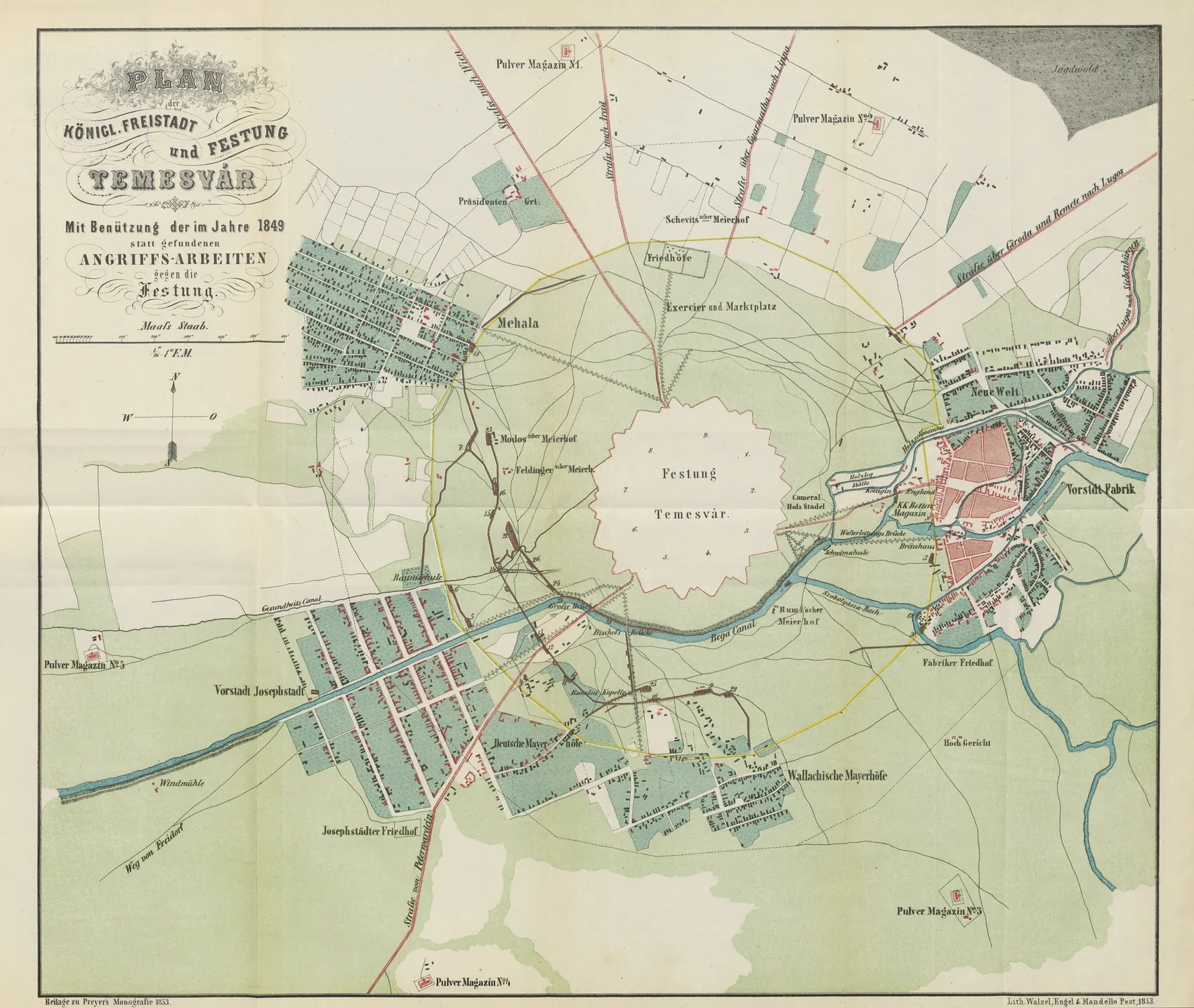
Johann Nepomuk Preyer, the mayor, published this plan in his 1853 monograph on the town. The fortress is left white, in the middle. Around it is green: pasture and drill ground. Only at the edge of the green do the coloured blocks begin, under the names on the plan: Fabrik (Fabric) to the east, Josephstadt (Iosefin) to the south-west, the Maierhöfe (later Elisabetin) to the south and the village of Mehala to the north-west.
Here the plan sits on today’s streets. It was fitted to the streets that already existed then, in all the suburbs at once. Fitted to Iosefin alone or to Mehala alone it would move by 12 m at most; to the Maierhöfe alone, by 19 m; to Fabric alone, by 36 m.
1853
The yellow line runs 500 Klafter from the fortress#
A yellow polygon runs round the fortress, with a small circle at each corner. The plan gives it no name. Measured on the plan’s own printed scale, the line lies 934 m from the outline of the fortifications; measured on today’s streets, 971 m. Between the two falls the military engineers’ round number: 500 Viennese Klafter of 1.896 m each, which is 948 m.
The name comes from an army plan of 1772: the “Esplanade”, drawn in red 500 Klafter out from the outer angles of the covered way, the sheltered path along the outer lip of the ditch, and marked on the ground with a wooden post at every corner. Inside it building was forbidden. Yet the same plan numbers, one by one, the houses and huts that stood there all the same, each with its owner and what it was built of.
Preyer’s text does not name the yellow line either. That it is the edge of the Esplanade follows from its distance, from its shape as a polygon with marked corners, and from the plan of 1772.
1853
The blocks stop at the line#
Of the area of coloured blocks on the plan, 3.5% falls inside the line: a few gardens with houses by the great bridge over the Bega and towards the Rosalia chapel. The rest begins where the Esplanade ends.
Most of the town lived outside the walls. In the census of 1851 the fortress held 4,574 people and Fabric 10,906: 53% of the town. Iosefin had 2,881, the Maierhöfe 2,199.
1788
The star of 1788: nine bastions, three lines of walls#
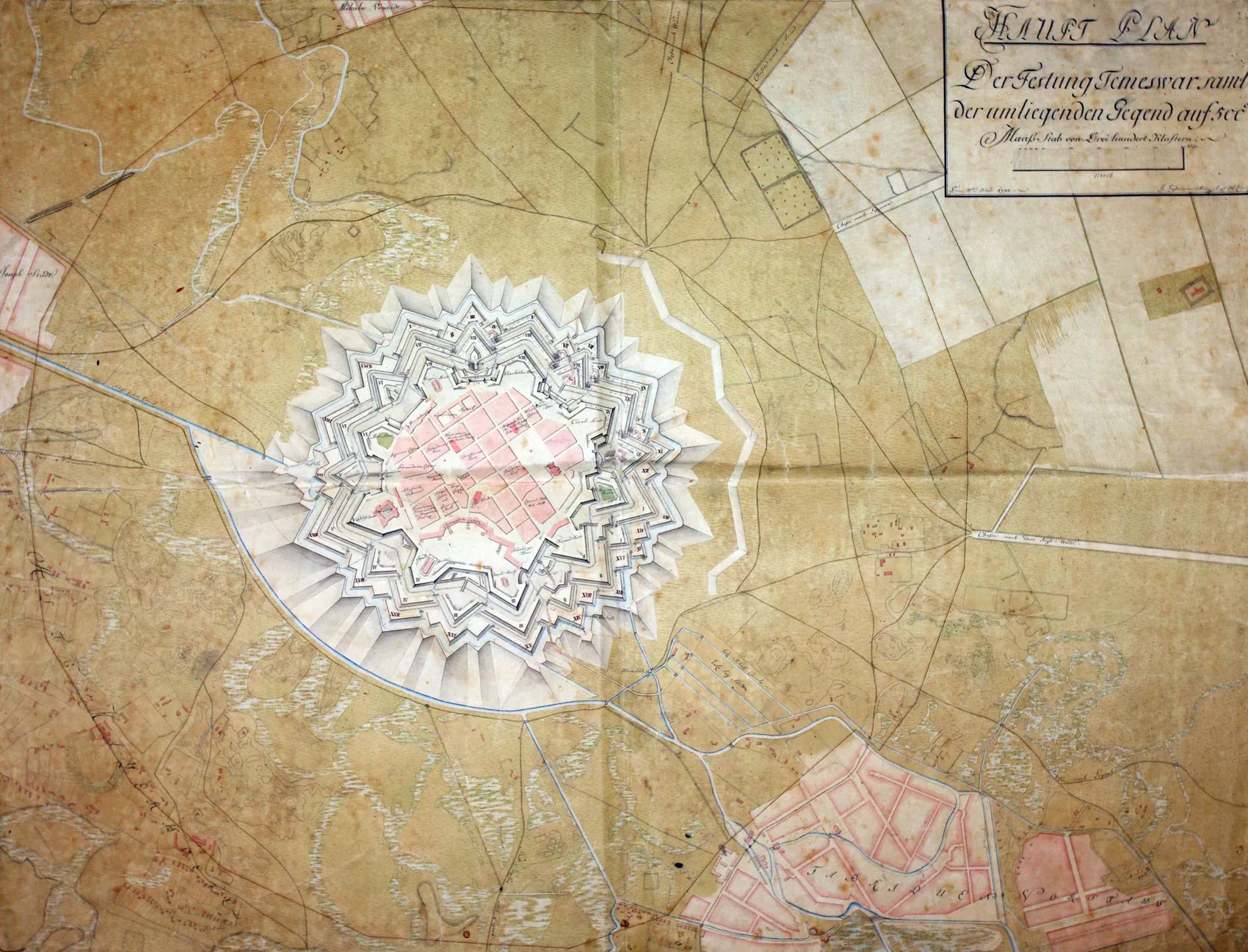
“Main plan of the fortress of Temeswar, with the surrounding country to 500 Klafter”, is the title of this plan, drawn and coloured by hand in 1788. The Habsburgs had taken Timișoara from the Ottomans in 1716 and rebuilt it as a star fortress. It had been finished in 1765, after more than four decades of work: the foundation stone was laid on 25 April 1723 and the ditch of the main enclosure was begun in 1732.
The plan is set on the streets of Cetate, which have not moved since. Huniade Castle is drawn 13 m from where it stands, and the surviving pieces of wall fall on the bastions and connecting walls they once belonged to. The belt of bastions and of the outworks in front of them, ravelins and counterguards, took up more ground than the town it defended.
1849
Why so much empty ground: the guns had to see#
A bastioned wall defends only if its artillery has a clear field; a house within range shelters the besieger. In the Maierhöfe houses were tolerated only provisionally, and their owners signed a “revers”: they accepted demolition on order, without compensation.
The rule was tested in 1849, when the army of the Hungarian revolution besieged the fortress from April to August. Preyer, mayor at the time, writes that the suburbs had come “in part onto the Esplanade” and helped the besiegers to approach. On 17 June the fortress guns fired 400–500 shells into Iosefin and the Maierhöfe. The brown lines on the plan are the trenches and batteries of that siege.
1869
Across the gap: roads winding between bastions, and a horse tram#
The gates were reached by narrow passages that wound round the bastions and by bridges over the ditches. Between Cetate and Iosefin there was a single road, which the railway crossed from 1857.
On 8 July 1869 a horse tram began to run between Piața Sfântul Gheorghe, in Cetate, and Fabric. For it the army allowed a third opening in the gates. The old road to Fabric, marked on the map, is today’s Bulevardul 3 August 1919.
1868
1868: the circle tightens to 300 Klafter#
At the town’s repeated request, an imperial resolution of 10 November 1868 cut the ban from 500 to 300 Klafter: 569 m. The ring thus freed, 200 Klafter wide, passed to the town, except for the great drill ground, which was also the fairground.
The War Ministry set a condition: new streets had to run radially, towards the fortress, so that they could be seen from the walls and swept by the guns along their whole length. An older duty of the town stayed too: the trees of any park on this ground were to be felled at the army’s demand in case of war, without compensation.
The date 10 November 1868 comes from Josef Geml, the town’s chief notary, who in the same text also mentions the year 1869.
today
The streets that aim at the fortress#
On today’s map, in the ring freed in 1868, 28.1% of the length of the streets aims at the fortress, within 15° either way. If streets pointed at random it would be 16.7%. On the map, red streets are radial and blue ones go round the fortress.
The condition of 1868 does not explain all of it, though. Just beyond the old 500-Klafter line, in suburbs older than the rule, the share is higher still: 32.8%. The old suburbs, too, point their streets at the fortress more often than chance would.
1892
1892: Timișoara stops being a fortress#
Permission to pull down the gates came first, in 1891, for the crowds of that year’s exhibition. In 1892 Emperor Franz Joseph lifted the town’s status as a fortress; the historian Ciprian Glăvan gives 23 April, following a monograph of 1902.
Long bargaining with the army followed, from 1893 to the contract of 15 June 1905. The town received 1,380,460 m² of ground, about 138 hectares, and paid in buildings put up for the army, which cost 2,307,588 crowns (the Austro-Hungarian korona).
Ciprian Glăvan (2013) and, after him, Wikipedia give 138,460 m², with a zero lost on the way: that would be less than the town inside the walls.
1898–1911
25,819,000 bricks#
Demolition began in 1898, on the bastions the army could spare, partly as winter work for the navvies. The great walls came down after the contract. By the end of 1911 they had yielded 25,819,000 whole bricks. More than 18 million were sold, at 20–24 crowns a thousand. In dwellings they were allowed, for reasons of health, only in the foundations.
The ground filled slowly. In 1910, 18 years after the fortress was decommissioned, not one dwelling yet stood on the ground of the fortifications. In 1911 the town built 163 new houses, 29 of them with two or three upper floors, along the new avenues.
today
What stands today in the ring where nothing was built#
Between the outline of the fortress and the old 500-Klafter line there are 3,163 buildings today. In the first 300 Klafter, though, 15.2% of the area is park: 51 hectares. In the next ring it is 2.2%; further out, 1.2%.
Parcul Central (Central Park) lies on the glacis, the bare earth slope in front of the ditch: the commander Anton Scudier had his soldiers level and plant the ground in the 1870s. Parcul Regina Maria, in front of Fabric, is the city’s oldest park. Six “palaces” of the Corso, the grand apartment blocks along today’s Piața Victoriei (Lloyd, Neuhausz, Dauerbach, Löffler, Hilt, Széchenyi), rose between 1910 and 1913 on the site of the walls, and the Metropolitan Cathedral, begun in 1936, closes the row to the south.
today
Fortress Boulevard, almost a kilometre from the fortress#
To the north-west, along the edge of Mehala, Bulevardul Cetății (“Fortress Boulevard”) is 3.25 km long. For 2.21 km of that it runs less than 60 m from the yellow line of 1853.
Closer in, Calea Circumvalațiunii, Bulevardul Vasile Pârvan and Bulevardul Corneliu Coposu go round the fortress 300–400 m from its old outline.
None of the sources below says the boulevard was laid out along the edge of the Esplanade on purpose. The overlap is what the map shows.
today
What is left of the wall#
The Theresia Bastion, the fortress’s provisions store, finished in 1734, is the only one kept almost whole. By Piața Timișoara 700 part of the Eugene Bastion still stands.
A little to the south, behind the old hospital of the Misericordian friars, now the eye clinic, is a piece of the curtain wall that joined the Eugene and Mercy bastions. It escaped demolition because it was part of the hospital building. Part of it was restored and opened in 2025 as an exhibition space, Cazemata 54.
Another stub of curtain, between the Eugene and Elisabeth bastions, stands in the Botanic Park, on the Strada Gheorghe Dima side. On Calea Alexandru Ioan Cuza a piece of the wall by the Vienna Gate survives.
The rest shows only on the map: the ring of boulevards, the parks, and the distance between the districts.
Where a street lies in relation to the fortress and the Esplanade#
The same map, now yours to move. For any spot in the city it gives the distance to the outline of the fortress on the 1853 plan, which side of the 300- and 500-Klafter lines it falls on, and what was drawn there in 1853.
Pick a street or tap the map to see how far the place is from the fortress, which side of the line it falls on, and what the 1853 plan shows there.
How much of each circle round the fortress is followed by a street today#
Circles can be drawn around the 1853 outline every 25 metres. For each one, the chart shows how much of its length has a street running along it today. Usually it is about 8%.
Two circles stand out. The one about 337 m out has 34%: Calea Circumvalațiunii, Bulevardul Vasile Pârvan and Bulevardul Corneliu Coposu. The one about 987 m out has 25%: Bulevardul Cetății, Strada 1 Decembrie 1918 and Strada Bogdan Petriceicu Hașdeu. The 500-Klafter line is at 948 m by the rule and at 971 m on the plan, measured on today’s streets.
What each band around the fortress holds today#
In the first 300 Klafter, where the ban held until 1892, parks take up 15.2% of the ground; in the bands beyond, 1–2%. Buildings cover about a fifth of the ground in every band outside the walls.
| Band | Area (ha) | Buildings | Built-over ground | Parks | Parks (ha) |
|---|---|---|---|---|---|
| Inside the outline (town and walls) | 106 | 561 | 32.2% | 14.3% | 15.1 |
| 0–300 Klafter (to 569 m) | 333 | 1,279 | 18.7% | 15.2% | 50.7 |
| 300–500 Klafter (569–948 m) | 328 | 1,884 | 23.7% | 2.2% | 7.3 |
| 500–700 Klafter | 418 | 3,712 | 23.5% | 1.2% | 5.0 |
| 700–900 Klafter | 508 | 4,590 | 20.6% | 1.1% | 5.7 |
Four plans of Timișoara, from 1716 to the 1890s#
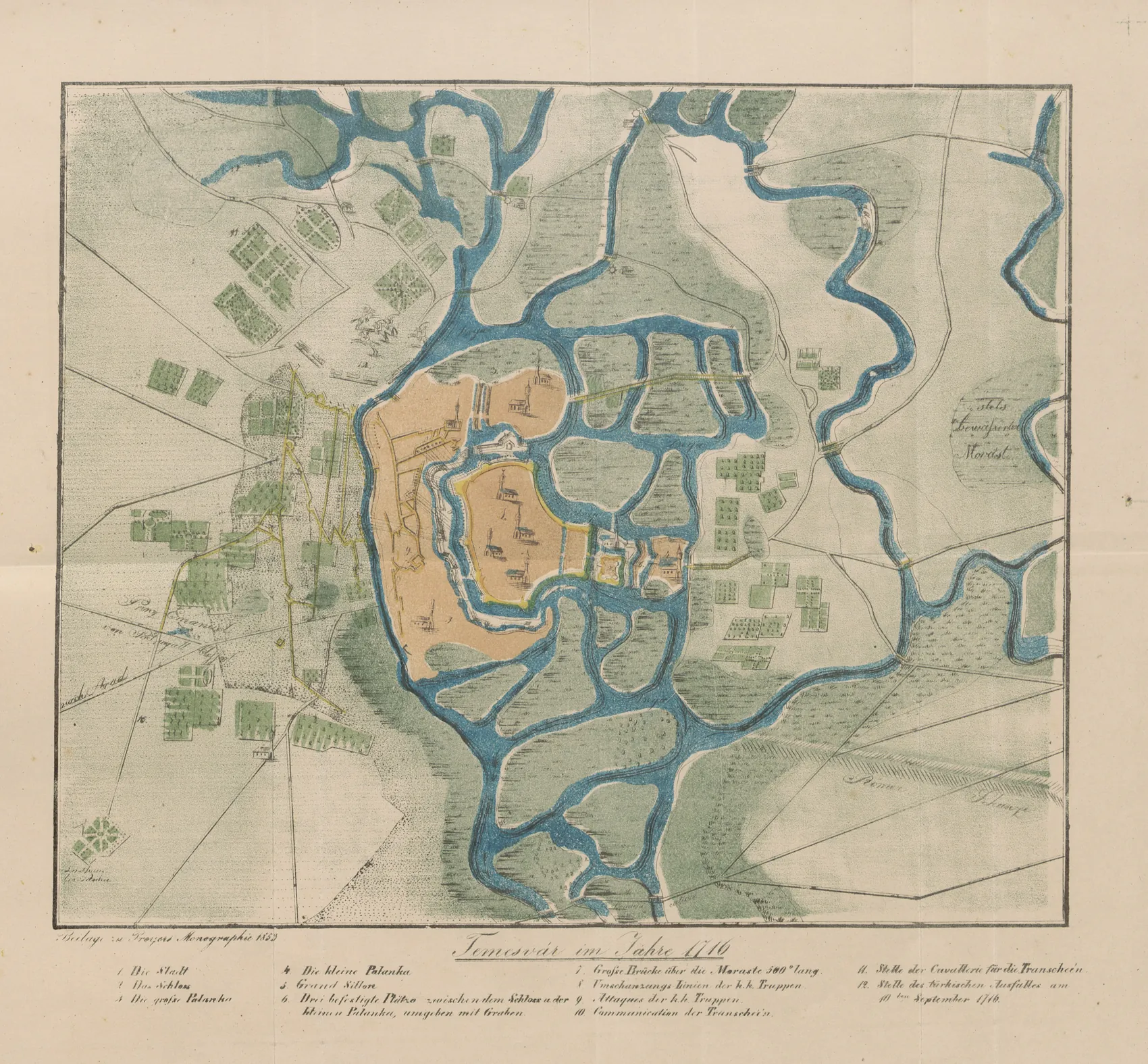
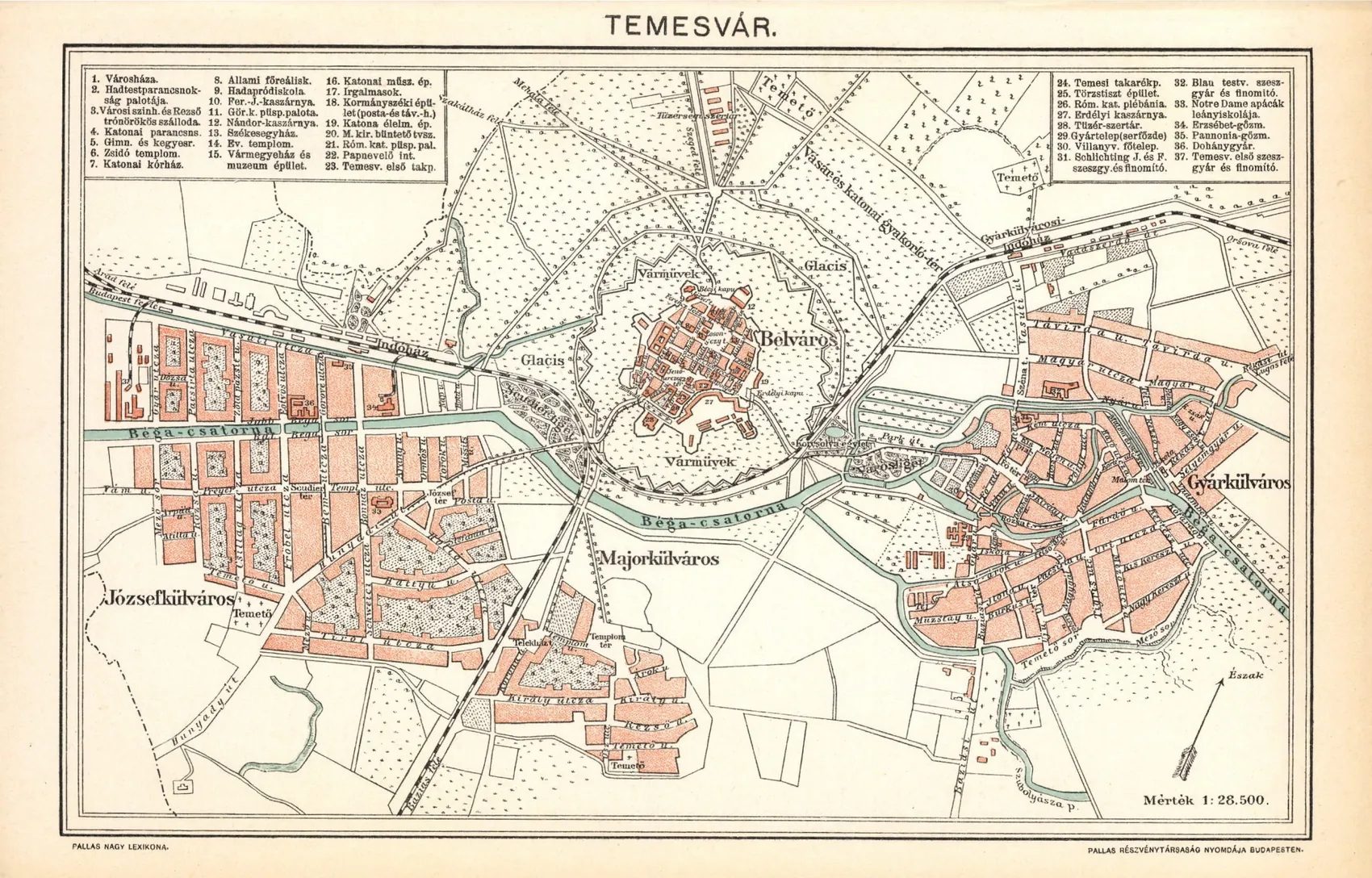
Seven dates and figures about the fortress, checked against the sources#
Several often-repeated figures about the fortress do not match their sources.
| What | As usually given | What the sources say |
|---|---|---|
| The ground the town received in 1905 | 138,460 m² (Glăvan, 2013; Wikipedia) | 1,380,460 m² (239.5 cadastral hold, the Hungarian yoke of 0.58 ha), according to Josef Geml, the chief notary, who took part in the negotiations. The small number is a zero short; where it was lost is not known. |
| Bricks recovered from the walls | almost 26 million, 19 million of them sold | 25,819,000 whole bricks by the end of 1911, when part of the walls still stood; 18,418,000 of them sold. |
| The start of the Habsburg fortress | 1722, 1723 or 1732 | Each for something different: the first works in 1722 (Geml), the foundation stone on 25 April 1723, the ditch in front of the bastions in 1732. Work ended in 1765. |
| The siege of 1716 | 43 days, ending on 12 October | The white flag went up on 12 October, the capitulation was signed on the 13th, and Eugene of Savoy entered the town on 18 October. |
| The horse tram | 8 July 1869, Fabric–Cetate–Iosefin | On 8 July the Cetate–Fabric section opened. The town’s monograph of 1914 puts the opening of the line in November 1869. |
| Palatul Weiss, on the Corso | 1912 | The plot was bought in 1910, but the army’s right of pre-emption blocked the work; the palace was built in 1926–1927, according to the city’s heritage project. |
| The first mention of Timișoara | 1212 | The charter of 1212 is disputed: it may concern another “Temes”. The first secure mention dates from 1266. |
How the plans were set on today’s map, and how sure the measurement is#
The 1853 plan. The suburbs are printed as coloured blocks with white streets between them. The streets of that time still exist, so their centrelines in OpenStreetMap must fall between the blocks. The plan was scaled, rotated and shifted until as few points as possible along today’s streets landed on a coloured block. Repeated for each suburb separately, the fit moves the plan by 12 m or less in Iosefin and Mehala, by 19 m in the Maierhöfe (Elisabetin) and by 36 m in Fabric, where the arms of the Bega have since been filled in. These shifts show how well the plan agrees with itself from one suburb to the next; they do not cover the difference in scale below.
The scale. The scale that the streets give is 4% larger than the scale bar drawn on the plan. Hence the two values for the yellow line, 934 m and 971 m. The distance is the median of all the points of the line to the outline of the fortress.
The outline of the fortress. It is the one drawn on the 1853 plan, a saw-toothed outline enclosing 106 hectares. The plan does not say what the outline is. It is taken here as the outer edge of the covered way, because the army plan of 1772 measures the Esplanade from there and the yellow line lies 500 Klafter from this outline. Josef Geml measures from the foot of the glacis, the earth slope in front of the ditch; from there the line is under 400 Klafter.
The 1788 plan. It was fitted the same way, by the pink blocks inside the walls and today’s streets of Cetate. The image is a photograph of the plan, slightly distorted at the edges, so the fit weakens towards the edges.
Today’s city. Streets, buildings, water and parks come from OpenStreetMap (extracts of May 2026 and October 2026). “Park” here means what is mapped as a park or public garden. A street counts as “radial” if its direction is within 15° of the shortest line to the outline of the fortress.
What remains to be confirmed. The title of the 1772 plan was transcribed from the image in the map collection of the Military History Museum in Budapest, not from the original. The 1851 census figures have not been compared with the printed copy; they do add up to the total in the table.
Sources#
- Johann Nepomuk Preyer, Monographie der königlichen Freistadt Temesvár, Temesvár, 1853 (British Library copy): the text, the population table of 1851 and the two plates. doi.org
- Plan Von dem Esplanade-Terrain Rings um die Haupt, und Gränitz Festung Temeswar, manuscript plan, 1772 (signed by de Babany and Carl Steinlein), Hadtörténeti Intézet és Múzeum, Budapest, G I h 669. maps.hungaricana.hu
- Haupt Plan der Festung Temeswar samt der umliegenden Gegend auf 500°, 1788, same collection. maps.hungaricana.hu
- Josef Geml, “Temesvár újkora”, in Borovszky Samu (ed.), Temesvár, Budapest, [1914]: the 500-Klafter Esplanade, the 1868 resolution and its conditions, the 1905 contract, the bricks. mek.oszk.hu
- Bellai József, description of the town, in the same volume. mek.oszk.hu
- Szentkláray Jenő, history of the town, in the same volume: the sieges of 1716 and 1849. mek.oszk.hu
- Ciprian Glăvan, “Defortificarea cetății Timișoara”, Analele Banatului, new series, Archaeology–History, XXI, 2013. analelebanatului.ro
- Diana Belci and Sorin Ciurariu, “Timișoara – despre o viitoare capitală culturală occidentală și rădăcinile sale orientale”, Transsylvania Nostra, 2017, no. 3. real-j.mtak.hu
- Heritage of Timișoara, the city’s heritage project: Mihai Opriș, “Bulevardul 3 August 1919 din Timișoara”, and the pages on the palaces of the Corso and the Theresia Bastion. heritageoftimisoara.ro
- Dan Vlase, “Cetatea Timișoara: între cercetare și valorificare”, Patrimonium Banaticum, VI, 2016, pp. 307–327: the surviving pieces of the fortifications, one by one (pp. 313–314). biblioteca-digitala.ro
- “Itinerarii timișorene – Cetate”, Banaticum: the wall between the Mercy and Eugene bastions, behind the hospital of the Misericordian friars. banaticum.ro
- Marius Ionescu, “Cazemata 54, spațiu expozițional într-un fragment din zidul fortificațiilor Timișoarei”, Ghidul Banatului, 9 October 2025. ghidulbanatului.ro
- OpenStreetMap, © OpenStreetMap contributors, ODbL licence: today’s streets, buildings, water and parks. openstreetmap.org
- The plans reproduced come from Wikimedia Commons and are in the public domain; each is credited under the image. commons.wikimedia.org