Pick a place in Romania, then wind time back on the globe. 100 million years ago the ground under Bucharest lay 760 to 1,650 kilometres further south, depending on which of three published models you use. The models disagree on latitude but put the place about the same distance from Cairo.
An example: Bucharest lies at 44.4° N today. 100 million years ago, in the Müller model, the ground under the city was at 29.6° N, about the latitude of Cairo today.
Müller et al. 2019: plates are tied to the Earth's mantle. Romania is cut into the blocks the model has, in coral.
CenozoicCretaceousJurassicTriassic
Jump to (million years ago):
Drag the globe or use the arrow keys to rotate it; Home returns to the place.
București ·
Latitude then
29.6° Nat the latitude of today's Cairo (30° N)
Across the three models
29.6° – 37.6° NLatitude is not an observation. It is the output of a model.
The same place at six dates. Each globe shows the Müller model's map at that date, with your place as a dot.
250million years ago · start of the Triassic
Pangaea: nearly every continent in one
On the globe, today's continents pack into a single block. The ground under Bucharest lay, in the three models, between 15° and 23° N.
The Tisza and Dacia blocks, under Cluj, Timișoara and Sibiu, lay well south of Moesia, which carries Bucharest: 9–10° of latitude in the Müller model, about 990–1,150 km. PALEOMAP puts them 17° apart.
200million years ago · start of the Jurassic
The models part: 21° between them
At 200 million years Bucharest is at 20.9° N in Müller, 38.9° N in PALEOMAP and 41.9° N in Merdith. The extremes are 21° apart, about 2,340 km.
The three models do not hold the ground still in the same way: Müller ties the plates to the Earth's mantle, Merdith uses palaeomagnetism alone, and PALEOMAP its own model. Tying to the mantle rests on hotspots only for the last 80 million years or so, and the Eurasian plate has no hotspot trail; besides, up to 60% of the lithosphere of 140 million years ago has since sunk (Tetley et al. 2019).
150million years ago · late Jurassic
A narrow ocean opens between Europe and your blocks
At 150 million years the models put Bucharest between 24° and 37° N. Regional geologists describe, in the same epoch, a narrow branch of the Alpine Tethys, Ceahlău–Severin, opened in the Middle and Late Jurassic between Europe and the Dacia block (Schmid et al. 2008).
Schmid et al. postulate another branch between Dacia and Tisza, preserved only in the subsurface. Separately, fragments of Jurassic oceanic crust survive in the southern Apuseni Mountains, carried over Dacia and dated by uranium–lead to about 156–159 million years (Gallhofer et al. 2016).
100million years ago · mid-Cretaceous
At 30–38° N: from the latitude of today's Cairo to that of Athens
This is the year in the title. The ground under Bucharest lay 760 to 1,650 km further south than today, depending on whether you use PALEOMAP (34.6° N), Merdith (37.6° N) or Müller (29.6° N).
The distance to Cairo is better pinned down than the latitude: 2,910–3,030 km in all three models, against 1,660 km today. In the flysch basins that would become the Eastern Carpathians, deep-sea sediment was settling, although the Ceahlău–Severin branch had already begun to close (Schmid et al. 2008).
50million years ago · Eocene
Cairo closes in on Bucharest at 1.3–1.4 cm a year
From 100 to 0 million years ago the distance between Bucharest and Cairo shrinks from 2,910–3,030 km to 1,660 km. That is between 1.3 and 1.4 cm a year on average.
At 50 million years Bucharest is at 35–41° N: 3 to 9 degrees further south than today.
20million years ago · early Miocene
Tisza and Dacia move into the Carpathian embayment
At 20 million years Bucharest is at 40–45° N, close to today's latitude. What remains is the motion of the Tisza and Dacia blocks: pushed by the retreat of the sinking plate, they move north-east and east into an embayment of the European margin, and the flysch is thrust over the margin of Europe (Ustaszewski et al. 2008, Handy et al. 2015). The last thrusts happen about 11 million years ago.
How far the blocks turned, the sources do not agree. The Müller model rotates them about 30° against Moesia over the last 20 million years and the Merdith model about 8°. The restoration of Ustaszewski et al. gives 16.5° for the south of the blocks, a by-product with no palaeomagnetic support, and the measurements of Márton et al. in northern Romania give at least 45° between 18.5 and 12 million years ago, followed by about 30° back.
Every number on the globe comes from a model. Three teams published one each, and each puts Romania somewhere else.
Latitude of the ground under the chosen place, in the three models. The blue shading shows how far the Müller result would shift if the model's deforming zones were allowed to act. Press or drag on the chart to move the date.
The three models do the same thing: they take today's map, cut it into plates and rotate each plate into the past. They differ in what they hold still. The Müller model ties the plates to the Earth's mantle through an optimisation that weighs trench motion, the net rotation of the lithosphere and, for the last 80 million years or so, hotspot tracks. The Merdith model uses palaeomagnetism alone, which gives latitude but not longitude. PALEOMAP rests on Scotese's model.
Beneath them lies an uncertainty that does not come from the models: the palaeomagnetic pole of stable Europe at 100 million years rests on two poles and has a 95% confidence circle of 14.3°; the Laurasia pole rests on five poles and has one of 6.2° (Torsvik et al. 2012).
Distances between places are better pinned down than positions on the globe. At 100 million years the three models put Bucharest 2,910–3,030 km from Cairo, about 120 km between the extremes, 4% of the distance. The match holds only around this date: at 150 million years the extremes are about 500 km apart, at 200 about 820 km. In latitude the extremes are 890 km apart.
The instruction files of the Müller and Merdith models say both use the relative plate motions published by Young et al. Their distances coincide almost exactly up to 150 million years, so they do not confirm each other. The only independent comparison is PALEOMAP against the other two.
The chosen place at the date on the globe, in each model
Model
Latitude then
Further south by
Distance to Cairo
Block
The sea, from the PALEOMAP map
Müller 2019
29.6° N
1,650 km
3,030 km
Moesia
—
PALEOMAP
34.6° N
1,090 km
2,910 km
Moesia
—
Merdith 2021
37.6° N
760 km
3,030 km
Moesia
—
At 100 million years, latitude differs by 890 km between models and the distance to Cairo by 120 km (4%).
What you can say with confidence: at 100 million years the ground under your place lay much further south, roughly between 30° and 38° N. What you cannot say: “at 29.6° N”. The decimals belong to the model, not to the Earth.
Today's map shows one country. The Müller model sees five large blocks in it that moved differently, plus a sliver at the Serbian border; Merdith sees four, PALEOMAP three.
Moesia
East European Platform
Dacia
Tisza
Eastern Alps – Carpathians
Today's Romania, cut into the blocks of the Müller model. The edges between blocks are coarse: the model draws them with polygons hundreds of kilometres across.
Geologists also describe several units, not one: the Moesian Platform in the south, the East European and Scythian platforms in the east, the Dacia and Tisza blocks in the centre and west, and outside them the flysch belt of the Eastern Carpathians, called the Moldavides (Schmid et al. 2008). Moesia, North Dobrogea and the Scythian Platform are treated as undeformed foreland after the Early Cretaceous, that is, as the fixed reference of the Carpathian story.
In the Müller model, Tisza and Dacia turn against Moesia by about 30° over the last 20 million years, about 48° since 35 million years ago and about 85° since 67 million years ago. In the Merdith model the same rotation is much smaller: Tisza turns against Moesia by about 8° at 20 million years, 6° at 35 and 5° at 67.
The “Eastern Alps – Carpathians” block of the Müller model, under 3,145 places, Brașov among them, exists as a polygon from 20 million years ago, and its rotation is the same as that of the East European Platform at every date, including earlier ones. The model therefore does not move the bend of the Carpathians separately; only the deforming zones matter for it. If Brașov sat on the Dacia block, its latitude at 250 million years would be 10.1° N, not 19.5° N.
In the Müller model, Bucharest and Cluj are 10° of latitude apart at 250 million years and only 2° at 100.
today100 million years ago250 million years ago
Romania seen from Moesia: how the blocks drift and turn against one another, today, at 100 and at 250 million years. Dotted lines are parallels of 35°, 40° and 45° relative to Moesia.
A town near the boundary between two blocks can get a different block and a different answer in another model. The “Block” row of the table above shows what your town got in each.
It is said the Carpathians are a raised sea floor. Research gives five answers, by range and by rock.
Yes, as rock
The flysch Carpathians, in the east and the bend
Flysch settled in deep basins: in the Early Cretaceous, in the Ceahlău–Severin branch of the Alpine Tethys and on its European margin (Roban et al. 2020), and the sediments continue into the Miocene. Towards the outside, the strata grow progressively shallower. They were then peeled from their floor and stacked into thrust sheets: the inner ones in the Late Cretaceous, the outer ones in the Neogene, the last about 11 million years ago (Schmid et al. 2008).
What lay beneath is not known for sure. Whether the floor of the Carpathian embayment was oceanic crust, the sources disagree; Schmid et al. call it speculative.
Yes, in thin slices
Severin and the southern Apuseni
In the Southern Carpathians, the Severin nappe keeps pieces of the floor of a Jurassic ocean: harzburgite, gabbro and pillow basalt, with Late Jurassic radiolarites. In the southern Apuseni, the Mureș ophiolites are Jurassic oceanic crust: uranium–lead dating gives about 156–159 million years, while Schmid et al. assign parts of them to the Middle Jurassic, others being Late Jurassic island-arc rocks. Ophiolites also occur in the Eastern Carpathians.
They are slices carried over the continental margin, not whole mountains.
No
The crystalline core of the Southern and Eastern Carpathians and the Apuseni
The gneisses and schists of the Getic, Supragetic and Bucovinian units are continental crust from the Neoproterozoic to the Early Palaeozoic, far older than the ocean. They sat on the margin of Europe; they were not the sea floor (Schmid et al. 2008).
No
The volcanic Călimani–Gurghiu–Harghita chain
These are volcanic rocks formed between about 10 million and 30,000 years ago, on the Tisza–Dacia block: Călimani between 10.1 and 6.7 million years, South Harghita between 5.3 million years and 30,000 (Bracco Gartner et al. 2020).
Not everywhere
“They are young mountains, raised in the Miocene”
The relief of the Apuseni Mountains dates mainly from the latest Cretaceous, with two Palaeogene pulses around 45 and 30 million years ago (Merten et al. 2011, abstract). The outer flysch was thrust in the Miocene, but the relief of the Apuseni is older.
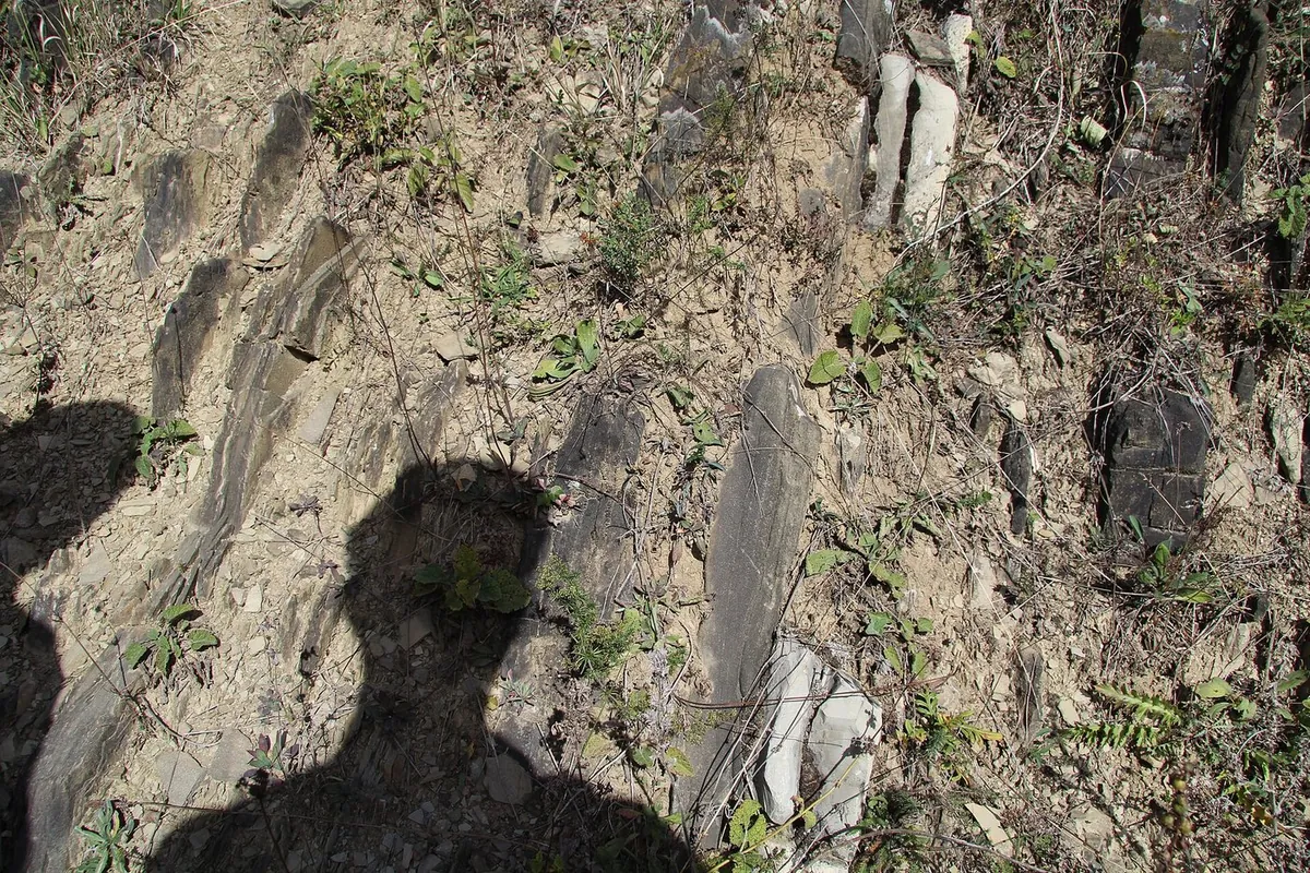
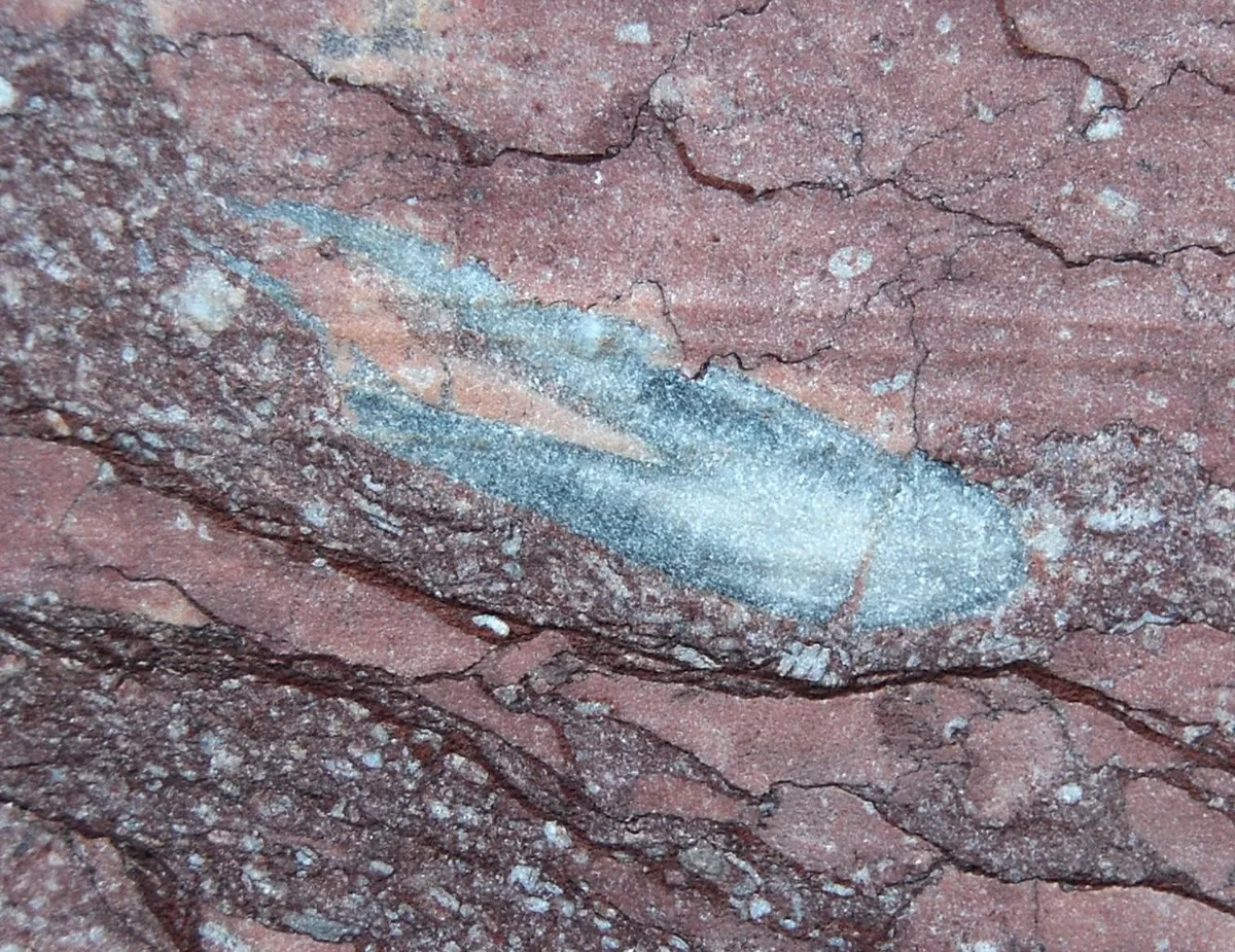
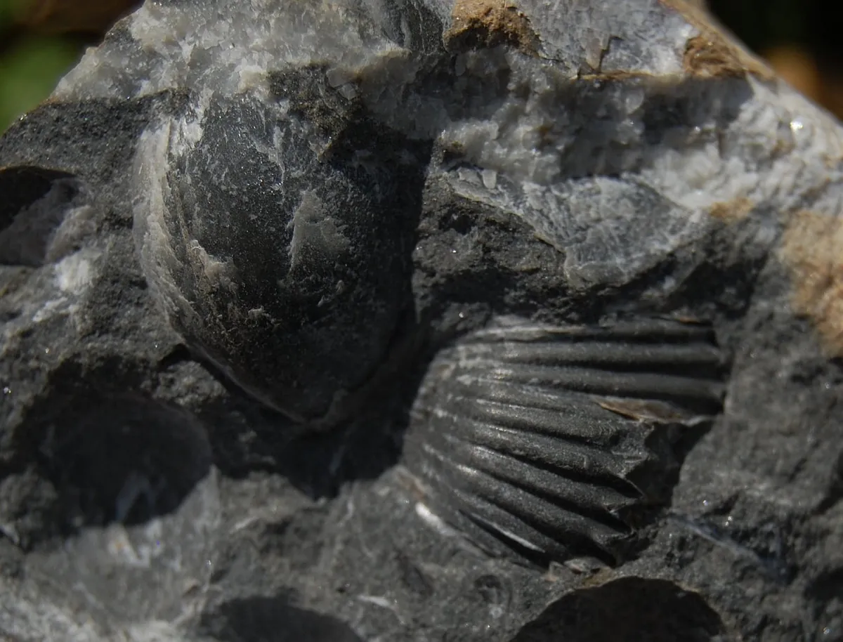
Flysch at Slătioara, Suceava County, in the Eastern Carpathians. The beds stand almost on end.GerritR, CC BY-SA 4.0, Wikimedia CommonsA belemnite, an extinct marine mollusc, from the Early Jurassic (as described with the photograph) at Moneasa, in the Codru-Moma Mountains (Apuseni).Tommy from Arad, CC BY 2.0, Wikimedia CommonsBrachiopods, marine animals, from the Middle Jurassic (as described with the photograph) in the Bucegi Mountains.Tommy from Arad, CC BY 2.0, Wikimedia Commons
Marine fossils in the mountains show that the rocks settled in the sea, not that the mountain stands on oceanic crust. The exact sentence: the flysch rocks were deep-sea sediment, two thin slices were oceanic crust, and the rest of the Carpathians is old continental crust or young volcanoes.
The globe shows more than we know. This is where it stops.
The ground, not the town. Models move pieces of crust. Your town is recent, and the dot on the globe is the centre of today's settlement, from GeoNames.
Longitude is the weakest. Palaeomagnetism gives latitude, not longitude, and there is no well-established method for absolute longitude before the Jurassic (Merdith et al. 2021). The Müller model takes it from hotspot tracks, most robust for the last 80 million years or so (Tetley et al. 2019). Beyond that age the east–west position on the globe is its weakest part.
The blocks are approximate. The three models draw the limits between Moesia, Tisza and Dacia differently, and in the Müller model the Alps and Carpathians also have zones that deform. A town near a boundary can jump from one block to another.
The sea on the globe is an interpreted map. The PALEOMAP relief and depth have 1° cells, about 110 km, and are geologists' interpretation, not a measurement. One cell can hold both coast and open sea.
The drawn coast is not the coast of the time. In the Müller and Merdith models the outline of the continents is today's, carried back with the plates. Sea level, mountains and gulfs of the time are missing. Only the PALEOMAP map shows them.
Each model gives, for every plate, a rotation relative to its own reference frame at intervals of 5 million years. The page splits Romania into the blocks each model has and rotates the place's point with its block's rotation, interpolating between two dates. Latitude, distances and shifts are computed from the rotated position. The results match the pygplates library to within 0.1 km when the rotation is read every million years.
The deforming zones of the Müller model were measured separately: 435 points across Romania were carried back through its deforming networks and compared with the rigid rotation of their block. The difference appears on the chart as a shaded band.
Müller, R. D., Zahirovic, S., Williams, S. E. et al. 2019. A global plate model including lithospheric deformation along major rifts and orogens since the Triassic. Tectonics 38. Data: EarthByte, licence CC BY-SA 4.0.
Merdith, A. S. et al. 2021. Extending full-plate tectonic models into deep time. Earth-Science Reviews 214: 103477 (read: the submitted version). Data: EarthByte, collection licence CC BY 4.0.
Scotese, C. R. 2016. PALEOMAP Global Plate Model and Scotese, C. R., Wright, N. 2018. PALEOMAP Paleodigital Elevation Models (PaleoDEMs) for the Phanerozoic. Data: the model and the relief on EarthByte, CC BY 4.0.
GeoNames, places in Romania, CC BY 4.0: 15,421 places with the coordinates of their centre.
Schmid, S. M. et al. 2008. The Alpine-Carpathian-Dinaridic orogenic system: correlation and evolution of tectonic units. Swiss Journal of Geosciences 101: 139–183. doi:10.1007/s00015-008-1247-3.
Ustaszewski, K. et al. 2008. A map-view restoration of the Alpine-Carpathian-Dinaridic system for the Early Miocene. Swiss Journal of Geosciences 101 (suppl. 1): S273–S294. doi:10.1007/s00015-008-1288-7.
Handy, M. R., Ustaszewski, K., Kissling, E. 2015. Reconstructing the Alps-Carpathians-Dinarides as a key to understanding switches in subduction polarity, slab gaps and surface motion. International Journal of Earth Sciences 104: 1–26. doi:10.1007/s00531-014-1060-3.
Márton, E. et al. 2007. The contact zone between the ALCAPA and Tisza-Dacia mega-tectonic units of Northern Romania in the light of new paleomagnetic data. Swiss Journal of Geosciences 100: 109–124. doi:10.1007/s00015-007-1205-5.
Gallhofer, D. et al. 2016. Magmatic and tectonic history of Jurassic ophiolites and associated granitoids from the South Apuseni Mountains (Romania). Swiss Journal of Geosciences 110: 699–719. doi:10.1007/s00015-016-0231-6.
Bracco Gartner, A. J. J. et al. 2020. Asthenosphere-induced melting of diverse source regions for East Carpathian post-collisional volcanism. Contributions to Mineralogy and Petrology 175: 54. doi:10.1007/s00410-020-01690-4.
Merten, S. et al. 2011. Toward understanding the post-collisional evolution of an orogen influenced by convergence at adjacent plate margins: Late Cretaceous-Tertiary thermotectonic history of the Apuseni Mountains. Tectonics 30: TC6008 (abstract only). doi:10.1029/2011TC002887.
Roban, R.-D. et al. 2020. Lower Cretaceous provenance and sedimentary deposition in the Eastern Carpathians: inferences for the tectonic evolution of the Ceahlău-Severin branch of the Alpine Tethys. Tectonics 39: e2019TC005780 (abstract only). doi:10.1029/2019TC005780.
Torsvik, T. H. et al. 2012. Phanerozoic polar wander, palaeogeography and dynamics. Earth-Science Reviews 114: 325–368. doi:10.1016/j.earscirev.2012.06.007.
Tetley, M. G. et al. 2019. Constraining absolute plate motions since the Triassic. Journal of Geophysical Research: Solid Earth 124: 7231–7258. doi:10.1029/2019JB017442.
Data licences
The data files on this page (plate rotations, the outline of the continents and of Romania cut into blocks) derive from the Müller et al. 2019 model and are made available under CC BY-SA 4.0. The model is published under CC BY-SA in its own instructions file and under CC BY in the licence file of its folder; the stricter condition is followed.
Files derived from PALEOMAP (rotations, outline, relief) and from the Merdith model are under CC BY 4.0; their EarthByte folders have no licence file of their own, so the collection's licence applies. GeoNames, CC BY 4.0. Natural Earth, public domain.