Călărași, Romania · The land, the town and the Borcea
A town buys
its own
ground.
250,000 lei opened the way to Călărași’s emancipation in 1852. But the waterfront remained disputed for another two decades. Follow the story on the town’s genuine plan.
1850
853 plots.
541 to start with.↗
Engineer Scarlat Popovici proposed 853 house plots. He recommended marking out just 541 at first: 188 in the red zone, 185 in blue and 168 in yellow. He feared the remaining markers would disappear before the town expanded.
Each mark = one proposed plot. This is a count diagram, without geographical positions.
Document 128 · p. 99 ↗1852
250,000 lei
to become free.↗
Călărași stood on land owned by Colțea Hospital in Bucharest. The act of 24 June 1852 confirms payment and declares the town and a surrounding tract of 1,714½ pogoane free. That September, Wallachia’s ruler, Barbu Știrbei, confirmed emancipation by charter.
Unsold plots were still to be sold for the hospital’s benefit.
Document 144 · p. 110 ↗15 VII 1852
The new town,
on a single sheet.↗
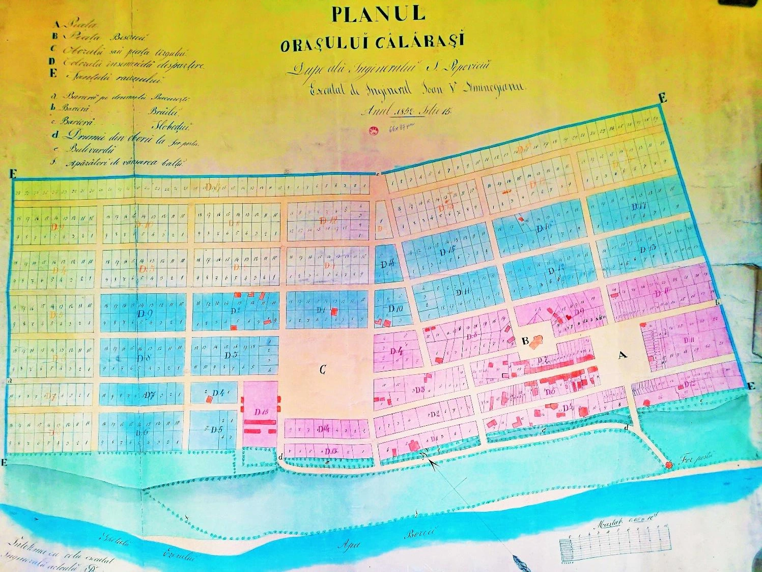
On 15 July, Ioan Siminogeanu drew this plan after Scarlat Popovici’s work. Colours divide the town; streets separate its blocks, and fine lines mark house plots. The 1850 proposal and this 1852 sheet are different documents.
A reproduction of the original document, not a current cadastral map.
Original plan · p. 418 ↗1852
The square and church
anchor the town.↗
A marks the square and B the old church. Their identities are stated in the sheet’s key. The surrounding blocks are divided into house plots, some with buildings drawn on them.
A · Square B · Old church
Original plan · p. 418 ↗1852 → 1875
The town was free.
The waterfront was disputed.↗
Emancipation did not settle every land dispute. The town and the hospital board went to court over land beside the Borcea and the Iezer channel. The town argued that its boundary reached the water; the board disputed that interpretation.
The Borcea follows the town’s edge on the drawing. The legal documents explain the dispute.
Document 184 · p. 143 ↗1875
The settlement
that reached the water.↗
The settlement signed on 1 February 1875 recognises the town’s ownership of the disputed ground down to the Borcea and the Gâtul Ezerului channel. The town drops its litigation claims; the board waives outstanding financial claims for the founding plots and retains free use of fishing sheds and the bridge connection. Carol I sanctioned the law on 28 February.
Excerpt from the act of 1 February 1875 · Published transcription, document 188
Document 188 · p. 147 ↗1976 / 1979
Building
the steel town.↗
The municipal history dates the start of steelworks construction to 1976 and the first steel to 1979. Călărași grew rapidly in the following decades. The map shows roads and buildings in the modern extract, rather than a reconstruction of the town in 1979.
Modern map · Approximate 1852 outline · 150 m caution band
Municipal history ↗1912 → 2021
The rise is visible.
So is the later decline.↗
Between the 1977 and 1992 censuses, the population rose by 27,225. The 1992 census counted 76,952 residents. In 2021 there were 58,211: a decline of 24.4%. These totals alone do not measure the steelworks’ impact.
Eight censuses · INS historical series and 2021 resident population
Census values and sources ↗Now explore for yourself
A sheet shows the planned town. The documents tell us what was paid and what was disputed. Today’s streets show where the town has continued to grow.
The document · A closer look
What is on
the 1852 sheet?↗
Choose a landmark on the sheet or a name in the list. The detail enlarges here, with an explanation from the original key.
How were the 853 proposed plots divided?
5 April 1850 · The earlier proposal
853 plots.
541 to begin with.↗
Popovici designed 853 plots but recommended marking out 541 first. He feared the other markers would disappear before the town grew.
A diagram of plot counts, without geographical positions. The report specifies 10 × 20 stânjeni per plot. A stânjen was a historical measure of length. The 1850 proposal and the final 1852 plan are different documents.
house plots proposed
Each mark represents one plot in the project reported in 1850. Choose a colour or the first phase to see the division.
Călărași today · Real geography
Find your street.
See the town beside the water.↗
Search for a street or choose directly on the map. See how it sits relative to the town planned in 1852 and how close it comes to the Borcea.

 Borcea
© OpenStreetMap contributors · ODbL · Street data
Today’s town
You can also choose a nearby road directly on the map. Search uses named streets in the local extract, rather than a complete postal address list.
1912–2021 · Eight censuses
The town grows.
Then loses residents.↗
The 1992 population is the largest among the censuses shown. By the 2021 census, the town had almost a quarter fewer residents.
residents in 1992
58,211 residents in 2021
−24.4%
Decline between the two censuses
INS, Romania’s national statistics office: stable population in the 1912–1992 series; resident population in 2021. These are census counts, not estimates for 2026.
View the census values and years
| Year | Residents |
|---|---|
| 1912 | 12,995 |
| 1930 | 18,053 |
| 1948 | 24,448 |
| 1956 | 25,555 |
| 1966 | 35,684 |
| 1977 | 49,727 |
| 1992 | 76,952 |
| 2021 | 58,211 |
The evidence and its limits
What we know.
And how we know it.↗
The documents, data and original image can each be checked. No present-day address is automatically equated with a nineteenth-century house plot.
- The emancipation documents
Călărașii în documente și izvoare istorice, volume I: report 128, pp. 99–100; act 144, pp. 110–111; charter 145, pp. 111–114; waterfront litigation and settlement, documents 184–189, pp. 143–148.
Open the source ↗ - The original 1852 plan
The same volume, appendix 20, p. 418. Explanatory points are read from the sheet’s key and positioned on the reproduction; they are not cadastral coordinates.
Open the source ↗ - The municipal history
Municipiul Călărași, scurt istoric, published by the town hall: the plan’s authors, its three colours and industrial development after 1976.
Open the source ↗ - The censuses
INS, table 3 of the 1992 census and table 1.22 of the 2021 census. Municipality of Călărași, SIRUTA code 92569.
Open the source ↗ - Today’s roads and buildings
OpenStreetMap database snapshot, 28 July 2026; extract downloaded 13 October 2026, © OpenStreetMap contributors, ODbL. Roads simplified for display; coverage may be incomplete. Romania outline: geoBoundaries, CC BY 4.0.
Open the source ↗ - The approximate 1852 outline
The municipal history names today’s Viitor, Portului and Gheorghe Lazăr streets as the limits. Fitting the outline uses those landmarks and separate checks; the 150 m visual margin keeps the placement uncertainty visible.
See the landmarks and measured errors ↗
How the comparisons work: 853 − 541 = 312 plots for later; 188 + 185 + 168 = 541; 76,952 − 58,211 = 18,741 residents, or 24.4% of the 1992 total. The plot diagram shows proposed counts, without geographical positions. The approximate planned-town outline is fitted to three boundary streets named in the municipal history. A withheld church-site check differs by 42 m; withholding an entire boundary route gives errors up to 147 m. The displayed 150 m caution band is a conservative visual allowance, not a statistical confidence interval. No address is matched to a historical parcel. The Borcea distance joins the mapped street’s nearest point to the mapped bank; it is not a walking distance.