
01/ 09The route
Between two seas
BEAT01 / 05
Two gulfsAn east–west linkThe map shows a connection, not distances.
Two gulfs
At the isthmus, the Saronic and Corinth gulfs sit on opposite sides of the cut. The Aegean opens to the east; the Ionian lies to the west.0112
The map shows a connection, not distances.
The sea route
Before the canal, ships round the Peloponnese by sea, past Cape Malea. Distance depends on the chosen ports; no one figure in miles or hours fits every route.0102
A sea route depends on its departure and arrival ports.
Isthmia
At Isthmia, the ship enters the eastern channel. The marker settles here; the drawing gives no local kilometre position.15
The ship’s position is schematic.
Through the cut
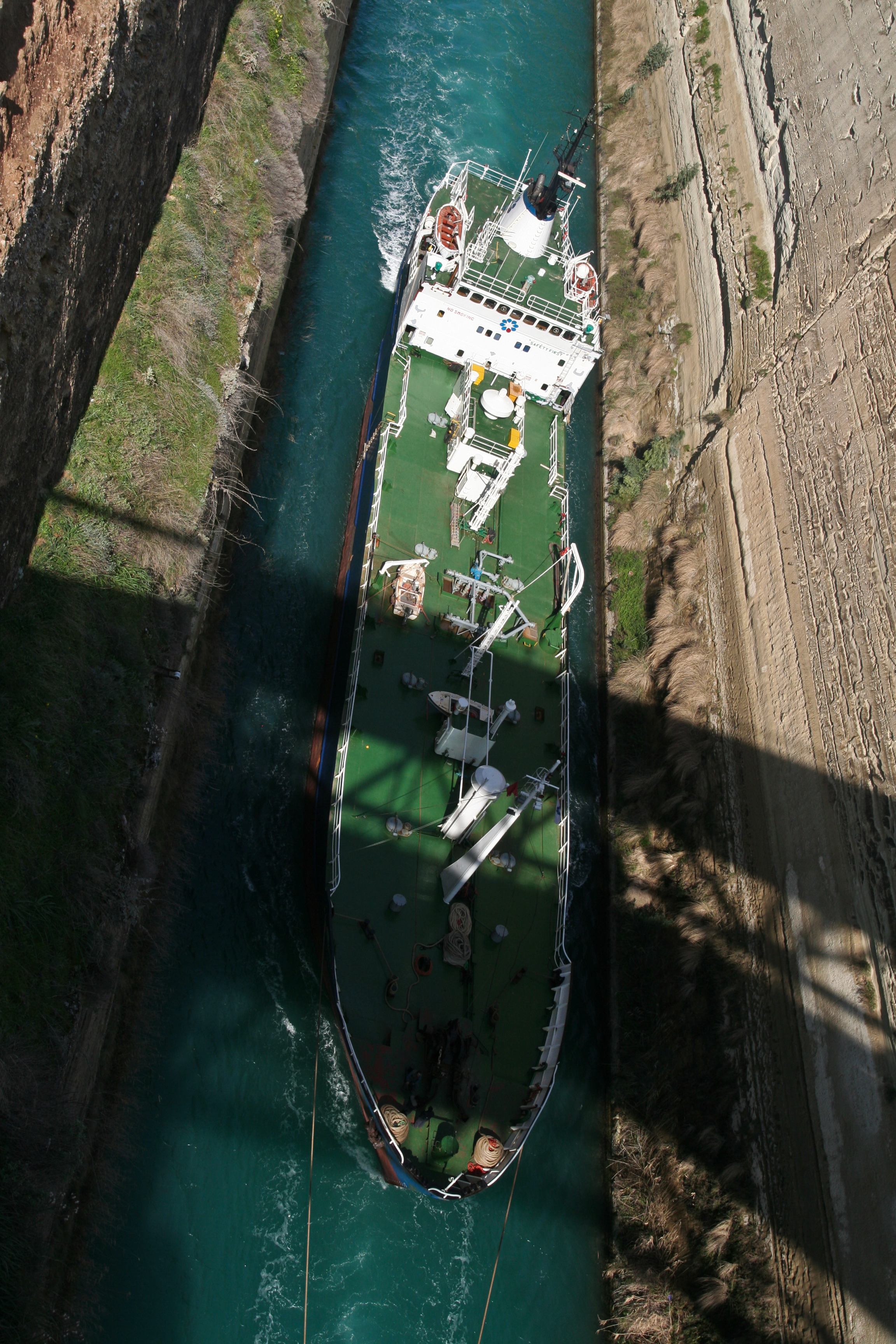
The operator lists 6,343 m for the full canal. The marker shows the cut scene, not a measured position in kilometres.13
Operator specification, not a kilometre reading at this point.
Posidonia
At Posidonia, the ship reaches the western end. Here, as at Isthmia, the road deck lowers below the water. Now watch the bridge at work.15
The operator describes a submersible bridge at each end.
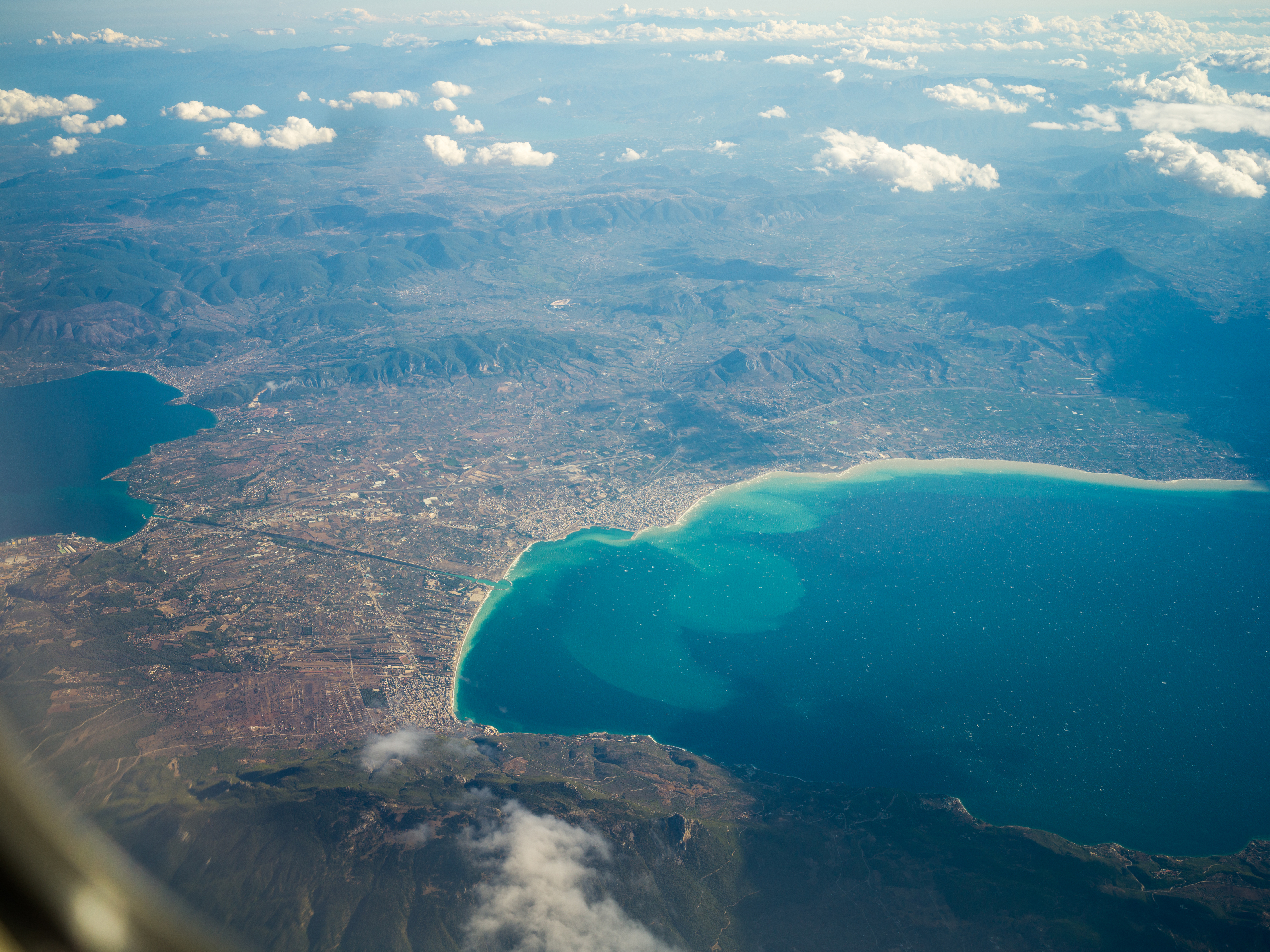
Image: Wolfgang Moroder · 29 June 2018 · CC BY-SA 3.0 · Wikimedia Commons
02/ 09The mechanism
The road goes under
BEAT01 / 05
The road stopsA submersible bridgeThe operator’s technical note describes submersible bridges.
The road stops
At Isthmia and Posidonia, the road descends vertically. The deck goes below the waterline; it does not rise over the canal.15
The operator’s technical note describes submersible bridges.
A ship approaches
The procedure starts about 15 minutes before a ship arrives, according to the operator.15
Approximate lead time from the operator’s procedure.
The deck descends
The deck lowers at about 4 metres per minute, according to the operator’s technical procedure.15
Approximate rate, not the full cycle duration.
The channel clears
A full lowering and refloating takes about three and a half minutes. That is not the ship’s total transit time.15
Approximate cycle time reported by the operator.
The road returns
After the ship passes, the deck returns to road level. The mechanism clears the channel without lifting the road above it.15
Schematic of the procedure, not a recording.
03/ 09The portage
The road that carried ships
BEAT01 / 06
OverlandThe DiolkosThe ancient accounts describe different uses and limits.
Overland
On the Diolkos, vessels cross the isthmus over land. Strabo describes a place where ships are hauled across; Pliny records a limit to the portage.0102
The ancient accounts describe different uses and limits.
Not every vessel
Ships too large for the portage sail around the Peloponnese. The shortcut serves some vessels, not every mariner.0102
Pliny records an exception, not a complete ship register.
The pavement
The surviving pavement measures about 3.6–4.2 metres across. The range describes documented remains, not every point along the route.030405
Approximate width of surviving paving.
Wheel marks
In the best-preserved stretch, the wheel grooves sit about 1.5 metres apart. They point to a route for wheeled carts.030405
Spacing comes from the best-preserved stretch only.
A probable date
The Greek Ministry of Culture places the road probably under Periander; Werner keeps open an earlier, simpler slipway. The Diolkos is a portage road, not a railway.0305
The date is not settled; an earlier slipway remains possible.
What remains unknown
The cradle that lifted a ship, the number of workers and crossing time remain reconstructions. The surviving pavement does not measure them.0305
The complete mechanism and logistics remain uncertain.
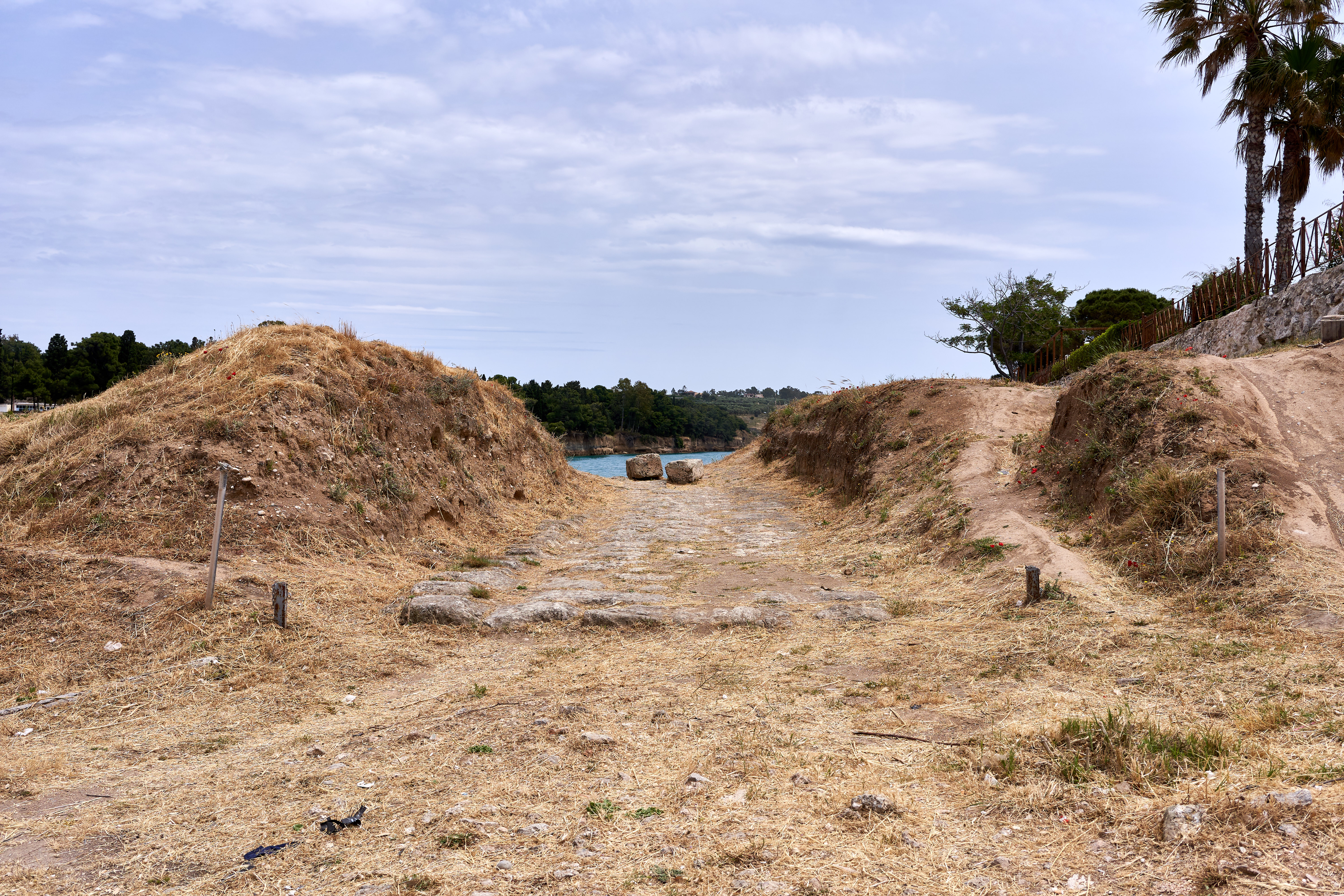
Image: George E. Koronaios · 22 May 2019 · CC0 · Wikimedia Commons
04/ 09Plans and doubts
The canal appears in texts
BEAT01 / 06
A plan attributedPerianderThe plan and oracle story come from different layers of tradition.
A plan attributed
In Diogenes Laertius’s account, Periander proposes a cut through the isthmus. The text does not say he builds the Diolkos; the oracle story comes from a later tradition.0605
The plan and oracle story come from different layers of tradition.
A mistaken calculation
Strabo passes on the claim that the Gulf of Corinth stood higher and a cut would flood Aegina. It is an ancient report, not a modern hydrological measurement.07
Strabo records the claim as a mistaken calculation.
Proposal and survey
Suetonius lists the canal among Julius Caesar’s proposed projects. For Caligula, he says a centurion was sent to survey the site.08
These are reports of initiatives, not excavations begun.
Nero starts digging
Around 67 CE, Nero begins excavation. Suetonius describes the trumpet and first basket of earth; a golden mattock appears in a literary dialogue of uncertain authorship, not as an archaeological object.0810
Suetonius and the literary dialogue are separate sources.
A disputed distance
Cassius Dio keeps a separate account; the sources disagree on how far the excavation advances. Josephus reports that Nero sends 6,000 young Jewish captives.082309
The 6,000 are Josephus’ reported contingent, not a verified workforce total.
No single reason for stopping
Work stops amid revolt and the regime change after Nero’s death. The sources give no single cause. In 1881, Gerster surveys traces attributed to the excavation. Next, follow his plan.05
The cited synthesis does not settle why work stopped.
05/ 09Traces and erasure
A plan preserves the traces
BEAT01 / 05
A view before the cut1881This account rests on Gerster’s plan, not remains visible today.
A view before the cut
In 1881, engineer Béla Gerster surveys cuttings attributed to Nero, before the modern canal. His plan remains the pre-construction record.1105
This account rests on Gerster’s plan, not remains visible today.
Two directions
Werner’s synthesis reads about 2 km of excavation to the west and 1.3 km to the east in the plan.1105
Approximate lengths read from a plan made before construction.
The test trench
The plan also shows an exploratory trench of about 400 metres and prospecting shafts.1105
A plan measurement, not one continuous trench preserved today.
A plan is not a wall
The measurements come from Gerster’s pre-construction plan. They are not Roman walls measured today.1105
An archived plan, not a present-day archaeological measurement.
The same corridor
The modern canal follows the same corridor and removes most old excavation surfaces. The drawing does not show one continuous trench visible now; work starts on a different scale in 1882. Follow the construction record.110512
The modern route changes what can still be seen.
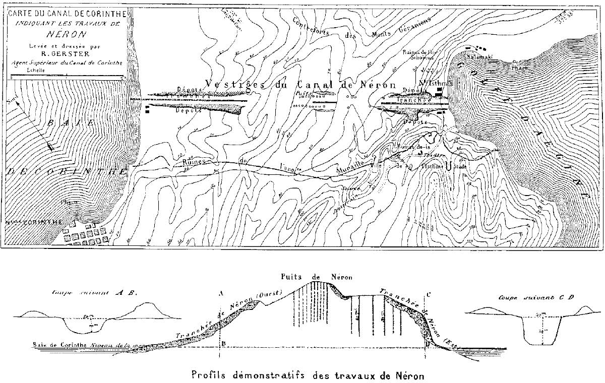
Image: Bela Gerster · 1881 · Public domain · Wikimedia Commons
06/ 09Construction to opening
Two companies finish the cut
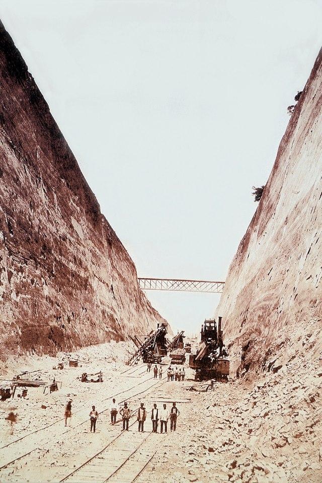
Image: Unknown author · circa 1890 · Public domain · Wikimedia Commons
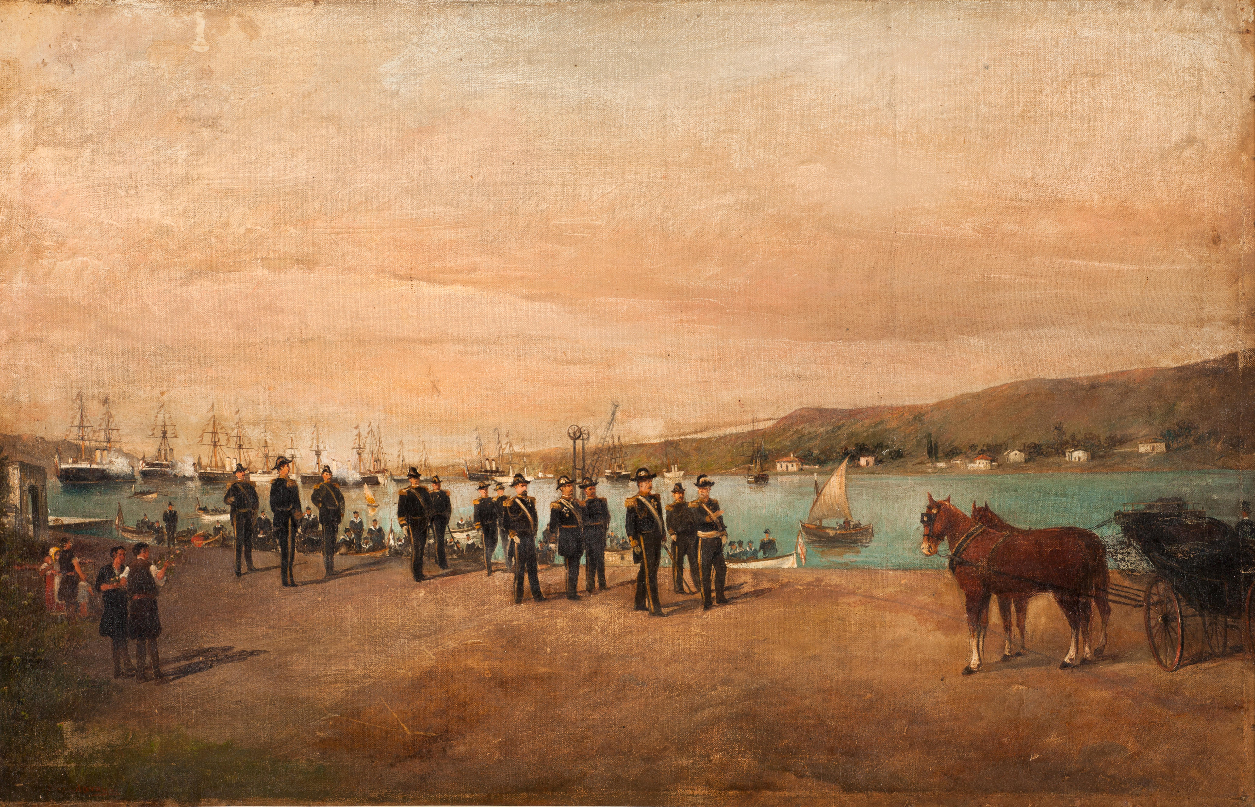
Image: Konstantinos Volanakis · circa 1893 · Public domain · Wikimedia Commons
BEAT01 / 06
Permission to dig1869 · 1881Separate legal milestones, not construction dates.
Permission to dig
The concession law comes in 1869; a state concession follows in 1881. These dates prepare the project, not the start of excavation.12
Separate legal milestones, not construction dates.
The cut begins
Work begins on 23 April 1882. The International Company of the Corinth Maritime Canal works with French-backed capital.1216
The operator dates construction and names the company.
The money runs out
In 1890, funds run out. A Greek company under Andreas Syngros takes up and finishes the work.1216
The operator’s history describes the company handover.
A fleet at the opening
The operator dates the formal inauguration to 25 July 1893. In Konstantinos Volanakis’s painting, officials and a fleet fill the scene.1217
The painting depicts the inauguration; the operator supplies the date.
General navigation
A reference published in 1911 says general navigation began in November 1893. Inauguration and navigation are two different records.1217
The navigation date comes from a 1911 reference.
First commercial transit
Without a primary 1893 register, the first commercial transit date remains unresolved. The Diolkos, Nero’s plan and the modern canal are separate projects.0512
We do not infer first transit from the inauguration date.
07/ 09Thresholds
A ship must fit several measures
BEAT01 / 06
Navigation width24.6 metres at sea levelOperator specification recorded in this edition on 6 October 2026.
Navigation width
At the waterline, the operator measures the navigable width at 24.6 metres. It is neither the bottom width nor the width permitted for a vessel.13
Operator specification recorded in this edition on 6 October 2026.
The bottom
The canal bottom measures 21 metres in the operator’s specification. Bottom width describes a different line in the section.13
Specification value; the drawing is not to scale.
Depth at the axis
The axis is 8 metres deep from mean low water. The water-level reference is part of the measurement.13
This is not a depth measured at every point along the canal.
Vessel beam
The regulation caps vessel beam at 18.3 metres. That limit belongs to the ship, not the canal opening; many large ships exceed it.1413
Navigation rule, not a channel measurement.
Walls above the water
At its highest point, the land reaches 79 metres above the sea. Maximum relief does not describe a uniform cliff height along the canal.13
A local maximum, not a constant wall height.
Current and rock
The regulations account for adverse currents, but the specification gives no measured speed. The steep slopes can fail.1314
No published current speed; slope failure is a separate risk.
08/ 09Reported traffic
Who passes, in the operator’s figures
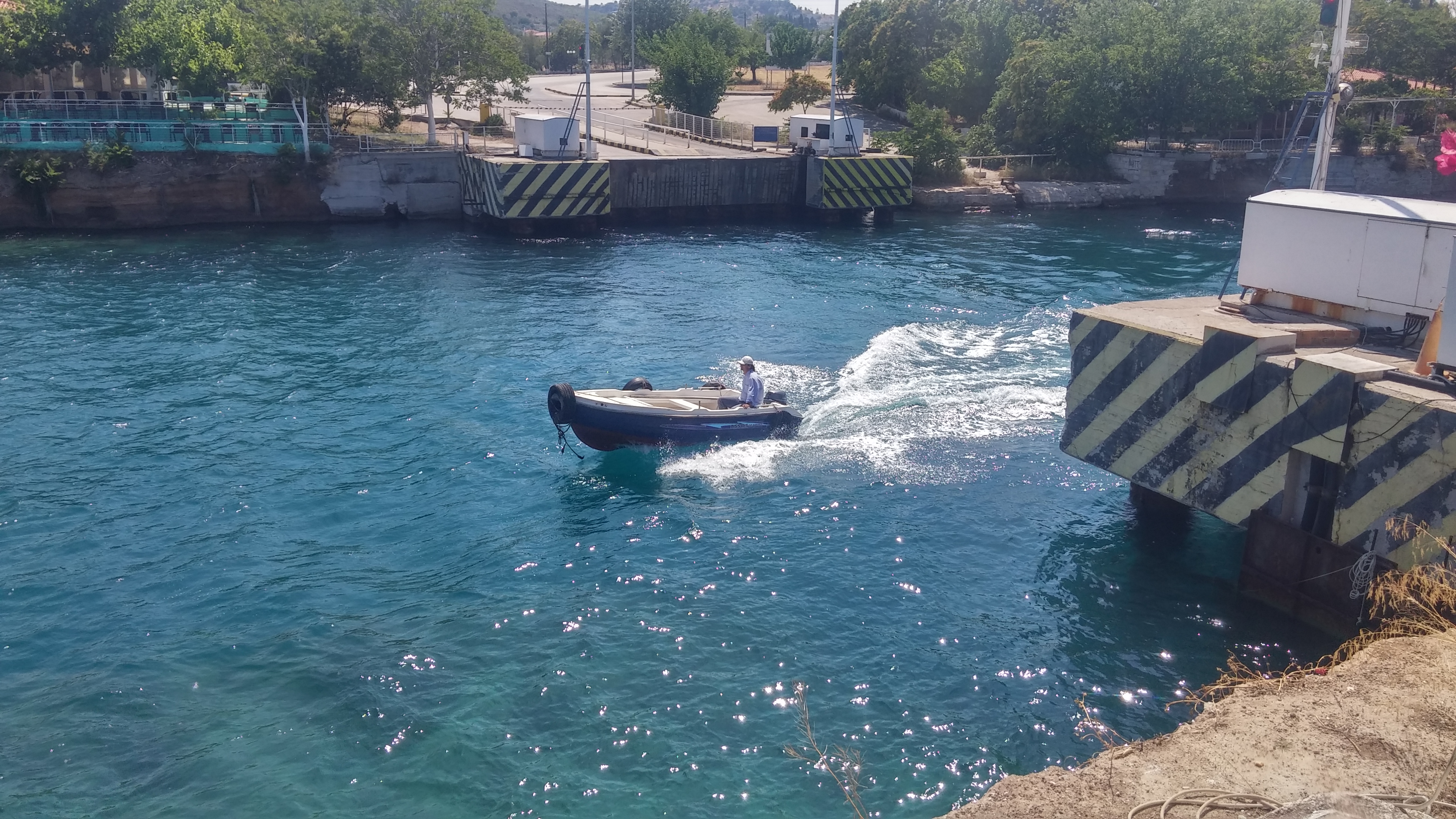
Image: Gregor Hagedorn · 6 June 2017 · CC BY-SA 4.0 · Wikimedia Commons
BEAT01 / 03
An annual benchmark2024 · about 11,500 passagesPublished operator benchmark, not an independently assured register.
An annual benchmark
In its 2024 report, the operator records about 11,500 passages for the year. The report is not independently assured.16
Published operator benchmark, not an independently assured register.
The reported mix
The 2024 report splits traffic into 78% tourism and 22% commercial. Category totals do not match across all operator pages.16
Published shares; categories are not reconciled across every page.
Passage has conditions
The shortcut opens to ships that fit, can navigate the current they meet and find the slopes clear. What happens when those slopes fail?131416
The published mix does not show how many ships were refused.
09/ 09Interruption and return
Rock interrupts the story
BEAT01 / 06
The 1923 fall41,000 m³ · two yearsRetrospective figures published by the operator.
The 1923 fall
In 1923, a collapse stops the canal. The operator’s retrospective attributes about 41,000 m³ of material and two years out of service to it.12
Retrospective figures published by the operator.
The 1944–1949 blockage
The operator links the 1944–1949 blockage to German explosions, about 60,000 m³ of debris and railway wagons dumped in the canal.12
Retrospective operator figure; the reported period stays intact.
The January notice
The operator announces a closure after the 15 January landslide. The notice is dated 18 January; the slide date and announcement date stay separate.1822
Two dates in one notice, not a timeline of every landslide.
A summer window
Navigation reopens for a summer window in 2022 and stops again in October.12202122
Dated notices describe a seasonal reopening, not a permanent one.
Seasonal works
Work continues through seasonal windows in 2023–2025. Each calendar and notice stays with its own dated document.192022
Successive schedules are not merged into one closure date.
Traffic resumes
The operator says traffic resumes after the main stabilisation phase. The date does not certify that every work package is complete or describe navigation on the day you read.12202122
A dated reopening notice, not a claim about complete works or current traffic.
10 / 10
Sources and notes
Ancient accounts, excavations and operator data describe different things. Each claim stays beside the source that supports it.
- S01 · ancient textStrabo, Geography 8.6.20
- S02 · ancient textPliny, Natural History 4.10
- S03 · archaeologyGreek Ministry of Culture: Diolkos brochure
- S04 · archaeologyVerdelis, Excavations of the Diolkos, 1957
- S05 · archaeology synthesisWerner, The Historic Diolkos of Corinth, 1997
- S06 · ancient textDiogenes Laertius 1.99
- S07 · ancient textStrabo 1.3.11
- S08 · ancient textSuetonius, Lives of the Twelve Caesars
- S09 · ancient textJosephus, Jewish War 3.540
- S10 · later literary dialogueNero, On the Digging of the Isthmus
- S11 · historical surveyGerster, L’Isthme de Corinthe, 1884
- S12 · operator historyCanal history — Corinth Canal S.A.
- S13 · operator specificationsTechnical specifications — Corinth Canal S.A.
- S14 · operator rulesNavigation regulations — Corinth Canal S.A.
- S15 · operator servicesTechnical services — Corinth Canal S.A.
- S16 · operator report2024 Sustainability Report — Corinth Canal S.A.
- S17 · contemporary referenceEncyclopaedia Britannica 1911, “Corinth”
- S18 · operator noticeCorinth Canal S.A., transit suspension notice, 18 January 2021
- S19 · operator noticeCorinth Canal S.A., 2023 reopening schedule
- S20 · operator noticeOperator reopening notice, 17 June 2026
- S21 · reportingGTP Headlines, June 2026 reopening
- S22 · reportingGTP Headlines, 2026 restoration works
- S23 · ancient textCassius Dio, Roman History, Book 62