The map could not load. The text below holds every result.
Geography · interactive map
Where is the centre of Europe?
At least eight places, from an Estonian island to the Carpathians, say they are the centre of Europe. Recalculated with the method France’s national mapping agency (IGN) uses for the EU’s centre, the answer stays in one area, near only one of the claimants: across 768 ways of drawing the debatable borders (the Urals, the Caucasus, Iceland, Cyprus), every centre lands within 290 km of the others, in Lithuania or Belarus.
The map holds a pin at Europe’s balance point. Tap a country to drop it from Europe or put it back; tap an obelisk for the monument’s story.
Where do the usual borders put the centre of Europe?#
A boundary of Europe used in many atlases follows the crest of the Urals, the Ural River, the Caspian, the crest of the Caucasus, the Black Sea, the Bosporus and the Dardanelles (below, “the convention”). With Iceland and the Arctic islands (Svalbard, Novaya Zemlya, Franz Josef Land), that Europe covers 10.21 million km². Its balance point falls 11 km north-west of Švenčionėliai, Lithuania, at 55.24° N, 25.92° E, 33 km from the Belarusian border.
The balance point is where a map of Europe cut from card of even thickness would rest on the tip of a pin. The calculation uses the Earth’s real shape: it adds up the position in space of every square of land about 2 km across, and their average lies 189 km beneath Lithuania. Raised straight up to the surface, that point is the centre. France’s national mapping agency (IGN), which computed the EU’s centres, uses the same method and wrote in 2007 that the European point lies “180 kilometres below the ellipsoid”.
How much do the islands matter?#
Iceland pulls the centre west: without it, the pin moves 27 km south-east. Without the Arctic islands it moves 41 km south. Madeira, the Canaries and Cyprus, usually counted outside geographical Europe, and the Azores, sometimes counted in it, add up to about 20,000 km² and move it by 3 km at most each.
Where does Europe end in the east and south-east?#
Another convention runs the border along the Kuma–Manych depression, north of the Caucasus. Russia’s North Caucasus (272,000 km²) then leaves Europe and the centre moves 47 km north-west. If, instead, Georgia, Armenia and Azerbaijan come in whole, it moves 39 km south-east.
In the east, some geographers take the border down the Emba instead of the Ural River, which adds 214,000 km² of Kazakh and Russian steppe and moves the centre 42 km east. Turkey matters most: with all of Anatolia, the pin travels 135 km south-east.
Can the centre be moved out of Lithuania and Belarus?#
Combine every one of these choices (the Ural or the Emba, three Caucasus borders, European Turkey or all of it, each island group in or out) and you get 768 different Europes. The red dots on the map are their centres. All of them fit inside a 290 km patch, and all fall in Lithuania or Belarus.
A few choices on their own push the centre across into Belarus: all of Turkey, the Caucasus countries whole, or Europe without both Iceland and the Arctic islands. None of the combinations takes it out of those two countries; only dropping whole countries from Europe (see below) can send it elsewhere.
Why isn’t the Lithuanian monument exactly at the centre?#
The monument at Purnuškės, north of Vilnius, marks the point the IGN engineer Jean-Georges Affholder computed in the late 1980s, with the same method as here. The usual borders on the map put the centre 54 km from it. IGN wrote only “from the Atlantic to the Urals and the Caucasus”; which islands it counted appears in no document found. Of the 768 definitions on the map, 24 give a centre within 25 km of it.
What did Belarus compute?#
Around 2000, two Belarusian surveyors computed a centre by Lake Sho, counting the Baltic and White Seas as part of Europe. Redone that way, the calculation lands 142–156 km from their point. The 2008 monument in Polotsk carries the town’s own coordinates, 47 km from the computed point.
What happens if you average the degrees?#
The simplest calculation averages latitudes and longitudes on a flat map. It is wrong: a degree of longitude is 111 km at the Equator and only 36 km at Cape Nordkinn, so the far north and east, where degrees are narrow, weigh too much. Averaging degrees moves the convention’s centre 212 km east, near Rossony, Belarus; the blue dots show where it lands for all 768 Europes.
The second shortcut takes only the extreme points and averages them. With the capes listed on Wikipedia, the result falls on the Estonian island of Saaremaa, 1.7 km from the stake at Mõnnuste, whose point the parish’s development plan says came from Wikipedia. And the latitude of Suchowola, in Poland, lies within a kilometre of halfway between the continent’s northern and southern capes.
And the monuments in the Carpathians?#
Three places in the Carpathians claim the centre of Europe: Dilove in Ukraine, Kremnické Bane in Slovakia and Tállya in Hungary. None of the 768 definitions brings the centre of area within 646 km of any of them.
The stone at Dilove, on the Tisa, 6.3 km from the Romanian border, is an 1887 levelling benchmark: a fixed height for Austro-Hungarian surveyors. Its sister, set the same year, stands in the Turnu Roșu Pass near Sibiu in Romania, and nobody calls that one the centre of Europe.
Where is the centre of the European Union, and why is it near Würzburg?#
IGN has computed the EU’s centres with the same algorithm. The same method applied to the same territories reproduces the points attributed to IGN from 1995 to 2020 to within 2–11 km. Since 1995 IGN has also counted the outermost regions: French Guiana, Réunion, Guadeloupe, Martinique, the Canaries, Madeira and the Azores, and from 2014 Mayotte.
French Guiana, in South America, is only 2.0% of the EU’s area, but it is 7,800 km away. Without it, the centre would sit 123 km further east. Without any overseas region it would land near Grafengehaig in northern Bavaria, 131 km from Gadheim, where a post with a flag was set up in a field outside Würzburg. IGN itself wrote that, because of Guiana, the centre including the overseas regions lies “more than 100 kilometres” south-west of the one without them.
The EU centre after each enlargement
| Year | Members | Point attributed to IGN | Calculation here, distance |
|---|---|---|---|
| 1986 | 12 | Saint-André-le-Coq | 10.3 km |
| 1990 | 12 | Saint-Clément | 29.0 km |
| 1995 | 15 | Viroinval | 10.8 km |
| 2004 | 25 | Kleinmaischeid | 2.5 km |
| 2007 | 27 | Meerholz | 2.4 km |
| 2013 | 28 | Westerngrund | 3.0 km |
| 2020 | 27 | Gadheim | 3.2 km |
The 2004 and 2007 points come from IGN documents; the others from Affholder’s figures quoted by J. S. Krogh (1995), the press and Wikipedia, which attribute them to IGN (for 2013 the announcement came from Bavaria’s finance ministry). For 1986 and 1990 only the village names are known, so the distance is measured to the village centre. The 1958, 1973 and 1981 centres appear only on an IGN map, without coordinates.
How far did Brexit move the centre of the EU?#
When the United Kingdom left on 31 January 2020, the EU’s centre moved 56 km south-east, from Westerngrund to Gadheim (the two published points are 56 km apart). In 2007, with Romania and Bulgaria, it had jumped 118 km east.
The eight places that say they are the centre of Europe#
Distances are measured from the convention’s centre on the map (55.24° N, 25.92° E).
Purnuškės, Lithuania
Computed in the late 1980s by France’s national mapping agency (IGN); 1989 according to the Lithuanian encyclopaedia. A stone from 1997, the monument from 2004, 25 km north of Vilnius.
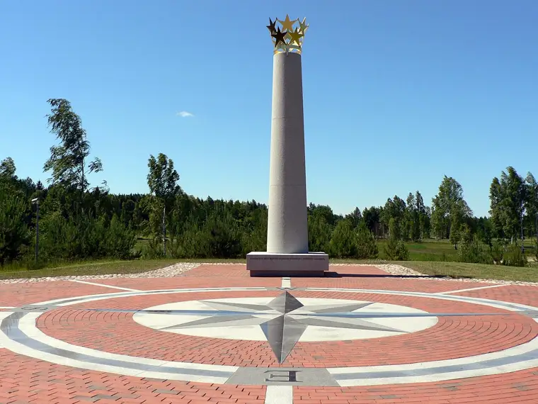
Purnuškės, Lithuania. Photo: Wojsyl, Wikimedia Commons, CC BY-SA 3.0 A white granite column crowned with stars, on a wind rose. The IGN engineer Jean-Georges Affholder computed the point with the same method as the map here: the centre of gravity of the area, on the ellipsoid. Affholder’s figures, as quoted by J. S. Krogh, are given only to the minute of arc (54°54′ N, 25°19′ E), so to about a kilometre; the monument stands 0.8 km from that rounded point. Which islands IGN counted is not written in any IGN document found so far.
Same method. The usual borders on the map put the centre 54 km from the monument. Of the 768 definitions, 24 land within 25 km of it, the closest at 9 km. The gap probably comes from which islands were included and the exact line of the borders, which IGN did not detail.
Lake Sho, Belarus
Computed in 2000 or 2002 (sources differ) by Alexey Solomonov and Valery Anoshko, with Belaerokosmogeodeziya.
The computed point lies among lakes Sho, Ives, Dolgoe and Psuya, 47 km south-west of the Polotsk monument. The method described: Europe “taken as a whole”, with the Baltic and White Seas, Great Britain, Ireland and Novaya Zemlya, and only the largest islands.
Redone with the stated method (seas included, large islands only), the calculation lands 142–156 km from the point. No definition on the map comes closer than 72 km. A plain average of the degrees of latitude and longitude (see below) lands within 25 km of it for 18 of the definitions, though no source names that as their method.
Polotsk, Belarus
Monument unveiled on 31 May 2008, City Day.
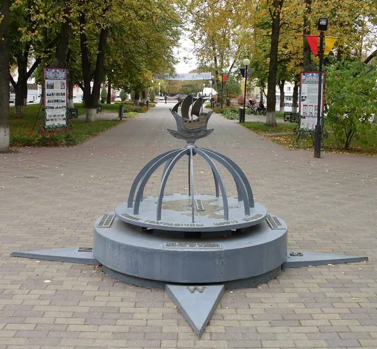
Polotsk, Belarus. Photo: Tranzit-by, Wikimedia Commons, CC BY-SA 3.0 A globe of the Northern Hemisphere carrying the ship from the town’s arms. The coordinates on it, 55°30′ N, 28°48′ E, are those of Polotsk itself; the point the Belarusian surveyors computed is 47 km south-west, by Lake Sho.
It is 183 km from the convention’s centre.
Suchowola, Poland
Attributed to the royal astronomer Szymon Antoni Sobiekrajski, 1775. A boulder inscribed “Środek Europy”.
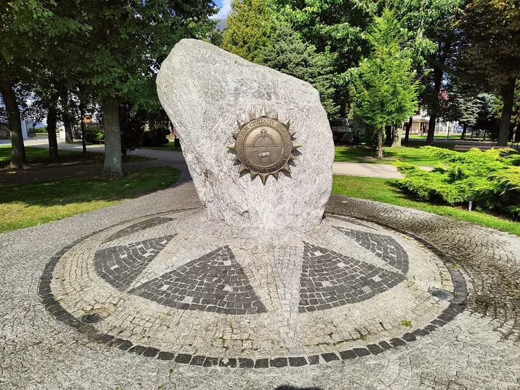
Suchowola, Poland. Photo: Zala, Wikimedia Commons, CC BY-SA 4.0 Polish Wikipedia says the point is where “the lines joining Europe’s extreme points cross”. No 1775 document has been found, nor the list of extreme points used.
The latitude fits: halfway between Cape Nordkinn (Norway) and Punta de Tarifa (Spain) is 53.57° N, 0.9 km from Suchowola. The longitude would fit only with an eastern edge at 55.7° E, far short of the Urals (66° E). From the convention’s centre: 260 km.
Mõnnuste, Saaremaa, Estonia
Set in 2008 by the development committee of Kärla parish. Marked with a juniper stake.
According to the daily Eesti Päevaleht (2009), the point was found “according to the internet encyclopaedia Wikipedia”, counting the continent’s extreme points including islands. A survey firm staked it out.
It can be reproduced: the average of the latitudes and longitudes of the four capes on Wikipedia’s “Extreme points of Europe” page (Cape Fligely in Franz Josef Land, Gavdos off Crete, Bjargtangar in Iceland, Cape Flissingsky on Novaya Zemlya) lands 1.7 km from the stake. Had the west been the Azores, as the same island list says, the point would sit at 18.88° E instead of 22.25° E. This is an average of degrees; the centre of area is 407 km away.
Dilove, Ukraine
An Austro-Hungarian levelling benchmark from 1887, on the road between Sighet and Trebušany (today Dilove).
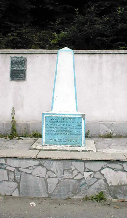
Dilove, Ukraine. Photo: Mws.richter - Stefan Richter, Wikimedia Commons, CC BY-SA 3.0 Josef Zeger’s history of Austrian levelling (1986) lists it among the seven main benchmarks of the Vienna Military Geographical Institute’s precision-levelling network, at 367.6820 m above the Adriatic. The levelling had been requested by the international arc-measurement programme, the “Europäische Gradmessung”. The Latin inscription, repainted with errors, says “Locus perennis” (permanent point) and mentions the levelling and the “European” measurement of degrees (its twin stone at Lišov, in Czechia, reads “which they call European”). It gives no coordinates and nowhere says “centre of Europe”. The Soviet plaque calls it a “point of the state geodetic network”. The “centre of Europe” stele came in 1977 or 1979 (sources differ).
None of the 768 definitions brings the centre within 646 km of Dilove; the convention’s centre is 819 km away.
Kremnické Bane, Slovakia
Claimed since 1815, according to Slovak Wikipedia, by the church of St John the Baptist. Author and method unknown.
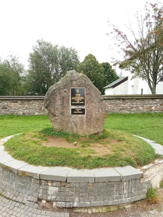
Kremnické Bane, Slovakia. Photo: Samosamuel 2602, Wikimedia Commons, CC BY-SA 4.0 The church stands on the divide between the Váh and the Hron, both in the Danube basin. English Wikipedia says, citing a plaque, that the method may have been “the centre of the smallest circle around Europe”.
That method does not hold: the smallest circle around the convention’s Europe is centred in Sweden, near Vikingstad, 1,104 km from Kremnické Bane. None of the 768 definitions brings the centre of area closer than 769 km.
Tállya, Hungary
“Measured by specialists in 1992”, says the village website. A wooden phoenix statue from 2000.
The village website says Europe’s “geometric centre” is here, without naming who measured it or how.
None of the 768 definitions brings the centre of area closer than 719 km; the convention’s centre is 844 km away.
Could the centre of Europe fall in your town?#
Type a place. The page searches, one choice at a time, which countries would have to leave Europe or come back and which borders would have to change for the pin to land there. It is one recipe found by trial, not the only one, but it shows how hard the map has to be pushed. London, for instance, is 1,771 km from the convention’s centre.
Your Europe#
Choose the borders yourself. Each change moves the pin; the distance from the convention’s centre appears on the map.
Method and sources#
Land comes from Natural Earth (1:10 million, the edition with the borders Ukraine recognises). The border with Asia: the Ural watershed from HydroBASINS (Lehner and Grill, 2013), then the Ural River to the Caspian. The Caucasus crest is drawn along Russia’s border with Georgia and Azerbaijan, which follows it for most of its length; the Kuma–Manych line and the link through the Mugodzhar hills to the Emba are drawn by hand. Moving these lines by 20 km shifts the centre by at most 2.2 km.
Each 0.02° square of land gets its position in space on the WGS84 ellipsoid and its true area. The weighted average is the centre of gravity; the point on the surface above it is the centre. On a grid twice as fine, the centre moves 63 metres. Computed another way, as a flat centre on an equal-area map centred on it, it differs by 2.5 km. That is why coordinates are given to hundredths of a degree.
Places come from GeoNames. The EU centres for 2004 and 2007 are from IGN’s releases; the others from the press and Wikipedia, citing IGN.
Sources
- IGN Magazine no. 40 (2007), “Union européenne : les justes milieux”
- IGN press release, April 2004: the centre of the EU of 25
- J. S. Krogh, Geosite: J.-G. Affholder’s (IGN) coordinates
- J. Zeger (1986), “Historische Entwicklung des Präzisionsnivellements in Österreich”, ÖZfVuPh 74(4)
- French Wikipedia: Centre de l’Europe (EU centres)
- Eesti Päevaleht (2009), on the Mõnnuste point
- English Wikipedia: Extreme points of Europe
- Vedaj.by: the geographic centre of Europe in Belarus
- Cyclowiki: Polotsk, geographic centre of Europe
- Myfin.by: Lake Sho
- Polish Wikipedia: Suchowola
- Slovak Wikipedia: Stred Európy
- Tállya village website (2008)
- Carpathian Biosphere Reserve: geographical centre of Europe (Dilove)
- Universal Lithuanian Encyclopaedia (VLE)
- Natural Earth, 1:10 million data
- HydroBASINS (Lehner and Grill, 2013)
- GeoNames places (CC BY 4.0)