A map of Chișinău, from 1887 to today
Chișinău, layer by layer: from the 1887 plan to today’s city
Tap the map anywhere to see, for that spot, whether it was town in 1887, how high the ground is, when it was built on, how many trees surround it and how far the trolleybus is.
The ground
A city on hills, with the Bâc down in the valley#
Chișinău is not flat. Within the city limits the ground rises from 31 m above sea level beside the Bâc to 211 m on the hills, a difference of about 180 m (1% of the area lies below the first figure, 1% above the second).
The Bâc, a tributary of the Dniester, crosses the city from north-west to south-east. City Hall describes a stretch of about 2 km, between Feredeului and Petru Rareș streets, where its bed is lined with concrete.
The shading is computed from the Copernicus terrain model, smoothed so that it no longer shows roofs and tree crowns.
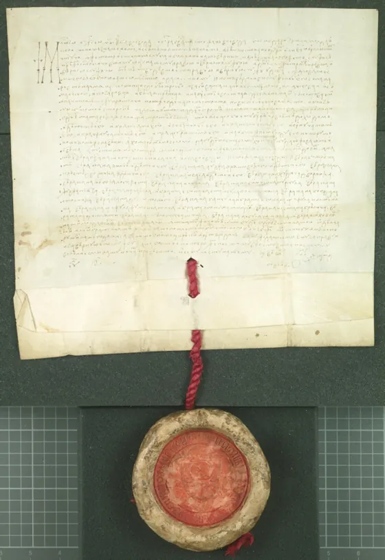
17 July 1436
The name in 1436: “Cheșenăul lui Acbaș”#
A charter issued at Vaslui on 17 July 1436 by Ilie and Ștefan, joint rulers of Moldavia, confirms several estates to the chancellor Oancea. Among the places it names is “Cheșenăul lui Acbaș”, usually taken as the oldest known record of the city’s name.
The document does not say how large the place was or exactly where it stood. The market town then grew on the bank of the Bâc, in the lower part of today’s city, with crooked lanes that still show on the map around Măzărache hill.
1817–1887
A town drawn with a ruler, on the 1887 plan#
In 1817 the land surveyor Mihail Ozmidov presented a plan for the new part of the town, which the Russian Empire had annexed with this eastern half of Moldavia, Bessarabia, in 1812. After years of revisions the extension plan was confirmed on 9 August 1834. The main street, now Ștefan cel Mare și Sfânt Boulevard, was laid out 20 stânjeni wide (about 43 m).
The plan lithographed in 1887 shows both towns: on the right, the old market town by the Bâc; on the left, the new town with straight streets. A handwritten note on the sheet calls it an annex to the report on paving the city’s streets with granite in 1888; the thick lines probably mark the streets paved that year.
The plan is fitted to today’s streets and to four buildings that stand on both (the cathedral, St George’s and Ciuflea churches, the station). Away from the grid it can be off by a few tens of metres.
The measurement
Three quarters of the street length in the 1887 town runs on the same two directions#
Over the town drawn in 1887 (about 6 km²), today’s streets have two dominant, perpendicular directions: 47° and 137° from north. 74% of their length runs on one of them, within five degrees. A street network with random directions would give about 11%.
In the rest of the city the share falls to 20%. It is highest in Botanica (30%), where Dacia Boulevard and the streets around it run parallel to the centre’s streets, and lowest in Rîșcani (12%).
1897
Who lived in the town on the plan#
The Russian Empire’s census of 1897 counted 108,483 people in Chișinău and asked for each person’s native language (it did not ask about ethnicity). 49,829 gave Yiddish, nearly half the town; 29,299 Russian; 19,081 Moldovan or Romanian; 3,393 Ukrainian; 3,247 Polish.
Each square is 100 people, by the native language they gave in 1897.
1903 · 1941
The pogrom of 1903 and the ghetto of 1941#
The Jewish community lived through the pogrom of April 1903, in which, according to the Jewish Encyclopedia, 47 Jews were killed and 92 severely injured. In July 1941, after the city was occupied, Romanian and German units began systematic shootings of the Jewish residents; about 11,000 survivors were herded into a ghetto, and in October those left alive were deported to camps and ghettos in Transnistria (United States Holocaust Memorial Museum).
1959–1989
The city that tripled in 30 years#
Moldova was Soviet from 1940 to 1941 and again from 1944 to 1991. Between the censuses of 1959 and 1989 the city grew from 216,005 to 667,082 people. The estates of apartment blocks appeared then: in Botanica, for example, large-scale housing starts in 1960, according to the sector’s administration.
The European Commission’s Global Human Settlement Layer begins in 1975. The colour shows the first five-year step in which each patch of ground appears built up.
12 October 1949
The trolleybus wire#
The first six trolleybuses entered service on the main street on 12 October 1949, on a 6 km route, according to the Chișinău electric transport company (RTEC).
Today OpenStreetMap describes 32 trolleybus routes and 134 km of street with overhead wire (some routes to the surrounding towns run part of the way on battery, off the wire). 54% of the city’s built-up surface lies within 300 m of a wire; in Centru sector, 60%.
Trees
How green Chișinău is, measured the same way as 39 other capitals#
Chișinău has a reputation as a green city. On the European land-cover map for 2021 (ESA WorldCover, from Sentinel images), 39% of the land in the city’s built-up core is covered by trees.
Measured the same way, on the same kind of outline, across 40 European capitals, Chișinău comes 13th: below Berlin, Warsaw or Vilnius, about level with Belgrade, Prague and Budapest, far above Bucharest (25%). On another measure, the average greenness of the built-up area (Landsat), it comes 16th. Within sector limits, Rîșcani has the most trees (50%) and Ciocana the fewest (37%).
40 capitals
Trees in the built-up core of European capitals, 2021#
Chișinău, with 39% of its land under trees, comes 13th of 40. The same outline for every city: the GHSL urban centre, water excluded.
Land covered by trees in the built-up core, 2021. ESA WorldCover; GHSL UCDB R2024A.
After 1990
Fewer people, more built-up city#
The 2024 census counted 567,038 people in the city, 100,044 fewer than the census of 1989. The two do not count the same way: in 1989, the population present; in 2024, the people who had lived here for most of the past year.
Meanwhile the city’s built-up surface grew by a quarter between 1990 and 2020, and the municipality’s by half. The map shows only ground built on after 1990: two thirds of it lies outside the city proper, especially in Trușeni, Codru, Sîngera, Durlești and Bubuieci.
1897–2024
How many people each census counted in the city#
From 108,483 people in 1897 to 667,082 in 1989 and 567,038 in 2024, in the city proper. Each census counted by its own rules (population present, legal, permanent or usual residents).
People in the city at each census: 1897, 1930, 1959, 1970, 1979, 1989, 2004, 2024.
Under Cricova
Cricova, a town of the municipality, sits above more than 120 km of galleries#
Cricova, one of the towns within the municipality of Chișinău, sits above the galleries of a former limestone mine. In 1952 they became a sparkling-wine factory; today they extend for more than 120 km, according to Moldova’s entry on the UNESCO Tentative List.
The open map
Any point in Chișinău#
Tap or click anywhere on the map. For the chosen point you get the height of the ground, whether it lay in the town drawn in 1887, the direction of the nearest street, the first year the ground appears built up, the trees around it and the distance to the trolleybus wire.
Or choose a sector or a town:
Your position stays in this browser; a shared link rounds it to 100 m.
Marius Comper · 18 October 2026