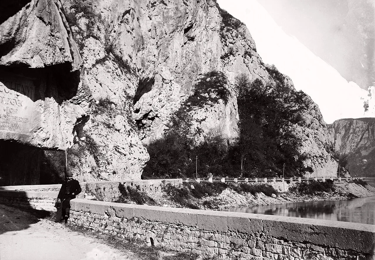
01 · 1837
Who cut the Széchenyi road?
The Cazane are the narrow Danube gorge between the Banat, in Romania, and Serbia. The road on the left bank, the northern side, carries the name of István Széchenyi. Work on it began in the spring of 1834 and caught a year of unusually low water, Daniel Guță writes in Adevărul on 26 September 2026. Rubicon, in the English translation of a text by Nánay Mihály, places the start of the regulation in 1833, with Pál Vásárhelyi as lead engineer and Széchenyi as commissioner. Those are two printed dates. Both stay.
"The rocky stretches that until now blocked the link between Moldova and Orșova, along the left bank of the Danube, have for the most part been cut through and, probably as early as next year, will be usable not only as towpaths, but also as carriage roads."
István Széchenyi, on 20 July 1834, in a letter printed by Daniel Guță. The English follows his Romanian text.
Past Moldova, the name the letter uses, the mountain came down into the river and had to be broken. The same article also calls the place Moldova Nouă. Moldova here is the town on this bank, not the country. By the end of 1834 the road had reached Plavișevița. The Cazane were cut in 1835.
"The rocky mountain had to be broken over a whole mile. Three thousand people worked on these cuttings. A huge effort was needed to win ground in the Cazane, because in many places the great rock masses came down almost vertically into the Danube."
Antal Boleszny, in the 1878 study, quoted by Guță. The mile stays his unit.
Boleszny also describes the road. Ground at the foot of the mountain was won by galleries and by blowing the rock with powder. A stone wall was raised on the river side.
"The road was protected against the river by a parapet and was about six metres wide."
Under Vásárhelyi, and with Széchenyi present, several thousand workers were brought in, masons among them. Temporary rooms for Széchenyi were built near Ponicova Cave, Peștera Ponicova.
"The Széchenyi road was opened to traffic in 1837. From that moment Berzasca, Svinița, Tisovița, Eibenthal and Plavișevița could reach the Orșova district on a direct road. Ordinary boats, even when loaded, could be towed upstream."
Antal Boleszny, 1878. Rubicon also says the road was finished in 1837.
Adevărul gives the road, between Baziaș and Orșova, more than 120 kilometres. The historian Ioan Szekernyes, in Ștefan Both's report of 28 May 2018, says 122 kilometres, for the transshipment of goods, and that ships could be loaded from Moldova Nouă. A Rubicon caption gives the same length, 122 kilometres cut in limestone. The road was not surveyed again for this drawing.
Szekernyes also says Széchenyi first came in 1830, with engineers and specialists, and that he returned nine times. For the bed he speaks of a corridor 60 metres wide and a deepening of two metres. The corridor and the deepening belong to the riverbed. The width of the road stays the one Boleszny gives, about six metres.
Rubicon writes that the most dangerous rocks were the ones blasted, and that the river was navigable 150 days a year.
02 · 1885
Where did the 1885 inscription stay?
In 1885 the Union of Hungarian Engineers and Builders, Uniunea Inginerilor și Constructorilor Maghiari, polished a rock face beside the road and engraved „În memoria lui Széchenyi”, in memory of Széchenyi. Ștefan Both writes that the message was covered when the Iron Gates I dam and plant were built, Porțile de Fier I, together with part of the bed and with the island Ada Kaleh.
Jáky Gábor, of the Association for Hungarian Navigation, Asociația pro Navigația Maghiară, said at the same ceremony that the original message went under the water. It was visible for 85 years, then for almost 50 years it stood between 15 and 20 metres under water. The interval is his. The sketch leaves it out. The new plaque, close in size to the old one, repeats the message and adds Romanian and English. It cost over 10,000 euro. It is almost four metres wide, 2.5 metres high and almost 600 kilograms. Climbers from Târgu Secuiesc mounted it.
Both also writes that a few smaller plaques were put up in the years between, and that they disappeared. Rubicon says that, until the 2018 plaque, the spot was marked by an anchor scratched in the rock. The new plaque was mounted in 2018.
03 · AD 100
Where is Trajan's road?
On the right bank, the southern side, now in Serbia. The plaque at Ogradina, near Tekija, is from the year 100, when the bank was in Moesia Superior. EAGLE, the network of Greek and Latin inscriptions, records it as HD011474. The text says the road was restored by cutting the mountain and widening it with wooden beams. The words, one by one, and the lifting of the plaque are on Tabula Traiana. The plaque was cut out with a strip of the old road and raised above the water.
EAGLE writes that the dam, which it dates to 1970, covered five or six earlier inscriptions, from a narrow bedrock towpath cut under Tiberius, Claudius and Domitian, in the upper gorge. On any lifting of those inscriptions, the exhibition writes nothing. Slab HD011477, near Karataš, from the year 101, belongs to Trajan's canal at the rapids. The beam road is the plaque at Ogradina. The canal at Sip is the work of 1896.
04 · Iron Gates I
When did the lake cover the roads?
Three datings sit side by side. Jáky counts the years the inscription stood in view and the years it stood under water, and he gives a depth range. He does not give the year of the covering. EAGLE dates the dam to 1970. Daniel Guță writes that work on Iron Gates I began in 1964, and that the plant at Gura Văii, the dam, the locks and the lake were inaugurated in 1972. Gura Văii is at Drobeta-Turnu Severin.
How far the water rose is written, with the measurements kept apart, on Old Orșova under the Cerna Gulf and on Ada Kaleh. This sketch has no shared level. The old road between Baziaș and Orșova, Guță writes, was used for over a century and has largely gone under the lake.
The Sip channel, cut through the Serbian bank, opened in 1896. The Kladovo Cultural Centre archive records it as 2,133 metres long, 73 metres wide and 3.9 metres deep. Flow exceeded five metres per second, so upstream vessels still needed towing.
The bridge from Drobeta to Pontes has its own page.
Sources and photographs
- Daniel Guță, Adevărul, 26 September 2026. The start in the spring of 1834, the letter of 20 July, Plavișevița, the Cazane in 1835, the quotations from Boleszny, the length of more than 120 kilometres, the inauguration in 1972.
- Ștefan Both, Adevărul, 28 May 2018. The 1885 inscription, what Ioan Szekernyes and Jáky Gábor said, the plaque mounted in 2018.
- Rubicon, the English translation of a text by Nánay Mihály. The regulation of 1833, the road finished in 1837, 122 kilometres in a caption, 150 days, the anchor, the Sip canal.
- EAGLE, an exhibition of inscriptions from the Iron Gates. The year-100 plaque at Ogradina, the beams, five or six earlier inscriptions, the year-101 plaque at Karataš.