Trajan's Bridge, Drobeta, 103–105
The bridge Rome demolished
In 103–105 Apollodorus of Damascus spanned the Danube at Drobeta: 1,135 metres of wooden arches on twenty stone piers, the longest arch bridge in the world for a thousand years. A generation later Hadrian tore the superstructure down. This is why, pier by pier.
The bridge in four chapters
Representative line
From the Iron Gates to Pontes
Between 100 and 105 Trajan's engineers cut a road through the Iron Gates gorge and then bridged the Danube itself at Drobeta, east of the rapids. The crossing served the Second Dacian War of 105–106.
The lines on the map are representative, drawn through verified places: the gorge road and the short crossing from Drobeta to Pontes. Every figure below comes from the cited sources; what they do not say is marked as disputed or undocumented.
Chapter I
The river that would not move
100 – 103 · the gorge road and the narrows
- Chapter
- 100 – 103
- The gorge road
- c.100
- The river today
- 800 m wide
- Murray's depth
- 18 feet
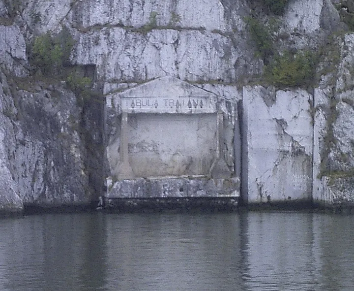
Around 100, while the legions cut a military road along the Iron Gates gorge – the work the Tabula Traiana inscription commemorates – Trajan's staff faced the harder problem: the Danube itself. The road could march an army to the river; only a bridge could march it across.
Dio's description is the whole ancient survey we have: twenty piers set in a river 'so deep', in water 'so full of eddies', on 'a bottom so muddy' that diverting the stream was impossible. The engineers chose the narrowest practicable point – and paid for it, because the contracted current ran all the more violent and deep.

Today the Danube is 800 metres wide at the site, and the ancient depth is undocumented: Dio gives words, not numbers. The only figure ever attached to the spot is a modern one – Murray's Handbook, about 1875, sounding 18 feet – and the Iron Gates dams of 1972 and 1984 have turned the whole reach into a reservoir since.
How, then, could one fail to be astonished at the way in which each of them was placed in a river so deep, in water so full of eddies, and on a bottom so muddy? For it was impossible, of course, to divert the stream anywhere.
Cassius Dio 68.13 (Cary transl., 1925)
Meanwhile While the engineers sounded the narrows, the road gangs were still cutting Trajan's highway through the gorge below.
Chapter II
Twenty piers
103 – 105 · Apollodorus spans the Danube
- Chapter
- 103 – 105
- Built
- 103–105
- Total length
- 1,135 m
- Piers
- 20 of stone
Between the spring of 103 and the spring of 105, Apollodorus of Damascus – the architect of the Column – spanned the Lower Danube east of the Iron Gates. The purpose was blunt: to carry Trajan's troops and supplies into the Second Dacian War against Decebalus.
Dio counted twenty piers of squared stone, 150 feet high above their foundations and 60 wide, standing 170 feet apart and joined by arches. Modern convention renders the whole as 1,135 metres long, 15 wide and 19 high above the water, with 38-metre wooden arches on brick-and-pozzolana masonry; each pier rose inside its own wooden caisson, and a fort guarded each end.
.jpg)
The bricks still found around Kostol name the builders: the legions IV Flavia Felix, VII Claudia, V Macedonica and XIII Gemina, with the cohorts I Cretum, II Hispanorum, III Brittonum and I Antiochensium. Their stamps are the site's muster roll, two thousand years on.
Trajan constructed over the Ister a stone bridge for which I cannot sufficiently admire him. Brilliant, indeed, as are his other achievements, yet this surpasses them.
Cassius Dio 68.13 (Cary transl., 1925)
Meanwhile The bridge was finished in 105; the Second Dacian War it served ran 105–106 and ended with Dacia a province.
Chapter III
The demolition
117 – 138 · Hadrian's decision
- Chapter
- 117 – 138
- Hadrian reigns
- 117–138
- Superstructure
- removed
- Piers in Dio's day
- still standing
At some point in Hadrian's reign – no source gives the year – the wooden superstructure came down. Dio states the reason as plainly as a dispatch: Trajan had built the bridge fearing war across a frozen Danube, and Hadrian feared the same road in reverse, once barbarians overpowered its guard, carrying invasion into Moesia.
The Romanian account names the pressure on the frontier: the Roxolani and the Iazyges. One late report says the superstructure was destroyed by fire; the rest was abandonment, completed when Rome finally gave up Dacia in 275.

Only the timber went. Dio, writing a century later, found the stone piers still standing and the crossing gone – monuments, as he put it, to the proposition that human ingenuity can accomplish anything.
Hadrian, on the contrary, was afraid that it might also make it easy for the barbarians, once they had overpowered the guard at the bridge, to cross into Moesia, and so he removed the superstructure.
Cassius Dio 68.13 (Cary transl., 1925)
Meanwhile Seven years after the Second Dacian War, on 12 May 113, Trajan dedicated the Column that still tells the bridge's story – the sister project.
Chapter IV
What the water kept
1689 – 1984 · surveys, floods and dams
- Chapter
- 1689 – 1984
- Marsigli surveys
- 1689
- Piers mapped, 1982
- 12 under water
- Iron Gate II
- 1984
In 1689 the Habsburg engineer Luigi Ferdinando Marsigli surveyed the remains stone by stone and dreamed, unsuccessfully, of raising a new bridge beside them. His Danubius Pannonico-Mysicus of 1726 preserves the piers as the river left them; writing from personal observation, he gave the total length as probably 3,010 feet.
The nineteenth century watched the count fall. Thirteen piers still showed about 1875; a record low water in the 1850s – 1856 in the Romanian article, 1858 in the English, the year genuinely disputed – bared all twenty; the Danube Commission destroyed two pillars in 1906, sixteen remained under water in 1932, and twelve were mapped in 1982, four probably swept away.
.jpg)
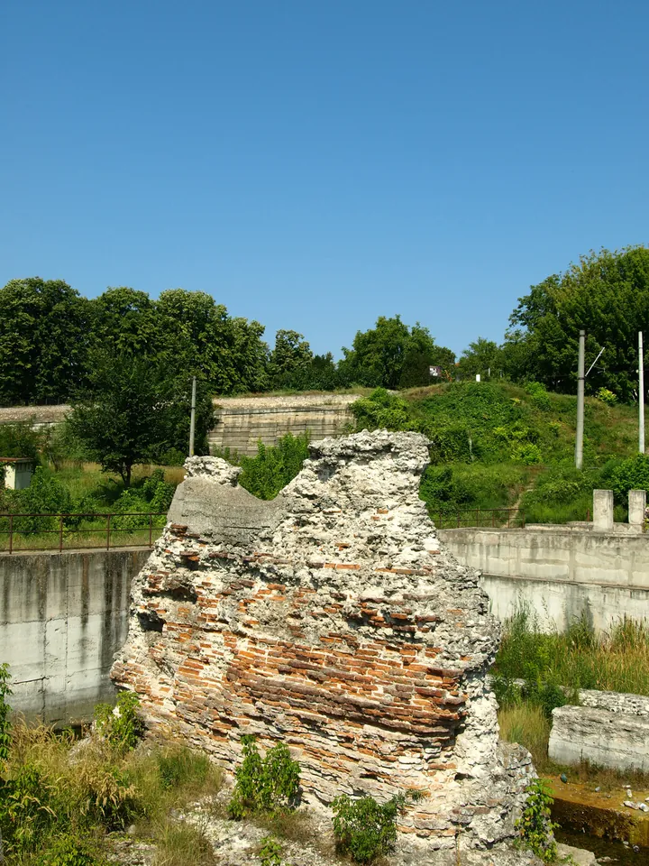
Then the dams rewrote the river: Iron Gate I in 1972, Iron Gate II in 1984, the valley drowned into a reservoir and the water up 35 metres near the dam. A 2003 underwater survey fixed the state of what survives; today the two entrance piers stand on their banks – the northern one in a concrete compound – and both states list the bridge as protected heritage.
The one point as to which it gives clear information, not supplied elsewhere, is that the superstructure was of wood.
Encyclopaedia Britannica, 9th ed., IV.373 (c.1875)
Meanwhile In 1972, while the reservoir rose 35 metres near the dam, the Tabula Traiana was lifted clear of the drowning gorge.
The bridge, pier by pier
Twenty piers, one river. Choose a witness to see what each count found, then pick a pier. Dimensions come from Dio; the river band shows the modern width and the only depth ever sounded here.
Dio's count. Twenty piers of squared stone, 150 feet high above the foundations, 60 wide, 170 feet apart, joined by arches – and, a century on, only the piers still standing.
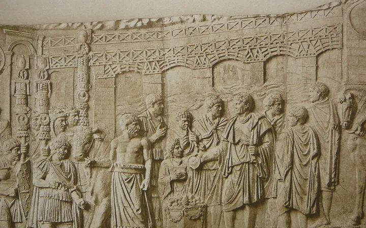
The Column. Scenes XCVIII–C show the bridge with fewer piers than Dio counted: a stylised crossing, 'almost wholly conventional' – but our only proof that the arches were timber.
Marsigli, 1726. Surveyed stone by stone in 1689, published in 1726: the piers as the river left them, and a total length of probably 3,010 feet by the Count's own observation.
Today. Two entrance piers on the banks and twelve mapped under water in 1982; a 2003 survey fixed their state, and both states protect them.
Pick a pier
Pier 1 of 20
Pier 1, the northern landfall at Drobeta: still visible on the Romanian bank, inside its concrete compound against the reservoir.
Pier 2 of 20
This pier's individual survival is undocumented: in 1982 archaeologists mapped twelve piers under water, and four more had probably been swept away.
Pier 3 of 20
This pier's individual survival is undocumented: in 1982 archaeologists mapped twelve piers under water, and four more had probably been swept away.
Pier 4 of 20
This pier's individual survival is undocumented: in 1982 archaeologists mapped twelve piers under water, and four more had probably been swept away.
Pier 5 of 20
This pier's individual survival is undocumented: in 1982 archaeologists mapped twelve piers under water, and four more had probably been swept away.
Pier 6 of 20
This pier's individual survival is undocumented: in 1982 archaeologists mapped twelve piers under water, and four more had probably been swept away.
Pier 7 of 20
This pier's individual survival is undocumented: in 1982 archaeologists mapped twelve piers under water, and four more had probably been swept away.
Pier 8 of 20
This pier's individual survival is undocumented: in 1982 archaeologists mapped twelve piers under water, and four more had probably been swept away.
Pier 9 of 20
This pier's individual survival is undocumented: in 1982 archaeologists mapped twelve piers under water, and four more had probably been swept away.
Pier 10 of 20
This pier's individual survival is undocumented: in 1982 archaeologists mapped twelve piers under water, and four more had probably been swept away.
Pier 11 of 20
This pier's individual survival is undocumented: in 1982 archaeologists mapped twelve piers under water, and four more had probably been swept away.
Pier 12 of 20
This pier's individual survival is undocumented: in 1982 archaeologists mapped twelve piers under water, and four more had probably been swept away.
Pier 13 of 20
This pier's individual survival is undocumented: in 1982 archaeologists mapped twelve piers under water, and four more had probably been swept away.
Pier 14 of 20
This pier's individual survival is undocumented: in 1982 archaeologists mapped twelve piers under water, and four more had probably been swept away.
Pier 15 of 20
This pier's individual survival is undocumented: in 1982 archaeologists mapped twelve piers under water, and four more had probably been swept away.
Pier 16 of 20
This pier's individual survival is undocumented: in 1982 archaeologists mapped twelve piers under water, and four more had probably been swept away.
Pier 17 of 20
This pier's individual survival is undocumented: in 1982 archaeologists mapped twelve piers under water, and four more had probably been swept away.
Pier 18 of 20
This pier's individual survival is undocumented: in 1982 archaeologists mapped twelve piers under water, and four more had probably been swept away.
Pier 19 of 20
This pier's individual survival is undocumented: in 1982 archaeologists mapped twelve piers under water, and four more had probably been swept away.
Pier 20 of 20
Pier 20, the southern landfall at Pontes-Kostol: still visible on the Serbian bank.
The elevation is drawn from Dio's count of 20 piers and the conventional total of 1,135 metres; pier spacing follows the sources, not a new survey.
Hadrian's decision
Four decisions replay the thesis: the timber, the stone, the coin, the architect. Choose as Hadrian, then check the sources.
-
1
The timber
The guard is thin and the Danube freezes. The wooden roadway you inherited shortens every barbarian road into Moesia. What does Hadrian do with the superstructure?
What happened
He removes it. Dio 68.13: Hadrian feared the bridge would make it easy for the barbarians, once they had overpowered the guard, to cross into Moesia.
-
2
The stone
The timber is gone but twenty stone piers still march across the river, proof of what Rome can build. Does Hadrian pull them down too?
What happened
He leaves them. Dio, a century later: 'merely the piers are standing, affording no means of crossing.'
-
3
The coin
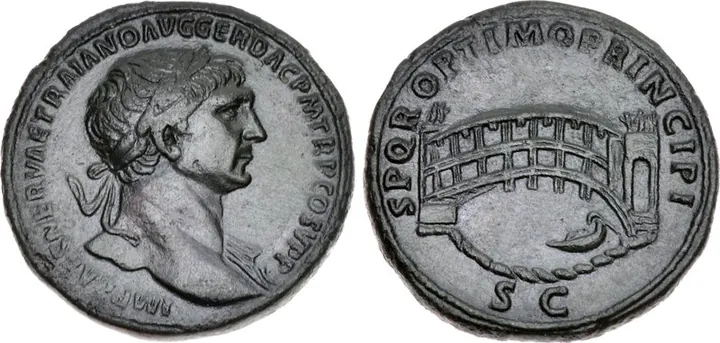
A sestertius of 107–110 shows a single-span bridge over a river, a boat below. Catalogues call it the Danube bridge. How certain is that?
What happened
Disputed. CNG calls it 'generally thought' to be Apollodorus's Danube bridge of 104; Heritage hedges every listing with 'Danube or Tiber?'.
-
4
The architect
Apollodorus mocked your drawings to your face – 'draw your gourds' – and shredded your Temple of Venus and Roma: the goddesses could not even stand up inside. You are emperor now. What happens to him?
What happened
Exile, then death. Dio 69.4: Hadrian 'remembered this slight and would not endure the man's freedom of speech' – about the man, not the bridge.
Decide a card to begin.
Seven plates of the bridge
Seven plates in the order of the story: the road, the Column, the coin, Marsigli's three surveys of 1726, and the pier that stands today. Tap a plate to read it.
Plate c.100The road before the bridge
The road before the bridge Tabula Traiana, photo: Rlichtefeld, CC BY-SA 3.0 · Wikimedia Commons - The Tabula Traiana, cut into the Kazan gorge about 100, commemorates Trajan's military road to the river.
- The road gangs worked while the bridge was still a decision: highway first, crossing second.
- In 1972 the plaque was lifted clear of the reservoir that drowned its cliff.
Plate XCVIII–CThe bridge on the Column
The bridge on the Column Cichorius, Die Reliefs der Traianssäule II, plate LXXII (1900), public domain · Wikimedia Commons - Scenes XCVIII–C compress the crossing into a handful of arches: fewer piers than Dio's twenty.
- The 9th Britannica calls the relief 'almost wholly conventional' – a symbol, not a survey.
- Its one hard fact: the superstructure was of wood.
Plate 107–110The coin that may show it
The coin that may show it Bridge sestertius, photo: CNG, CC BY-SA 2.5 · Wikimedia Commons - A sestertius of 107–110: a bridge, a boat below, SPQR OPTIMO PRINCIPI.
- CNG: 'generally thought' to be the Danube bridge of 104.
- Heritage, every time: 'Danube or Tiber?' – the honest answer is the question.
Plate 1726 · IThe reach at Severin
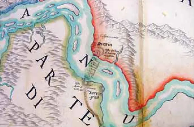
The reach at Severin Marsigli, Danubius Pannonico-Mysicus (1726), public domain · Wikimedia Commons - The 1726 watercolor: the Danube bend at Severin, islands, banks and mountains washed in colour.
- Marsigli drew the reach from life during his survey years after 1689.
- The bridge's stones are not drawn here: this sheet sets the scene, the crossing's river.
Plate 1726 · IIThe map of the ruins
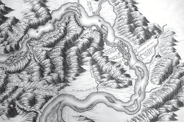
The map of the ruins Marsigli, Danubius Pannonico-Mysicus (1726), public domain · Wikimedia Commons - The 1726 map winds the Danube through the gorge, from Orsova past Severin.
- 'PONT TRAJAN' is marked at Severin, beside 'CASTRAMETATIO': the bridge as a place on the river.
- Roman ruins line both banks – Antiq. Rom., a vallum, a paved way – the bridge's frontier world.
Plate 1726 · IIIThe fort on the bank
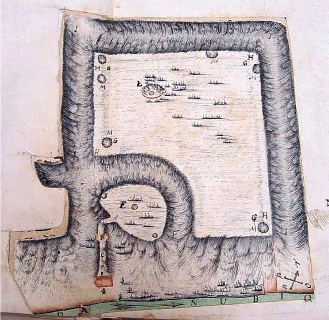
The fort on the bank Marsigli, Danubius Pannonico-Mysicus (1726), public domain · Wikimedia Commons - A walled enclosure on the Danube – 'DANUBIO' runs along the sheet's foot – drawn as a surveyor's plan.
- Lettered stations ring the circuit: Marsigli the engineer, measuring stone by stone.
- The bridge ended in gates like these: Dio's guard stood in forts, not in the open.
Plate 2009The pier that stands
The pier that stands Drobeta pier 2009, photo: Dan Mihai Pitea, CC BY-SA 3.0 ro · Wikimedia Commons - The northern landfall at Drobeta in 2009: Roman brick inside a concrete compound.
- The compound holds back the Iron Gate II reservoir, opened 1984.
- The southern twin stands on the Serbian bank: two piers of twenty, kept.


Plates: Marsigli 1726 and Cichorius 1900 via Wikimedia Commons; the coin via CNG; modern photos as credited. References are plate numbers and dates.
The bridge in six numbers
Every figure below comes from the cited sources. Variant measurands are named in the chapters, not merged.
- 1,135
- metres of bridge, end to end
- 20
- stone piers, Dio's count
- 38
- metres of wooden arch per span
- 800
- metres of Danube at the site today
- 105
- the year the bridge was finished
- 1,726
- Marsigli publishes the surveys
Three things people get wrong
Hadrian demolished the bridge from jealousy of Trajan.
Dio gives a soldier's reason, not a grudge: the bridge made invasion easy once its guard fell, so Hadrian removed the superstructure to shield Moesia. The jealousy story exists – but it is about Apollodorus the man (Dio 69.4: exile, then death for his bluntness), and that chapter never mentions the bridge. The gossip migrated from the architect to his work.
The bridge was a stone-arch bridge.
The piers were stone; the roadway was timber. The Column's relief is stylised in every proportion, yet the 9th Britannica grants it exactly one hard fact: the superstructure was of wood – 38-metre arches on masonry, not stone vaults.
Nothing of the bridge survives.
Two entrance piers stand on the banks – Drobeta's in its concrete compound, Pontes-Kostol's on the Serbian side – twelve more were mapped under water in 1982, and a 2003 survey fixed their state. Serbia listed the bridge in 1979 and Romania in 2004: it survives as law as well as stone.
Sources and methods
Figures follow the cited sources: Dio's feet stay feet, modern metres stay metres, and variant totals (1,135; 1,127/1,071; 1,097.50) are shown as labelled alternatives. What cannot be proven – the demolition year, the ancient current's speed, the 1856/1858 year – is marked disputed or undocumented, never smoothed over.
Quotations from Dio follow the Cary translation of 1925 (public domain); the Romanian renderings are our own, checked against Cary. The Britannica passage is quoted from the 9th edition text on Wikisource.
Map lines are representative paths through verified places, drawn dashed; the pier-by-pier elevation is dimensioned from Dio and the 1,135-metre convention, with per-pier survival stated only where documented.
The river that would not move
- Cassius Dio, Roman History 68.13 (Cary transl., 1925): the deep river, full of eddies, with a muddy bottom; the narrowest practicable point (LacusCurtius)
- Wikipedia, Tabula Traiana: Trajan's military road through the Kazan gorge, c.100; moved in 1972, waters up 35 metres
- Wikipedia, Trajan's Bridge: the Danube is 800 metres wide at Drobeta today
Twenty piers
- Cassius Dio 68.13 (Cary transl., 1925): 20 piers of squared stone, 150 feet high, 60 wide, 170 apart, connected by arches (LacusCurtius)
- Wikipedia, Trajan's Bridge: 103–105, Apollodorus of Damascus, 1,135 metres, 38-metre wooden arches, caissons, a castrum at each end
- Procopius, Buildings IV.6: Apollodorus's lost treatise, he the master-builder of the whole work
The demolition
- Cassius Dio 68.13 (Cary transl., 1925): Hadrian's fear – barbarians crossing into Moesia – and the removal of the superstructure; the piers still standing
- Cassius Dio, Roman History 69.4 (Cary transl., 1925): Apollodorus exiled, then put to death; 'draw your gourds'; the Temple of Venus and Roma (LacusCurtius)
- The wars' telling, scene by scene: the sister project Trajan's Column
What the water kept
- Encyclopaedia Britannica, 9th ed., vol. IV, p. 373 (c.1875): 13 piers visible, Marsigli 3,010 feet, Murray 18 feet of depth (Wikisource)
- Wikipedia, Podul lui Traian (ro) and Trajan's Bridge (en): 1906, 1932, 1982; the disputed 1856/1858 year; the MH-I-m-A-10047.04 listings
- Wikipedia, Iron Gates: Iron Gates I (1972) and II (1984); the reservoir; +35 metres; Ada Kaleh
The reconstruction
The seven plates
Images
- Tabula Traiana, photo: Rlichtefeld, CC BY-SA 3.0 · Wikimedia Commons
- Cichorius, Die Reliefs der Traianssäule II, plate LXXII (1900), public domain · Wikimedia Commons
- Bridge sestertius, photo: CNG, CC BY-SA 2.5 · Wikimedia Commons
- Marsigli, Danubius Pannonico-Mysicus (1726), public domain · Wikimedia Commons
- Marsigli, Danubius Pannonico-Mysicus (1726), public domain · Wikimedia Commons
- Marsigli, Danubius Pannonico-Mysicus (1726), public domain · Wikimedia Commons
- Drobeta pier 2009, photo: Dan Mihai Pitea, CC BY-SA 3.0 ro · Wikimedia Commons