Chapter 3 · Inside the EarthLesson 3.4
Endogenous hazards: earthquakes and volcanoes
In 1977, the earthquake began in Vrancea, yet most victims were in Bucharest, over 150 km away. Why?
Before you read: what do you think?
The earthquake of 4 March 1977 began in Vrancea. Focșani was 46 km from the epicentre, Bucharest 167 km. Where was the shaking stronger?
See the answer
Bucharest. The intensity was VIII in Bucharest and VII in Focșani on the Mercalli scale. The focus was 94 km underground, so both cities were far from it; the direction of the rupture, the soft ground beneath Bucharest and its tall, old buildings mattered more.
On 4 March 1977, rock ruptured 94 km beneath the Vrancea Mountains. In Bucharest, 167 km from the epicentre, 32 large buildings collapsed partly or completely. Nine in ten victims of the earthquake were in the capital.
An earthquake starts at a point underground
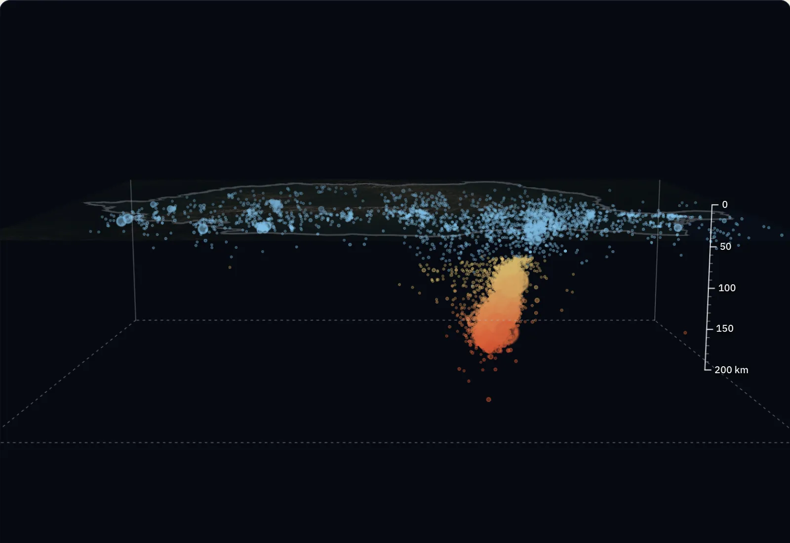
An earthquake occurs when rocks strained by plate movement suddenly break along a fault. In 1977, the rupture began 94 km beneath the Vrancea Mountains. The place underground where rupture begins is called the hypocentre or focus. The point on the surface directly above it is called the epicentre.
Seismic waves travel out from the hypocentre. P waves, the fastest, arrive first and are felt as a short vertical jolt. S waves follow and shake the ground harder. Surface waves arrive last and cause most of the damage.
By the depth of the hypocentre, earthquakes are shallow (up to about 70 km), intermediate (between 70 and 300 km) or deep (up to about 700 km). Earthquakes and volcanic eruptions originate inside the Earth; dangerous events of this kind are called endogenous hazards.
One magnitude, different intensities
Magnitude shows how much energy an earthquake releases at its focus. It is calculated from seismograph recordings and has a single value for an earthquake, wherever it is felt. The best-known scale is the Richter scale; today seismologists use moment magnitude (Mw). The scale is logarithmic: for each extra unit, the ground motion recorded by a seismograph is ten times greater.
Intensity shows how strongly an earthquake was felt and how much damage it caused in a particular place. It is expressed in degrees on the Mercalli scale, from I to XII, written in Roman numerals. The same earthquake has different intensities in different places, depending on distance, the depth of the focus, the ground and the quality of buildings.
| Earthquakes with Mw ≥ 2.5, 1977 – February 2026 | Number | Depth of the focus |
|---|---|---|
| crustal, across the country | 2,829 | under 60 km |
| intermediate depth, under Vrancea | 7,726 | nine in ten between 73 and 152 km |
| 10 November 1940 | 7.7 Mw | 150 km |
| 4 March 1977 | 7.4 Mw | 94 km |
| A focus 100 km under Vrancea | Path of the waves | P wave | S wave |
|---|---|---|---|
| Bucharest | 177 km | 22 s | 39 s |
| Iași | 206 km | 26 s | 46 s |
| Cluj-Napoca | 278 km | 35 s | 62 s |
Measurements and calculation. The relief is the Copernicus GLO-30 model, averaged over cells of about 1 km and drawn at 1× scale on a flat block, without the curvature of the Earth; the shading is strengthened so that the forms show. The dots are the 10,623 earthquakes with Mw ≥ 2.5 and a calculated depth in the ROMPLUS catalogue of the National Institute for Earth Physics (INFP), 1977 – February 2026, plus the earthquake of 10 November 1940. The wave fronts are calculated with average speeds. The bands of the crust and lithosphere are a diagram with average values.
Earthquakes and volcanoes follow plate edges
Fewer than 10% of earthquakes occur within plates; the rest occur at their edges. The most active zone is the Pacific Ring of Fire, the chain of trenches and volcanoes that surrounds the Pacific Ocean, from Chile to Japan and New Zealand. The second is the Alpine–Himalayan belt, from the Mediterranean Sea to Indonesia, which includes Romania. The third follows the ocean ridges.
When a powerful earthquake suddenly raises or lowers the ocean floor, the water above it travels in waves called a tsunami. In the open ocean they are low and fast; near shore they slow down and rise.
For the curious
In the open ocean, tsunami waves reach speeds of up to 960 km/h; at the coast they can rise to 15 m or more.
Volcanoes: where magma comes out
A volcano is a place where magma reaches the surface. Magma collects in a chamber underground, rises through a vent and emerges through the crater as lava, ash, pieces of rock and gases. These materials build the volcanic cone around the crater.
A volcano’s shape depends on its lava. Fluid lava flows far and builds broad shield volcanoes with gentle slopes, like Mauna Loa in Hawaii. Viscous lava blocks the vent, and eruptions are explosive; layers of lava and ash build stratovolcanoes, tall, steep cones like Fuji. Volcanoes are classified as active or extinct according to their activity.
For the curious
There are also small cinder cones and lava domes.
What to do in an earthquake
An earthquake cannot be stopped or predicted to the day and hour. The damage, however, depends on buildings and on how people behave.
If you are inside a building, stay inside. Move away from windows, outside walls and furniture that could fall, and shelter beside a load-bearing wall or under a sturdy table. Do not run down the stairs, go onto a balcony or use the lift. If you are outside, stay away from buildings, poles and power lines.
Worked example
One magnitude, three intensities in 1977
The earthquake of 4 March 1977 had a magnitude of 7.4 Mw. That is the value for the earthquake, the same for Focșani, Bucharest and everywhere else.
The intensities differed. In the epicentral area, intensity reached IX. At Focșani, 46 km from the epicentre, it was VII. At Bucharest, 167 km from the epicentre, it was VIII.
The more distant city was hit harder. Distance from the epicentre alone does not determine intensity. The focus was 94 km underground, so both cities were far from it. The direction of the rupture, the soft ground beneath Bucharest and its tall, old buildings mattered more. The answer to “what was the earthquake’s magnitude in Bucharest?” is still 7.4; the intensity is what differs.
In Romania
Vrancea and Ciomadul volcano
The Vrancea seismic zone, at the bend of the Carpathians, produces intermediate-depth earthquakes: the main activity takes place between 60 and 180 km deep. Because they start so far down, they are felt over very large areas.
The earthquake of 10 November 1940 had a magnitude of 7.7 Mw and a focus 150 km deep. There were 593 recorded deaths and 1,271 injuries; in Bucharest the Carlton apartment block collapsed. The earthquake of 4 March 1977 had a magnitude of 7.4 Mw and a focus at 94 km. It killed 1,578 people, 90% of them in Bucharest, and injured more than 11,300.
Romania’s volcanoes are extinct. The youngest is Ciomadul, in the southern Harghita Mountains, which last erupted about 30,000 years ago; Lake Sfânta Ana lies in one of its craters.
Your place
How far is your place from the Vrancea seismic zone, and after how many seconds would the waves of an earthquake arrive?
In brief
- The hypocentre (focus) is the place underground where rock begins to rupture; the epicentre is the point on the surface above it.
- Magnitude measures the energy released at the focus and has one value for an earthquake; intensity measures the effects in a place, on the Mercalli scale from I to XII, and differs between places.
- P waves arrive first, S waves follow, and surface waves cause most of the damage.
- Earthquakes and volcanoes cluster at plate edges: the Pacific Ring of Fire, the Alpine–Himalayan belt and ocean ridges.
- Fluid lava builds shield volcanoes with gentle slopes; viscous lava produces explosive eruptions and steep stratovolcanoes.
- In Romania, the Vrancea zone produces intermediate-depth earthquakes (60–180 km), such as those of 10 November 1940 (7.7 Mw) and 4 March 1977 (7.4 Mw, 1,578 deaths).
Common mistakes
WrongThe 1977 earthquake was 7.4 in Vrancea and less in Bucharest.
RightAn earthquake has one magnitude: 7.4 Mw. Intensity, measured in Mercalli degrees, differs from place to place.
WrongThe epicentre is the place underground where the earthquake occurs.
RightThe place underground is the hypocentre (focus). The epicentre is the point on the surface above it.
WrongDuring an earthquake you should run straight out of the building.
RightOn the stairs you could fall or be hit by material falling from the building, and the lift could get stuck. Stay inside, sheltered and away from windows, until the shaking stops.
Test yourself
Six questions. For the first five you see the explanation at once, with the paragraph of the lesson that supports it; for the ones with a written answer you compare with a good answer.
What is the point on the Earth’s surface directly above the place where the rock broke called?
Answer
b) Epicentre. Hypocentre and focus name the same place underground. The epicentre is the point directly above it on the surface.
An earthquake was felt strongly in one city and weakly in another. Which measure differed between the two cities?
Answer
a) Intensity. Magnitude, hypocentre and epicentre belong to the earthquake and are the same everywhere. Intensity describes the effects at each place.
At what depth does the main seismic activity in the Vrancea zone occur?
Answer
d) Between 60 and 180 km. Major Vrancea earthquakes occur at intermediate depth, below the crust. That is why they are felt over very large areas.
What kind of volcano is built by viscous lava and explosive eruptions?
Answer
c) A tall, steep stratovolcano. Viscous lava does not flow far; layers of lava and ash accumulate near the crater and build a steep cone. Fluid lava forms shield volcanoes.
How many times greater is the ground motion recorded by a seismograph for a magnitude 7 earthquake than for a magnitude 5 earthquake at the same distance?
timesAnswer
100 times. There are two units between 5 and 7, and each unit means ten times as much: 10 × 10 = 100.
You are in a classroom on the second floor when an earthquake begins. A classmate shouts, “Everyone down the stairs and outside!” What do you do, and how do you explain why that advice is dangerous?
A good answer
I stay in the classroom, move away from windows and cupboards and shelter under a desk, holding on to it until the shaking stops. Stairs are among the most dangerous places during an earthquake: people fall, trample one another or are hit by material falling from the building. Leave the building only after the shaking stops, using the stairs, without the lift.
A complete answer says what you do (stay, shelter, keep away from windows), why you do not run down the stairs and when to leave the building.
Terms
- endogenous hazard
- A dangerous natural event that originates inside the Earth, such as an earthquake or volcanic eruption.
- hypocentre
- The place underground where rocks begin to rupture in an earthquake; also called the focus.
- epicentre
- The point on the Earth’s surface directly above the hypocentre.
- magnitude
- A measure of the energy released by an earthquake at its focus; an earthquake has one magnitude.
- intensity
- A measure of an earthquake’s effects in a particular place, expressed in degrees on the Mercalli scale (I–XII).
- tsunami
- Huge waves caused by a sudden movement of the seabed, usually during an earthquake.
- volcano
- A place where magma reaches the surface, consisting of a magma chamber, vent, crater and cone.
Sources and link to the programme
- INCDFP – Turul ghidat „Bucureștii și Cutremurele”, 28 februarie 2026 – 4 March 1977: 7.4 Mw, 94 km depth, 90% of victims in Bucharest, 32 buildings partly or completely collapsed
- INCDFP – Turul ghidat „Bucureștii și Cutremurele”, 8 noiembrie 2026 – 10 November 1940: 7.7 Mw, 150 km depth, collapse of the Carlton apartment block
- Agerpres – Fragment de istorie: cutremurul devastator din 10 noiembrie 1940 – 1940: 593 recorded deaths and 1,271 injuries, citing infp.ro (estimates rise towards 1,000 deaths)
- Banca Mondială (Simpson, Pomonis, Georgescu, 2020) – How Romanians are turning a hidden legacy of seismic risk into an opportunity – 1977: 1,578 deaths (90% in Bucharest) and more than 11,300 injuries
- INCDFP – Raportul proiectului AFROS, 2021 – Vrancea: main seismic activity at intermediate depths, 60–180 km
- Kronrod, Panza, Radulian, 2012 – date macroseismice pentru cutremurele vrâncene (PANGAEA) – 1977: intensity VIII in Bucharest (167 km from the epicentre), VII in Focșani (46 km), IX in the epicentral area
- USGS – Earthquakes: How earthquakes happen – Focus and epicentre; depth classes (up to 70 km, 70–300 km, up to 700 km); tsunami at up to 960 km/h and 15 m at the coast
- USGS – Earthquakes: Measuring earthquakes – Magnitude and intensity; logarithmic Richter scale (ten times per unit); Mercalli scale from I to XII
- USGS – Earthquakes: Where earthquakes occur – Fewer than 10% of earthquakes occur inside plates; global seismic zones
- USGS – This Dynamic Earth: Ring of Fire – Pacific Ring of Fire: volcanic arcs and trenches around the Pacific Ocean, a zone of frequent earthquakes and eruptions
- USGS – Volcanoes (Robert I. Tilling): principal types of volcanoes – Volcano types: cinder cones, stratovolcanoes (composite), shield volcanoes, lava domes; Mauna Loa, Fuji
- Molnár și colab., 2019 – Episodes of dormancy and eruption of the Late Pleistocene Ciomadul volcanic complex, Journal of Volcanology and Geothermal Research 373 – Ciomadul, the youngest volcano in the Carpathian–Pannonian region, active until about 30,000 years ago
- ISU Giurgiu (IGSU) – Astăzi: 47 de ani de la cutremurul din 1977 – Earthquake safety: stay inside, away from windows and outside walls; do not run down stairs, go onto a balcony or use a lift; outside, keep away from buildings and cables
From the programme: “Endogenous hazards. Seismicity and volcanism” (common core). Programme competences covered: 2.2, 3.3, 5.2.