Chapter 3 · Inside the EarthLesson 3.3
Earth’s internal dynamics: plate tectonics and mountain building
Iceland widens by about 2.5 cm each year. What is pulling its edges apart?
Before you read: what do you think?
The Mid-Atlantic Ridge opens by 2.5 cm a year, about as fast as fingernails grow. How far apart do the shores of the Atlantic move in a million years?
See the answer
25 km. 2.5 cm/year × 1,000,000 years = 2,500,000 cm, or 25 km. A movement too slow to feel opens an ocean over geological time.
A long crack runs through the middle of Iceland, with volcanoes and hot springs along it. The North American Plate lies on one side, the Eurasian Plate on the other. They move apart by about 2.5 cm a year, and the island grows with them.
The lithosphere is a mosaic of plates
Iceland sits on two pieces of the lithosphere, the planet’s rigid outer shell, which are moving apart. The lithosphere is broken into about 12 large pieces like these, called tectonic plates or lithospheric plates. Seven are major plates: the Pacific, Eurasian, North American, South American, African, Indo-Australian and Antarctic plates.
A plate is a different thing from a continent. The African Plate includes the African continent and part of the floor of the Atlantic and Indian oceans. The Pacific Plate consists almost entirely of ocean floor.
In 1912, the German meteorologist Alfred Wegener proposed the theory of continental drift. The theory of plate tectonics later explained the mechanism.
For the curious
Smaller plates, such as the Nazca, Arabian and Philippine plates, lie among the major ones.
Wegener argued that all the continents had once been joined in a supercontinent, Pangaea, which began to break apart about 200 million years ago.
| Place | How the earthquakes line up | Depth of the foci | Type of boundary |
|---|---|---|---|
| Mid-Atlantic Ridge | a narrow string through the middle of the ocean | all 2,652 under 70 km | divergent |
| Japan (Pacific Ring of Fire) | a wide band, from the trench towards the continent | 15% deeper than 70 km, down to 588 km | convergent, with subduction |
| Andes (Pacific Ring of Fire) | a band along the coast | 37% deeper than 70 km, down to 651 km | convergent, with subduction |
| Himalayas and the Tibetan Plateau | a strip hundreds of kilometres wide | 99% under 70 km | convergent, between two continents |
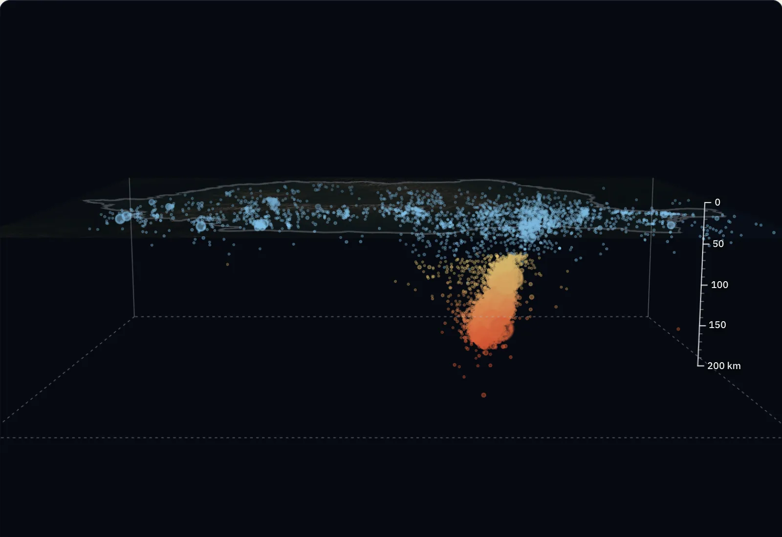
| Vrancea | a tight cluster, beneath the bend of the Carpathians | 28 earthquakes between 88 and 164 km | far from today’s boundaries |
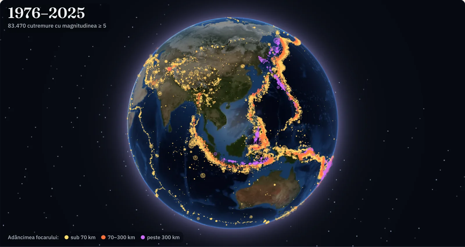
In all, 83,470 earthquakes of magnitude 5 or more in 1976–2025: 66,506 with the focus under 70 km, 13,010 between 70 and 300 km, 3,954 deeper than 300 km. The catalogue is a record of what has happened.
Measurements. Each dot is an earthquake of magnitude 5 or more from the catalogue of the United States Geological Survey (USGS), 1976–2025: 83,470 in all. The position and depth are those calculated by seismologists from the recordings; the dots are larger for larger magnitudes, and their size on the globe does not show the area affected. The plate boundaries are those of the PB2002 model (Bird, 2003), without the boundary between India and Australia, which the lesson treats as a single plate. The globe is a mosaic of satellite photographs (NASA Blue Marble), darkened so that the dots show. The catalogue is a record of what has happened and does not show when or where the next earthquake will be.
Heat from within drives the movement
Mantle rocks are solid but hot, and they deform slowly. Warmer, lighter material rises, cools beneath the lithosphere, becomes denser and sinks again. These very slow circular movements are called convection currents. Together with the weight of cold plates sinking into the mantle, they set the plates in motion.
The speed is a few centimetres a year, about as fast as fingernails grow. The Mid-Atlantic Ridge opens by an average of 2.5 cm a year. The fastest spreading, at more than 15 cm a year, is measured on the East Pacific Rise, near Easter Island.
Divergent boundaries: plates move apart
At a divergent boundary, two plates move apart. Magma rises through the opening, cools and forms fresh oceanic crust. On the ocean floor, this process has built ocean ridges, chains of underwater mountains thousands of kilometres long, such as the Mid-Atlantic Ridge.
On a continent, separation starts with a rift, a long, deep valley bounded by faults, with volcanoes and lakes. The Great African Rift is one such place, where a continent has begun to split.
Convergent boundaries: plates come together
At a convergent boundary, two plates collide. When one has denser oceanic crust, it passes beneath the other and sinks into the mantle. This process is called subduction. The place where the plate bends and descends is an ocean trench, the deepest landform on the planet. The Nazca Plate passes beneath South America in this way: the Peru–Chile Trench lies offshore, and the Andes, with their active volcanoes, have risen on the continent.
When two continents meet, neither sinks deep into the mantle, because continental rocks are too light. One is pushed beneath the edge of the other, and the crust thickens. The rock layers between them are squeezed, folded and pushed upwards. This is how the Himalayas rose, from the collision of India with Eurasia. The formation of a mountain range through folding and uplift of the crust is called orogeny.
Transform boundaries: plates slide past each other
At a transform boundary, plates rub past each other sideways, without crust being formed or consumed. Along the San Andreas Fault in California, the Pacific Plate slides past the North American Plate at about 5 cm a year.
At all three types of boundary, rocks become locked, build up strain and suddenly give way. That is why earthquakes and volcanoes are found almost entirely along plate edges.
For the curious
The San Andreas Fault is about 1,300 km long.
Worked example
How much the Atlantic widens
The Mid-Atlantic Ridge opens by an average of 2.5 cm a year. The question: how far apart do the shores move in a million years?
Multiply the rate by the time: 2.5 cm/year × 1,000,000 years = 2,500,000 cm. Convert to kilometres: 100,000 cm make 1 km, so 2,500,000 cm = 25 km.
In 100 million years, at the same rate, the result is 25 km × 100 = 2,500 km. A movement too slow to feel opens an ocean over geological time. During an 80-year lifetime, the same ridge widens by 2.5 cm × 80 = 200 cm, or two metres.
In Romania
The Carpathians and the Alpine orogeny
The Carpathians are part of the same chain as the Alps and the Himalayas and formed during the Alpine orogeny, the most recent major period of mountain building. Branches of the Tethys Ocean, which separated Africa from Europe, once occupied their place. As Africa approached Europe, these ocean branches closed through subduction, and the small continental blocks between them were pushed towards the edge of Europe.
Folding took place in several phases. The crystalline central part of the Carpathians was folded in the Cretaceous. The belt of flysch (sedimentary rocks in thin, alternating layers) on the outside of the Eastern Carpathians was folded and pushed over the edge of the platform in the Miocene; subduction here ended about 11 million years ago.
Its traces are still visible: the Oaș–Gutâi–Călimani–Gurghiu–Harghita volcanic chain on the inner side of the Eastern Carpathians, and the deep earthquakes of Vrancea.
In brief
- The lithosphere is broken into tectonic plates; the seven major plates are the Pacific, Eurasian, North American, South American, African, Indo-Australian and Antarctic plates.
- Plates move a few centimetres a year, driven by convection currents in the mantle.
- At divergent boundaries plates move apart and oceanic crust forms: rifts on continents, ridges in oceans.
- At convergent boundaries plates come together: subduction produces ocean trenches and mountains with volcanoes (the Andes), while the collision of two continents produces fold mountains (the Himalayas).
- At transform boundaries plates slide sideways past each other and produce earthquakes (the San Andreas Fault).
- Orogeny is mountain building through folding and uplift of the crust; the Carpathians formed during the Alpine orogeny.
Common mistakes
WrongTectonic plates are continents.
RightA plate is a piece of lithosphere and usually includes both land and ocean floor. The Pacific Plate is almost entirely ocean floor.
WrongPlates float on liquid magma.
RightPlates slide over the asthenosphere, a layer of the mantle made of solid rock that deforms slowly.
WrongAn empty chasm remains where plates separate.
RightAs the plates move apart, magma rises, cools and fills the space with fresh oceanic crust.
Test yourself
Six questions. For the first five you see the explanation at once, with the paragraph of the lesson that supports it; for the ones with a written answer you compare with a good answer.
What happens at a divergent boundary?
Answer
d) Plates move apart and oceanic crust forms. Divergent means that plates move apart; magma rising between them solidifies as oceanic crust.
How did the Himalayas form?
Answer
a) Through the collision of two continental plates. India and Eurasia are both continental, too light to descend into the mantle; the rocks between them were folded and raised.
Why does the oceanic plate, rather than the continental one, descend at a subduction zone?
Answer
b) Because oceanic crust is denser. Oceanic crust, made of basalt, is denser than continental crust, so it sinks into the mantle.
During which orogeny did the Carpathians form?
Answer
c) The Alpine orogeny. The Carpathians belong to the same chain as the Alps and Himalayas. The older Hercynian orogeny produced the Măcin Mountains; Quaternary glaciers merely shaped the high ridges.
Along the San Andreas Fault, plates slide past each other at about 5 cm a year. How many kilometres do they move in 10 million years?
kmAnswer
500 km. 5 cm/year × 10,000,000 years = 50,000,000 cm; divide by 100,000 cm/km to get 500 km.
Japan has many earthquakes and volcanoes, and a deep ocean trench lies offshore. What type of plate boundary do these three clues indicate, and what happens there?
A good answer
The trench, volcanoes and earthquakes indicate a convergent boundary with subduction. A denser oceanic plate bends, descends beneath its neighbour and sinks into the mantle; the trench marks where it descends. Friction between the plates produces earthquakes, while magma formed above the descending plate feeds volcanoes.
A complete answer names the convergent boundary and subduction and connects each clue (trench, earthquakes, volcanoes) to the descending oceanic plate.
Terms
- tectonic plate
- A large, rigid piece of lithosphere that moves slowly over the asthenosphere.
- convection currents
- Very slow circular movements of mantle rock: warm material rises and cooled material sinks.
- ocean ridge
- A chain of underwater mountains formed at a divergent boundary, where oceanic crust forms.
- rift
- A long valley bounded by faults, formed where a plate begins to split.
- subduction
- The descent of a plate with oceanic crust beneath another plate into the mantle.
- orogeny
- The formation of a mountain range through folding and uplift of the crust, usually at a convergent boundary.
- transform boundary
- A boundary where two plates slide sideways past each other, without crust being formed or consumed.
Sources and link to the programme
- USGS – This Dynamic Earth: Understanding plate motions – The three types of boundary; Mid-Atlantic Ridge 2.5 cm/year (25 km in a million years); East Pacific Rise over 15 cm/year; Iceland; Nazca and the Andes; the Himalayas; San Andreas Fault (1,300 km, 5 cm/year)
- USGS – This Dynamic Earth: Historical perspective – Wegener, 1912, continental drift; Pangaea began to break apart about 200 million years ago
- USGS – This Dynamic Earth: Moving slabs – The lithosphere broken into about 12 plates; plate map
- USGS – This Dynamic Earth: Some unanswered questions – Mantle convection currents and solid rocks that deform slowly
- Schmid și colab., 2008 – The Alpine-Carpathian-Dinaridic orogenic system, Swiss Journal of Geosciences 101 – Branches of the Tethys Ocean where the Carpathians now stand, the Tisia and Dacia continental blocks, Cretaceous folding and Miocene folding of the outer flysch
- Ustaszewski și colab., 2008 – A map-view restoration of the Alpine-Carpathian-Dinaridic system for the Early Miocene, Swiss Journal of Geosciences 101 – Carpathian subduction, which ended about 11 million years ago
From the programme: “Earth’s internal dynamics and associated phenomena” (common core). Programme competences covered: 1.3, 2.3, 4.5.