Chapter 3 · Elements of geology: internal dynamics, resources and hazards
What lies beneath Romania, and why does Vrancea have earthquakes?
Clock: a second and a million yearsScale: 6,371 km to the centre
The block shows Romania’s landforms, measured from a satellite. Beneath it lie the places where more than 10,000 recorded earthquakes have started since 1977, each at its own depth.
An earthquake has a place on the map and a depth
When an earthquake is announced, three things are given: the magnitude, the place on the map and the depth. The place on the map is the epicentre. The rock began to break below it, at a point called the hypocentre, or focus.
From what depth do you think Romania’s strong earthquakes start?
From above, 73% of the dots gather at the bend of the Carpathians
Each dot is the epicentre of an earthquake in the catalogue of the National Institute for Earth Physics (INFP): 10,623 earthquakes of magnitude at least 2.5, between 1977 and February 2026. A larger dot means a larger magnitude.
Blue dots appear across almost the whole country, from the Banat region in the west to the Dobrogea region in the south-east. Most of the dots, yellow and red, are crowded into a single place, at the bend of the Carpathians: the Vrancea seismic zone.
A map shows only epicentres. It says nothing about depth.
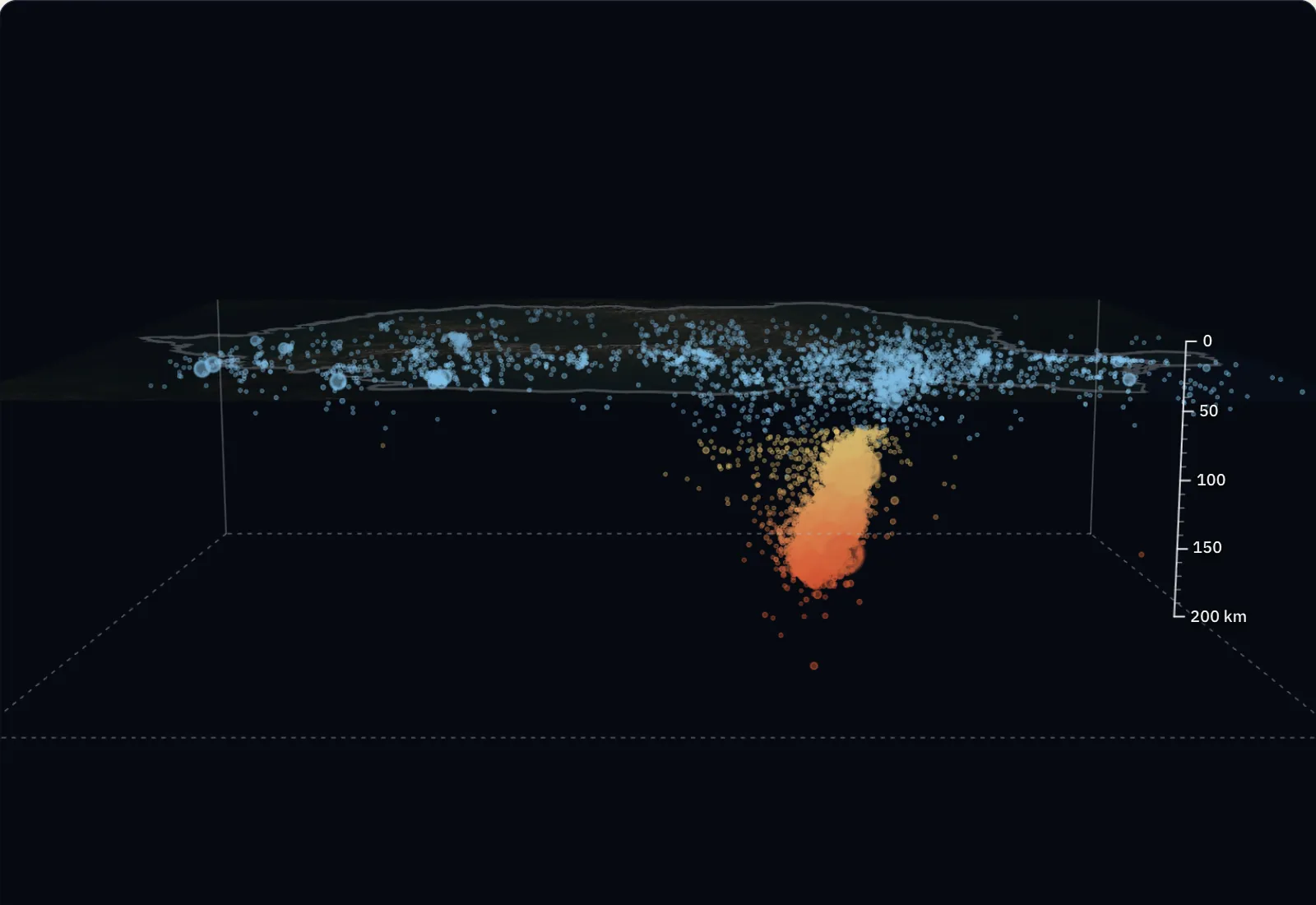
From the side, the Vrancea dots drop far below the others
The relief has turned transparent, and each dot has dropped to the depth of its focus. The ruler measures 200 km, at the same scale as the map. The Carpathians, about 2.5 km high, have become a thin line.
The blue dots, 2,829 of them, stayed near the surface. These are crustal earthquakes, with the focus less than 60 km deep, a depth taken here as the limit of the crust. The other 7,794 dropped below them: these are intermediate-depth earthquakes.
The dotted line joins the focus of the earthquake of 4 March 1977 with its epicentre. The epicentre is the point on the surface above the focus.
Under Vrancea, the foci form an almost vertical column
What remains are the earthquakes under the bend of the Carpathians that started deeper than 60 km: 7,726. Nine in ten have the focus between 73 and 152 km. Seismologists call such a tight group a “nest” of earthquakes.
The two great earthquakes of the last century started here too. The one of 10 November 1940 had a magnitude of 7.7 Mw and a focus at 150 km. The one of 4 March 1977 had 7.4 Mw and a focus at 94 km.
The 1940 earthquake is older than the period drawn; it was added from the same catalogue.
The Vrancea foci lie below the crust, in the mantle
The bands have the average thicknesses from the lesson on the Earth’s internal structure. The continental crust is 30 km thick on average. The lithosphere, the crust together with the rigid part of the mantle, is at least 80 km thick over most of the planet.
The nest begins far below the base of the crust and descends to about 180 km. The rocks that break here are rigid rocks of the mantle. The most widely held explanation: a cold piece of lithosphere, left over from the subduction that ended about 11 million years ago, hangs almost vertically under Vrancea.
The 200 km of the ruler are 3.1% of the way to the centre of the Earth, about 6,370 km down. The bands are a diagram: the real thickness of the crust differs from one region to another.
From 100 km deep, the S wave reaches Bucharest after 39 seconds
A rock breaks at 100 km under Vrancea. From the focus, two wave fronts leave in all directions: the P wave, faster (the thin circle), and the S wave, slower, which usually shakes harder (the thick circle).
To reach Bucharest, the waves travel 177 km, more than the 146 km on the map, because they start from deep down. At average speeds of 8 km/s and 4.5 km/s, the P wave arrives after 22 s, and the S wave after 39 s. At Iași, the S wave arrives after 46 s, at Cluj-Napoca after 62 s.
The speeds are averages; the real time depends on the depth of the focus and on the rocks crossed. The moment and place of a rupture cannot be known in advance.
One magnitude, three intensities
The earthquake of 4 March 1977 had a magnitude of 7.4 Mw. Magnitude shows the energy released at the focus and has a single value for the whole earthquake.
Intensity shows how strongly the earthquake was felt in a place, on the Mercalli scale. In the epicentre zone it reached degree IX. At Focșani, 46 km from the epicentre, it was degree VII, and at Bucharest, 167 km from the epicentre, degree VIII.
The more distant city was hit harder. The focus lay 94 km underground, so both cities were far from it, and the direction in which the rock broke, the soft ground under Bucharest and the tall old buildings counted for more than distance.
Now you explain
On 14 February 2023, in Gorj, in the south-west, an earthquake of magnitude 5.4 Mw started at 13 km depth. On 25 April 2009, in Vrancea, an earthquake of the same magnitude started at 110 km.
Which of them shook the places above the focus harder, and which was felt over a larger area? Explain using the depth and the path the waves have to travel.
Compare with an answer
The magnitude is the same, so the foci released the same energy. In Gorj, the waves had to rise only 13 km to the epicentre: above the focus the intensity is high, but it falls quickly with distance, because at 100 km from the epicentre the wave path is 7.8 times longer. In Vrancea, the waves rose 110 km, so they reached the epicentre weaker; at 100 km from it, the path is only 1.4 times longer. An intermediate-depth earthquake shakes less strongly above the focus, but almost as strongly over a much larger area.
The lesson on earthquakes and volcanoes, with the worked example and questions