Chapter 1 · Geography: the science of terrestrial space
How does a round planet end up on a flat sheet, and what is lost on the way?
Clock: a momentScale: from the globe to the map of a town
The Earth photographed from a satellite carries its grid of parallels and meridians, drawn every 15 degrees. Its curved surface can be stretched onto a plane in several ways, and each way changes something else: the size of countries, their shape, or the route between two cities.
On the classroom map, Greenland looks as big as Africa
This is the world map in the Mercator projection, used on many wall maps and in the map apps on phones. Greenland, at the top, and Africa, in the middle, take up almost the same space on it.
Which of them is bigger in reality?
On the globe, every place has two coordinates
The globe keeps the shape of the Earth, so on it areas, shapes and distances stay in their true proportions. The white lines are the Equator and the Greenwich meridian, from which degrees are counted.
The orange lines are the parallel and the meridian through Bucharest: 44.43° north latitude and 26.11° east longitude. If you chose your town, the lines pass through it.
Drag the globe left or right to turn it.
To become flat, the globe must be cut open and stretched
The globe has been cut open along the 180° meridian and stretched until it is flat. This is the simple cylindrical projection: the parallels and meridians are straight lines and form equal squares.
On the globe, the meridians meet at the poles. Here they stay the same distance apart, so each pole, which is a point, has become a line as long as the Equator. At 60° latitude, everything is drawn twice as wide as in reality.
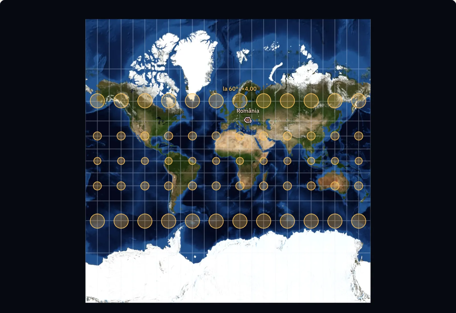
Mercator keeps small shapes and enlarges everything far from the Equator
The yellow circles are the same size on the globe: each has a radius of about 500 km. In the Mercator projection they stay circles, so small shapes are kept. A projection with this property is called conformal.
The area of the circles grows towards the poles, though. At 30° latitude, the circle is drawn 1.33 times as large as at the Equator, and at 60°, 4.00 times as large. At the poles the enlargement would be infinite; that is why the map stops at 85° north and south.
Moved north, Romania grows on the map, though on the ground it stays the same
The red outline is Romania at its true size, 238,397 km². In its own place, the Mercator map draws it 2.06 times as large as it would at the Equator.
Drag the outline or move it with the buttons. At 70° north latitude, where northern Norway lies, the same country takes up 8.72 times as much room on the map as at the Equator.
The drawn area is multiplied by 1/cos² φ, where φ is the latitude. With a button selected, the outline also moves with the arrow keys on the keyboard.
Africa is 14 times larger than Greenland
Greenland has 2.17 million km², and Africa 30.4 million km². Greenland extends between 60° and 84° north latitude, and the Mercator map draws it 16.5 times as large as at the Equator. Africa, which the Equator cuts almost through the middle, is enlarged only 1.11 times.
Brought to the Equator, Greenland is drawn at the same scale as Africa, and you can see how small it is beside it.
An equal-area map keeps areas and changes shapes
This is the Equal Earth projection, published in 2018. It is an equal-area projection: every surface has on the map its real area, reduced to scale. All the yellow circles take the same space here.
Their shape has changed, though. At 60° latitude, the circle has become an ellipse 1.70 times as wide as it is tall, and towards the edges of the map the ellipses also tilt. Greenland now has the correct size, but it is squashed.
The straight line on the map is longer than the shortest route
The dotted blue line joins Bucharest and New York and is straight on the Mercator map. A plane following it would keep the same direction all the way, almost due west, and would fly 8,204 km.
The yellow line is the shortest route on the globe: an arc of a great circle, a circle centred on the centre of the Earth. On the map it looks like a detour to the north, up to 55° latitude, but it measures 7,650 km, which is 554 km less.
Now you explain
A classmate is looking for a world map on which countries have both the right shape and the right size. How do you explain that such a flat map cannot exist?
Compare with an answer
The globe is curved and the map is flat: to lay the globe’s surface flat, it must be cut open and stretched, and stretching changes something. The Mercator projection, which is conformal, keeps the shape of small circles and enlarges their area towards the poles. Equal Earth, which is equal-area, keeps their area and squashes them. Only on the globe do circles have both the right shape and the right size.
Lesson 1.1, on scale and projections · Lesson 1.2, on coordinates