The Black Sea, from the inside
The Black Sea’s oxygenated layer has thinned by more than a third since the 1950s
In 1955–1964, oxygenated water reached, on average, 136 metres down in the open Black Sea. In 2012–2021, the last ten years of the official record, it stopped on average at 88. Below comes a layer with very little oxygen and, beneath it, the world’s largest reservoir of hydrogen sulphide.
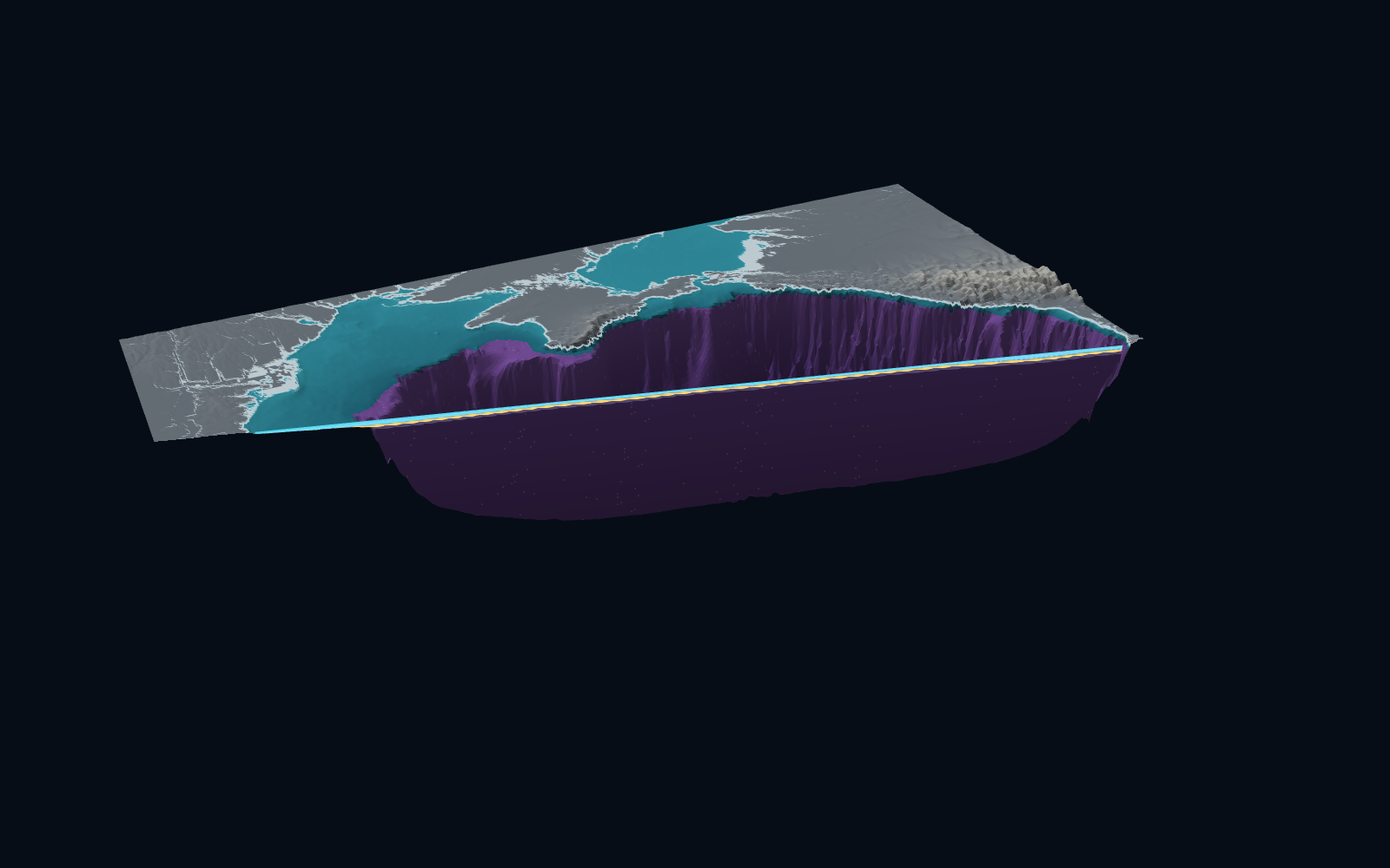
This is the whole sea: its floor, the water with oxygen, and the boundary beneath it, reconstructed from robot floats and the Copernicus physics model up to September 2026. The sea is cut open from Constanța, Romania’s main port, to Batumi in Georgia. You can cut it anywhere yourself.
Click the sea twice to cut it where you like. Right-click and drag to turn it.
#Starting from Constanța
Near the Romanian coast the sea is shallow. On the shelf oxygen can reach the seabed, though seasonal hypoxia also occurs near the bottom in summer. On the line to Batumi the floor only passes 200 metres after 136 kilometres: until then it is the wide shelf off Dobruja and the Danube Delta.
Then the floor drops away and the sea splits in two. Above, water with oxygen. Below, from less than 100 metres down to the floor, water with under 20 micromoles of oxygen per litre, then none.
#Cut open from Constanța to Batumi
The bright band at the top is water with oxygen. The gold line is the oxygen boundary: where oxygen falls below 20 micromoles per litre, under a tenth of what surface water holds. Beneath it, oxygen is almost absent.
In this reconstruction, water above the boundary made up 5.8% of the sea’s volume in 2025: about 31,900 cubic kilometres out of nearly 545,000.
Below the boundary comes the suboxic zone, with very little oxygen and no hydrogen sulphide yet. Further down the sulphide water begins; the depth at which it appears varies from place to place.
Depths are stretched so the layers can be seen: the top 250 metres 550 times, the rest 26 times. At true scale this cut would be 483 times longer than it is deep.
#The boundary is not flat
The gold surface is the oxygen boundary in 2025 across the whole sea. Its lines are every 10 metres, like contours on a hill map. In the middle of the sea it rises: over a tenth of the open sea it is shallower than 67 metres. Towards the edges it sinks: over another tenth it is deeper than 102.
The Black Sea’s layers are domed, higher in the middle and lower at the edges, the shape that goes with the anticlockwise current circling the sea along its coasts. Capet and colleagues, in the study the official record rests on, found the same shape: on average, about 150 metres at the edges and about 80 in the middle.
#The floats that checked the model
Since 2011, 18 Argo robot floats have sunk into the Black Sea and risen again, measuring oxygen, temperature and salinity. Each blue dot is a place where a float found the oxygen boundary: 2,532 clean profiles, up to September 2026. The bright dots are from the chosen year.
The red lines are the boundary according to the Copernicus oxygen model, from its yearly means. The floats’ oxygen was never fed into that model. Matched to them month by month, on 2,377 profiles, the model puts the boundary too deep: a median 8.5 metres too deep, with a typical miss either way of 13.2 metres. A single number per year, the median depth the other floats found, misses by 16.7 on the same profiles. The model’s producer, comparing it another way, finds the opposite: the model’s boundary sits slightly shallower than observations.
The gold surface is built another way. The oxygen boundary sits close to a particular density of water, and the Copernicus physics model reproduces density because it assimilates measured temperatures and salinities. The boundary’s density comes from the floats, year by year. Hide one float at a time and guess its boundary from the others, and it lands, typically, 9.7 metres off on the same profiles. The median error is -0.5 metres, but float by float it ranges from -10.4 to 9.6 metres.
#The boundary has risen over 70 years
The flat blue sheet is the average depth where oxygen ended in 1955–1964, from ship measurements: 136 metres. The gold surface is the boundary in 2025, with its dome shape; part of the gap between them comes from that shape, not from change over time.
In 2012–2021 the average was 88 metres. The oxygen layer has thinned by 48 metres, 35% of its thickness. It did not rise steadily: between 1985 and 1996 it sank again, then rose once more. It was shallowest in 2016: 73.5 metres. If both boundaries were flat, the difference between them would amount to about 15,500 cubic kilometres of water.
The official record stops in 2021. For the years after, the estimates here are provisional and not a validated extension of it: 82 metres in 2022, 84 in 2025 and 76 in January–September 2026 (two floats only). The same method gives on average 84 metres in 2013–2021 and 83 in 2022–2026: after the official years it shows no further rise. The chart shows both lines.
#Water below 8 °C has nearly vanished from the yearly mean
Between the warm water at the top and the salty, heavy water below, the Black Sea has a cold layer, under 8 °C. Winter makes it: wind and frost chill the surface, the cold water sinks onto the heavy layer and stays there. It takes oxygen down with it.
In the cut, deep blue is water under 8 °C in the physics model’s yearly mean. In 1993 this layer was, on average, 79 metres thick in the open sea. Since 2014 it has all but disappeared from the yearly mean, with a brief return in 2017. The minimum temperature in the top 200 metres, in the yearly mean across the open sea, rose from 6.6 °C in 1993 to 8.8 °C in 2024. Press “Play the years” and watch it vanish.
Capet and colleagues write that a warmer atmosphere cut the formation of this layer and with it the ventilation of the water above the boundary, after excess nutrients from rivers had already thinned the oxygenated layer in the 1970s and 80s. Over the 18 years with both series, cold-layer thickness and oxygen-boundary depth decrease together. Year to year, though, the link is weak, so these data alone do not prove the cause.
#Cut the sea where you like
Click the sea in two places and the cut runs between them, or pick a ready-made one. Right-click and drag, or use the arrows in the corner, to turn the sea; it turns back when you scroll on.
#The year you were born
Type your birth year (1955–2021, the years of the official record) to see how deep the oxygen reached then, against the 2012–2021 average.