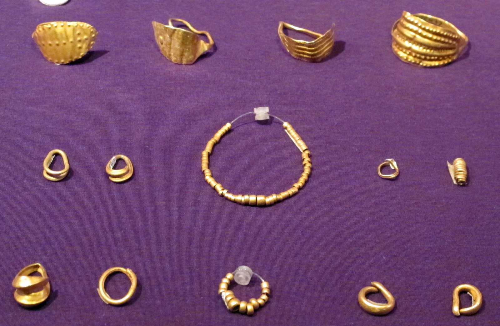
Skip to contentMonteoruGold adornment from the graves at Sărata-Monteoru, Treasury of the National History Museum of Romania. Photo: Sailko, CC BY-SA 3.0, via Wikimedia Commons.
Buzău · Bronze Age
Sărata-Monteoru and the Monteoru culture: eight Bronze Age phases, read on the plan
A Buzău village gave its name to an entire Bronze Age culture. The descent starts on the profile of dealul Cetățuia, drawn from the digs of 1939–1954: eight phases in two periods, one cemetery read grave by grave. At the end: how close the Bronze Age came to your county.
146graves catalogued in cemetery 4, the phase MIIa necropolis, read grave by grave
The Cetățuia section (schematic after Zaharia 1987, fig. 2) · Where the phase's pottery appears · Natural Earth / OSM
The blue pin is your county's capital; the distance runs to the nearest site of the chosen phase.
MIc4 · the beginnings · 3 levels
MIc4 — Everything starts on two terraces
The oldest Monteoru layer lies straight over Cucuteni B, on two Cetățuia terraces. The first two levels (Ic4,1 and Ic4,2) are so far known only here: the village is the culture's only published cradle. Here the cup with saddle-and-threshold handle is born — its signature. On the Poiana Scorușului plateau, large vessels broken in ritual announce a cult place. Its dead are still missing.
Poiana Scorușului, west: the cult place with large vessels (Zaharia 1987).
5 places: Sărata-Monteoru, Năeni, Budureasca and two stone cists in Dâmbovița, attributed to phase Ic4.
MIc3 · second stage · 3 levels
MIc3 — The pyre — and the first great map
At the plateau's edge, a gravel platform 16 by 9 metres, thick with ash and calcined bone: Zaharia read it as the phase's great pyre. The same phase leaves the village: its pottery reaches the Siret and Vrancea — six places with a published phase, the widest phase-dated map the culture ever drew. Where graves appear, cremation appears too.
Poiana Scorușului, west: the 16 × 9 m platform. A pyre, says Zaharia 1990; “another (sacrificial?) function”, suspected Nestor 1960.
6 phase-dated places: from the Siret (Poiana, Răcăciuni) to Vrancea (Cândești).
MIc2 · third stage · 2 levels
MIc2 — The peak of relief
Two levels, relief decoration at its peak: notched ribs, knobs, wide thresholds. The settlement tightens onto the north terraces. The phase-dated map thins to three places; other settlements (Cârlomănești, Pietroasa Mică, Târcov, Tăvădărăști) rest on pottery type, with no phase fixed in the opened publications. The stage report (Zaharia 1991) could not be opened; the text comes from the 1987 scheme and the other sites' reports.
The north and north-east terraces of the Cetățuia.
A single ashy level, with eleven hearths between surfaces K and T. Relief thins out, fine incision returns. The culture's narrow phase: only Cândești and Poiana still show it clearly. At Cândești, inhumations and cremations occupy separate sectors of the same terrace (Florescu 1983).
The high north and north-east terraces: hearths K–T (Zaharia 1993).
3 places: Sărata-Monteoru, Cândești, Poiana.
MIb · fifth stage · thin layer
MIb — The layer that touches Mycenae
Ib is older than Ia — stratigraphy sets the order, not the alphabet. A 5–25 centimetre layer, much ash, huts 2.50 by 2.00 metres. From here comes the antler bit Zaharia set beside Mycenae graves III–V — the only bridge to a Mediterranean date. Wietenberg sherds appear too (Zaharia 1993).
The rectangular huts K–T; the antler bit, Ib level (Zaharia 1993).
3 places, plus one lone cup far off in Valea Răcătăului.
MIa · the awaited stage · cemetery 2
MIa — A hundred graves, a missing chapter
Only now do countable dead appear: cemetery 2, a hundred inhumation graves. Its analysis is promised, not published — the phase reads in the mirror, at Cândești (the south-east group) and Poiana (the north-west group). Amber and glass beads already tie the four cemeteries together, from Ia toward IIb.
The low terraces: cemetery 2 (MIa), 100 graves (Oancea 1981).
2 places: Sărata-Monteoru, Cândești. (Disputed Poiana is not lit here.)
MIIa · second period · cemetery 4
MIIa — One hundred forty-six graves on the north slope
The village fortifies: a defence ditch on the neck tying the Cetățuia to the plateau. The dead move to the north slope, in cemetery 4: 146 graves catalogued one by one (out of 173 excavated), catacomb pits, bodies on bare ground.
The north slope: cemetery 4 (MIIa), 146 catalogued / 173 excavated + the ditch on the neck.
3 places: Sărata-Monteoru, Cândești, Pufești.
MIIb · second period · the Bălintești end
MIIb — The last layer
The last phase on the Cetățuia; its late name, Bălintești, comes from the Bălintești-Cioinagi cemetery, with 38 graves (Zaharia 1963). At home, the phase fills cemeteries 1 (100) and 3; at Cândești, the whole necropolis counts 768 graves (all phases, by the end of 1981) on 12 hectares. Then come the Noua ash mounds. The culture begun on two terraces dies out 55 kilometres to the north-east.
Cemeteries 1 (100) and 3 (count unknown) + the last levels (MIIb).
The whole map hangs off a detail a few centimetres wide: the saddle-and-threshold handle. The Monteoru cup joins its handle to the rim through an arched saddle, and below it a horizontal threshold divides neck from belly. The shape is born in phase Ic4 on the Cetățuia and stays the culture's signature to the end — which is why a sherd from Poiana or Cândești sits on the same scale as the village's layers.
Beyond the cup, the phases' vocabulary is short: the threshold bowl (small, 15–20 centimetres at the mouth, or large, for storage, 35–45), the askos vessel with its crooked neck, the lidded box called a pyxis. Decoration swings between relief (notched ribs, knobs) and fine incision, and its swing is the culture's clock: the peak of relief means Ic2, the return of incision means Ic1.
The dead
Four cemeteries, three phases — and the first dead missing
At Sărata-Monteoru, each late phase buried its dead somewhere else: cemetery 2 is MIa (100 graves), cemetery 4 MIIa (173 excavated, 146 catalogued), cemeteries 1 (100) and 3 (count unknown) MIIb. The funerary ground moved with every phase — natural terraces first, then arranged terraces on the north slope.
Cemetery 4 is the only one read grave by grave: Ligia Bârzu's catalogue runs from T.1 to T.146. The catacomb pits cross the earlier levels; the bodies lie on bare ground. Orientation would give the calendar: 110 graves (75.5%) swing with the sunrise — on Bârzu's hypothesis, the position would tell the season of the funeral.
The catalogue also tells who died young — on anthropological determinations Bârzu calls debatable: 70 children, nearly half the cemetery, 46 under ten; only four people (2.6%) passed 50. A few bodies lie face down — mostly men aged 21–40. The only splendour: glass-paste beads, perhaps sewn onto a shroud (T.142).
The cemeteries of the Monteoru culture — every number with its author
Cemetery
Phase
Graves
Source
SM 2
MIa
100
Oancea 1981
SM 4
MIIa
146 / 173
Bârzu 1989 / Oancea 1981
SM 1
MIIb
100
Oancea 1981
SM 3
MIIb
?
unknown
Cândești
IC3–IIb
768
Florescu 1983
Poiana
Ic3–Ib / IIa
28 / 34
Lie 2019 / Oancea 1981
Pietroasa Mică–Dogaru
MIIb
64
Oancea 1981
Bălintești-Cioinagi
late
38
Zaharia 1963
Căbești
MIIb
11
Oancea 1981
Săbăoani
MIIb
14
Oancea 1981
The figures do not always agree. Cemetery 4: 173 excavated (Oancea 1981), 146 catalogued (Bârzu 1989). Poiana: 34 (Oancea), 28 inhumations (Lie 2019) — after the same 1935–1936 publication; the dating swings between Ic3–Ib (Motzoi-Chicideanu) and IIa (Oancea), so the map lights it only in Ic3–Ib. Cremation in the Moldavian necropolises: about 5% (Zaharia) or about 10% (Nestor), after Oancea 1981. At Cândești, continuity is total: 768 graves in all, counted by Florescu by 1981 (over 800 per Bârzu), from IC3 to IIb.
The other late cemeteries: Dogaru, 64 (62 inhumation burials, 2 cremation burials); Bălintești-Cioinagi, 38; Căbești, 11; Săbăoani, 14. The early phases (Ic4–Ib) have no discovered necropolis yet at Sărata-Monteoru.
And the pyre is the site's most disputed square metre: 16 by 9 metres of gravel, ash and calcined bone. Zaharia: an Ic3 cremation pyre. Nestor, already in 1960: the pyre was never fully researched, and the absence of urn graves points to “another (sacrificial?) function”. Motzoi-Chicideanu: insufficient documentation, controversy to this day. Both labels stay on the same figure.
Grave goods say how far the living looked. The Berlin museum's Monteoru collection holds six triangular and five round plaques, in bone, pierced at the centre (Zaharia 1993). Separately, helmet plaques of boar tusk belong to the same late horizon (Oancea 1981). And the amber and glass beads, present in all four cemeteries between phases Ia and IIb, tie the hill to roads whose ends cannot be seen from the village.
One last map of the dead is a map of archives: the Honzik collection went to Berlin; part returned after 1918. To see the whole necropolis you need two museums in two countries. The gold adornment is in Bucharest, in the National History Museum's Treasury.
Time
Eight phases, two periods — and three anchors
The scheme used here is Eugenia Zaharia's, read off the Cetățuia stratigraphy: period I (MIc4 → MIc3 → MIc2 → MIc1 → MIb → MIa), period II (MIIa → MIIb). Levels are counted only where she counted them: 3+3+2+1. The rest are ceramic phases, not storeys.
There is a rival scheme: Marilena Florescu (1966) divides the culture into three periods, with Ic1 already in the third. Zaharia's scheme stays in use here — because the plans and sections are hers.
Zaharia's scheme, read off the Cetățuia stratigraphy
Phase
Period
Levels
Marker
MIc4
I
3
the cradle · saddle-and-threshold
MIc3
I
3
the pyre · the great map
MIc2
I
2
peak of relief
MIc1
I
1
11 hearths
MIb
I
—
the Mycenae layer
MIa
I
—
cemetery 2 (forthcoming)
MIIa
II
—
cemetery 4 · the ditch
MIIb
II
—
the Bălintești end
No calendar dates per phase exist in the opened literature, so no single timeline bar appears. Instead, three anchors, each with its author. First: Zaharia sets the MIb level and its antler bit beside Mycenae graves III–V, Circle A — usually dated circa 1600–1500 BC (after Dartmouth's Aegean prehistory synthesis). An inference, not a laboratory date.
Second: the Cândești team dates the necropolis between 1550 and 1300 BC (Groza and collaborators, 2020). Third: the museum label of the Sărata-Monteoru adornment says the 16th–14th centuries BC. Three voices, three methods — all point to the mid-2nd millennium BC for the late phases. From the eponymous site itself, no radiocarbon series has appeared in the opened literature.
The dig
A hundred years of digging, two wars
It starts with the spa: around 1900, building work turns up sherds, and the German engineer Eduard Honzik gathers a collection that ends up in Berlin. Hubert Schmidt takes note, publishes the first notice in 1907 and digs in 1917–1918, on the Cetățuia and in the cemeteries later numbered 1 and 2. He first publishes the station — but the results stay unpublished.
In 1926–1927 the National Museum of Antiquities resumes digging under Ioan Andrieșescu and the young Ion Nestor. Cemetery 4 yields its first graves; one cup survives. The material goes to the Faculty of Letters, unpublished; part is lost in the bombing of 4 April 1944.
From 1937 the dig is Nestor's, until 1958: the Cetățuia and cemeteries 1–2, the neck with the ditch (1945, 1952), the plateau (1952, 1954). The bulk of cemetery 4 comes to light in 1949–1952. The last campaigns, 1955–1958, go to the 6th–7th-century AD necropolis — three millennia younger.
The name “Monteoru culture” is fixed by Nestor in his 1933 synthesis. Eugenia Zaharia publishes the stratigraphy in the Dacia series, 1987–1993: the beginnings, stages II and III, stages IV–V. Stage MIa, with cemetery 2, remains the promise in the last footnote.
Method
What is a new drawing and what is not known
The section, the site plan and the map are new schematics, drawn after the published figures (Zaharia 1987, figs. 1–2; Zaharia 1993, fig. 1; Bârzu 1989, fig. 1; Oancea 1981, fig. 1) and today's village coordinates. Site positions are village-level — the exact findspot of most is not published with coordinates. Cândești is the exception: its coordinates come from the National Archaeological Repertory, via Groza 2020. The hamlet of Cioinagi (Bălintești) could not be located on current maps — it appears in the text, not on the map.
Three things are not known and are not filled with guesses: the grave count of cemetery 3 at Sărata-Monteoru, calendar dates per phase, and the stage-III report (Zaharia 1991), still unopened. The salt spring belongs here too: salt reaches the surface at Sărata-Monteoru (published geology), but no spring on the site and no link to the settlement could be verified — the lead is dropped, not hinted.
Visit
Three stops and a question
You can see the adornment in Bucharest, in the National History Museum's Treasury. Dealul Cetățuia (283 m, after Zaharia 1987) climbs from Sărata-Monteoru village, Merei commune; the Cândești terrace shows from toward Dumbrăveni. And one question for a Buzău grandparent: which did they hear of first — the “cetățuia” above the village, or the Monteoru culture? The village is documented since 1507.