THE FIGURE
The mountain's figure
OSM says 3776.2; the essay says 3,776 m. M01 M02 M16
Wikipedia says 3,776.24 m, OpenStreetMap 3776.2, and nippon.com — 3,776 m, the country's tallest peak. The essay keeps 3,776 m throughout. M01 M02 M16

Visual essay · eight chapters · 3,776 m
3,776 m of active volcano, four ticketed trails, one sealed eruption in 1707–08 and five lakes at its foot — eight chapters on Japan's sacred mountain. M01 M02 M05 M09 M12
On 16 December 1707, the mountain's south-eastern flank split open: the Hōei eruption would run until 24 February 1708 and sift ash all the way over Edo. M05 M06
Chapter 1 · One figure, one volcano
Mount Fuji is an active stratovolcano on the island of Honshu, topped at 3,776 m — Japan's highest mountain and the second-highest volcano on any Asian island. M01 M02 M16
The mountain straddles the boundary of Shizuoka and Yamanashi prefectures inside Fuji-Hakone-Izu National Park, about 100 km south-west of Tokyo. M01 M03
An active 3,776 m volcano that has not erupted since 1707 — yet nobody calls it extinct. M01 M05 M06
THE FIGURE
OSM says 3776.2; the essay says 3,776 m. M01 M02 M16
Wikipedia says 3,776.24 m, OpenStreetMap 3776.2, and nippon.com — 3,776 m, the country's tallest peak. The essay keeps 3,776 m throughout. M01 M02 M16
THE BORDER
Fuji-Hakone-Izu; ~100 km SW of Tokyo. M01 M03
Fuji straddles the Shizuoka–Yamanashi boundary inside Fuji-Hakone-Izu National Park, about 100 km south-west of Tokyo — close enough to see from the city on clear days. M01 M03
THE CROWN
Node 873531353: peak, 3776.2. M16 M01
The mountain's highest point is Kengamine (剣ヶ峰), on the crater rim — node 873531353, at the same 3776.2 mark. M16 M01
THE RIM
The rim walks on foot, in summer. M04
The crater rim walks on foot: the Ohachimeguri rim trail is open in season, when all four roads climb toward the top. M04
Image gallery

Chapter 2 · The living engine
Mount Fuji's last confirmed eruption began on 16 December 1707 and ended on 24 February 1708 — the Hōei eruption, named for the fourth year of the Hōei era, at VEI 5. M05 M06
The eruption opened Mount Hoei and new craters on the south-eastern flank, threw ash as far as Edo, 95 km to the north-east, and brought landslides and starvation across the country. M05 M06
Three unconfirmed eruptions between 1708 and 1854 — but the last sealed one stays Hōei, of the winter of 1707–08. M05
THE DATES
Hōei year 4; three unconfirmed since. M05
The Hōei eruption ran from 16 December 1707 to 24 February 1708 and is the last confirmed one: three later reports, between 1708 and 1854, were never sealed. M05
THE CONE
Node 599156790; the crater is visitable. M05 M06 M16
The eruption raised Mount Hoei (宝永山, node 599156790) and the craters on the south-eastern flank — the main crater is visitable today from the Fujinomiya and Gotemba trails. M05 M06 M16
THE ASH
Landslides, starvation; 49 days after the quake. M05 M06
Ash fell over Edo, 95 km to the north-east, followed by landslides and starvation. The eruption broke out 49 days after the great offshore earthquake. M05 M06
THE STRATA
Enryaku 800–802 · Jōgan 864–866. M02
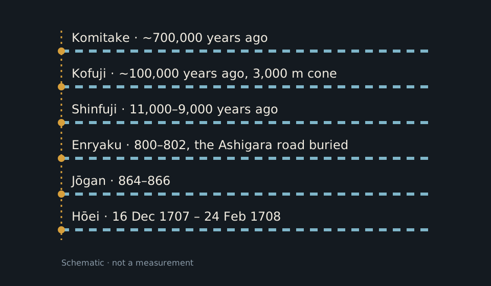
Under Hōei lie the strata: Komitake from ~700,000 years ago, Kofuji from ~100,000 years ago with its 3,000 m cone, the Shinfuji phase from 11,000–9,000 years ago — then the historic Enryaku (800–802), when ash buried the Ashigara road, and Jōgan (864–866) eruptions. M02
Chapter 3 · Belief
In 2013, at the 37th session of the World Heritage Committee, Fuji joined the UNESCO list as a cultural property: “Fujisan, sacred place and source of artistic inspiration”, file 1418, criteria iii and vi. M07 M01
The site covers 20,702.1 ha with a 49,627.7 ha buffer zone — and pilgrimages have climbed the mountain for centuries along the sacred routes charted by the heritage council. M01 M07
An altar on the top, a goddess of the mountain, and two religions kneeling on the same slope. M14 M07
THE SEAL
20,702.1 ha + 49,627.7 ha buffer. M01 M07
File 1418, cultural criteria iii and vi: 20,702.1 ha of site and 49,627.7 ha of buffer zone, sealed in 2013 at the 37th session. M01 M07
THE FIRST
The ascetic monk, per the infobox. M01
The first recorded ascent is from 663, by En no Ozunu (En no Gyōja) — more than a millennium before the mountain earned its UNESCO seal. M01
THE ALTAR
Konohanasakuya-hime; pilgrimage routes. M14 M07 M01
A Sengen shrine to the goddess Konohanasakuya-hime stands on the summit, and pilgrimage routes have climbed the mountain for centuries, for Shinto and Buddhist pilgrims. M14 M07 M01
Image gallery
Chapter 4 · The image
Hokusai's “South Wind, Clear Sky” — Red Fuji —, first published c.1830 in the Thirty-six Views of Mount Fuji series, is the mountain reduced to a single red triangle under the morning sky. M25 M05
Hokusai returned to Fuji a hundred times: the One Hundred Views series holds the small crater at a secondary eruption site too — the mountain as muse, as the UNESCO title also names it. M05 M07
Sacred place and source of artistic inspiration — the file 1418 title tells the whole chapter in advance. M07
THE RED
Hokusai; public domain, PD-Art. M25
“South Wind, Clear Sky” — Red Fuji —, first published c.1830 in Thirty-six Views of Mount Fuji: a heritage plate, public domain, under the PD-Art seal. M25
THE HUNDRED
The small crater, drawn by Hokusai. M05
In One Hundred Views of Mount Fuji, Hokusai also draws the small crater at a secondary eruption site — the volcano as the artist saw it. M05
THE MUSE
File 1418: art, not just rock. M07 M01
The UNESCO file title — “source of artistic inspiration” — makes art half the file: Fuji is heritage for what it gave artists too, not just for its rock. M07 M01
Image gallery

Chapter 5 · The four roads
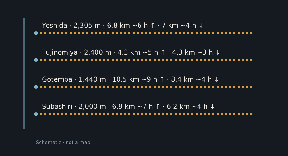
Four trails climb Fuji, each from its own 5th station: Yoshida from 2,305 m (6.8 km up in ~6 hours, 7 km down in ~4), Fujinomiya from 2,400 m (4.3 km in ~5 hours up, 4.3 km in ~3 down), Gotemba from 1,440 m (10.5 km in ~9 hours, 8.4 km in ~4) and Subashiri from 2,000 m (6.9 km in ~7 hours, 6.2 km in ~4). M08
The season runs from 1 July (Yoshida and Subashiri) and 10 July (Fujinomiya and Gotemba) to 10 September, when everything closes; outside it, all trails are shut and climbing is “extremely dangerous”. M04 M09
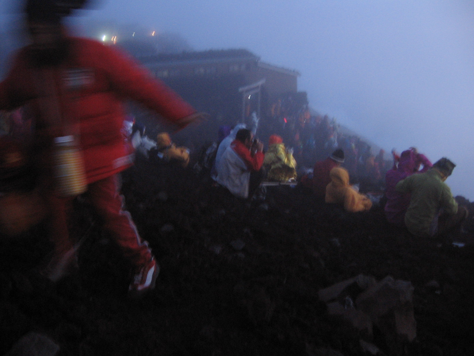
The classic climb is the night one, for sunrise: dawn caught on the summit, between 4:30 and 5:00. M09
THE FOUR
2,305 · 2,400 · 1,440 · 2,000 m starts. M08 M16
Yoshida (2,305 m), Fujinomiya (2,400 m, the shortest and highest-starting), Gotemba (1,440 m, the longest: 10.5 km up) and Subashiri (2,000 m — the official figure, not the OSM 1970 tag). M08 M16
THE SEASON
Everything closes on 10 September. M04 M09
Yoshida and Subashiri open on 1 July, Fujinomiya and Gotemba on 10 July; on 10 September everything closes. Off-season, climbing is “extremely dangerous”. M04 M09
THE SUNRISE
Nights on the mountain, dawn on the top. M09 M20
In summer the sun rises between 4:30 and 5:00 am, and the classic climb is the night one, to catch dawn on the summit. M09 M20
THE FOREIGNER
The first foreigner on top: Rutherford Alcock. M01
The first foreigner to climb the mountain was Sir Rutherford Alcock, in September 1860: 8 hours up, 3 hours down. M01
Image gallery


Chapter 6 · The ticket
Since 2025, all four trails carry a ¥4,000 ticket with online reservation and a QR-code permit; since 2026, Yoshida added the 4,000-a-day cap, gates shut between 2 pm and 3 am, and the mandatory gear check. M09
The Environment Ministry counted 221,322 climbers in 2023 and 204,316 in 2024, with a preliminary ~245,000 for 2025 — yet the sunrise rush still crowds the summit dangerously. M14 M15
At the Chureito pagoda, the alert reads overtourism: crowding, noise, litter and trespassing. M10
THE TICKET
Online reservation, QR-code permit. M09
¥4,000 per person on all four trails, with advance online reservation and payment: from 2024 on Yoshida only (¥2,000 then), from 2025 everywhere. M09
THE GATE
Boots, warm layers, rainwear — or down. M09
Gates shut between 2 pm and 3 am against bullet climbs, the 4,000/day Yoshida cap stays (unhit in 2024–2025), and without boots, warm layers and rainwear you are turned back. M09
THE COUNT
2023: 221,322 · 2025: ~245,000 preliminary. M14 M15
221,322 in 2023, 204,316 in 2024 (−8%), ~245,000 preliminary in 2025 — the Environment Ministry figures via the press, from infrared counters on the four trails. M14 M15
THE CROWD
Plus the Chureito alert: noise, litter. M15 M10
The sunrise rush still packs the summit dangerously despite the rules — and at the Chureito pagoda the official alert names crowding, noise, litter, traffic and trespassing. M15 M10
Chapter 7 · The foothills
At the mountain's northern foot, in Yamanashi prefecture, lie the Fuji Five Lakes — Kawaguchi, Yamanaka, Sai, Shōji and Motosu — at about 1,000 m altitude, in a region of some 100,000 people. M12 M11
The five lakes are the work of the mountain's past eruptions. M12 M16
Five lakes, a single father: the volcano. M12
FIVE
Made by past eruptions. Full stop. M12 M11
Five lakes at about 1,000 m altitude, at the northern foot: Kawaguchi, Yamanaka, Sai, Shōji and Motosu — made by the mountain's past eruptions. M12 M11
THE TOWNS
~100,000 people in the whole region. M12
The region's principal town is Fujiyoshida, with roughly 54,000 people, in a region of about 100,000. M12
THE PINS
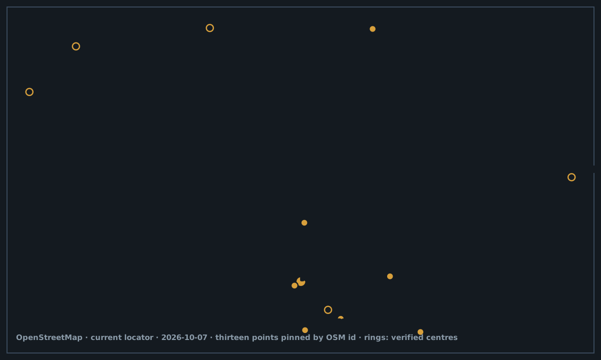
243818922 · 9440752 · 9440754 · 2313177 · 9440753. M16
On the map: Kawaguchiko is node 243818922, and Yamanakako, Motosuko, Shojiko and Saiko are relations 9440752, 9440754, 2313177 and 9440753. M16
Chapter 8 · The watch
Fuji is on the Japan Meteorological Agency's watched-volcano list, and NASA puts it dryly: the volcano is “considered active”. Steam was last seen on the top between 1780 and 1820. M13 M06
The staffed summit weather station closed in September 2004 after 72 years — Japan's highest, at 3,780 m, with typhoon radar. Snow holds about five months a year. M01
No eruption since 1708 — but a sleeping volcano is not an extinct one. M06 M05
THE WATCH
Steam on the top: 1780–1820. M13 M06
The weather agency keeps it on the monitored-volcano list, NASA calls it “considered active”, and steam was last seen on the top between 1780 and 1820. M13 M06
THE STATION
Japan's highest station. M01
The staffed summit weather station closed in September 2004 after 72 years: Japan's highest, at 3,780 m, with radar that caught typhoons. M01
THE SNOW
The March 2025 sunset: still white. M01 M26
The cone sits under snow about five months a year — and the March 2025 sunset caught it still white. M01 M26
Image gallery

Sources and limits
Annotations retain the status in the source ledger.
Tertiary encyclopedia · official-link-unverified
Data journalism · official-link-unverified
State environment ministry · official-link-unverified
Official climb operator · official-link-unverified
Tertiary encyclopedia · official-link-unverified
Space agency observatory · official-link-unverified
https://science.nasa.gov/earth/earth-observatory/mount-fuji-japan-39099/
Heritage council · official-link-unverified
Official climb operator · official-link-unverified
Commercial guide + prefecture notice · official-link-unverified
https://www.japan-guide.com/e/e6901.html · https://www.fujisan-climb.jp/wp-content/uploads/2026/03/Yamanashi_Notice_MtFuji2026JP_EN.pdf
Commercial guide · official-link-unverified
Commercial guide · official-link-unverified
Tertiary encyclopedia · official-link-unverified
State weather agency · official-link-unverified
https://www.data.jma.go.jp/vois/data/report/activity_info/314.html
Press relay of ministry figures · official-link-unverified
Press relay of ministry figures · official-link-unverified
OpenStreetMap records · official-link-unverified
https://www.openstreetmap.org/node/714354378 · https://www.openstreetmap.org/node/873531353 · https://www.openstreetmap.org/node/599156790 · https://www.openstreetmap.org/way/261641628 · https://www.openstreetmap.org/node/472549661 · https://www.openstreetmap.org/node/4265465389 · https://www.openstreetmap.org/node/3042913544 · https://www.openstreetmap.org/node/9122255504 · https://www.openstreetmap.org/node/243818922 · https://www.openstreetmap.org/relation/9440752 · https://www.openstreetmap.org/relation/9440754 · https://www.openstreetmap.org/relation/2313177 · https://www.openstreetmap.org/relation/9440753
Commons original · official-link-unverified
Commons original · official-link-unverified
https://commons.wikimedia.org/wiki/File:Hoei_Crater_s4_-_cropped.jpg
Commons original · official-link-unverified
https://commons.wikimedia.org/wiki/File:ISS-46_Mount_Fuji,_Japan.jpg
Commons original · official-link-unverified
https://commons.wikimedia.org/wiki/File:August_2009,_sunrise_seen_from_top_of_Mount_Fuji_-49950.jpeg
Commons original · official-link-unverified
https://commons.wikimedia.org/wiki/File:August_2009,_top_of_Mount_Fuji_at_night.jpg
Commons original · official-link-unverified
https://commons.wikimedia.org/wiki/File:Fuji_Subaru_Line_5th_Station,_Mount_Fuji_(42361757730).jpg
Commons original · official-link-unverified
https://commons.wikimedia.org/wiki/File:Lake_Yamanaka_and_Mount_Fuji.JPG
Commons original · official-link-unverified
https://commons.wikimedia.org/wiki/File:Lake_Kawaguchiko_Sakura_Mount_Fuji_4.JPG
Commons original · official-link-unverified
https://commons.wikimedia.org/wiki/File:Red_Fuji_southern_wind_clear_morning.jpg
Commons original · official-link-unverified
https://commons.wikimedia.org/wiki/File:Mount_Fuji_at_sunset,_March_2025.jpg



.jpg)


