The whole bridge, in words
The ten stops, in order. Each says how it is known.
Four ways of knowing
- Measured or excavatedpiers, arches, starlings; in stone
- From records and engravingsthe houses, the chapel, the gate; plain plaster
- Assumeddetail, people, boats, the banks; ink drawing
- A witness or a traditionwhat someone who saw it wrote, or what was told
1 From records and engravings
A bridge with a town on it
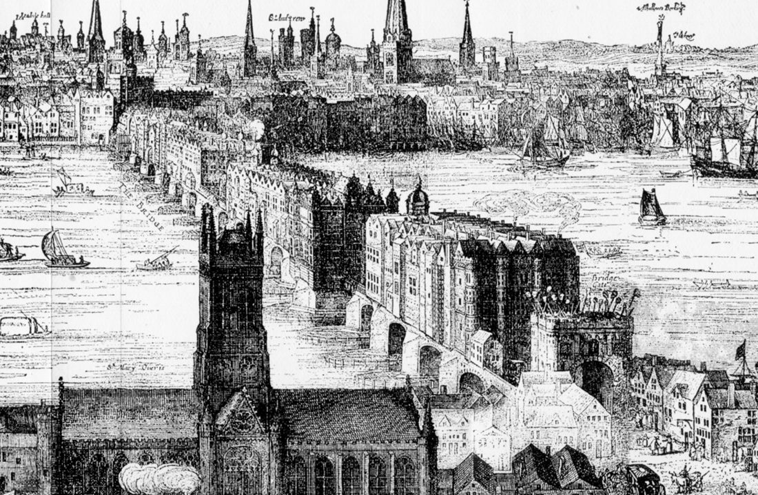

The stone bridge stood over the Thames for more than 600 years, from 1209 to 1831, and until Putney Bridge opened in 1729 it was the only road crossing of the river below Kingston. It was 926 feet long, about 282 metres, on 19 arches and one opening with a drawbridge. For some 550 years houses of up to six storeys stood along it, wall to wall, with a narrow street down the middle. A German traveller, Paul Hentzner, wrote in 1598 that it looked like a continuous street, “not at all of a Bridge”.
The picture is a December morning around 1600, seen from a boat below the bridge halfway through the ebb. The lower handle lowers and raises the water. The other shows how each thing is known: stone is what was measured, plain plaster is what the records and the engravings imply, ink drawing is what is assumed.
2 Measured or excavated
The starlings: piers that squeezed the river
Each pier was enclosed by a starling, a platform pointed at both ends: a pen of piles driven into the bed round it and filled with broken stone. Every repair made it bigger. In 1736 the architect Nicholas Hawksmoor measured that at low water only 194 of the river's nearly 900 feet were left open, “not a quarter of the whole”.
Full ebb: the platforms are out of the water. Their size in the picture is worked back from Hawksmoor's total. On 14 August 1821 an engineer, Mr Knight, dug beside a pier and found the base of the original masonry 2 feet 3 inches above low water, laid on an oak sill, over a heap of Kentish rubble mixed with flint and chalk, thrown in without mortar. There were no piles under the original work.
Sources
- Richard Thomson, Chronicles of London Bridge (1827), Internet Archive scan
- John Britton, A. Pugin, W. H. Leeds, “London Bridge”, Illustrations of the Public Buildings of London (1838), thames.me.uk transcription
- Chris Catling, “Life across the water”, Current Archaeology 391 (2022), on Dorian Gerhold's book
3 A witness or a tradition
“Made for wise men to go over”
With the river squeezed between the starlings, on the ebb the water above the bridge stood higher than the water below. In the 1740s the engineer Charles Labelye recorded a fall of “nearly five feet” for the greater part of every tide, about a metre and a half; Thomson wrote in 1827 that at low water it was 4 feet 6 inches, and 6 feet in winter. A waterfall ran through every opening.
Watermen still took their boats through it; the writer Ned Ward, in 1700, heard a “frightful roaring”. The proverb collected by John Ray said the bridge was made for wise men to go over and fools to go under. The fall in the picture is the one in the sources; the shape of the waves is illustration.
4 Assumed
The wheel that sent water over a steeple
The fall was also a source of power. A Dutchman settled in London, Peter Morice, set a wheel in the first arch from the City end. Thames water went through lead pipes over the steeple of St Magnus, the church at the north end of the bridge, to houses in Thames Street, New Fish Street and “Grasse-street” (now Gracechurch Street); on Christmas Eve 1582 it first ran at the corner of Leadenhall, the highest ground in the City.
Rebuilt several times, the wheels worked for nearly 240 years. Nobody describes what the first one looked like, so it is drawn in ink, and its exact place in the arch is assumed. For it to fit, the starlings in the first arch are also assumed narrower.
5 From records and engravings
The street above the river
Before it was widened in the 1680s, the street on the bridge was 14 to 16 feet wide, about 4.5 metres; in a survey of 1683, from 12 feet 5 inches under Nonsuch House to 18 feet 5 inches at the Southwark end. It was the road between the City and Southwark.
The historian Dorian Gerhold has reconstructed the plots from the bridge's rent records, house by house: plots about 10 feet wide, houses up to 34 feet deep, the shop on the street, the back hanging over the water on beams braced from the piers. Roughly every other house shared a room across the street with the house opposite, starting about 10 feet up. About 500 people lived on the bridge, and the rents brought in about a quarter of its income.
6 Measured or excavated
The chapel on the great pier
The middle pier was the largest: 35 feet broad and 115 from point to point. On it, on the east side, stood the chapel of St Thomas Becket, 60 feet long and 20 wide. Its west front, on the street, was 40 feet high, with a gable and a cross, and below the chapel was a second room at water level.
After the Reformation, in the mid-16th century (1549 or 1553, depending on the source), the chapel became a house. Its stone is what was drawn before demolition; the windows in ink follow the engravings.
7 From records and engravings
Nonsuch House, the house “without equal”
In 1577–1579 the drawbridge tower was replaced by Nonsuch House: according to Dorian Gerhold, about 75 by 25 feet, four and a half storeys, with a tower at each corner crowned by a short dome. The street ran beneath it.
Thomson wrote in 1827 that it had been made in Holland, of wood, brought over in pieces and put up with wooden pegs only, not a single iron nail. Gerhold gives it an English designer, Lewis Stockett, Surveyor of the Queen's Works; the Dutch story remains a tradition. The domes are drawn: Thomson describes them and the engravings show them, but their exact form is not known.
8 A witness or a tradition
The stone gate and the heads
Towards Southwark, on the 18th pier from the north, the street passed under a stone gate. On it, on iron spikes, were the heads of people executed for treason. Until 1577 they had stood on the drawbridge tower; then they were moved here.
Hentzner, in 1598: “we counted above thirty”. The poles in the picture are 31, the smallest number his “above thirty” allows, drawn in ink. Their placing is assumed.
9 Measured or excavated
1761: the houses go, the waterfall stays
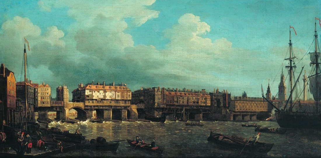

An Act of 1756 let the City buy every house in order to pull it down. The last tenant left in 1761, after some 550 years of houses on the bridge. The street was widened to 46 feet, with a stone balustrade and 14 alcoves for people on foot.
In 1759, to let ships through, the two middle arches were replaced by a single one, the Great Arch, of 70 feet: the chapel pier was taken out. But the other arches and the starlings stayed, and with them the fall. The Great Arch weakened the rest of the bridge, and repairs cost more and more.
10 Measured or excavated
1831: the new bridge, 30 metres upstream
John Rennie's bridge, five wide granite arches, was built 100 feet, 30 metres, upstream. It opened on 1 August 1831, and the old bridge was pulled down afterwards. Without the starlings the river ran faster and freer; the last frost fair on the frozen Thames had been held in 1814.
Rennie's bridge was sold in 1968 to an American businessman and rebuilt at Lake Havasu City, Arizona. Little of the medieval bridge survives; St Magnus church to the north and Southwark Cathedral to the south still mark where it landed.
Sources

How exact the reconstruction is
Arch and pier widths come from Hawksmoor's and Vertue's ground plan, reproduced by Richard Thomson in 1827 (pp. 60–61), measured from the City end; the two abutments take the difference up to 926 feet. The arches are pointed, all of the same shape; the height of each is not in the plan and is chosen after the engravings.
Water levels: full ebb is zero; a spring tide rose 14½ to 15 feet above bridge, and its mark stood 8½ feet over the starlings and 7½ over the springing of the arches (Thomson, p. 400). The greatest fall at low water is 5 feet, after Labelye. Between high and low water the fall is modelled, not measured; the flood, when the water runs the other way, is not shown.
The size of the starlings is computed: the same projection on every side, chosen so that the openings left at low water add up to 194 feet, Hawksmoor's figure of 1736. Around 1600 they were probably a little smaller. Their boat shape follows the 18th-century views.
The houses: 10-foot plots, depths up to 34 feet, a 15-foot street, rooms over the street from 10 feet up and the number of storeys (four or five, sometimes three or six) come from Dorian Gerhold's study, as cited in reviews. Which plot has which house, the height of each and the colour of the plaster are not documented; they vary within those limits. The gaps between the rows follow the views of Visscher (1616) and Hollar (1647).
The banks and the town are a setting drawn in ink, not a reconstruction. St Magnus and St Mary Overie, St Paul's without the spire lost in 1561, and the Tower of London are placed approximately. The boats, the people in the street, the wheel and the heads on the gate are assumed.
The light is that of 16 December at about 10:30 in the morning, the sun some 13 degrees above the horizon, a little east of south. The mist on the water is chosen.
Sources
Most figures come from Richard Thomson's chronicle of 1827, which reproduces the plan measured by Hawksmoor and Vertue, and from Dorian Gerhold's house-by-house study (2019), as cited in reviews.
- Richard Thomson, Chronicles of London Bridge (1827), Internet Archive scan
- Dorian Gerhold, “London Bridge”, Country Life
- Wikipedia, London Bridge (sections on the medieval bridge and Rennie's bridge)
- John Britton, A. Pugin, W. H. Leeds, “London Bridge”, Illustrations of the Public Buildings of London (1838), thames.me.uk transcription
- Chris Catling, “Life across the water”, Current Archaeology 391 (2022), on Dorian Gerhold's book
- Designing Buildings: review of London Bridge and its Houses, c.1209–1761 (Dorian Gerhold, London Topographical Society, 2019)
- Samuel Scott, Old London Bridge, c. 1757 (Wikimedia Commons, public domain)
- The frozen Thames, 1608–1814 (same series)
- Edward William Cooke, The Southwark End of Old London Bridge, 1831 (Yale Center for British Art, CC0)
- Claes Jansz. Visscher, panorama of London, 1616 (Wikimedia Commons, public domain)
- Wenceslaus Hollar, Long View of London from Bankside, 1647 (Wikimedia Commons, public domain)
