WARSAW · POLAND · 1944–1980
Warsaw’s Old Town: paintings and measured records
Canaletto preserved views of old Warsaw. Reconstruction after 1944 also used plans, surveys, surviving buildings and archives.
01 / 06
What can a painting establish? #
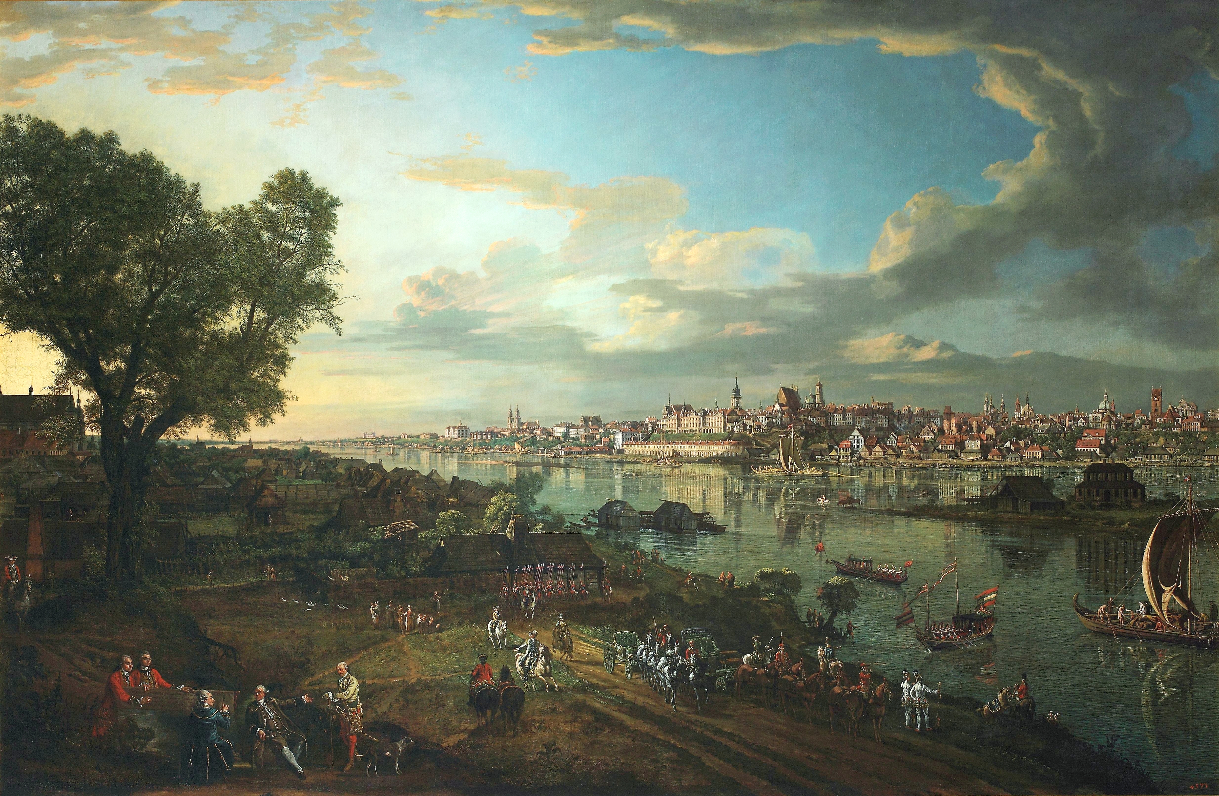
Credit: Bernardo Bellotto · 1770 · Public domain · PD-Art · PD-old-100-1923 · Open the file record · Licence Public domain · PD-Art · PD-old-100-1923

View of Warsaw from Praga, painted by Bernardo Bellotto in 1770, looks towards the city from the Praga district. It records one moment through a painter’s view. Plans, elevations and surveys answer questions about building geometry and structure.[V12] [V05]
Bellotto, also known as Canaletto, made a series of 22 views of Warsaw and its surroundings, commissioned by Stanisław August and painted between 1767 and 1780, according to the Royal Castle in Warsaw. William A. Singleton’s 1959 account lists Canaletto among the many sources used in reconstruction, alongside technical records.[V12] [V05]
This panorama is a valuable visual record and one source among several. Decisions about dimensions, structure and interventions also needed technical records, surviving buildings and research on site.[V01] [V02] [V05]
02 / 06
What remained after the 1944 destruction? #
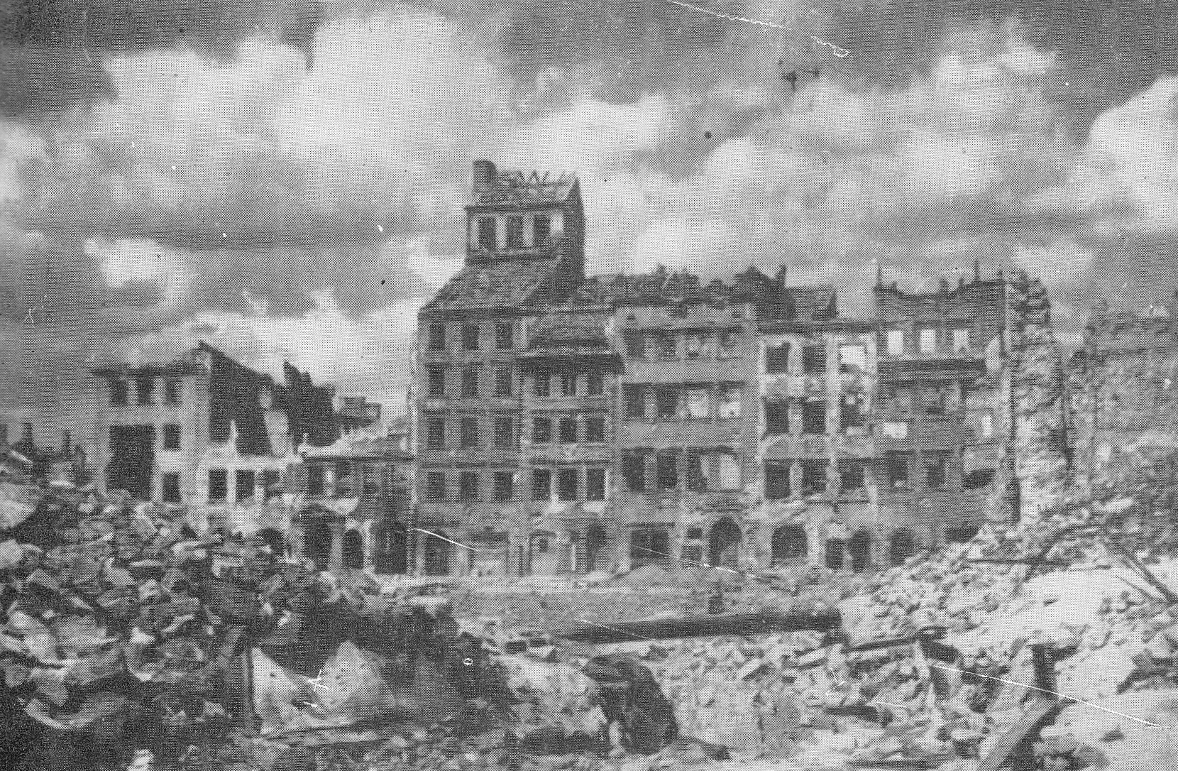
Credit: M. Chrząszczowa · 1945 · Public domain · PD-Polish (PD-Poland rationale) · Open the file record · Licence Public domain · PD-Polish (PD-Poland rationale)

After the 1944 Warsaw Uprising, German forces deliberately destroyed Warsaw’s historic centre. The 1944 Warsaw Uprising is a separate event from the 1943 Warsaw Ghetto Uprising.[V01] [V04] [V06]
The 1945 photograph records Dekert’s Side of the Old Town Market Square. It documents one frontage, not the uniform condition of every building or the whole city. The Museum of Warsaw notes that parts of some houses on this side survived and that rubble inventory in the Old Town began in March 1945.[V08]
The Warsaw Reconstruction Office (Biuro Odbudowy Stolicy, BOS) was founded on 14 February 1945. Its archive holds photographs, drawings, plans, correspondence and technical records dated 1945–1953.[V03] [V04]
03 / 06
What made up the reconstruction record? #
In his contemporary 1959 account, Singleton says pre-war architectural studies yielded plans, sections, elevations and details that formed the basic technical record. Historical paintings were used alongside them.[V05]
UNESCO’s accounts describe the use of buildings that survived, archival documentation, inventories from before 1939 and after 1944, photographs and late-eighteenth-century images. Jerzy Elżanowski and Carmen M. Enss’s study adds BOS field-survey sheets, block and damage maps, and archaeological records.[V01] [V02] [V06]
Each kind of evidence answers a different question. Surveys preserve recorded geometry; inventories and photographs document observed conditions; paintings offer historical depictions. Together, these records informed conservation and design decisions.[V01] [V02] [V05] [V06]
- 01
- 02
- 03
- 04
The bands name evidence types; they do not show weights or an order of importance.
04 / 06
What do the Piwna Street surveys show? #
Elżanowski and Enss describe a Piwna Street elevation drawn from surveys made in 1939 and after 1944, then compared with as-built drawings from 1956. The later drawings record the buildings as constructed.[V06]
Their analysis documents cleared courtyards, altered façades and rooflines, replaced corner buildings and redesigned church towers. These are changes recorded in the examples studied; the scope is those documented examples in the Old Town.[V06]
The comparison shows that designers interpreted and changed the records available to them. Singleton also notes compromises between restoring significant historic buildings and meeting modern housing needs.[V05] [V06]
05 / 06
What does each date in the chronology refer to? #
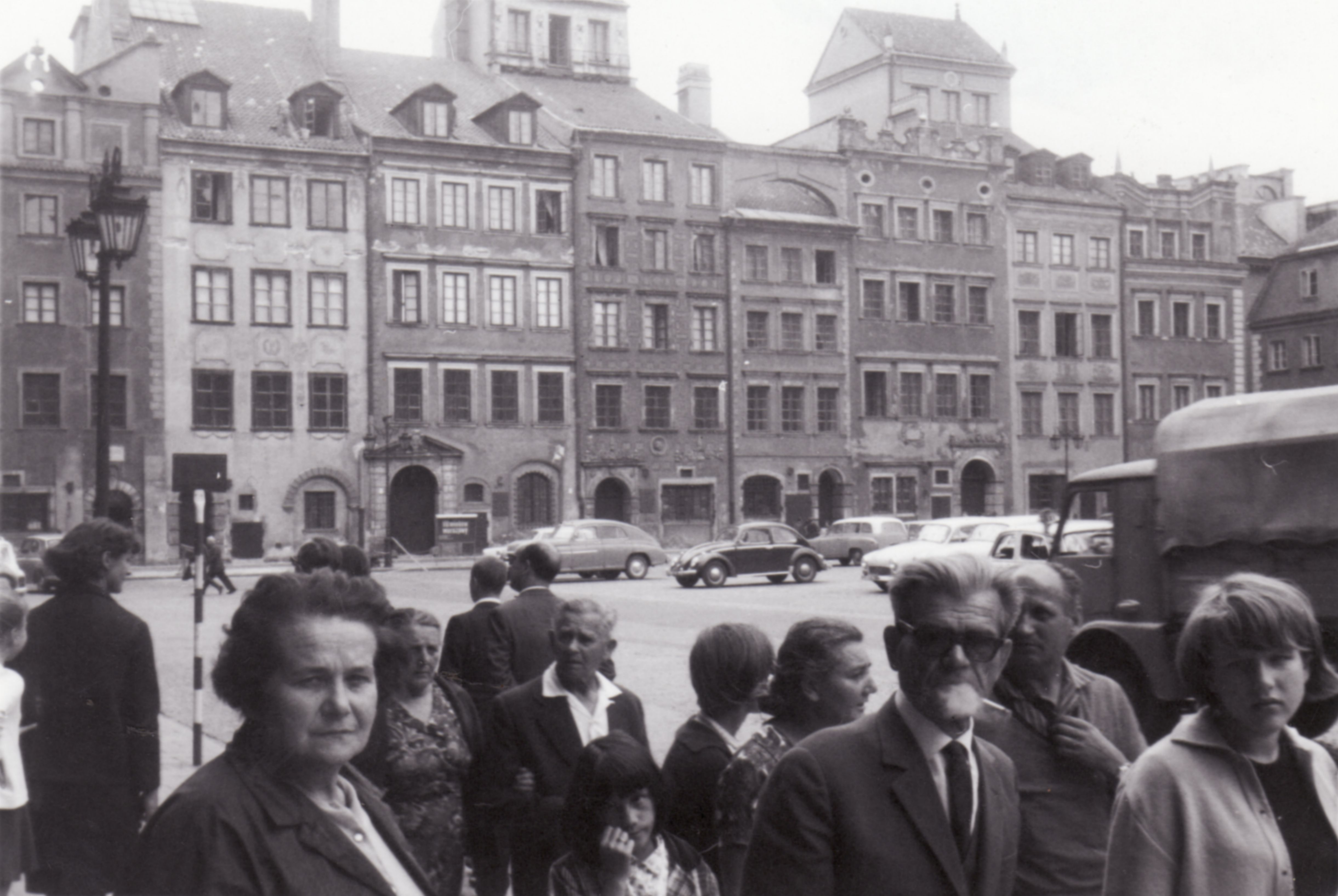
Credit: Benon Tuszyński · 1950–1960 · Public domain · author release recorded on Commons · Open the file record · Licence Public domain · author release recorded on Commons

Dates appear to compete when they are separated from the place, group of buildings or event they describe. BOS organised documentation from 1945; 1949 marks the start of reconstruction in practice in the Museum’s account; and 1953 marks a milestone for the Old Town Market Square.[V03] [V08] [V11] [V05] [V10]
Singleton records that the first residents had moved in by 1951 and that shops and services on the Square opened in July 1953. The Museum dates the rebuilding of Dekert’s Side houses to 1947–1953 and their first exhibition to 1955. These are milestones for different places and uses.[V05] [V09]
Here, the Old Town Market Square is one square within the Old Town district; UNESCO’s Historic Centre names the wider heritage property. Dates for the Square, district and property describe different areas.[V01] [V10]
UNESCO says reconstruction work continued into the mid-1960s. The Square’s 1953 opening therefore does not mark the end of reconstruction across the Old Town.[V01] [V05] [V10]
Milestones for different places and events
Rebuilding the houses on Dekert’s Side[V09]
Reconstruction in practice begins, in the Museum’s account[V11]
The first residents had moved into the Old Town[V05]
First exhibition in the houses on Dekert’s Side[V09]
As-built drawings used in the Piwna Street comparison[V06]
Reconstruction work continues in the Old Town[V01]
Warsaw’s Historic Centre is inscribed on the UNESCO World Heritage List[V01]
06 / 06
What does UNESCO recognise, and what remains different? #
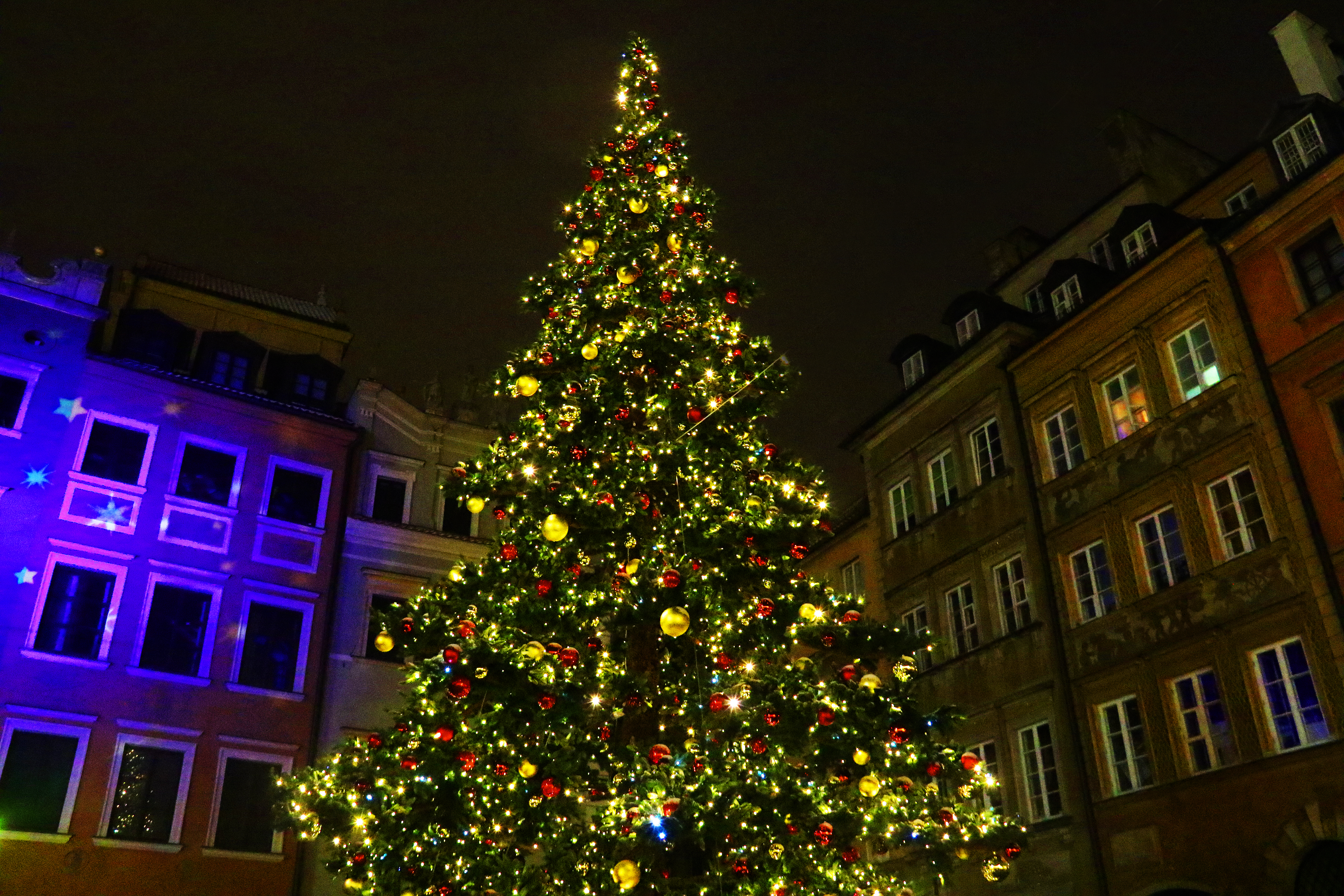
Credit: AnnaBanasiak · 6 January 2022 · CC BY-SA 4.0 · Open the file record · Licence CC BY-SA 4.0

UNESCO inscribed Warsaw’s Historic Centre on the World Heritage List in 1980. Its assessment recognises a reconstruction grounded in historical records, surviving fabric and an interpretation of the city’s late-eighteenth-century appearance.[V01] [V02]
The contemporary photograph records the Old Town in 2022. It documents a place today; by itself, it cannot establish the precise 1950s condition of a particular frontage. The resulting district keeps historic references alongside conservation, design and housing choices made after the war.[V01] [V02] [V05]
07 / 07
Sources and records consulted
Claims are paraphrased and attributed to the institution, study or contemporary account that supports them. Image records and licences appear beside each photograph.
- V01UNESCO World Heritage Centre: Historic Centre of Warsaw
Institutional property account · Undated page; accessed 5 October 2026
- V02UNESCO World Heritage Committee, retrospective Outstanding Universal Value statement, WHC-14/38.COM/8E
Adopted retrospective statement · 2014
- V03State Archives in Warsaw: Warsaw Reconstruction Office exhibition
State-archive account · 27 March 2024
- V04UNESCO Memory of the World nomination dossier: Archive of the Warsaw Reconstruction Office
Archive nomination dossier · 2011
- V05William A. Singleton, “The Reconstruction of Warsaw Old Town, Poland,” Ancient Monuments Society’s Transactions, vol. 7
Contemporary conservation account · 1959
- V06Jerzy Elżanowski and Carmen M. Enss, “Cartographies of catastrophe,” Urban History 49
Peer-reviewed historical analysis · 2022
- V08Museum of Warsaw: Warsaw Reconstruction Route
Museum interpretation · Undated page; accessed 5 October 2026
- V09Museum of Warsaw: History of Old Town Houses
Museum account · Undated page; accessed 5 October 2026
- V10Museum of Warsaw: Old and New Town in Warsaw
Museum audio transcript · Undated page; accessed 5 October 2026
- V11Museum of Warsaw Heritage Interpretation Centre: permanent exhibition
Museum exhibition account · Undated page; accessed 5 October 2026
- V12Royal Castle in Warsaw: Canaletto
Institutional collection history · Undated page; accessed 5 October 2026