Before Columbus
Vikings were felling trees in America in 1021. How can anyone know the exact year?
The Greenlanders’ saga and Erik the Red’s saga tell the same story, contradict each other, and give no year. A dig at the northern tip of Newfoundland shows that Norse people camped there, but does not tell us what they called it. A measurement published in 2021, on three worked pieces of wood from that camp, gives the year: the trees were cut in 1021. That is the year of the felling, not of the first landfall.
Places on a modern mapDays of sailing, not landmarksRuns out where the saga stops naming placesThe excavated camp
What the map can show, and what it cannot
The sea road from Norway to Greenland is drawn here as a solid line. Every harbour on it is a place you can find today, and Norse ships worked it for generations before anyone thought of going further.
Everything west of Greenland is drawn as a dashed line. The sagas measure those legs in days of sailing and in directions taken from the sun, not in landmarks. Two of the names, Helluland and Markland, sit where most scholars put them, off Baffin Island and on the Labrador coast; each dot is a modern reading of a description, not a coordinate anyone wrote down.
Vinland, Leifsbúðir, Straumfjörð and Hóp get no dot at all, because nobody has established where they were. Those routes simply run out into open water. The one square on the map, at the northern tip of Newfoundland, is the camp that was dug up.
Six voyages
The Greenlanders’ saga
Grœnlendinga saga
Copied into Flateyjarbók around 1387
- Voyages west
- Six
- Who sees America first
- Bjarni Herjólfsson, by accident, without landing
The dashed line stops where the saga stops naming places.
In this version the first European to see America sees it by mistake and refuses to go ashore. Bjarni Herjólfsson, sailing from Iceland to join his father in Greenland, is blown off course and passes three unknown coasts. His crew ask to land; he says no. When he tells the story later at the Norwegian earl’s court, it counts against him — he had, the saga says, no report to give about these countries.
Leif Eiriksson buys Bjarni’s ship, takes thirty-five men and goes looking for the lands on purpose. He meets them in reverse order: a country of flat rock and ice mountains, which he names Helluland; a low wooded shore with white sand, which he names Markland; and a third country where the party builds a house and winters. A German named Tyrker comes back one evening saying he has found vines and grapes, and from its produce Leif names the land Wineland.
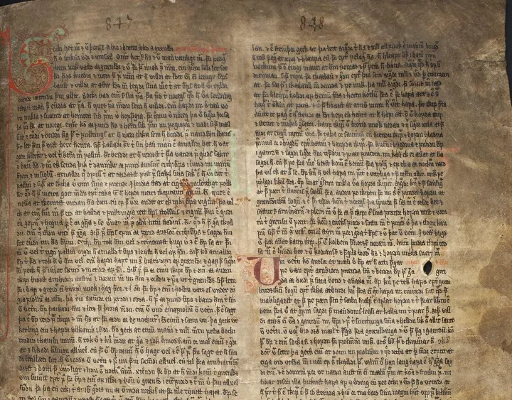
Four more voyages follow, all of them to the same camp, which this saga calls Leif’s booths. Thorvald explores the coast and is killed by an arrow. Thorstein sets out and never arrives. Karlsefni brings settlers and livestock. Freydis, Erik’s daughter, goes last, and has her partners in the venture killed.
Three voyages, no Bjarni Herjólfsson
Erik the Red’s saga
Eiríks saga rauða
Copied into Hauksbók before 1334
- Voyages west
- Three
- Who sees America first
- Leif Eiriksson, blown off course on a mission for the king of Norway
Keelness, Wonder-strands, Streamfirth and Hóp are descriptions, not positions. None of them is on this map.
The second saga has no Bjarni Herjólfsson in it at all; its only Bjarni is Bjarni Grímólfsson, one of Karlsefni’s shipmasters, who gives up his place in a leaking boat and drowns. Leif sails from Norway to Greenland carrying King Olaf Tryggvason’s instruction to bring Christianity to the settlement, is tossed about on the ocean and comes upon lands he knew nothing of. He finds self-sown wheat, vines and maple, picks up shipwrecked men on the way, and that is the whole of his discovery: no named coasts, no winter camp, no second crossing.
The long voyage here belongs to Thorfinn Karlsefni. He passes Helluland and Markland, names a headland Keelness after a ship’s keel found on it and a shoreline Wonder-strands because it takes so long to sail past, and winters at a place he calls Streamfirth. The next season the party splits: Thorhall sails north beyond the Wonder-strands, Karlsefni south to a place called Hóp.
The hand that wrote it
This is the by-name in the manuscript itself, four lines down folio 97 recto of Hauksbók, written in the early fourteenth century — roughly three hundred years after the voyage it describes.
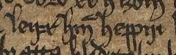
leifr hinn heppniLeif the Lucky
Erik the Red’s saga gives Leif the by-name for rescuing shipwrecked men on his way home, not for finding a new country.

So one saga has six voyages and one camp, the other three voyages and two camps, and they do not agree on who found the country or how. Neither survives in anything earlier than a copy made three centuries after the events it describes. Holding the two accounts apart, rather than merging them into one tidy story, is the only honest way to read them.
Eight buildings, about 800 objects
L’Anse aux Meadows
Newfoundland, 51°36′N
Dug 1960–1968, World Heritage list since 1978
- What it proves
- Norse people built, lived and worked iron here
- What it does not prove
- That this is any place the sagas name
One square, one certain position: 51°36′ north, 55°32′ west.
In 1960 Helge Ingstad was working his way up the coast looking for Norse landing places when a resident of L’Anse aux Meadows, George Decker, took him to a group of overgrown ridges. Over the next eight years Ingstad and the archaeologist Anne Stine Ingstad uncovered eight buildings there: three dwellings, one forge and four workshops, timber frames roofed and walled with turf cut from the bog beside them, built the way houses were built in Iceland and Greenland around the year 1000.
The objects say who lived in them. A bronze ring-headed pin, of the sort used to fasten a cloak, lay in a cooking pit. A spindle whorl, a bone needle and a small whetstone came out of other buildings — a woman’s kit, in Parks Canada’s description, and the reason it is known that the party was not all men. But the find that settled the question was neither: it was the slag left by smelting and working iron, together with a large number of iron boat rivets. Nobody else on that coast was making iron.
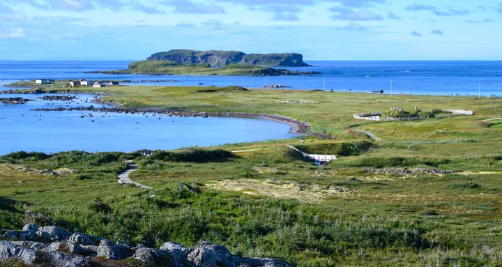

What the ground does not give is a name. Vinland, Leifsbúðir, Straumfjörð and Hóp are descriptions in a text; no object dug out of this soil carries a place name, and no excavation can match one to the other. UNESCO’s citation says the remains correspond with the voyages in the sagas, which is a careful phrase. What is established is a Norse base camp on the northern tip of Newfoundland, used to reach places further south.
How three pieces of wood give a single year
Radiocarbon dating normally answers in ranges, and at this site the ranges were useless. More than 150 radiocarbon dates had been taken at L’Anse aux Meadows, 55 of them on the Norse layer. Together they covered the whole Viking Age, 793 to 1066, and spilled past both ends of it. The camp was Norse; the century was anybody’s guess.
The measurement published in 2021 works the other way round. It does not date the wood directly. It looks for one particular year inside the wood, and then counts rings.
A mark left in trees all over the world
In 993 the amount of radiocarbon in the atmosphere rose by about nine parts in a thousand within a single year. Trees build their wood from the carbon in the air, so that rise is recorded in the ring each tree grew that year, and the same ring carries it on five continents. The 2021 paper calls the cause a cosmic radiation event and leaves it there. Two of the studies it relies on go further: one reads the peaks as most likely produced by extreme solar events, the other as a global exposure to strong solar proton radiation. Both are careful about it, and the date would work the same whatever caused the burst.
Three pieces of wood that still have their bark edge
127 radiocarbon measurements were made on 83 individual growth rings taken from four worked pieces of wood excavated at the camp. One of them, find number 4A 70 B5-14, spans only nine years and cannot contain the 993 ring, so it was set aside. The remaining three come from different trees and at least two species: fir, probably balsam fir, and a juniper or thuja. All three keep their waney edge — the very last ring the tree grew before it was cut. Without that edge there is no felling year, only an earliest possible one.
Finding the 993 ring
Matching the whole measured sequence of each piece against the standard calibration curve puts the three bark edges between 1019 and 1024. That alone means the 993 ring has to lie 26 to 31 rings in from the edge. A second, sharper comparison, against a reference curve measured year by year, finds the drop in the same place in all three pieces: the ring grown in 992 is the twenty-ninth in from the edge.
Counting outwards
If the twenty-ninth ring in is 992, the edge is 1021. The same arithmetic from the other direction: 1021 minus 993 leaves 28 rings, counted from the marked ring out to the bark edge. Two of the three pieces also give a season, from how far the last ring had got when the tree was cut — one in spring, one in summer or autumn.
What 1021 is, and what it is not
1021 is the year these trees were felled. It is not the year Norse ships first reached America, not the year they left, and not the length of their stay. The paper says as much: how 1021 relates to Norse activity across the Atlantic as a whole is left to future research. What the year does fix is a floor under the whole story. Europeans were cutting timber on this continent 471 years before Columbus sailed.
The years that also fit
Other years pass the statistical test at 95 per cent probability as well: 1022 for two of the pieces, and 1019, 1020 and 1022 for the third. What singles out 1021 is that it is the best fit for all three at once, on wood from three different trees. The paper calls that agreement notable and unexpected.
| Find number | Wood | Felling season | Other years that also fit |
|---|---|---|---|
| 4A 59 E3-1 | Fir, probably balsam fir | Not determinable Consolidant applied to this piece in an earlier conservation treatment made the season unreadable. | 1022 |
| 4A 68 J4-6 | Juniper or thuja | Spring | 1019, 1020, 1022 |
| 4A 68 E2-2 | Fir, probably balsam fir | Summer or autumn | 1022 |
A fourth piece, 4A 70 B5-14, was measured and set aside: it spans only nine years, so it cannot contain the 993 ring.
The spade or the saga?
Six statements about the Norse in America. Three are established by what came out of the ground at L’Anse aux Meadows or was measured in its wood. Three appear only in the sagas, and nothing at the camp confirms them.
-
1
They smelted iron on the spot.
Show the answer
The spade
Parks Canada lists slag from smelting and working iron, together with a large number of iron boat rivets, and says this more than any other find identified the camp as Norse. One of the eight buildings is a forge.
-
2
Women were at this camp.
Show the answer
The spade
The sagas put women on the voyages as well — Freydis has a chapter of her own. What the ground adds is that they were here: a spindle whorl, a bone needle and a small whetstone came out of the buildings, a woman’s kit in Parks Canada’s description.
-
3
The wood was cut with metal tools.
Show the answer
The spade
The 2021 date depends on it. All the dated pieces had been worked with metal tools, recognisable from clean, low-angle cuts, and such tools were not made by the Indigenous peoples of that coast at that time. That is the argument for calling the wood Norse.
-
4
They picked grapes and named the country after them.
Show the answer
The saga
In the Greenlanders’ saga a German named Tyrker comes back one evening announcing that he has found vines and grapes, and Leif names the land from its produce. No grapes or vines are among the finds listed for the camp. What those finds do suggest, in UNESCO’s wording, is that the people who used it voyaged further south.
-
5
One of the leaders was killed by an arrow.
Show the answer
The saga
Thorvald Eiriksson’s death is told in the Greenlanders’ saga, and in that saga alone. Nothing in the lists of what was dug up bears on how anyone at the camp died.
-
6
The camp was called Leif’s booths.
Show the answer
The saga
The name is in the text. No object from L’Anse aux Meadows carries a place name, and nothing establishes that this camp is the one the saga means. That is why the 2021 paper calls it a base camp and stops.
Six statements, no answers yet.
From the sagas to the measurement
Nine fixed points, and the distances between them. Two of the nine are modern estimates rather than dates any source gives; they are marked.
c. 985estimated
Erik the Red settles Greenland
The year is reconstructed from later Icelandic writing, not stated in it.
993
A burst of radiocarbon enters the atmosphere
It is recorded in the ring that trees grew that year, on five continents.
c. 1000estimated
The voyages the two sagas describe
Neither saga gives a year. Both set the voyages around the conversion of Greenland to Christianity.
1021
Trees are felled at L’Anse aux Meadows
Three worked pieces of wood, three different trees, one year.
1492
Columbus crosses the Atlantic
471 years after the felling.
1960
Helge Ingstad is shown the ridges at L’Anse aux Meadows
George Decker, who lived there, led him to them.
1968
The first excavations end
Eight buildings, about 800 objects.
1978
The site enters the World Heritage list
Inscribed under criterion (vi), as the first and only known Norse site in North America.
2021
The felling year is published
In Nature, on 20 October 2021.
Sources and method
The year comes from Kuitems and colleagues in Nature, published online on 20 October 2021 and printed in volume 601 the following year. The article is open access under a Creative Commons Attribution 4.0 licence; the numbers used here are taken from its own text, and its figures are not reproduced.
The site facts come from Parks Canada’s pages for L’Anse aux Meadows and from the UNESCO World Heritage entry. The UNESCO page refuses automated requests, so it was read in a browser on 18 September 2026.
The sagas are quoted from Arthur Middleton Reeves’s 1890 edition, which prints both texts in English alongside the Icelandic originals, and checked against John Sephton’s 1880 translation of Erik the Red’s saga. Both are out of copyright.
The map uses Natural Earth’s public-domain coastlines, glacier outlines, lakes and rivers on a Lambert conformal conic projection with standard parallels at 55 and 70 degrees north. A route is drawn solid only where every place along it can be found on a modern map.
The 2021 measurement
- Margot Kuitems, Birgitta L. Wallace, Charles Lindsay, Andrea Scifo, Petra Doeve, Kevin Jenkins, Susanne Lindauer, Pınar Erdil, Paul M. Ledger, Véronique Forbes, Caroline Vermeeren, Ronny Friedrich, Michael W. Dee, “Evidence for European presence in the Americas in ad 1021”, Nature 601, 388–391 (2022), published online 20 October 2021The measurement that fixes the year, and every figure quoted here for the wood, the rings and the earlier radiocarbon dates.
- Ulf Büntgen et al., “Tree rings reveal globally coherent signature of cosmogenic radiocarbon events in 774 and 993 CE”, Nature Communications 9, 3605 (2018)The worldwide tree-ring measurements behind the 993 marker, and the reference curve the exact-year match is made against.
- Florian Mekhaldi et al., “Multiradionuclide evidence for the solar origin of the cosmic-ray events of AD 774/5 and 993/4”, Nature Communications 6, 8611 (2015)The ice-core evidence for what caused the 993 burst, cited here for the wording of its own conclusion.
The excavated camp
- Parks Canada, L’Anse aux Meadows National Historic Site, “Culture and history”The buildings, the objects and the excavation history, from the agency that manages the site.
- UNESCO World Heritage Centre, L’Anse aux Meadows National Historic Site, list entry 4The inscription text, the building count and the protected area.
The sagas
- Arthur Middleton Reeves, The Finding of Wineland the Good, Oxford, 1890 (Internet Archive)Both Vinland sagas in English, with the Icelandic texts and the manuscript plates.
- John Sephton, Eirik the Red’s Saga: A Translation, Liverpool, 1880 (Internet Archive)Erik the Red’s saga on its own, used as a second reading of the same text.
The map
- Natural Earth, 1:50m land, glaciated areas, lakes and rivers (public domain)Coastlines, glaciated areas, lakes and rivers at 1:50 million.
Pictures
- L’Anse aux Meadows from the hill above Epaves Bay, 2022. Photograph by Gordon Leggett · Wikimedia Commons · CC BY-SA 4.0
- The excavated ground at L’Anse aux Meadows. Photograph by SemanticsDavid · Wikimedia Commons · CC BY-SA 3.0
- Flateyjarbók, the first page of the Greenlanders’ story. Scribes Jón Þórðarson and Magnús Þórhallsson · Wikimedia Commons · Public domain
- Hauksbók, AM 544 4to, folio 97 recto, line 4. Photograph by the Arnamagnæan Collection · Wikimedia Commons · Public domain
