Chapter 9 · Life, health and conservation
What does a dot on a species record map prove, and what does an empty spot fail to prove?
- Size
- from 19.5 km to 744 km
- Level
- population and ecosystem
- Time
- a decade of observations
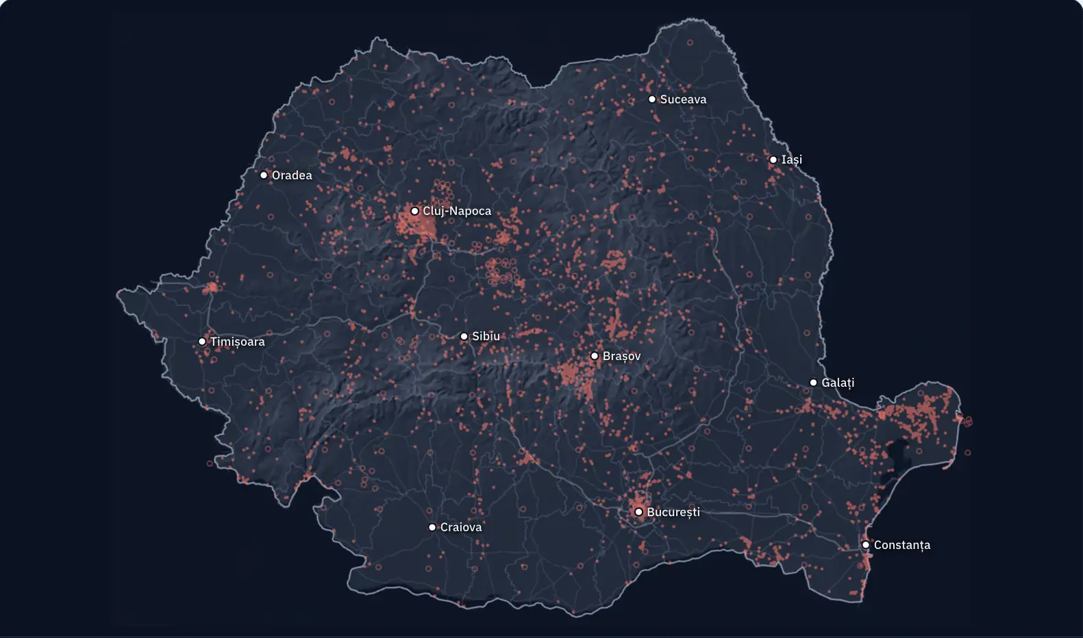
On the map beside the text there are 17,376 dots: all the great tit records from Romania sent to GBIF with coordinates, the world database on biodiversity. Almost every dot says that someone saw or heard a bird there and noted it; 10 are of another kind: museum specimens, records made by machines or records with no type given. What such a map actually measures remains to be found out.
Where do the brown bear records gather?
The genetic study of the Ministry of the Environment estimates between 10,657 and 12,787 brown bears in Romania. In GBIF there are 1,420 records of brown bear from Romania with coordinates and no position problems flagged: 20 from the year 2020 and 305 from 2025.
The map now shows only the relief, the counties and the main roads.
Where do you think the most dots are?
One dot: a species, a place and, usually, a date
An occurrence record has a species, a place and, most often, a date. It can be a person’s observation, a photograph, a museum specimen or the recording of a machine. The card on the map shows one of them: an observation by a person from 2026, published in the dataset “Observation.org, Nature data from around the World”, with the licence CC BY-NC 4.0.
The brown bear is a protected species. The people who publish the observations blurred the place for 1,404 of the 1,420 records, with an uncertainty of up to tens of kilometres, so the map shows them only in squares of about 30 km.
The fullest square, 46 km from Râmnicu Vâlcea, has 26% of the records. The squares among the most observed 10% for all species add up to 19% of the brown bear records.
Dots gather where there are many observers
Under the dots, coloured cells have now appeared: how many records there are in each, all species together. The lightest ones sit on the big cities and around them.
The most recorded 5% of cells add up to 60% of all records. The same cells hold 77% of the great tit dots.
The municipality of Bucharest alone has 56,733 records of all species.
A place with few dots is not a place without life
The hatched cells have fewer than ten records, all species together, from all years: 250 of Romania’s 3,941 cells. In 12 of them, no record appears at all. Most cells with so few dots are in Teleorman County: 23.
A cell covers about 64 square kilometres of forest, pasture, rivers or villages. Far more than ten species live there. The few dots say only that few observations were sent from there. The absence of a record does not prove the absence of the species.
Bears reported in Vaslui and Iași, no dot on the map
Vaslui and Iași are counties in eastern Romania. On 10 November 2026, the newspaper Ziarul de Iași wrote about a bear reported at Dobrovăț, in Iași County; forest rangers were tracking the animal, and the mayor thought it might be the bear seen recently at Negrești, in Vaslui County, which was not confirmed. Two days later, Ziarul de Interes wrote: “In Vaslui alone, the authorities have reported ten animals” (translated from Romanian). The article does not name the authorities and does not say how the animals were counted.
In GBIF there are 1,425 records of brown bear from Romania, with or without coordinates; on the map are the 1,420 with coordinates. None lies in Vaslui or Iași, although people sent 14,524 records of other species from Vaslui and 36,022 records from Iași. Brown bear records exist in 24 of the 42 units (41 counties and Bucharest).
The ministry’s genetic study gives no value for these two counties. The square at the edge of Iași County stretches over its border, because the positions are rounded to about 30 km; its records come from other counties. Read as a map of bears, the picture would say that there are no bears in Vaslui. The picture says only that no GBIF brown bear record lies in Vaslui.
More dots do not necessarily mean more storks
Until 2010 there were 354 records of white stork from Romania. Today there are 9,366; the largest number is from 2025: 1,459. The number of records alone does not show whether the storks have become more numerous: in the meantime phone apps have appeared and more and more people send in observations, which may explain a large part of the increase.
To find out where a species lives and how its population changes, researchers use observations with a known effort: the same routes, the same duration, repeated year after year, and complete lists, in which the observer notes every species they recognised. A study on eBird data found that maps improve most with complete lists, from which the places where the species was not found can be deduced, and with information about the effort behind each list.
National parks show on the map partly because people go there
The green outlines are 11 of the 13 national parks and the Danube Delta Biosphere Reserve; Călimani and Piatra Craiului are missing, because the map used does not have their outlines. The outlined areas hold 3.2% of Romania’s cells and 16% of the records of all species.
Edelweiss grows on the rocks of the high mountains. In 1933 it was one of only two flower species protected by law in all of Romania. Of its 181 records, 80 are in Prahova County and 38 in Brașov County, where the Bucegi Mountains, a natural park, and Piatra Craiului lie.
A protected area has many rare species. It also has marked paths, mountain huts and visitors who photograph what they see.
Now you explain
Ragweed is an invasive species, controlled by law. In GBIF it has 9,936 records from Romania: 775 in Arad County and 28 in Covasna County. A classmate says: “There is no ragweed in Covasna.” What do you answer?
Compare with an answer
The 28 records from Covasna County show that ragweed was found there; each identification has to be checked. 65% of the ragweed dots come from a single survey, “alien_plant_ro”, made between 2019 and 2022: botanists surveyed squares of 100 km² chosen at random, along routes of 50 km each. The places the routes did not cross remain without dots. To find out whether ragweed is missing from a county, it must be searched for there with the same method and the same effort as in the county with many dots.
A class can add a correct record: the date, the place with coordinates, a clear photograph and the name of the person who identified the species. On iNaturalist, an observation becomes “research grade” when it has a date, a place and a photograph or a sound, is of a wild organism and, usually, more than two thirds of those who identified it agree on the species. More rarely, it gets there with a genus or family name, when the community decides it cannot be identified more precisely. It reaches GBIF if the author has also given it a licence that allows reuse.
The lesson on biodiversity conservation, with the worked example of the bears