Craiova, Dolj county
The park drawn before it existed
In 1900, the plan of a park in Craiova was exhibited in Paris. The park opened three years later, with the king present. Lay it over your own town, to scale, and measure what the guides say about it.
92.89 ha · 29 September 1903 · one plan, numbered 1 to 55

The paper
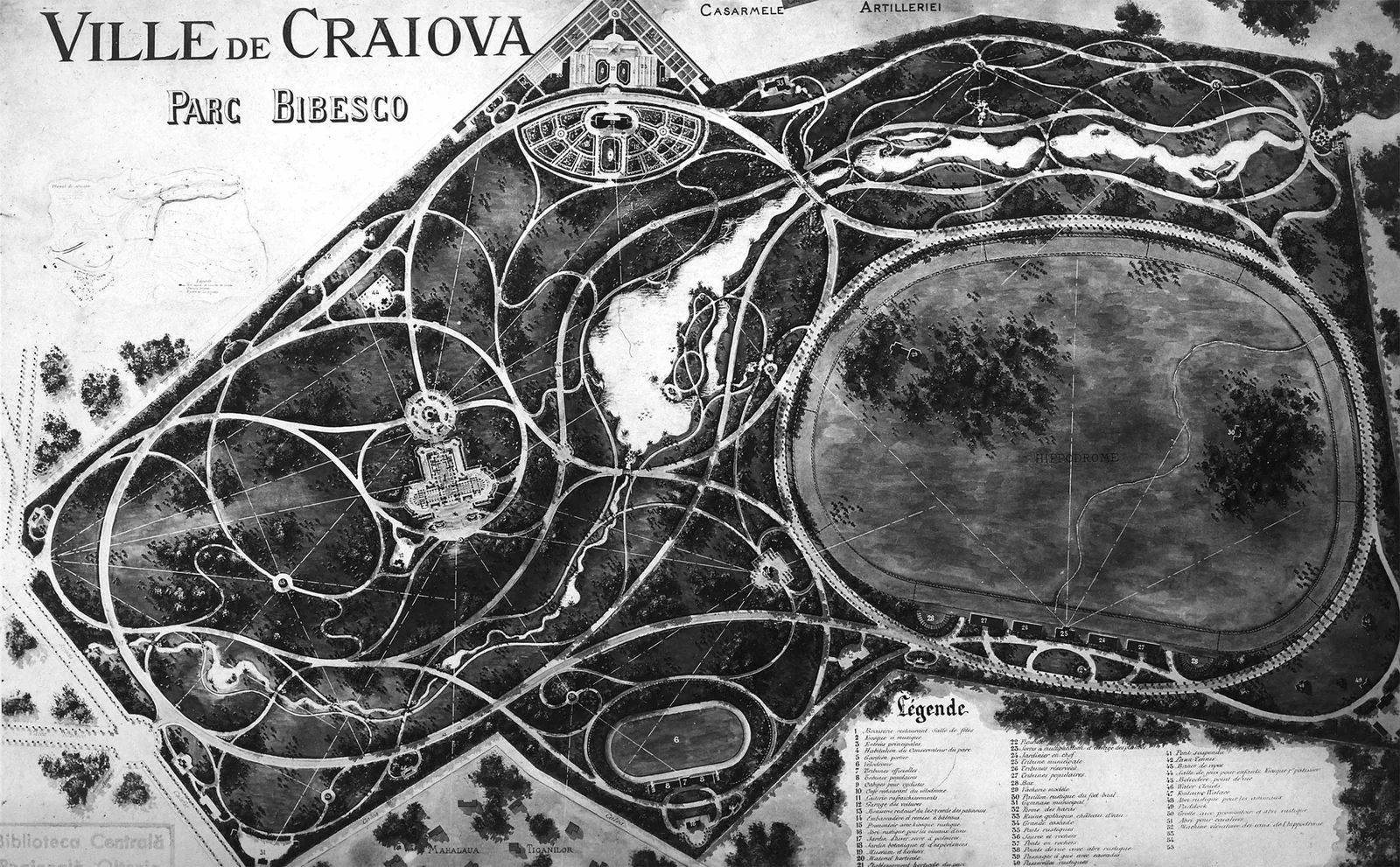
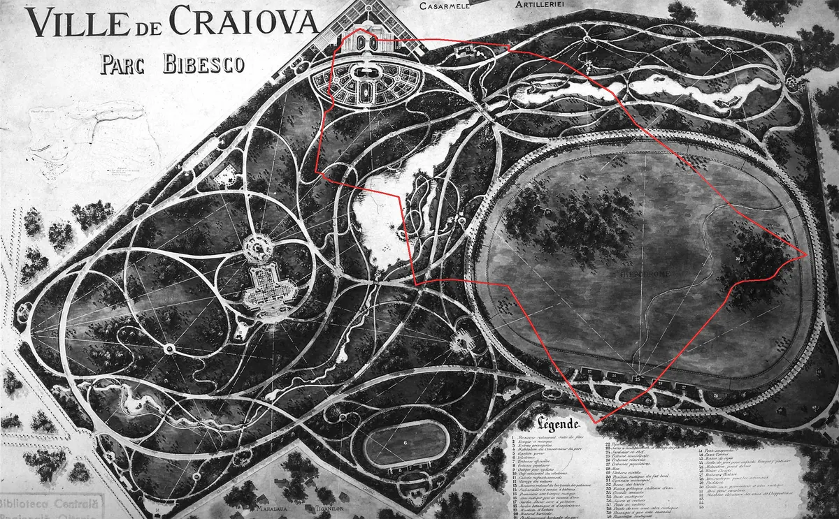
Before it had alleys, the park had a drawing sheet. The Aman county library keeps it under the stamp of the old Oltenia Regional Central Library: “VILLE DE CRAIOVA / PARC BIBESCO”, with its legend in French and 55 numbered features.
The sheet shows the hippodrome with its stands, the linked lakes, the suspended bridge, a velodrome with stands, a “ruine gothique, château d'eau”, a water castle, plus greenhouses, kiosks, a dairy and a model theatre. Above the road stand the “CASARMELE ARTILLERIEI”, and at the southern edge the “MAHALAUA ȚIGANILOR”. The map says by itself where Craiova stood then.
After the Aman library, the architect appointed for the project was Edouard Redont, “who also designed the National Exhibition in Carol Park, Bucharest”. The county council's tourism portal agrees. Redont took the project of the future park to the International Exhibition in Paris in 1900, “and the project was awarded the Gold Medal”, again after the library. The Paris prize list was not found online, so the medal stays the Craiova sources' claim, not a verified fact.
Redont (1862–1942), a landscape architect from Reims, is listed by the French heritage inventory as “Redont ; Edouard (architecte paysagiste)”. In Bucharest his plan still stands as Carol Park — more at the parks of Bucharest; his story here stops at Craiova.
The legend reads like a menu of the last century: music kiosk and brasserie, velodrome, lawn tennis, a suspended bridge and a gothic ruin hiding a water castle. What the scan does not show speaks as loudly: no graphic scale, no signature, no date. A sheet for showing, not for measuring.
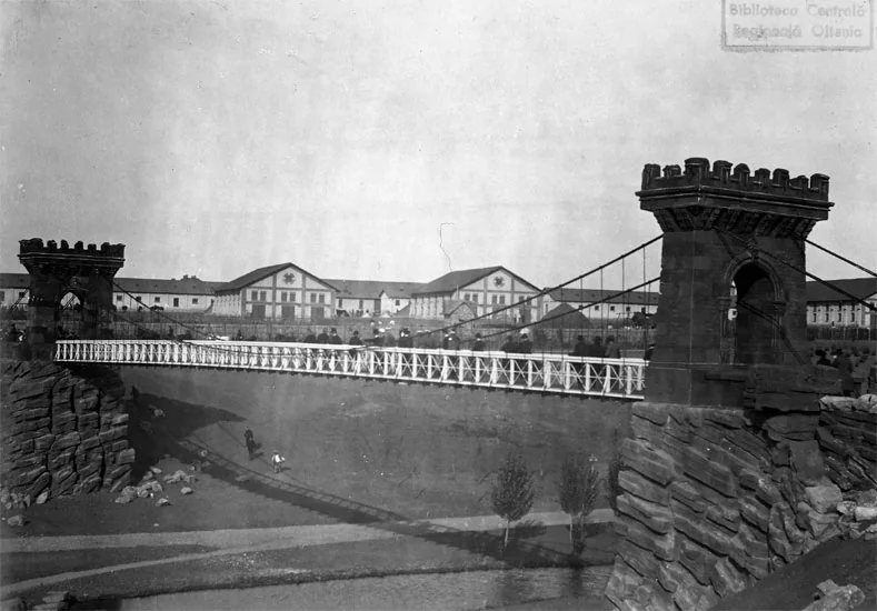
The suspended bridge on the plan (feature 41) still spans the valley; the library keeps its foundation, diggings and inauguration photographs.
- Measured area
- 92.89 ha (OpenStreetMap, way 28132031)
- Opening
- 29 September 1903, in the presence of King Carol I
- Project
- Edouard Redont, exhibited in Paris in 1900; Gold Medal, after the Craiova sources
- Fence line
- a 4.4 km lap, about 53 minutes at a normal pace
The building
The ground was not empty: a mid-19th-century garden of logothete Ioan Bibescu's estate, pavilions and greenhouses kept by a German gardener. After 1848 the town bought the estate for a public garden, but the plan stalled, and by the century's end the place was an insalubrious fringe: the lake a source of infection, the town stables on its bank, the former summer residence an asylum for the infirm.
- the park fence
- lakes
- alleys
- places
1903
The gate
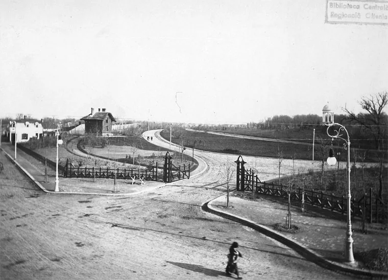
The main entrance faces north, with the gate house and the curving alley from the photograph. Romanescu's bust was raised here in 1943, and today's portal and fence date from 1954–56.
1903
The lakes
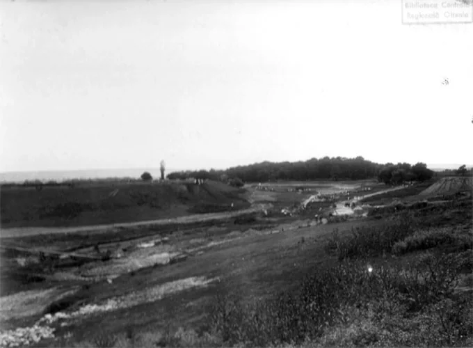
The upper and lower lakes were dug from scratch, with intakes and dikes on the Valea Fetei. Today's landing stage stands on the great lake's bank, some 360 metres from the bridge.
1903
The bridge
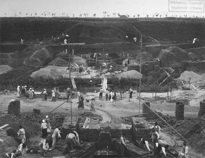
The suspended bridge, feature 41 on the plan, joins the banks over the valley. The library keeps its underground foundations, the diggings and the inauguration photograph.
On the map: the red dot at the lake's eastern end.
1903
The water castle
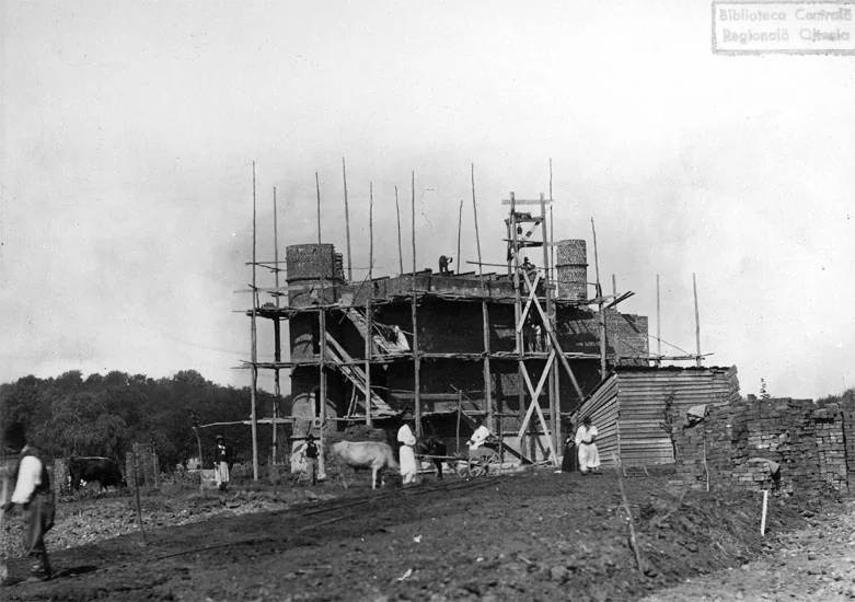
The enchanted castle, feature 33, is a decorative gothic ruin cladding the park's giant irrigation basins. Its basins used to irrigate the alleys.
The English Wikipedia says 1905; the inauguration photograph shows it finished in 1903.
1903
The hippodrome
Twenty hectares on the south-eastern edge, the country's largest hippodrome at the century's start. The stands and the popular buffet from the photograph have long stopped receiving guests: the library says all quiet since 2000, the English Wikipedia mentions athletics competitions.
1900 / today
The velodrome
The plan draws a large velodrome with an official stand and a popular terrace. Today's track is far smaller and stands elsewhere: the plan's oval lands some 480–640 metres south of it.
today
The measure
Inside the fence lie 92.89 ha, and the lap runs 4.4 km. The map below lays these hectares over your town.
In 1898, after Nicolae Romanescu was designated mayor, the town's modernisation project was voted, with parks and gardens among its aims. That is where the building site starts: digging the two lakes, water intakes and dikes on the Valea Fetei, metalling the alleys, raising the water castle and the bridge's foundations in stone. The library's photographs show it all: the bare earth, the piles, the waterfall under test.
The sources do not agree on when it started. The Aman library writes that “the building of the park began in 1897”, hence before the 1898 vote. The Romanian and French Wikipedias say the laying-out began in 1901 and finished in 1903. The county portal names no starting year: the opening came “after three years of uninterrupted work”. All three stand, unreconciled: what is certain is the day at the end.
The day was 29 September 1903. The park was opened “with great pomp, in the presence of King Carol I”. The 20-hectare hippodrome opened that same year, the largest in the country at the century's start, after the library. After the library, no activity has taken place on it since 2000; the English Wikipedia mentions athletics competitions.
The heaviest work went into the Valea Fetei, the valley crossing the park: piles and dikes, water intakes, slopes graded once the rubbish was cleared, barracks demolished, after the captions. The nursery raised the saplings, and planting closed the site in green.
The closing photographs show the result: a general view with the hippodrome, one toward the main entrance, an inauguration photograph each for the water castle and the bridge. The last image is the Calafat boulevard.
Your town under the park
Today's park can be measured: 92.89 hectares inside the fence, after the OpenStreetMap survey. Choose your town: the map lays the park over it, at true scale, with the two rivals the guides mention. What you see is the reckoning, not the opinion. The dotted circle is one kilometre: the park fits inside.
- counties
- parks
- the chosen town
- 1 km circle
The measurement
The guides praise the park, each differently. Every sentence below is quoted exactly; the translations from Romanian are mine, and their sins of logic are theirs, not the page's.
What the guides say
- The Aman library, Craiova
“the largest natural park in Eastern Europe, by extent second in Romania, about 90 ha, after Herăstrău … the largest urban green area in Romania.”
Second after Herăstrău alone cancels the “largest” in the same sentence.
- tion.ro
“the largest urban green area in Romania and the third natural park in Eastern Europe … about 100 hectares and … second by size in Romania, after Herăstrău Park.”
“Largest urban green area” and “second after Herăstrău” cannot both be true.
- French Wikipedia
“Il est le troisième plus grand parc urbain en Europe.”
The third largest urban park in Europe, with no measurement beside it.
- English Wikipedia
“It is wrongly considered in pop culture as the largest natural park in Eastern Europe. It is actually an urban park.”
The only one to say out loud that it is an urban park, not a natural one.
- Romanian Wikipedia
“By extent it is first in Romania, with about 96 ha, followed by Herăstrău Park in Bucharest, with 4 ha.”
“Herăstrău, with 4 ha” is a data error of the source; the page shows it and does not repeat it.
What the measure says
With the same method on all three, the “leisure=park” polygon in OpenStreetMap and the same area formula, the results are: Tineretului 149.9 ha, Herăstrău 137.89 ha (from three polygons: 51.8 + 35.06 + 51.03), Romanescu 92.89 ha. The independent test: the Bucharest-parks project measured the same objects and found 137.2 and 149.0 ha; the differences, at most 0.9 ha, are small beside the 45.0-hectare gulf between Romanescu and Herăstrău.
The order holds however you turn the published figures: Craiova's park comes after Herăstrău, which alone cancels, between parks measured alike, “the largest in Eastern Europe” and “the largest urban green area in Romania”. And “second in Romania” falls at the measure too, because Tineretului is larger than both.
As for “natural park”: people drew, dug, planted and fenced it, in the middle of a city. It is an urban park by definition, as the English Wikipedia also says. “Natural” is a pretty word here, not a category.
How it was measured: each park is a “leisure=park” polygon in OpenStreetMap, and the area comes from the same shoelace formula. Romanescu and Tineretului are hand-drawn, with dozens of nodes on the outline; Herăstrău comes from three older remote-sensing polygons. That is why the independent test matters: the Bucharest-parks project measured the same objects on its own and found nearly the same figures. The order does not hang on decimals: between Romanescu and Herăstrău lie 45.0 hectares, fifty times the gap between the two reckonings.
The guides also say the roads, alleys and paths “total over 35 km in length”. The OpenStreetMap survey counts 24.65 km in 177 ways inside the fence today. The difference may be unmapped trails, not lies in the guides; the page shows both values.
The misfit
The Paris sheet is beautiful, but it is not a survey. Laid over today's park, it does not fit: the page's computations give errors over a hundred metres, and the drawing's western half falls outside today's fence.
The test was run five ways, on landmarks matchable today — the gate, the bridge, the castle, the stands, the lakes — with the bridge and castle picks the shakiest. No fit escapes errors over a hundred metres, and the plan's velodrome oval lands some 480–640 metres south of today's cycling track. Either the drawing is an exhibition watercolour, with artistic licence, or the built park has since lost a good piece of its west and south.
Without a survey of the period, the page cannot decide between the two, so it lays not the drawing over your town but today's measured park, 92.89 ha inside the fence. The drawing stays what it was in Paris: the project, not the ground.
In short: the sheet was fitted to the ground five ways, on today's landmarks. The best fit errs by 35–135 metres on its anchors and some 480 at the velodrome. Redont's book on Craiova, or a period survey, would settle it; neither was found online.
Go
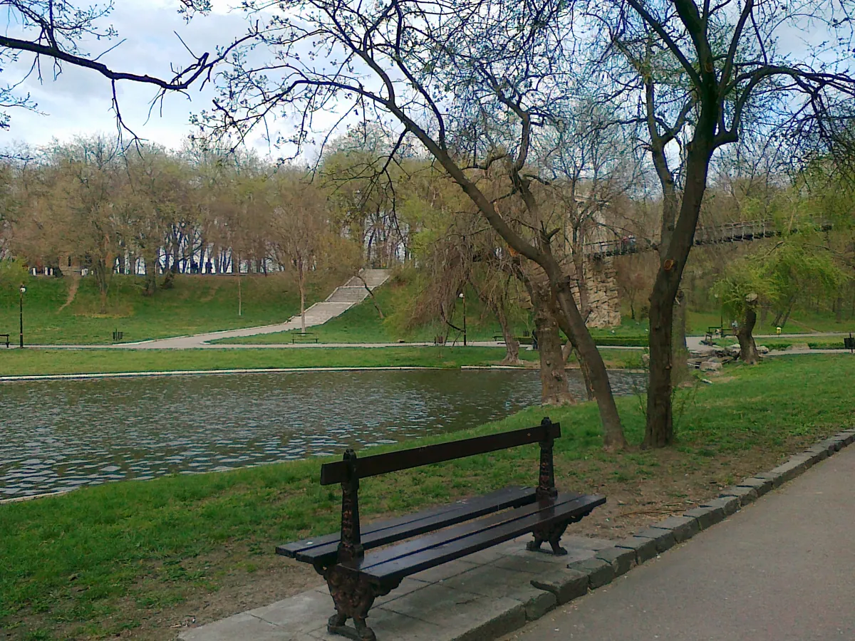
The park lies in southern Craiova, its great gate facing north. Go in, pass the 1943 bust, climb to the hill pavilion, then walk down to the lake: the suspended bridge, the water castle and the landing stage all stand within a few hundred metres of each other. The park also holds a zoo, built at the start of the century too, after the library.
The fence line measures 4.4 km, about 53 minutes at a normal 5 km per hour pace; the longest crossing, 1599 metres as the crow flies, takes some 19 minutes. And if you want to see the Paris sheet with your own eyes, it is at the Aman library, under “Local memory”.
For the walk, the reckoning helps: 24.65 km of alleys are on the free map; the lap of the fence would take 53 minutes. The zoo stands in the park too, and the lighting modernisation dates from 1964, again after the library.
By the same Frenchman's hand, in Bucharest: Carol Park.

Sources and method
The park's history, project and dates come from two Dolj institutions, whose pages were read on 11 October 2026. The measurements in the text — hectares, kilometres, walking times — come from the page's own computations on the free OpenStreetMap survey; the source ways are public (see the Measure below) and anyone can check them.
History, project, dates
- The “Alexandru și Aristia Aman” county library, “Parcul Nicolae Romanescu” — the project, the architect, the medal, the building site, the hippodrome, the bust, the portal: “the architect appointed for this project was Edouard Redont”; “the building of the park began in 1897”; “and the project was awarded the Gold Medal”. memorielocala.aman.ro
- The Dolj county council, “Parcul Romanescu, 121 de ani de frumusețe în sufletul Craiovei”, 27 September 2024 — the 1898 vote, the opening, the three years of work: “On 29 September 1903 the park […] was opened with great pomp, in the presence of King Carol I, after three years of uninterrupted work.” discoverdolj.ro
- The French Ministry of Culture, Mérimée database, notice IA51000885 — the name and trade: “Redont ; Edouard (architecte paysagiste)”. pop.culture.gouv.fr
- The Romanian Cultural Institute, “Nature and architecture: the parks and gardens of the capital” — calls him “Ernest Redont” and credits him with the Bibescu-Romanescu park in Craiova; “Ernest” is treated as the source's error. icr.ro
- tion.ro, “Parcul Nicolae Romanescu, cea mai mare zonă verde urbană din România” — one of the sentences quoted in the Measurement. tion.ro
- The Romanian, English and French Wikipedias (the articles on the park and on Édouard Redont) — quoted as carriers of the superlatives, each checked on its own revision; their figures do not enter the page's reckoning. ro.wikipedia.org · en.wikipedia.org · fr.wikipedia.org
Images
- The lake photograph: Sandri 90, Wikimedia Commons, CC BY-SA 3.0. the file
- The suspended bridge today: Deedeeshor 77, Wikimedia Commons, CC BY-SA 3.0 RO. the file
- The project sheet and the building-site photographs: the “Alexandru și Aristia Aman” county library, the “Local memory” collection (period photographs, not individually dated, unknown photographers; the library's scans, with thanks and a link). memorielocala.aman.ro

The measure
- Areas: the shoelace formula on the OpenStreetMap polygons (Romanescu way 28132031; Herăstrău ways 88337012, 91797290, 88337000; Tineretului way 14360895). Independent test: the Bucharest-parks project measures the same objects at 137.2 and 149.0 ha.
- Alleys: summing the OpenStreetMap road segments with one end inside the fence (177 segments, 24.65 km); trails unmapped on the survey are missing from the total.
- The misfit: five fits (similarity and affine) between the sheet scan and today's landmarks (gate, bridge, castle, stands, lakes, hippodrome, velodrome); the reckoning and the figure are described in the Misfit section.
The map
- OpenStreetMap: Nicolae Romanescu Park (way 28132031), the lakes, alleys, suspended bridge, enchanted castle, hippodrome, velodrome and park buildings; Herăstrău (ways 88337012, 91797290, 88337000); Tineretului (way 14360895); the Jiu river (relation 7691863). © OpenStreetMap contributors, ODbL. openstreetmap.org
- Relief: hillshade computed from AWS Terrain Tiles (Terrarium), Mapzen data from SRTM and other sources. registry.opendata.aws
- County outlines: the map of the project Unde-i ăla?.
- County-capital coordinates: the list of the project Oradea; distances and bearings to Craiova are recomputed here.