Oradea · Bihor County · western Romania
Oradea Fortress: the walled star that spent 32 years as a pashalik capital
Five bastions on a 1,614-metre circuit, raised between 1570 and 1660 from a plan whose author appears in no document; 44 days of siege in the summer of 1660; then 32 years as the seat of the Pashalik of Varat, an Ottoman province. The star at true scale, over any town — then the building, stone by stone.
1,614 metres of wall · 5 bastions · 32 years of pashalik
The star at true scale
The walls measure 1,614 metres round and enclose 6.25 hectares — about 8.8 football pitches. The figure lays the fortress's true outline, to scale, over the centre of any chosen town; walking the walls at 5 kilometres an hour would take 19 minutes.
Oradea, Bihor: 1 km to the fortress, east. Round the walls: 19 minutes.
a 105-by-68-metre pitch · round the walls at 5 kilometres an hour · Fortress outline: OpenStreetMap, the wall circuit. Bánlaky's sketch, from the 1928–1942 series, confirms the order of magnitude, not the metres.
The star, stone by stone
From the first stone to the museum, in eighteen stops: the building, the 1660 siege, the pashalik, and what followed.
schematic, not surveyed
Skip to the end of the storyThe 3D model did not start on this device; the outline is the true one, to scale.
Building, 1570–1660
1. The first stone, 1570
The pentagonal plan was ready by the spring of 1570 at the latest; that same year work began on one bastion — the southern Crăișor (Királyfia), the only one whose placing fixed the whole star from the start. The name of the Italian who drew the plan appears in none of the documents brought to light by 1947. The name in circulation, Baldigara, belongs to another building site: Giulio Baldigara drew the pentagonal fortress of Satu Mare (Szatmár), between 1569 and 1573.
2. The 1581 inspection
On 1 February 1581 King Stephen Báthory sent his engineer, Domenico Ridolfini of Camerino, from Warsaw to Oradea with nine points to check and orders to bring back a wooden model of the fortress. The instruction itself shows the fortress's state: the bastions standing, casemates and all, but with no parapets — and the gate's site still undecided.
3. The lion on Aurit, 1583
The northern bastion, Aurit (Aranyos), belongs to Ridolfini's years: its building date, 1583, is kept by the Báthory arms held by a lion on the bastion's crest — as the art historian Jolán Balogh records it in 1947.
4. Four of stone, one of earth, 1595
Isolani's report of 23 September 1595: four bastions finished, faced with stone; the fifth unfinished, propped for the time being with a palisade. The townspeople called it the earth bastion. By then the works had also passed through the hands of Simone Genga of Urbino — 675 thalers for nine months, by the account books.
5. Five weeks, 1598
In the autumn of 1598 the still unfinished fortress held out through five weeks of siege, writes Balogh: 25 September to 3 November, by the city chronicle, which also counts among its relief the 1,500 horsemen sent by Michael the Brave.
6. One summer, 1618
Prince Gábor Bethlen rebuilt the earth bastion in stone in a single summer, to the measure of the Red bastion: the architect Giacomo Resti, an Italian — the books give his home as Bern, in which Balogh reads Verona — passed through Cluj on 29–30 January and measured while the water stood frozen; the prince ordered 1,000 day-labourers for the foundations, 50 masons arrived in May, and in summer some 600 more men from the counties. The cornerstones carry the year 1618.
7. The palace within, 1619–1660
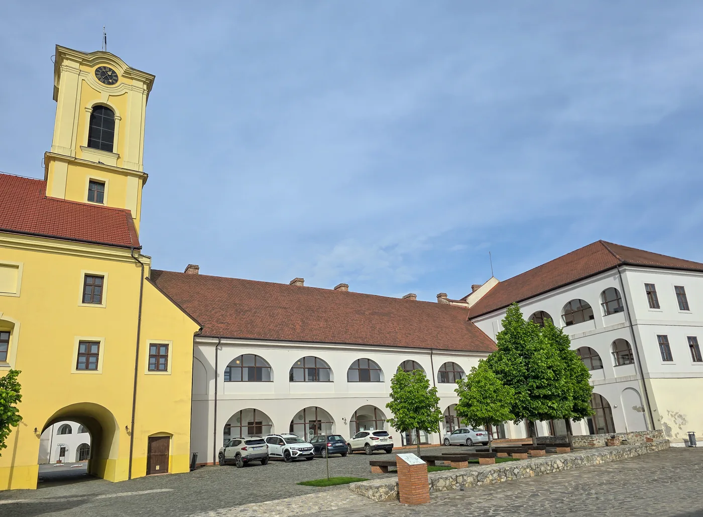
Inside the walls a second pentagon rose, a palace: Resti until 1631, then, under Prince Rákóczi I, the master Imre deák. The last piece of the cathedral came down in December 1639; the courtyard held the bronze equestrian Saint Ladislas of 1390; on the Aurit bastion, a summer pavilion; over the gate, a tower with bells and a clock. The works went on under Rákóczi II too, with builders at Oradea in 1649, 1652 and 1657; by 1660 the palace stood finished in essence, if not in every detail.
The siege, July–August 1660
8. The camps, 14 July
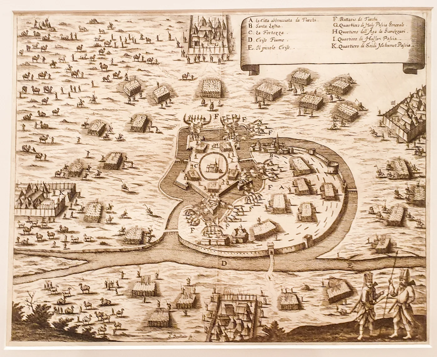
On 14 July the Turks pitched their camps on the banks of the Criș and in the surrounding vineyards and orchards. The fortress gates were walled up; the townspeople who had not fled took shelter inside; the town itself was set on fire. The defenders — townspeople and students of the college — numbered under a thousand, in Köpeczi's History of Transylvania; the city chronicle says 850, against tens of thousands of besiegers.
9. 44 days
The defenders held out for 44 days. The enemy drained the moat; munitions ran out. The strip counts the days from 14 July: day 44 falls on 27 August — the city chronicle's date. Köpeczi prints 17 August, ten days earlier: exactly the gap between Old and New Style in 1660. No source says this is the explanation; the question stays open.
14 July + 44 days = 27 August; Köpeczi prints 17 August.
10. The surrender, in five points
The fortress surrendered conditionally: Turkish rule would not pass beyond the bounds of the Oradea domain; the garrison would march out under arms; the townspeople would stay or leave under escort; Ali would intercede for a lower tribute; the school's fittings and the printing press would leave with the defenders. Barely 300 men walked out of the fortress.
11. The moat and the legend
The drained moat is a fact of war, recorded by Köpeczi. The city chronicle adds a betrayal, with no mechanism; the miller's legend says the traitor showed the Turks where to dig to open the moat's sluices. A legend stays a legend: it is told, not counted.
The pashalik, 1660–1692
12. Varat, a pashalik
Oradea became the seat of the Pashalik of Varat, a province under direct Ottoman rule. The pasha's name reads from 1662: Küçük Mehmed received orders alongside Ali of Timișoara, and the documents name Hamza, pasha of Varat. Thirty-two years: 1660–1692.
13. The church becomes a mosque
The Turks repaired the siege damage — the north-eastern range, between the Red and Aurit bastions, had been badly hit — and turned the fortress church into a mosque.
14. Vasvár, 1664
The Peace of Vasvár, 10 August 1664: Oradea, Lugoj, Caransebeș and Ineu, with the districts subdued since 1657, were acknowledged to the Ottoman Empire. In May, a few months earlier, a surprise attack by László Rákóczi had failed beneath the walls, and the count had fallen shot.
After the Turks, 1692–today
15. June 1692
The imperials besieged the fortress from 1691; the struggle lasted close to a year, and the Turks surrendered in June 1692, in Köpeczi's account — the city chronicle ends the siege on 28 May. Only the roofs of the inner palace burned, but the bell-and-clock gate tower was destroyed; the captain had the palace roofed before winter, and the church passed to the Jesuits.
16. The Austrians rebuild
Between 1692 and 1695 the fortress was rebuilt, says the city chronicle, to the plans of Baron Ernst von Borgsdorf — with money from the Vatican treasury too, 60,000 florins, a figure the chronicle misprints a zero short. The campaigns of 1725, 1754–1755 and 1775–1777 finished the ensemble visitors see today.
17. 1881: the Bethlen wing falls
In 1881 the west wing of the inner palace — Bethlen's palace — was demolished, a graver loss than any siege damage, writes Jolán Balogh; a bleak barracks block rose in its place.
18. From barracks to museum
450 French prisoners in November 1793, 300 in November 1813, most of them ill; a fire in 1836; the decree of 16 May 1857 lifted the military character for good, though the fortress remained an auxiliary military site; between the wars, a gendarmerie school. From 1947 to 1952 the north wing of the princely castle housed a transit camp. The European-funded restoration, 2009–2015; on 19 May 2020 the Oradea City Museum opened in the fortress.
Who held it
Nine holders in nine rows; each row names its source.
- The Hungarian crown 11th c. → 1557City history (bishopric from the 11th c., 1538 peace, retaken 10 April 1557)
- The Principality of Transylvania 1557 → August 1660Balogh 1947 (construction); Köpeczi (surrender)
- The Ottoman Empire (the Pashalik of Varat) August 1660 → June 1692Köpeczi (1660 surrender, pasha of Varat 1662, 1664 Vasvár, June 1692)
- The Habsburgs June 1692 → 1867Köpeczi (June 1692); history atlas, ch. nation-1867
- Austria-Hungary 1867 → 1918History atlas, chs. nation-1867 and wars-1919
- Hungary (administration) 1918 → 20 April 1919History atlas, ch. wars-1919
- Romania 20 April 1919 → September 1940History atlas, chs. wars-1919 and wars-vienna-1940
- Hungary September 1940 → 12 October 1944History atlas, chs. wars-vienna-1940 and wars-1944-front
- Romania 12 October 1944 → todayHistory atlas, ch. wars-1944-front
The table is a rough map: between its rows fit whole sieges, captains and diets.
On the walls
The fortress stands at Piața Emanuil Gojdu 39–41, and round the walls — 1,614 metres — takes 19 minutes at 5 kilometres an hour.
The programme shown on the museum's site in December 2022 (the site is no longer online): Tuesday to Sunday, 1 April to 31 October from 10:00 to 18:00, 1 November to 31 March from 09:00 to 17:00; closed Mondays. Last entry an hour before closing; closed on legal holidays. Tariffs then: 20 lei for adults, 15 for pupils, students and pensioners. The same site's footer showed different hours — one more reason to check the programme before travelling.
Sources and method
The building rests on an archive-based monograph, the siege on Köpeczi's History of Transylvania, the later years on the city chronicle — each named where used. Where the sources disagree, all of them stay in view, not one chosen.
The building, 1570–1660
- Jolán Balogh, Vég-Várad vára, Cluj, 1947 (in Hungarian): the pentagonal plan and the 1570 bastion, the unnamed designer, Ridolfini's 1581 review, the 1583 lion, Isolani's 1595 report, Resti's summer of 1618, the inner palace to 1660, the mosque, the 1881 demolition. adatbank.ro (PDF)
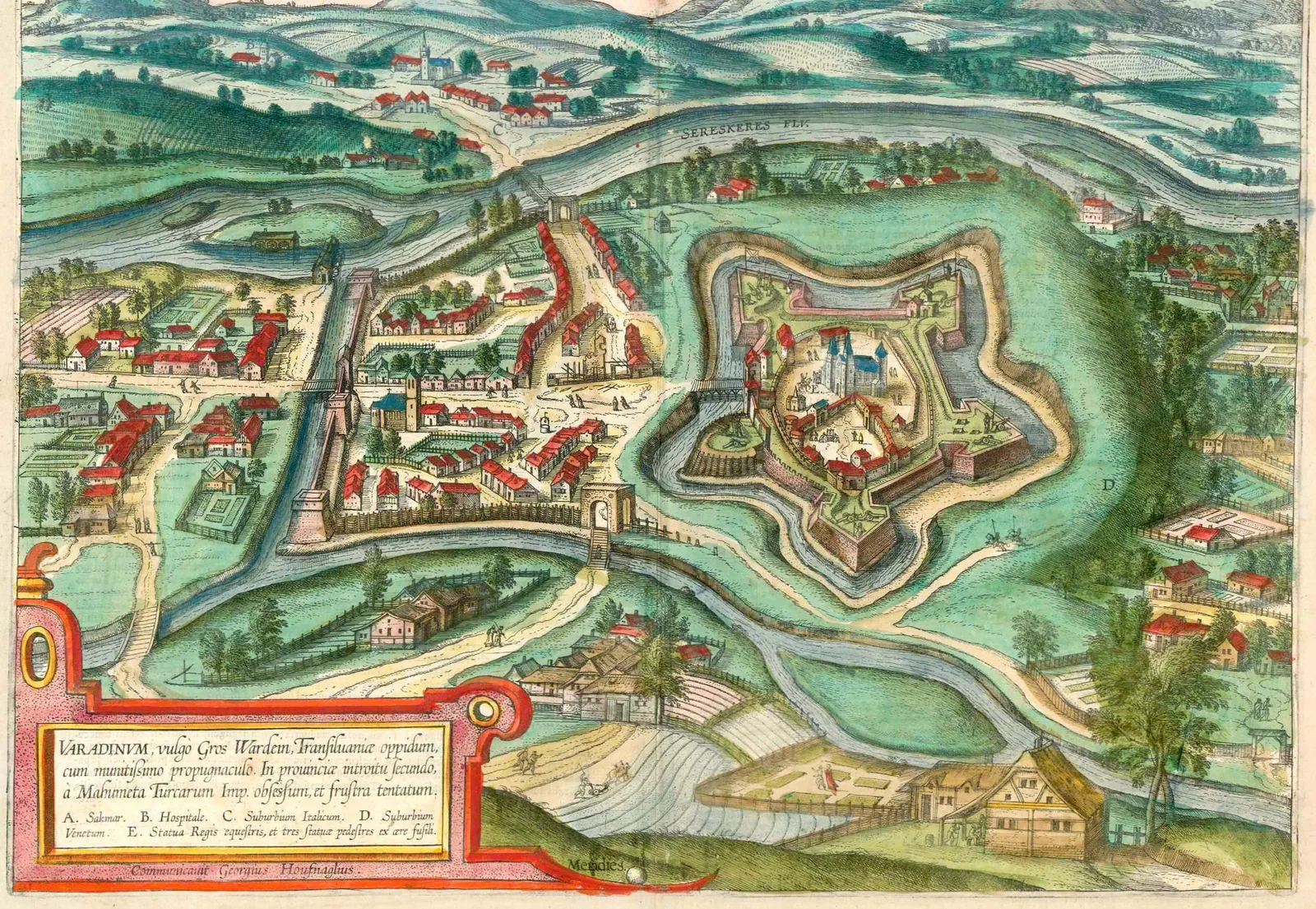
- Joris Hoefnagel, the drawing of Oradea made probably around 1598–1599, engraved in G. Braun and F. Hogenberg, Theatri praecipuarum totius mundi urbium liber VI, Cologne, 1618: the pentagonal fortress with the church inside. gallica.bnf.fr (BnF plate)
The siege and the pashalik, 1660–1692
- Béla Köpeczi (ed.), History of Transylvania / Erdély története: the 14 July camps, the defenders under a thousand, the 44 days, the conditional surrender of August 1660, the Pashalik of Varat, attested in 1662, the 1664 Peace of Vasvár, June 1692. mek.oszk.hu (English) · mek.oszk.hu (Hungarian)
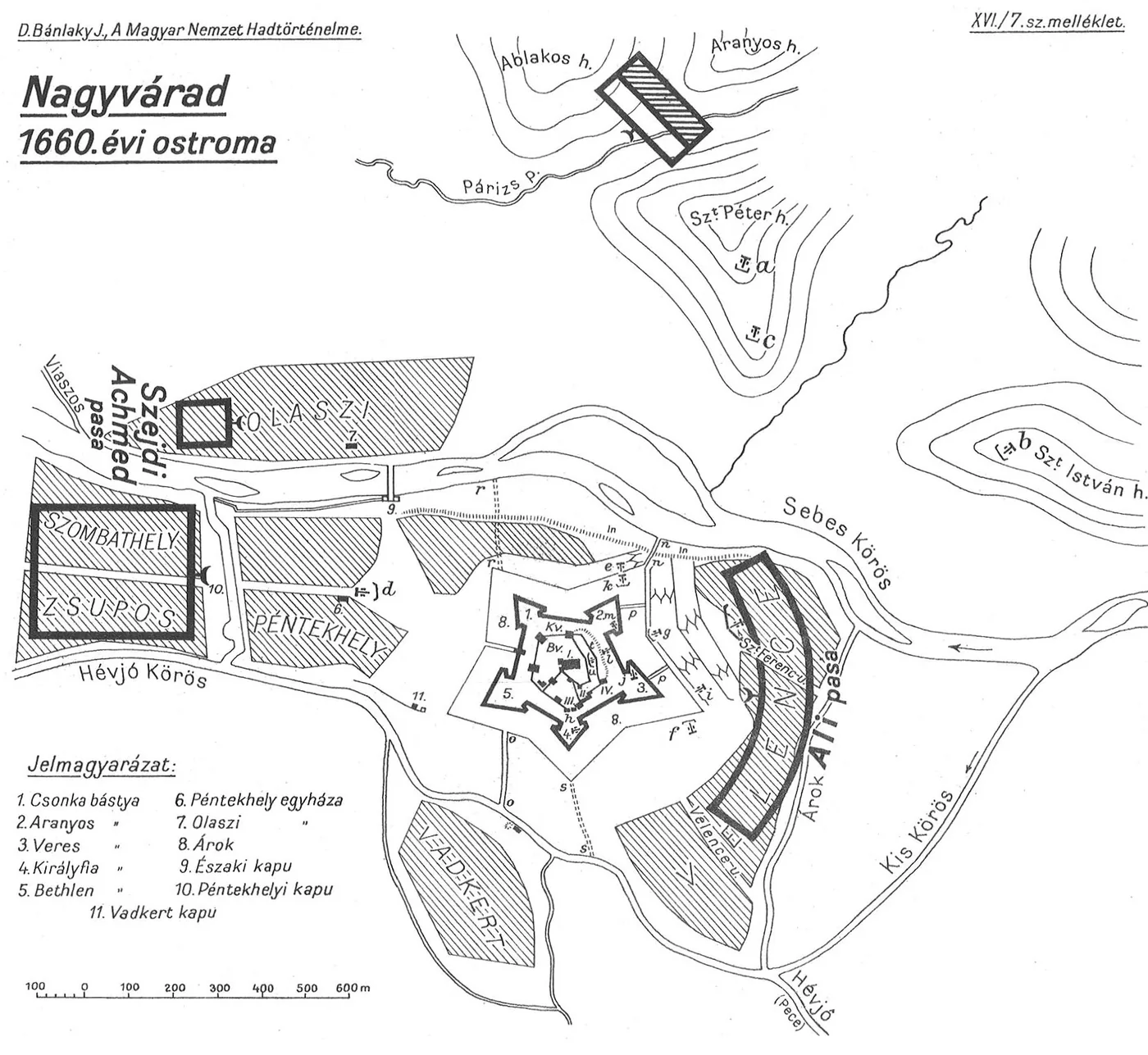
- József Bánlaky, A magyar nemzet hadtörténelme, the “Nagyvárad, the 1660 siege” sketch: the pentagon with numbered bastions, the camps and the scale in metres. mek.oszk.hu
- Gaspar Bouttats, The siege of Oradea, July–August 1660, a 17th-century engraving: the fortress, the burnt town, the batteries and the commanders' quarters. Wikimedia Commons (CC BY-SA 4.0)

The city chronicle
- Oradea City Hall, “Istoric Cetatea Oradea” (in Romanian): 25 September – 3 November 1598, 27 August 1660, 46 days, 32 years of pashalik, 1691–1692, Borgsdorf and the 60,000 florins, the 1725, 1754–1755 and 1775–1777 campaigns, the French prisoners, 1857, the 1947–1952 camp. 2009 archive · 2010 archive · 2013 archive
- The Oradea City Museum, “Vizitează” page: the 19 May 2020 opening, the address, the programme and tariffs — quoted with the December 2022 stamp, the site being no longer online. 2022 archive
Measurement
- The wall circuit: OpenStreetMap, way 190653999 (local survey) — 1,614 metres, 6.25 hectares. openstreetmap.org · Bánlaky's sketch, read at its own scale, shows the same roughly 400-metre object: it confirms the order of magnitude, not the metres. River distances run to the mapped centreline of the channel.
- Day 44 from 14 July falls on 27 August; 1692 minus 1660 is 32; the 1,614-metre round, at 5 kilometres an hour, takes 19 minutes. Every number in the text comes from the data computed with the page.
On mariuscomper.uk
- The chapter on Ottoman Oradea in the history atlas; the star of Alba Carolina and why it is star-shaped; the castles, the road to Trianon, the thermal waters.
Images
- Braun and Hogenberg after Hoefnagel, Varadinum, 1618, public domain. Wikimedia Commons
- József Bánlaky, Nagyvárad, the 1660 siege, from the 1928–1942 series, public domain. Wikimedia Commons
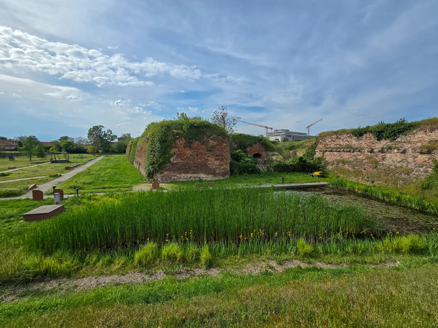
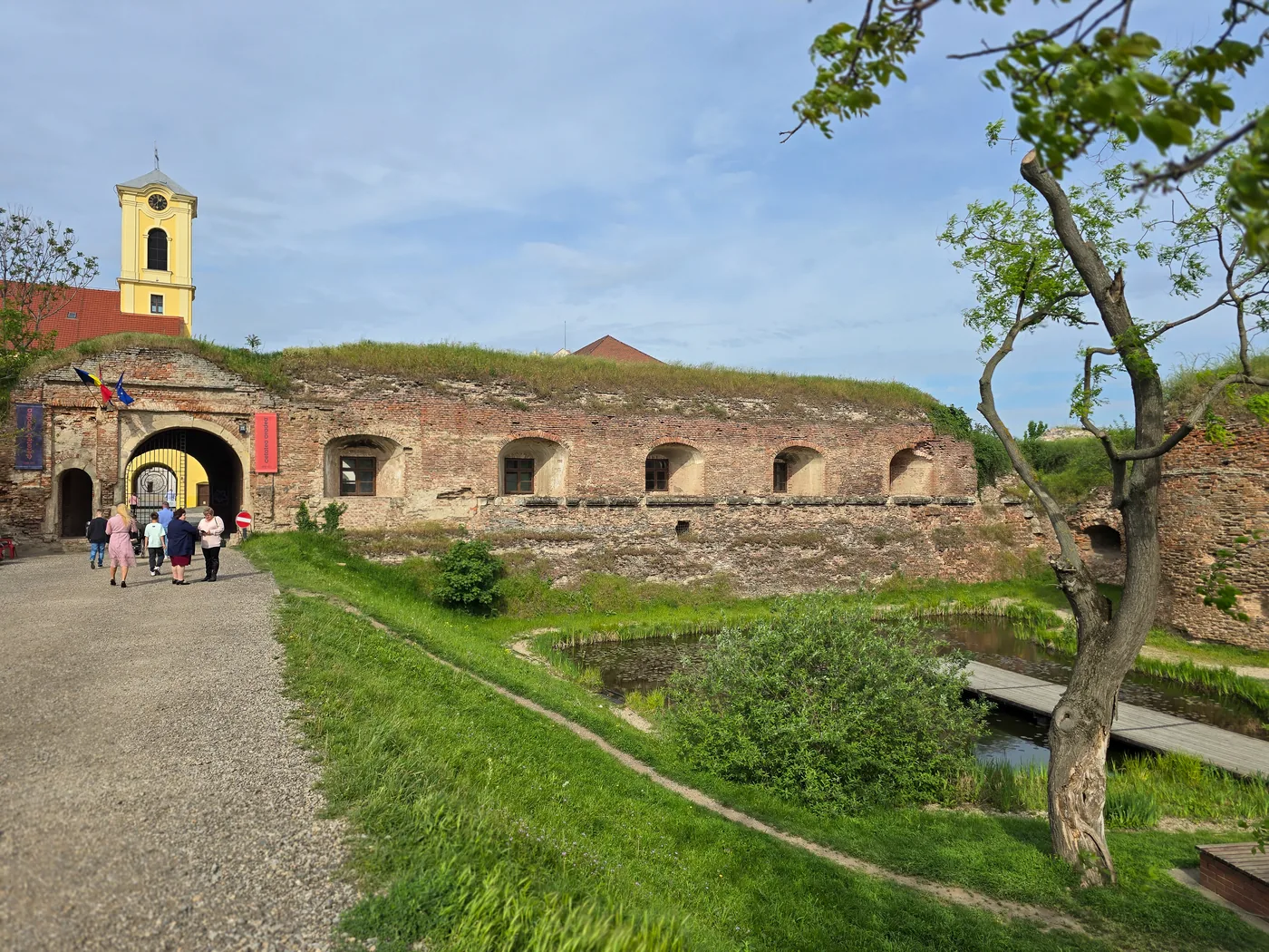
- Photographs of 4 May 2025: Szilas, CC BY 4.0. the courtyard · the Red bastion · the east gate


