The Genoese road, 1261–1484
Who paid for medieval Moldavia?
For two centuries the road from Lviv to the Black Sea carried wax, furs, silk and slaves – and the tolls built a principality. Follow the merchants from the Genoese factories to the Ottoman guns of 1484.
The road in four chapters
Representative route
From Lviv to Caffa
In 1261 Genoa won the Black Sea, and the road from Lviv to its factories began paying Moldavia's way: tolls at Suceava, ships at Cetatea Albă, slaves at Caffa. Below, the road's two centuries – the factories, the toll, the assault – and what stayed.
The routes on the map are representative, drawn through the verified places of the trade. The plates further down are period views and maps.
Chapter I
The factories
1261 – 1359 · 1261–1359, Genoa's Black Sea
- Chapter
- 1261 – 1359
- Nymphaeum
- 1261
- Caffa founded
- 1275
- Caffa falls
- 1475
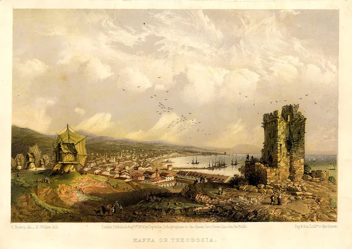
In 1261 the Treaty of Nymphaeum gave Genoa the run of the Black Sea, and the Genoese built an empire of counting-houses: Caffa on the Crimean coast from 1275, a Danube factory at Vicina, an exclave at Maurocastro – a Tatar city, but ruled by the Genoese.
Caffa grew into the largest city in Crimea and Genoa's main Black Sea naval base. Furs and wax came down from Rus', grain, leather, fish and salt from the steppes, spices, incense and silks from the Orient – and slaves, Tatar captives, a growing commodity. At Vicina the Genoese bought cereals, wax, fish and hides, and sold Lombard cloth, linen and spices.
.jpg)

The Bavarian Schiltberger, escaping captivity, saw Caffa at its height: a city by the Black Sea, ringed by two walls, with six thousand houses of Italians, Greeks and Armenians inside one of them. The road that fed it ran west, through the lands that would become Moldavia.
A city called Kaffa, which lies by the Black Sea, and is surrounded by two walls. Within one wall are six thousand houses, in which are Italians, Greeks, and Armenians; it is a chief city on the Black Sea...
Johann Schiltberger, The Bondage and Travels of Johann Schiltberger (Telfer transl., Hakluyt, 1879), ch. 36
Meanwhile Vicina, once the most flourishing Danube port of the Genoese, is lost: its exact site is still debated.
Chapter II
The toll
1359 – 1457 · 1359–1457, the principality cashes in
- Chapter
- 1359 – 1457
- The privilege
- October 1408
- Suceava tolls
- silk and pepper
- Cetatea Albă defended
- 1420
Moldavia hardened into a principality in 1359, when Bogdan I seized the Hungarian border march founded under Dragoș after the Tatars' defeat of 1345. The princes saw at once what crossed their land: in October 1408 Alexander the Good granted the merchants of Lviv regulated free trade across Moldavia, with fixed customs posts from Cernăuți to Cetatea Albă.
The 1408 deeds name Baia, Roman and Bacău among the road's towns; Iași itself is first mentioned in an official document here, in Alexander's grant. Suceava became the main toll centre for silk and pepper, with a Lviv merchants' warehouse confirmed in 1456 and 1460 – and the prince strengthened the ports and the forts guarding the Poland road.


Travellers walked it both ways. Schiltberger came home in 1427 by Kilia, the White City, Suceava, Lviv and Kraków; ten years later the Castilian Pero Tafur stood in Kaffa's slave market, where sellers stripped men and women to the skin and walked them up and down – and bought three slaves himself. In 1420 the Moldavians beat off the first Ottoman attack on Cetatea Albă.
I separated from my companions and joined some merchants, and went with them to a city called in German the White City [Cetatea Albă], then to Sedschoff [Suceava], Limburgch [Lviv], Krackow.
Johann Schiltberger (Telfer transl., 1879), ch. 67; identifications added
In this city they sell more slaves, both male and female, than anywhere else in the world... The sellers make the slaves strip to the skin, males as well as females... and make them walk up and down to show whether they have any bodily defect.
Pero Tafur, Travels and Adventures 1435–1439 (Letts transl., 1926), ch. XVI
Meanwhile Bacău is first attested in the 1408 privilege itself.
Chapter III
The assault
1457 – 1486 · 1457–1486, Stephen's wars
- Chapter
- 1457 – 1486
- Chilia taken
- 24–26 January 1465
- Lipnic
- 20 August 1470
- The ports lost
- 1484
Under Stephen the Great the road became a battlefield. He failed before Chilia in 1462, wounded in the attempt, and took it on 24–26 January 1465 from the Hungarians; in 1470 he crushed a Tatar raid at Lipnic, freeing its captives; in 1472 he privileged the Saxon merchants of Brașov – and in 1473 he stopped the tribute.
The answer came in 1484. Bayezid II struck the two port-forts: his fleet found the Danube channel above Chilia impassable and the cannon were dragged through mud, but after days of bombardment Chilia surrendered in July; the guns went on by sea to Cetatea Albă, which fell in August despite its Polish and German mercenaries. Hadim Ali Pasha raided as far as Suceava to cover the withdrawal.


Stephen fought on – winning at Cătlăbuga in November 1485 and at Șcheia in March 1486 – but the forts stayed lost, and the treaty of 1486 confirmed them Ottoman, with tribute resumed and Moldavian autonomy preserved. The Genoese age on this shore was over; Caffa itself had fallen in 1475.
Meanwhile The 1486 treaty kept Moldavia autonomous – minus its two ports.
Chapter IV
The trace
1486 – 1940 · 1486–1940, what stayed
- Chapter
- 1486 – 1940
- Akkerman register
- 1505
- Towers standing
- 26
- The museum
- 1940
The road did not die with the forts. The Ottoman registers of Caffa (1492) and Akkerman (1505) show shipping and duties continuing, and the Moldavian road – ports, Iași, Suceava, Lviv – stayed the land link of the sea trade, now under new masters.
The stones stayed too. The fortress stands at Bilhorod-Dnistrovskyi on the Dniester estuary, 26 towers still up, on UNESCO's tentative list as Tyras–Bilhorod, 'on the way from the Black Sea to the Baltic Sea'. The town museum, opened in November 1940, covers the Greek layers to the modern ones.

.jpg)
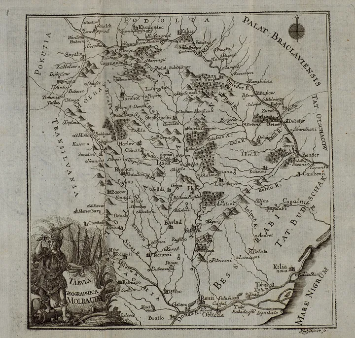
The road's trace runs through Moldavia's towns – Baia, Roman, Bacău, Iași, first named in its charters – and through its maps: Cantemir's 1771 Tabula marks Suceava and Ackerman on the same line the Lviv merchants walked.
Meanwhile The fortress's wartime visiting status could not be verified.
The Genoese quiz
Four questions about the toll, the factories, and the end. Choose, then check against the sources.
-
1
The privilege
In 1408 Alexander the Good granted Lviv merchants:
What happened
Regulated free trade. Fixed customs posts from Cernăuți to Cetatea Albă, a warehouse at Suceava – and tolls that filled the prince's coffers.
-
2
Caffa
The Genoese lost Caffa in:
What happened
1475. The Ottoman conquest ended two centuries of Genoese rule; Chilia and Cetatea Albă followed nine years later.
-
3
The ports
Stephen lost Chilia and Cetatea Albă in:
What happened
1484. Chilia in July, Cetatea Albă in August; his wins of 1485 and 1486 never recovered them.
-
4
The end
The road died with the forts in 1484:
What happened
False. The Caffa (1492) and Akkerman (1505) registers show the duties continuing on the same road.
Answer a card to begin.
Seven plates from the road
Seven period views and maps, in the order of the road: the fortress twice, Caffa, the sea charts, Moldavia mapped, the steppe's dictionary. Tap a plate to study it – or read the whole road straight through.
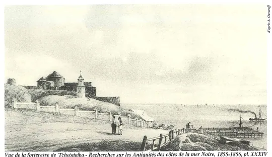
Plate 1856The fortress drawn
The fortress drawn A. Uvarov, 1856 · Wikimedia Commons - Cetatea Albă in 1856, drawn by A. Uvarov: ditches, walls and towers from the land side.
- The stone fortress is Moldavian work – enlarged in 1407, its main elements raised by 1440, 34 towers.
- The Ottomans added their own layer: the Kili gate, the minaret.
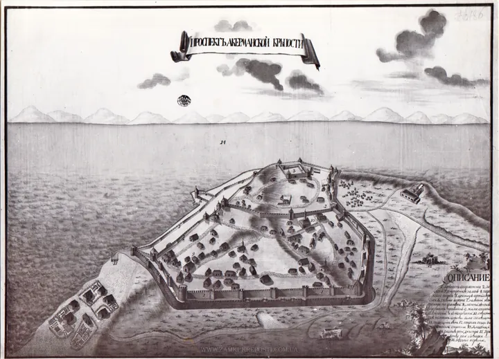
Plate 1770The earliest view
The earliest view 1770 engraving, Russian archive · Wikimedia Commons - Akkerman in 1770: the earliest known view of the fortress, from a Russian archive.
- The Dniester estuary below; the citadel and the outer walls above it.
- 26 towers still stand today.
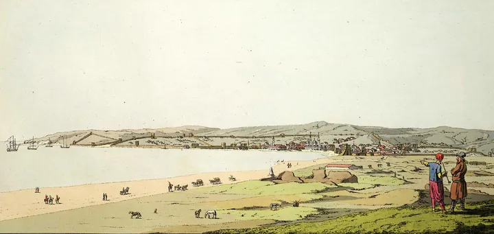
Plate 1788Caffa in ruins
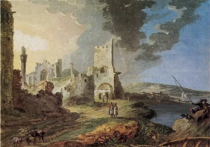
Caffa in ruins De la Traverse, 1788 · Wikimedia Commons - Caffa in 1788, drawn by De la Traverse: Genoese walls five years after the Russian annexation.
- At its height the city held two walls and, by Schiltberger's count, 6,000 houses.
- The slave market Tafur described stood somewhere below these walls.
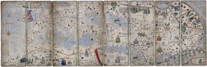
Plate 1375The sea as Genoa knew it
The sea as Genoa knew it Abraham Cresques, 1375 · Wikimedia Commons - The Catalan Atlas of 1375, by Abraham Cresques: the Black Sea trade zone in portolan style.
- Drawn while Vicina flourished and Caffa grew – the road's first century.
- Maurocastro and the Danube mouths sit at its western edge.
Plate 1771Moldavia mapped
Moldavia mapped Dimitrie Cantemir, 1771 · Wikimedia Commons - Cantemir's Tabula Geographica Moldaviae, printed Frankfurt and Leipzig, 1771.
- Suceava, Iași and Ackerman stand on the old road's line – the catalogue's Cantemir page tells the map's story.
- The only period map naming the road's Moldavian towns.
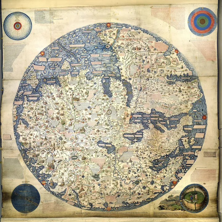
Plate c.1450The world in 1450
The world in 1450 Fra Mauro, c.1450 (1806 copy) · Wikimedia Commons - Fra Mauro's world map, c.1450, in an 1806 copy: the greatest medieval picture of the world.
- The Black Sea fills its corner – Caffa, Tana, the roads to Cathay.
- Drawn a generation before the Ottomans closed the Genoese sea.
Plate 1300sThe steppe's dictionary
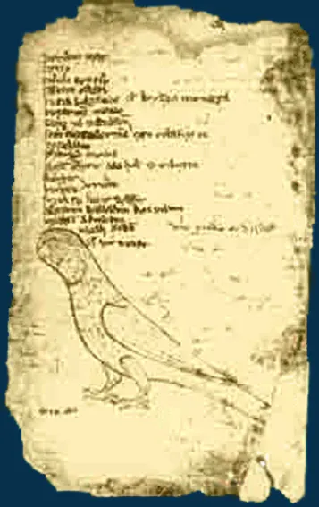
The steppe's dictionary Unknown author, medieval manuscript · Wikimedia Commons - Codex Cumanicus, fourteenth century: a merchant's handbook to the Cuman language of the steppe.
- Latin, Persian and Cuman side by side – the road's working languages.
- Compiled for men like the Genoese factors of Caffa.


Views and maps via Wikimedia Commons (all public domain). Dates are the works' own.
The road in six numbers
Every figure below comes from the cited histories and the travellers' own books. Disputed figures stay out.
- 1,261
- Nymphaeum gives Genoa the Black Sea
- 6,000
- houses inside one Caffa wall, per Schiltberger
- 34
- towers of Cetatea Albă by 1440
- 1,484
- Chilia and Cetatea Albă fall
- 26
- towers still standing
- 1,940
- the town museum opens
Three things people get wrong
Trade founded Moldavia
False: trade predates and enriched the principality, it did not found it. Moldavia began as a Hungarian border march under Dragoș after the Tatars' 1345 defeat; Bogdan I seized it in 1359. The Genoese emporium and the Dniester route are older – Alexander's 1408 privilege monetized them.
The Genoese built Cetatea Albă
Partly false: the factory was Genoese, the fortress is Moldavian. Genoa held Maurocastro as a trading exclave; the stone walls were enlarged in 1407 and raised to 34 towers by 1440, under Stephen II – the Fedorko plate says so. The Ottomans added the Kili gate and the minaret.
The road died in 1484
False: 1484 crippled Moldavia, not the trade. The Ottoman registers of Caffa (1492) and Akkerman (1505) record continuing shipping and duties, and the Moldavian road – ports, Iași, Suceava, Lviv – stayed the sea trade's land link.
Sources and methods
Schiltberger is quoted from the Telfer Hakluyt translation of 1879 (public domain, via Gutenberg); Tafur from the Letts translation of 1926 (public domain). The Romanian renderings are our own.
Disputed dates are given the way the sources can carry them: the privilege as October 1408, Chilia as July 1484, Cetatea Albă as August 1484. The lone 1487 fall date is rejected as an outlier.
Toll rates, honey cargoes, Lannoy's visit and the Tighina staging post are all plausible and all unverified here – so none is claimed.
The factories
- Wikipedia, Bârlad Trail: the Lviv Road, the Przemyśl–Galați stages
- Encyclopedia of Ukraine, Teodosiia: Caffa from 1275, the goods, the fall of 1475
- Wikipedia, Vicina: the Genoese Danube factory; Maurocastrum: Nymphaeum 1261
- J. Schiltberger, Bondage and Travels, Telfer transl., Hakluyt (1879), ch. 36: the 6,000 houses (public domain)
The toll
- Wikipedia, Alexander the Good: the 1408 (Lviv) and 1409 (Kraków) privileges, the customs, the 1420 defence
- JCAA (2023, after Costăchescu 1932): Suceava, the silk-and-pepper toll; Baia, Roman, Bacău in the 1408 deeds
- Schiltberger, ch. 67: the 1427 itinerary (Kilia–Cetatea Albă–Suceava–Lviv–Kraków); P. Tafur, Travels, Letts transl. (1926), ch. XVI: the slave market (public domain)
The assault
The trace
- The Ottoman Caffa (1492) and Akkerman (1505) registers: trade continues; the Moldavian road stays the sea link (Pakucs, via Zenodo)
- The Bilhorod-Dnistrovskyi fortress: 26 towers standing; UNESCO tentative list 6426 (Tyras–Bilhorod, from the Black Sea to the Baltic)
- The companion page in the catalogue: Cantemir's map of Moldavia has its own story
Images
- A. Uvarov, 1856 · Wikimedia Commons
- 1770 engraving, Russian archive · Wikimedia Commons
- De la Traverse, 1788 · Wikimedia Commons
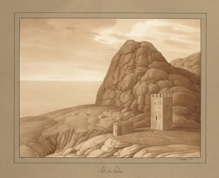
- Carlo Bossoli / Edmund Walker, 1856 · Wikimedia Commons
- Abraham Cresques, 1375 · Wikimedia Commons
- Fra Mauro, c.1450 (1806 copy) · Wikimedia Commons
- Dimitrie Cantemir, 1771 · Wikimedia Commons
- Karl von Kügelgen, 1824 · Wikimedia Commons
- G. H. Geissler, 1793–94 · Wikimedia Commons
- Unknown author, medieval manuscript · Wikimedia Commons