Chapter 5 · Atmosphere and climateLesson 5.2
Climate factors and elements: why two places at the same latitude have different climates
Why is Vârful Omu 14 °C colder than Bucharest when the Sun rises almost as high above both?
Before you read: what do you think?
Constanța is on the coast, Bucharest in the middle of a plain. Where does more precipitation fall in a year?
See the answer
In Bucharest; Constanța gets almost a third less. Bucharest gets 612 mm a year and Constanța 432 mm. The sea makes winters milder on the coast, but heavy rain falls where moist air is forced to rise: Vârful Omu gets 991 mm.
Bucharest and Vârful Omu, a mountain summit, are just one degree of latitude apart. The average annual temperature is 11.8 °C in Bucharest and −2.1 °C on Omu. Constanța, also at Bucharest’s latitude, has milder winters and almost a third less precipitation.
A factor is a cause; an element is what is measured
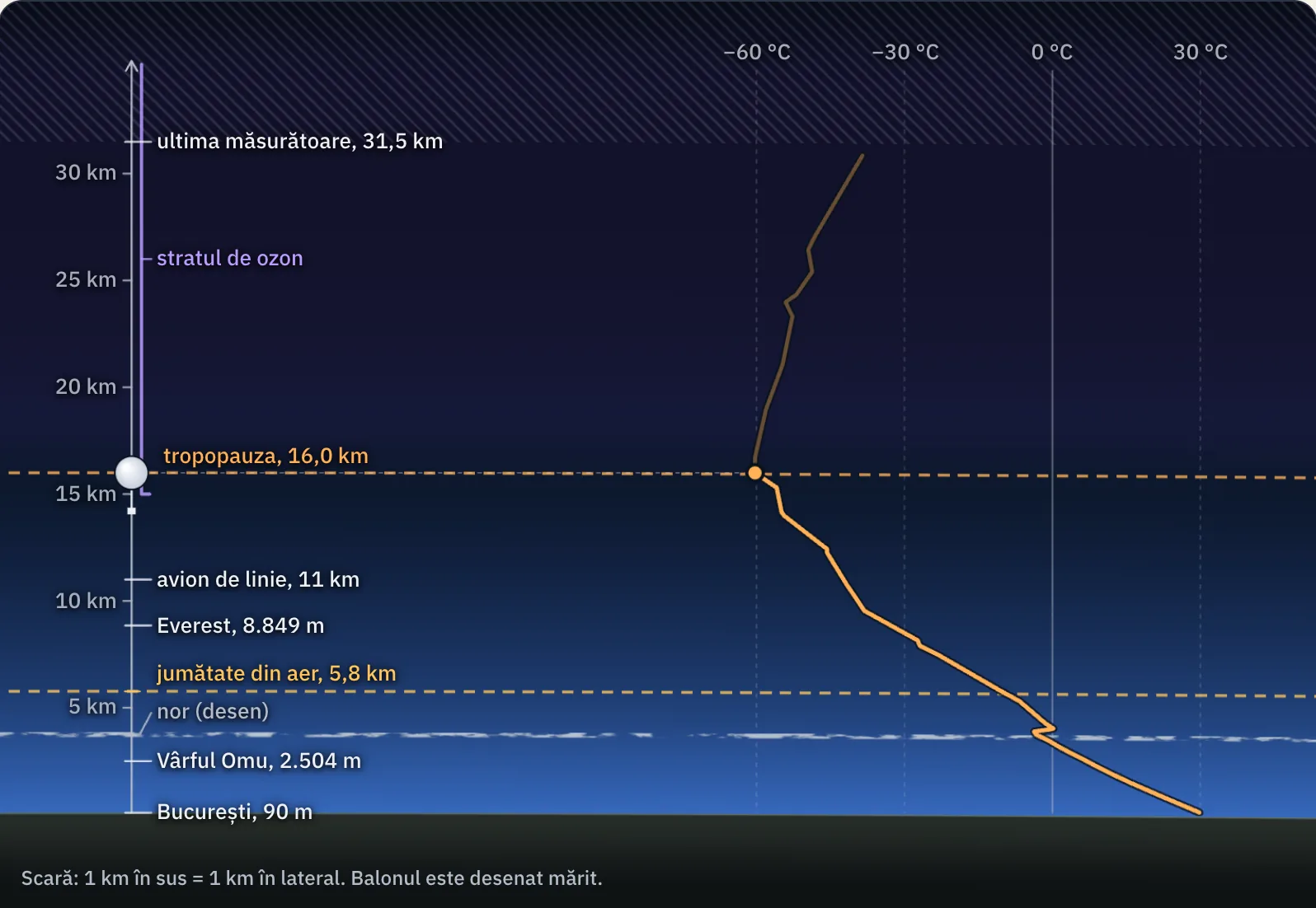
Bucharest and Vârful Omu receive almost the same solar radiation because they are at almost the same latitude. The 14 °C difference comes from altitude: the station on Omu is 2,422 m higher, and in the troposphere the air gets colder as you climb. Altitude is a factor; the temperature of −2.1 °C on Omu is an element.
Climate elements are the quantities measured at a weather station: air temperature, atmospheric pressure, wind, humidity, cloud cover and precipitation. Climate factors are the causes that give these elements their values: solar radiation, the general circulation of the atmosphere, the active surface and human activity.
Weather is the state of the atmosphere at a place and time. Climate is the long-term pattern of weather at that place, described by averages calculated over at least 30 years, for example 1991–2020.
Solar radiation decreases from the Equator towards the poles
The energy source for climate is solar radiation. Near the Equator, rays strike almost vertically and heat the surface strongly. Towards the poles they strike at an increasing slant, spreading the same energy over a larger area. That is why average temperature falls with latitude and the planet has one hot zone, two temperate zones and two cold zones.
For the curious
Some radiation is sent back into space. Snow and ice reflect most of the light, while the ocean and forests retain most of it.
The general circulation of the atmosphere moves heat and rain
At the Equator, heated air rises, leaving a zone of low pressure at the surface, with frequent rain. Air sinks around latitude 30°, forming high-pressure zones with clear skies; the great deserts lie here. At the surface, wind blows from high towards low pressure, and Earth’s rotation deflects it to the right in the Northern Hemisphere and to the left in the Southern Hemisphere.
This is how permanent winds arise. Trade winds blow from 30° towards the Equator, from the north-east in the Northern Hemisphere and from the south-east in the Southern Hemisphere. Westerlies blow between 30° and 60° latitude and bring moist Atlantic air over Europe. Polar winds blow from the east, carrying cold, dry air from the poles towards lower latitudes.
Monsoons are periodic winds that change direction with the seasons. In summer, the Asian landmass heats up more than the ocean and the monsoon blows from the ocean, bringing very heavy rain to India and South-East Asia. In winter it blows from the land and brings the dry season.
The active surface: ocean or land, plain or mountain
The active surface is the Earth’s surface where solar radiation is transformed into heat: land or water, forest, sand or ice. Water heats up and cools down more slowly than land. Near the ocean, summers are cool, winters mild and rainfall abundant; in continental interiors, the difference between summer and winter grows and precipitation decreases.
Landforms alter climate through altitude and the position of mountains. In the troposphere, temperature falls by an average of approximately 6.5 °C for every 1,000 m of ascent: this is the vertical temperature gradient. When moist air is forced up a slope, it cools, water vapour condenses and rain falls. On the opposite slope the air descends dry and warms up.
Warm ocean currents carry heat from the tropics towards high latitudes. Cold currents cool the coasts they pass.
The human factor is human activity. Burning coal, oil and gas adds greenhouse gases to the atmosphere.
For the curious
The Gulf Stream, followed by the North Atlantic Current, is a warm current: it makes winters in western Europe milder.
People also change climate on a small scale: cities are warmer than the surrounding countryside, and deforestation changes air humidity.
Climate elements depend on one another
Warm air is lighter and exerts less pressure, producing low pressure; cold air produces high pressure. A difference in pressure sets air in motion: this is wind, described by the direction it blows from and by its speed.
Warm air can hold more water vapour than cold air. When moist air cools, the vapour condenses and forms clouds. Cloud cover shows how much of the sky is covered by clouds. Precipitation is measured in millimetres: 1 mm means one litre of water per square metre.
For the curious
Air temperature is measured in degrees Celsius, in the shade, inside a weather shelter.
Worked example
The temperature gradient between Bucharest and Vârful Omu
Bucharest-Filaret station is at an altitude of 82 m and has an average annual temperature of 11.8 °C. Vârful Omu station is at 2,504 m and has a temperature of −2.1 °C. Both values are averages for 1961–2024.
The altitude difference is 2,504 − 82 = 2,422 m. The temperature difference is 11.8 − (−2.1) = 13.9 °C. The ratio is 13.9 °C ÷ 2.422 km = 5.7 °C per 1,000 m, a little below the average value of 6.5 °C. The two stations are not in the same column of air, so the result illustrates the effect of altitude without measuring the gradient exactly.
The rule works in reverse too. If a city at 300 m is at 24 °C on a summer day, what would you expect on a ridge at 1,800 m, 1,500 m higher? The calculation is 24 − 1.5 × 6.5 = 14.25, or approximately 14 °C.
In Romania
The sea, the mountains and four local winds
Constanța and Bucharest receive almost the same solar radiation, but in Constanța the sea makes winter milder: the January average is 1.3 °C, compared with −0.9 °C at Bucharest-Filaret. The coast is also drier, with 432 mm of precipitation a year, compared with 612 mm in Bucharest. On Vârful Omu, where moist air is forced to rise, 991 mm falls.
The crivăț, a local wind, blows from the north-east in winter across Moldova, Bărăgan and Dobrogea; it is cold and strong and sweeps up snow. The austru, another local wind, blows from the south-west in Oltenia and Banat; it is dry and brings drought. The foehn is a warm, dry wind that descends the sheltered side of a mountain and speeds up snowmelt. Breezes change direction between day and night: on the coast, they blow from sea to land by day and from land to sea at night.
In brief
- Weather is the state of the atmosphere at a given time; climate is the long-term pattern of weather, described by averages over at least 30 years.
- Climate factors are solar radiation (which decreases with latitude), the general circulation of the atmosphere, the active surface (ocean or land, landforms, ocean currents) and the human factor.
- Climate elements are air temperature, atmospheric pressure, winds, humidity, cloud cover and precipitation.
- Permanent winds are the trade winds (from 30° towards the Equator), westerlies (between 30° and 60°) and polar winds; monsoons are periodic winds, wet in summer and dry in winter.
- Temperature falls with altitude by an average of approximately 6.5 °C per 1,000 m: the vertical temperature gradient.
- Local winds in Romania include the crivăț (north-east, winter), austru (south-west, dry), foehn (warm, descends from the mountains) and breezes.
Common mistakes
WrongTwo places at the same latitude have the same climate.
RightLatitude determines only how much solar radiation a place receives. Altitude, distance from the ocean, ocean currents and prevailing winds can greatly change temperature and precipitation.
WrongAltitude and proximity to the sea are climate elements.
RightThey are factors: they act as causes. Climate elements are the measured quantities: temperature, pressure, wind, humidity, cloud cover and precipitation.
WrongThis winter was freezing, so the climate has cooled.
RightOne winter belongs to weather. Climate is judged by averages over at least 30 years.
Test yourself
Six questions. For the first five you see the explanation at once, with the paragraph of the lesson that supports it; for the ones with a written answer you compare with a good answer.
Which of the following is a climate factor?
Answer
c) The general circulation of the atmosphere. The general circulation of the atmosphere acts as a cause. The other three are climate elements, or measured quantities.
From which direction do trade winds blow in the Northern Hemisphere?
Answer
a) From the north-east, towards the Equator. Trade winds leave the high-pressure zones at 30° and Earth’s rotation deflects them to the right, so they reach the Equator from the north-east.
Why does Constanța have milder winters than Bucharest, although they are at almost the same latitude?
Answer
d) Because seawater cools more slowly than land. The sea retains summer heat and releases it in winter, so the air on the coast cools less.
What does the summer monsoon bring to India?
Answer
b) Very heavy rain from the ocean. In summer, land heats up more than the ocean, and the monsoon blows from the ocean, laden with water vapour.
At 300 m altitude the temperature is 18 °C. What temperature would you expect at 2,300 m if temperature falls by 6.5 °C per 1,000 m? Give your answer in degrees Celsius.
°CAnswer
5 °C. The altitude difference is 2,000 m, so the temperature falls by 2 × 6.5 = 13 °C: 18 − 13 = 5 °C.
Two cities are at the same latitude and altitude. One is an Atlantic port in western Europe; the other is in the middle of the continent, 2,000 km from the coast. How do their climates differ, and why?
A good answer
The port has cool summers, mild winters and abundant precipitation because ocean water heats up and cools down slowly, and the westerlies bring moist air from the Atlantic. The inland city has warmer summers, colder winters and less precipitation because land heats up and cools down quickly, and ocean air reaches it after losing much of its moisture.
A complete answer compares summer and winter temperatures and precipitation, and names two factors: the active surface (ocean or land) and the westerlies.
Terms
- climate
- The long-term pattern of weather in a place, described by averages calculated over at least 30 years.
- climate factors
- The causes that give rise to climate: solar radiation, the general circulation of the atmosphere, the active surface and human activity.
- climate elements
- The quantities used to describe weather and climate: temperature, pressure, wind, humidity, cloud cover and precipitation.
- trade winds
- Permanent winds that blow from latitude 30° towards the Equator, from the north-east in the Northern Hemisphere and from the south-east in the Southern Hemisphere.
- monsoon
- A periodic wind that blows from ocean to land in summer, bringing heavy rain, and from land to ocean in winter.
- vertical temperature gradient
- The decrease in air temperature with altitude, averaging approximately 6.5 °C per 1,000 m.
- cloud cover
- The extent to which the sky is covered by clouds.
Sources and link to the programme
- ANM – Caracterizare climatologică multianuală 1961–2024, ianuarie (tabelul 2; celelalte luni au pagini cu aceeași adresă, terminate în _02 … _12) – long-term monthly average temperatures and precipitation at Bucharest-Filaret, Constanța and Vârful Omu, from which annual averages and totals are calculated
- NOAA NCEI – GHCN-Daily, lista stațiilor – altitude and latitude of the Bucharest-Filaret (82 m; 44.42° N), Constanța (13 m; 44.22° N) and Vârful Omu (2,504 m; 45.45° N) stations
- WMO – Climatological normals – standard climate normals calculated over 30 years (1991–2020)
- NOAA JetStream – Global atmospheric circulations – circulation cells, pressure zones at the Equator, 30° and the poles, westerlies and polar winds
- NOAA National Ocean Service – What are the trade winds? – trade winds and their direction
- UCAR Center for Science Education – Monsoons – monsoons and the seasonal change in wind and rainfall
- NOAA Ocean Exploration – How does the ocean affect climate and weather on land? – the role of the ocean and ocean currents in the climate of land
- UCAR Center for Science Education – The troposphere – the decrease in temperature with height in the troposphere
- Met Office – Foehn effect – the foehn: warmer, drier air on the sheltered side of a mountain
- NOAA JetStream – The sea breeze – sea and land breezes
- dexonline – crivăț – the crivăț: a strong, cold winter wind from the north-east in Moldova and the Danube Plain
- dexonline – austru – the austru: a drought-bearing wind from the south-west
From the programme: “Climate factors. Climate elements” (common core). Programme competences covered: 1.3, 2.3, 3.3.