Chapter 6 · The hydrosphere: a dynamic system
Where does the rain that falls on your street end up?
Clock: a flood and a yearScale: from the school yard to the Black Sea
The terrain beside you was measured from satellite, and the rivers are drawn on it in blue. Touch it anywhere to trace the route rainwater would follow from that spot, valley by valley, down to the sea. The route is calculated from the terrain.
Two drops fall one kilometre apart
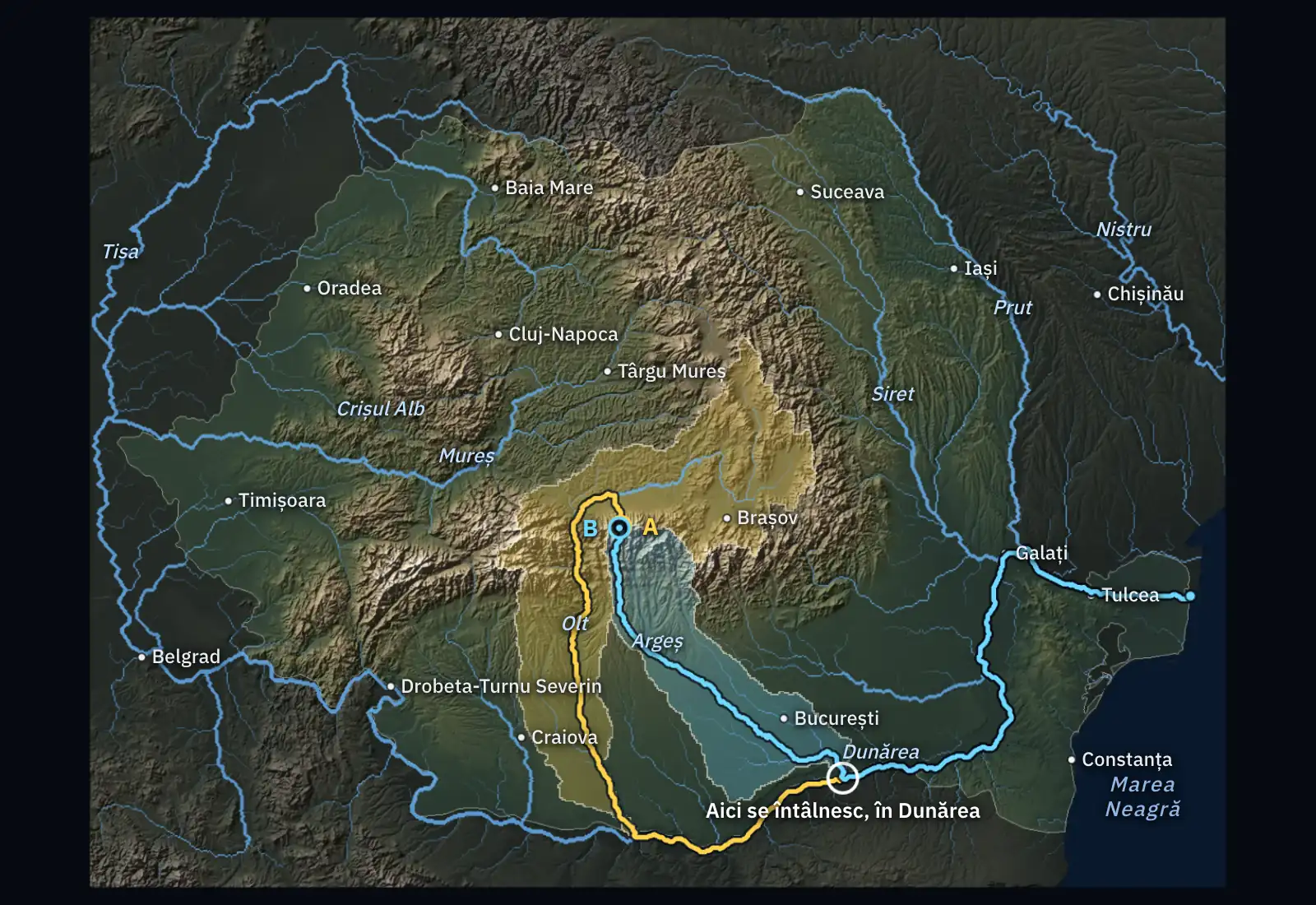
On a ridge in the Eastern Carpathians, between the sources of the Mureș and those of the Olt, it rains. Drop A falls on the western slope, at 1,500 m. Drop B falls on the eastern slope, one kilometre from the first.
Will the two drops meet again on their way?
From the Făgăraș ridge to the sea, the water travels 910 km
A drop falls at 2,230 m, on the northern slope of the Făgăraș Mountains. Water always runs towards the lowest neighbouring spot: it goes down the slope, reaches a stream, then the Olt.
The Olt is a tributary of the Danube, and the place where they meet is a confluence. From there the drop travels with the Danube to the mouth, through the Sulina branch, into the Black Sea. The whole route is about 910 km.
The ridge sends rain towards the Olt or the Argeș
A second drop falls 1.4 km from the first, on the other side of the ridge. It runs south and reaches the Argeș.
The line along the crest that divides the waters is the watershed. The whole area from which a river collects its water is the river’s drainage basin. The two coloured areas are the basin of the Olt and the basin of the Argeș, and the pale line between them is the watershed.
The two drops meet in the Danube, at the mouth of the Argeș: the first after 480 km, the second after 320 km.
Neighbours on the ridge, the drops meet after 1,500 km
Drop A runs down into the Mureș, passes into the Tisa and reaches the Danube in Serbia. Drop B runs down into the Olt and reaches the Danube in southern Romania.
They meet in the Danube, at the mouth of the Olt: A after about 1,500 km, B after 610 km. From there they travel another 590 km together to the sea.
One kilometre on the ridge made a difference of 890 km in the route. The watershed decides which river the rain ends up in.
From Cluj-Napoca to the sea is 2,210 km by river, four times the straight-line distance
Rain that falls at Cluj-Napoca reaches the Someșul Mic, then the Someș, then the Tisa. The Tisa carries it through Hungary and Serbia, where it flows into the Danube. The Danube brings it back: first along Romania’s border, then through the Danube Delta.
In a straight line, from Cluj-Napoca to Sulina it is 500 km. By river, the route is about 2,210 km and passes through or beside five countries: Romania, Hungary, Serbia, Bulgaria, Ukraine.
Rivers pay no attention to borders. What gets into the water upstream, higher up the river, can reach the people downstream.
Over 97% of Romania’s area sends its water to the Danube
Each colour is the drainage basin of a tributary of the Danube, and the pale lines are watersheds. The largest basin on Romanian territory is that of the Siret, at about 43,000 km².
The basin of the Tisa is split by its large tributaries in Romania: Mureș, Someș, Crișuri, Bega. Their water joins the Tisa only beyond the border.
Only about 2% of the country, a strip of Dobruja, sends its water straight into the Black Sea. Romania manages its waters by drainage basin, through 11 regional water authorities.
Where the rain from your street ends up
Touch the terrain where you live: from there a drop starts. If you have chosen your town, the drop falls there.
Read the route: which river it reaches first, which rivers it passes through, how many kilometres it travels and how many metres it descends. Then let a drop fall on the other side of the nearest hill and see whether it reaches the same river.
The route shows where the water flows at the surface. It does not show how much water comes or when: part of the rain evaporates, part sinks into the soil, and reservoirs hold it back for a while.
Now you explain
It is raining hard at Baia Mare. Without touching the relief, say: which rivers does the water pass through on its way to the sea, through which countries, and who receives it downstream? Explain using the drainage basin and the watershed.
The lesson on inland waters: the river from source to mouth, the drainage basin and the discharge