The whole street, in words
The 14 stops of the walk, in the order of the street. Those of 1974 separate what is on the plan, what is in photographs and what is assumed; those of today also give the margin with which the plan is laid over the city.
Four materials, four ways of knowing
- Paper and inkwhat is drawn on the 1974 cadastral plan
- Black-and-white photographwhat photographs of the street show
- Watercolourwhat is assumed, from the kind of house the quarter had
- Full colourwhat can be seen on the spot today
What stood on the hilltop, at the Maior Ene corner?
1 Drawn on the plan
The corner with Strada Maior Ene, at 87.65 metres
- On the planThe edges of the street, a ticked line along it, the outline of every building, house numbers and a point marked 87.65.
- In photographsNothing, at this step.
- AssumedNothing, at this step.
This is the upper end of the walk. The cadastral plan of Bucharest, drawn at 1:2000 around 1974, puts a point here at 87.65 metres above sea level. Strada Izvor, at the bottom, is 450 metres away, and the street drops 11 metres on the way.
The first step of the handle shows the shapes, numbers and heights read from the plan. The second adds, in black and white, what can be recognised in photographs. The third adds, in watercolour, what is assumed. The last shows the place today. Here, at the first, every building outline is raised to one metre, because the plan gives the shape of a house on the ground and does not say how tall it was. Hatched buildings are those the plan marks as built before 1945; white ones are newer.
The numbers on the plates and the heights on the staffs are copied from the plan, at the places where it prints them.
2 Where knowledge stops
Number 36: a single-storey house known only from the plan
- On the planThe outline, on the northern corner of the crossing, and the number 36 written in its yard.
- In photographsA single-storey shop front on this corner, in a photograph of June 1980 by Gheorghe Parusi. The caption gives no house number.
- AssumedNothing. The house remains an outline.
Uranus Acum, the project that rebuilt the history of the quarter from archives and from former residents' memories, looked for this house and wrote: “Besides the shape of the plan and the fact that it was a single-storey building, we know nothing about this house.”
So the house stands here with one storey, no roof and no colour, however far the handle is pushed. A photograph Andrei Bîrsan took during the demolitions shows number 38, a two-storey building with a rounded corner, at the Maior Ene corner. On the plan, the number 36 is written in the yard on the opposite corner.
In 2019 Uranus Acum set up, beside the entrance steps of the National Museum of Contemporary Art, a wire silhouette of a casă-vagon (a long, narrow “wagon house” with its short side to the street) as a marker for number 36.
Sources
- Cadastral plan of Bucharest, central area, scale 1:2000, about 1974 (DocuBucurești collection, Idei Urbane)
- Uranus Acum, leaflet of the public-space installations, 2019, p. 2 (archived copy)
- Bucureștii vechi și noi, “Uranus – o stradă pentru eternitate”, 2010 (with Gheorghe Parusi's photograph of June 1980)
- Bucureștii vechi și noi, the corner of Uranus and Maior Ene during the demolitions (photo: Andrei Bîrsan)
- Scena9, “Uranus atunci, Uranus acum” (on the Uranus Acum exhibition at MNAC)
- Zeppelin, “Uranus Now”: exhibition, digital archive and public-space installations, MNAC, 17.10.2019–12.01.2020
3 Assumed
Numbers 26 and 28: what they looked like is not known
- On the planLong, narrow outlines with the short side to the street, the numbers 26 and 28, and the hatch of buildings older than 1945.
- In photographsNothing. No photographs were found of the houses at numbers 18, 20A, 22, 26, 28 or 36.
- AssumedWalls, the pitched roof, windows, door, colour, fence, chimneys.
A long, narrow outline with its end to the street is that of the casă-vagon, the “wagon house” that Uranus Acum calls typical of Strada Uranus. That is all that can be said. The assumed houses here share one height, one set of windows and one door, so that they read as a kind of house and not as anyone's house. The colours are chosen.
Photographs show the street was more than that. At number 32, a photograph of the early 1940s catches a white modernist block with a shop on the ground floor. On the plan its number cannot be read with certainty beside any outline, so the block is not drawn.
Behind the first row the scanned plan no longer separates one house from the next. There the roofs are divided schematically, every 11 metres.
4 Seen in photographs
The tram and the setts
- On the planA line with cross ticks, drawn along the street.
- In photographsA double tram track in stone setts with the contact wire above (1970s, Traian Bădulescu); tram 7 at the “Maior Ene” stop in the early 1940s; a raised kerb and trees on both pavements.
- AssumedWhere the poles and the trees stood.
The second step adds what photographs of this street show, in black and white, like them. The setts, the rails and the wires are in photographs; their shape and place are approximate, and their colour is not there to see.
According to the site Bucureștii vechi și noi, trams of lines 2, 3, 8, 20 and 25 ran here. A photograph caption from the time of the demolitions says the tracks had been taken out of use and the routes moved to Strada Izvor.
The ticked line on the plan roughly follows the route of the rails in the photographs.
Sources
- Cadastral plan of Bucharest, central area, scale 1:2000, about 1974 (DocuBucurești collection, Idei Urbane)
- Bucureștii vechi și noi, the Firefighters' Monument, 1970s (photo: Traian Bădulescu sr.)
- Bucureștii vechi și noi, the tram stop at Maior Ene, early 1940s
- Bucureștii vechi și noi, “Uranus – o stradă pentru eternitate”, 2010 (with Gheorghe Parusi's photograph of June 1980)
- Bucureștii vechi și noi, the corner of Uranus and Maior Ene during the demolitions (photo: Andrei Bîrsan)
What stood in front of the Arsenal?
5 Drawn on the plan
From 87.16 to 83.01: the street begins to fall
- On the planThe heights 87.16, 85.94 and 83.01, and Strada Fonteriei coming up from the left.
- In photographsNothing new.
- AssumedNothing.
So far the street has been almost level: 87.65 metres at the Maior Ene corner, 87.16 here. From here it falls. About 50 metres further down the plan prints 85.94, and at the mouth of Strada Fonteriei, 83.01.
The caption of a photograph from the early 1940s says the same in words: from the Maior Ene stop the street “began to drop more and more steeply”.
The reddish lines on the paper are contour lines, one for every metre. They are recomputed from the plan's heights, not copied from it.
6 Seen in photographs
The firefighters' monument, in the fork of the streets
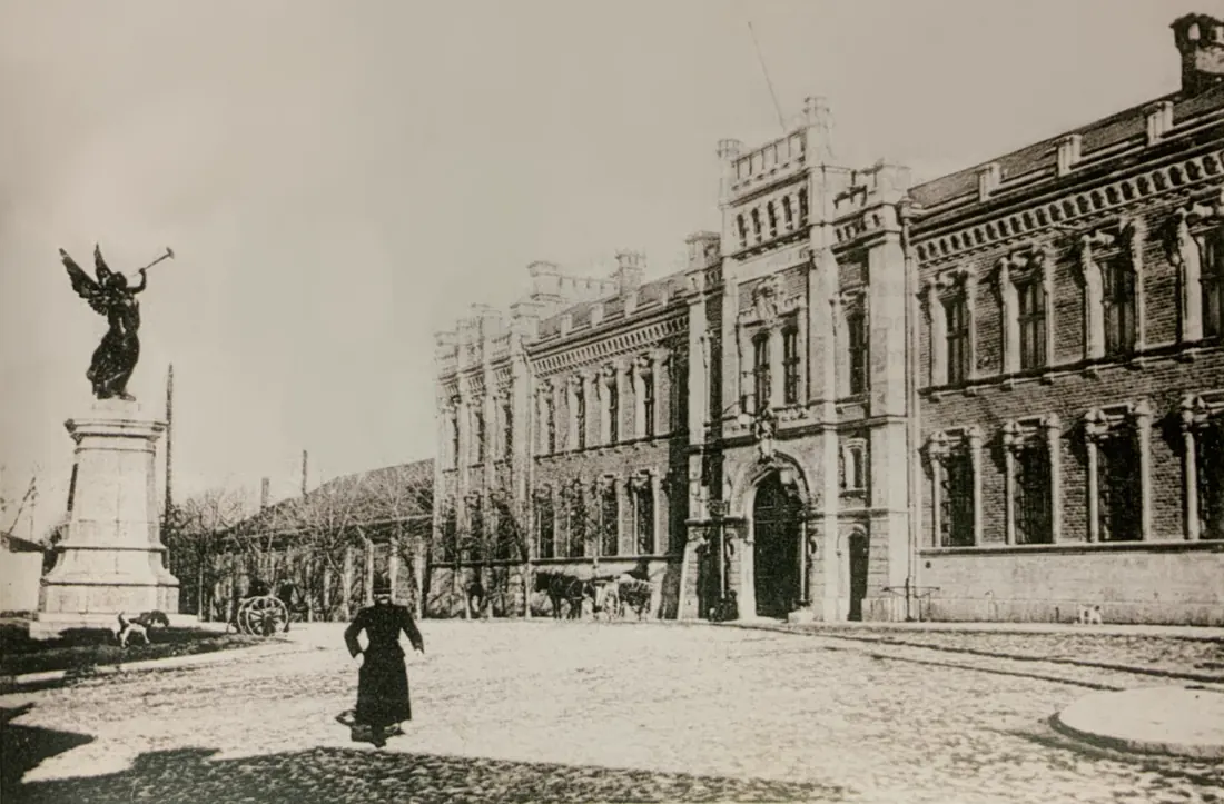

- On the planThe island in the fork of Uranus and Fonteriei, with a square sign in the middle.
- In photographsA tall stone pedestal with a bronze figure on top, on a kerbed island (postcard from after September 1901; photographs of 1906 and the 1970s).
- AssumedThe shape of the figure, shown here only as a block.
The Firefighters' Monument was unveiled here on 13 September 1901, in front of the Arsenal. It recalls the battle of Dealul Spirii (Spirii Hill) of 13 September 1848, when the city's fire company fought Ottoman troops. It was taken down in 1984 and moved in 1990; today it stands where Calea 13 Septembrie meets Strada Izvor.
Strada Fonteriei came up from the left and met Uranus right at the statue. Before the monument, a pyramid of cannon barrels had stood on the same spot.
Sources
- Cadastral plan of Bucharest, central area, scale 1:2000, about 1974 (DocuBucurești collection, Idei Urbane)
- Postcard of the Arsenal and the Firefighters' Monument, after 1901 (Wikimedia Commons)
- Bucureștii vechi și noi, the main front of the Arsenal, 1906 (photo: Chusseau-Flaviens)
- Bucureștii vechi și noi, the Firefighters' Monument, 1970s (photo: Traian Bădulescu sr.)
- Alexandru Popescu, “Casele Bucureștilor (XXXVII)”, Ziarul de Duminică
- Romanian Wikipedia, “Monumentul Eroilor Pompieri din București”
- Uranus Acum, “Locuri ale memoriei” (archived copy)
- Bucureștii vechi și noi, the main entrance of the Arsenal with the earlier monument at the Uranus–Fonteriei fork
7 Seen in photographs
The main building of the Arsenal
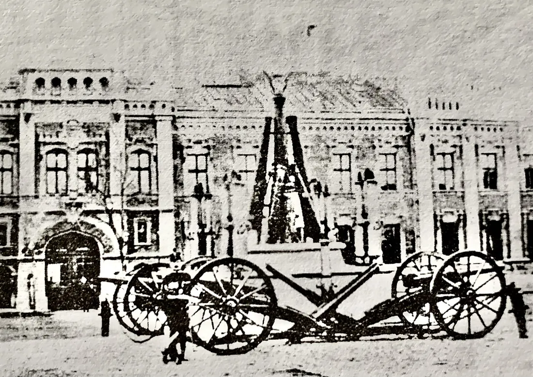

- On the planA hatched outline 56 metres long, on the right-hand side, and the precinct wall, drawn as a double line.
- In photographsTwo storeys of brick on a stone plinth, paired windows, battlements and a gate tower with a pointed arch (postcard from after September 1901; photograph of 1906).
- AssumedThat it looked the same in 1974. The colour of the brick.
The main building and gate of the Army Arsenal were finished in 1861, writes the historian Emanuel Bădescu. The photographs it is raised from here are some 70 years older than the plan. A photograph of the 1970s has it, according to its caption, “at the far right of the picture”: the building was still standing, but what it looked like then cannot be seen.
Not much was left behind the wall. The caption of a 1976 photograph describes the precinct: a few old sheds, a few tanks, a water tower and, for the rest, a wide concrete platform. The plan labels it “Întrepr. construcții edilitare drumuri”, a municipal road-building enterprise.
A 1984 photograph by Andrei Bîrsan shows the Arsenal partly demolished.
Sources
- Cadastral plan of Bucharest, central area, scale 1:2000, about 1974 (DocuBucurești collection, Idei Urbane)
- Plan of the city of Bucharest, official edition 1911, scale 1:5000, Army Geographical Service (Wikimedia Commons, public domain)
- Postcard of the Arsenal and the Firefighters' Monument, after 1901 (Wikimedia Commons)
- Main building and gate of the Arsenal, old photograph (Wikimedia Commons)
- Bucureștii vechi și noi, the main front of the Arsenal, 1906 (photo: Chusseau-Flaviens)
- Emanuel Bădescu, “Bucureștiul neogotic (III)”, Ziarul de Duminică, 12 December 2013
- Bucureștii vechi și noi, the Firefighters' Monument, 1970s (photo: Traian Bădulescu sr.)
- Bucureștii vechi și noi, the Arsenal precinct wall seen from Strada Militari, 1976 (photo: Radu Ștefănescu)
- Mara Popescu, “Uranus neighborhood: erased from the city, remembered by its inhabitants”, TU Delft, 2024, pp. 21–22

8 Drawn on the plan
A building of 80 by 54 metres, with “6 m” written inside its outline
- On the planAn unhatched outline of 80 by 54 metres, with “6 m” written in the middle.
- In photographsNothing.
- AssumedNothing. It stays an outline.
On this stretch the plan twice writes a number followed by “m” inside an outline: “6 m” here and “12 m” at the Army Theatre. They are read here as heights. The paper staff beside the outline is 6 metres tall, with a notch at every metre.
The outline is not hatched, so the plan counts the building as put up after 1945. No source read says anything else about it.
What lined the way down to Izvor?
9 Seen in photographs
The Army Theatre, across the road from the Arsenal
- On the planThe outline, the name “Teatrul Armatei” (Army Theatre) and “12 m”.
- In photographsTwo large two-storey buildings with hipped roofs and wide eaves, behind a fence of masonry piers (postcard of 1916–1918).
- AssumedThat the 12 metres are measured to the ridge. The colour.
The Army Theatre moved here, “into a building, also the army's, on Strada Uranus, across the road from the Arsenal precinct”, writes a memoirist who grew up in the 1950s. The postcard's caption gives the two buildings the address 6–6A and says that in the 1970s the right-hand one housed the Army Theatre; another post on the same site gives number 8. The National Archives list at number 6A the army's “Doina” ensemble, in a building put up between 1881 and 1890 and demolished by May 1985, without saying whether it is the same one.
The buildings that housed the Army Theatre were demolished in 1985, writes the historian Alexandru Popescu.
Sources
- Cadastral plan of Bucharest, central area, scale 1:2000, about 1974 (DocuBucurești collection, Idei Urbane)
- Bucureștii vechi și noi, the buildings at Uranus 6–6A, postcard from the First World War
- Șerbănați, “Copilăria mea”, memoir of 1950–1957
- Narcis Ispas (National Archives of Romania), “Și străzile mor…” (Streets die too), 19 October 2018
- Alexandru Popescu, “Casele Bucureștilor (XXXVII)”, Ziarul de Duminică
10 Seen in photographs
The wall and the long range on the right
- On the planThe double line of the wall and a hatched range 230 metres long, hard against the street down to Izvor.
- In photographsThe precinct wall, seen from Strada Militari in 1976 (Radu Ștefănescu) and from the Izvor end (Mircea Petrus Iliescu).
- AssumedThe height of the wall. Everything about the long range: walls, windows, roof.
A former resident remembers walls “of red brick” around a garden beside the Arsenal. The colour of the wall on Uranus remains an assumption.
No source read says what the long range held. Dumitru Belu recalls that, going up from Izvor, “on the left was the Army Theatre and on the right the zone of garrisons and of the political prison”.
Sources
- Cadastral plan of Bucharest, central area, scale 1:2000, about 1974 (DocuBucurești collection, Idei Urbane)
- Bucureștii vechi și noi, the Arsenal precinct wall seen from Strada Militari, 1976 (photo: Radu Ștefănescu)
- Bucureștii vechi și noi, the crossing of Uranus and Izvor (photo: Mircea Petrus Iliescu)
- Bucureștii vechi și noi, “Lumea dispărută a Cartierului Uranus (II)”, 2013 (a former resident's letter)
- Uranus Acum, interview with Dumitru Belu and Mircea Stroe, 2021 (archived copy)
11 Drawn on the plan
At the bottom, on Strada Izvor: 76.37 metres
- On the planThe height 76.37 at the junction and the ticked line, which carries on towards the river.
- In photographsThe double tram track climbing from here, with a branch turning into Izvor, and large trees on both pavements (Mircea Petrus Iliescu).
- AssumedNothing.
From the Maior Ene corner to here it is 450 metres and 11 metres of fall. In the tally Narcis Ispas of the National Archives gives for the year after 25 June 1984, the day work on the People's House was officially inaugurated, 405 metres of Strada Uranus appear as abolished. The article does not say between which streets.
The name Uranus reached this point only in August 1924. Until then the street that ran down to the Dâmbovița river was called 13 Septembrie, and Uranus was only the part towards Calea Rahovei.
Sources
What is on the line of Strada Uranus today?
12 Today
Today, at number 36: the west front of the palace
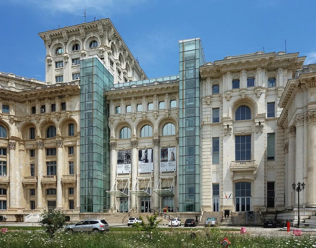

- To be seen todayThe west wing of the Palace of Parliament, which houses the National Museum of Contemporary Art (MNAC).
- On the planThe outline of the house at number 36, under the wall or right beside it.
- MarginThe median error in placing the plan is about 17 metres; here it may be larger.
The outline of the palace is today's, from OpenStreetMap. The 1974 plan was laid over it using 16 landmarks that have not moved: churches, crossings, buildings. The remaining median error is about 17 metres. With that reservation, the house at number 36 falls roughly on the line of the west front.
Uranus Acum places the street in the same part of the building: it “went right through what is today the segment of the palace that houses the MNAC”. The museum gives its address as Calea 13 Septembrie 1–3, wing E4.
The thin sheet left in the air is the 1974 plan, at its own height. The palace is shown as a volume: the outline is the real one, the stepped heights and the façades are schematic.
Sources
- Outline of the Palace of Parliament: © OpenStreetMap contributors
- Cadastral plan of Bucharest, central area, scale 1:2000, about 1974 (DocuBucurești collection, Idei Urbane)
- Uranus Acum, leaflet of the public-space installations, 2019, p. 2 (archived copy)
- National Museum of Contemporary Art (MNAC), address and entrance
- “The hill they moved”: the 1974 heights against today's ground, method and margins
13 Today
Today: the street comes out of the palace through its north side
- To be seen todayThe north front of the palace. The street of 1974 runs into it.
- On the planThe Uranus–Fonteriei fork, with the island of the monument, right in front of the wall.
- MarginAbout 17 metres, as a median error.
The first 180 metres of the walk, from Maior Ene to here, are under the building today. The site Bucureștii vechi și noi says the same: under the People's House lies the stretch between Strada Fonteriei and Strada Maior Ene.
According to the same source, the place of the old monument in the fork would fall today in the car park in front of the entrance of the Chamber of Deputies, on the north side of the palace.
Sources
- Outline of the Palace of Parliament: © OpenStreetMap contributors
- Cadastral plan of Bucharest, central area, scale 1:2000, about 1974 (DocuBucurești collection, Idei Urbane)
- Bucureștii vechi și noi, “Uranus – o stradă pentru eternitate”, 2010 (with Gheorghe Parusi's photograph of June 1980)
- Bucureștii vechi și noi, the main entrance of the Arsenal with the earlier monument at the Uranus–Fonteriei fork
14 Today
Today: the old street hangs in the air, some ten metres above the grass
- To be seen todayThe ground north-west of the palace, sloping towards Izvor.
- On the planThe street of 1974, left at its own height, overhead.
- MarginTwo to three metres in height.
Here, beside the Army Theatre, the street lay at about 82 metres in 1974. Today's ground is at about 72. The difference, roughly ten metres, carries a margin of two to three: the old ground comes from the plan's heights, today's from a satellite model with buildings and trees filtered out.
Up on the palace platform the level is almost that of 1974. The hill was cut here and filled elsewhere; how is shown in “The hill they moved”.
How exact the reconstruction is
The plan is the cadastral plan of central Bucharest at 1:2000, of about 1974, from the DocuBucurești collection. The plan is not reproduced here; the shapes, numbers and heights come from it. Positions are approximate, to about a metre.
The plan shows the street as it was drawn then, not on the eve of demolition. Between 1974 and the 1980s some houses may have changed. The city plan of 1911, at 1:5000, draws the same street with the Alexandria barracks and the Arsenal on the right-hand side; on the copy consulted the houses cannot be told apart, so the 1911 plan serves only as a check.
The plan is laid over today's city using 16 landmarks that stayed in place. The median error, measured by leaving out one landmark at a time, is 17 metres; at a given spot it may be larger. Everything the page says about the palace, “under the building” or “beside the wall”, is to be read with that margin.
The ground heights of 1974 come from the 211 spot heights read from the plan for the page about the hill. Today's ground comes from the Copernicus GLO-30 model with buildings and trees filtered out, with an error of two to three metres. The palace platform is set at 87.6 metres, after the 1:500 cadastral plan updated in 1991.
Black and white is used only for things that appear in photographs of this street: the setts, the tram rails and wire, the kerbs, the poles, the monument, the main building of the Arsenal, the precinct wall and the Army Theatre building. The photographs date from the early twentieth century to the 1980s. Most are described and linked to their source, not reproduced.
Watercolour is everything assumed: the houses on the left, the long range on the right, the sheds, fences, chimneys, colours. The pavement trees are in photographs, but the place of each is chosen, so they too come in at the step of assumptions. Behind the first row of houses the roofs are divided schematically.
The Palace of Parliament is a volume in four steps raised on its real outline. The heights of the steps and the fronts are schematic.
The light is that of an October morning; it is chosen, not reconstructed for a given day. The sky is empty at the step of the plan, grey at the step of the photographs and coloured only from the step of assumptions on, because neither the plan nor black-and-white photographs hold colour.
The page gives no total of houses demolished or people moved out of the quarter. The figures in circulation have different sources and units; they are set side by side on the page about the hill.
More about this hill
- The hill they moved — the whole quarter from above, with the hill cut and filled and the two churches moved on rails.
- Ceaușescu's Bucharest: House, Square, Palace in One Day — an itinerary through today's city.
Sources
The geometry comes from the cadastral plan. Facts about the buildings come from the National Archives' article on the abolished streets, from the Uranus Acum project, from memoirs and from the captions of photographs gathered by the site Bucureștii vechi și noi (Old and New Bucharest).
- Cadastral plan of Bucharest, central area, scale 1:2000, about 1974 (DocuBucurești collection, Idei Urbane)
- Uranus Acum, leaflet of the public-space installations, 2019, p. 2 (archived copy)
- Bucureștii vechi și noi, “Uranus – o stradă pentru eternitate”, 2010 (with Gheorghe Parusi's photograph of June 1980)
- Bucureștii vechi și noi, the corner of Uranus and Maior Ene during the demolitions (photo: Andrei Bîrsan)
- Scena9, “Uranus atunci, Uranus acum” (on the Uranus Acum exhibition at MNAC)
- Zeppelin, “Uranus Now”: exhibition, digital archive and public-space installations, MNAC, 17.10.2019–12.01.2020
- Bucureștii vechi și noi, the tram stop at Maior Ene, early 1940s
- Bucureștii vechi și noi, the Firefighters' Monument, 1970s (photo: Traian Bădulescu sr.)
- Postcard of the Arsenal and the Firefighters' Monument, after 1901 (Wikimedia Commons)
- Bucureștii vechi și noi, the main front of the Arsenal, 1906 (photo: Chusseau-Flaviens)
- Alexandru Popescu, “Casele Bucureștilor (XXXVII)”, Ziarul de Duminică
- Romanian Wikipedia, “Monumentul Eroilor Pompieri din București”
- Uranus Acum, “Locuri ale memoriei” (archived copy)
- Bucureștii vechi și noi, the main entrance of the Arsenal with the earlier monument at the Uranus–Fonteriei fork
- Plan of the city of Bucharest, official edition 1911, scale 1:5000, Army Geographical Service (Wikimedia Commons, public domain)
- Main building and gate of the Arsenal, old photograph (Wikimedia Commons)
- Emanuel Bădescu, “Bucureștiul neogotic (III)”, Ziarul de Duminică, 12 December 2013
- Bucureștii vechi și noi, the Arsenal precinct wall seen from Strada Militari, 1976 (photo: Radu Ștefănescu)
- Mara Popescu, “Uranus neighborhood: erased from the city, remembered by its inhabitants”, TU Delft, 2024, pp. 21–22
- Bucureștii vechi și noi, the buildings at Uranus 6–6A, postcard from the First World War
- Șerbănați, “Copilăria mea”, memoir of 1950–1957
- Narcis Ispas (National Archives of Romania), “Și străzile mor…” (Streets die too), 19 October 2018
- Bucureștii vechi și noi, the crossing of Uranus and Izvor (photo: Mircea Petrus Iliescu)
- Bucureștii vechi și noi, “Lumea dispărută a Cartierului Uranus (II)”, 2013 (a former resident's letter)
- Uranus Acum, interview with Dumitru Belu and Mircea Stroe, 2021 (archived copy)
- Outline of the Palace of Parliament: © OpenStreetMap contributors
- National Museum of Contemporary Art (MNAC), address and entrance
- “The hill they moved”: the 1974 heights against today's ground, method and margins
- Today's ground: Copernicus DEM GLO-30