Chapter 1 · Maps and coordinatesLesson 1.4
Global positioning systems: how a GPS receiver calculates its position
Your phone sends nothing to the satellites. How, then, can it find where you are to within a few metres?
Before you read: what do you think?
Your phone's clock is out by a millionth of a second. How far out is the calculated distance to a satellite?
See the answer
By 300 m. By 300 m. The signal travels at the speed of light, about 300,000 km/s, so a millionth of a second means 0.3 km. That is why satellites carry atomic clocks and the receiver needs a fourth satellite to correct its own clock.
GPS satellites fly about 20,200 km above Earth. A radio signal from one of them reaches your phone in less than a tenth of a second. From four such delays, measured very precisely, the phone calculates its position to within about 5 m under an open sky.
The phone listens: it measures time and calculates distances
Each satellite constantly broadcasts a radio signal containing two things: where it is and the exact time on its atomic clock when the signal was sent. The receiver, whether a phone, watch or navigation device, simply listens. It sends nothing to the satellite.
The receiver compares the time the signal left with the time it arrived. The radio signal travels at the speed of light, about 300,000 km/s, so the distance to the satellite is its speed multiplied by the journey time.
Why at least four satellites are needed
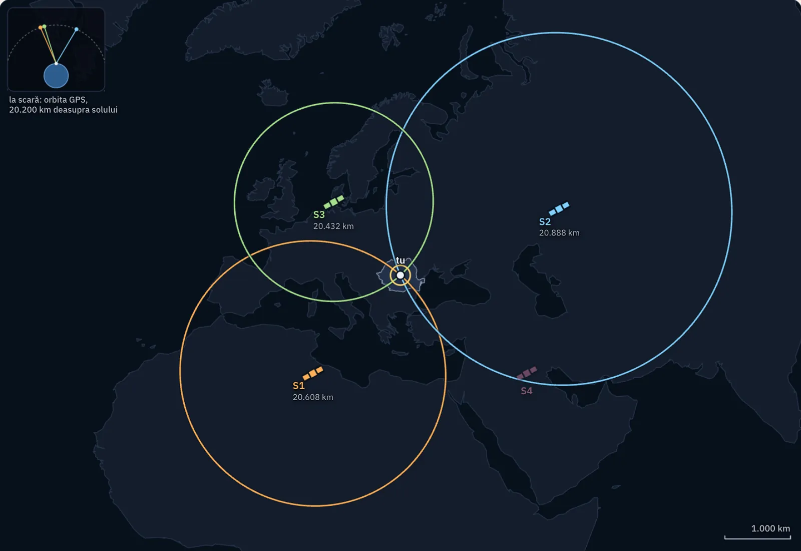
The distance to a single satellite shows only that the receiver is somewhere on a sphere centred on that satellite. A second satellite narrows the possible positions to the circle where the two spheres intersect. A third leaves two points, only one of which is on Earth's surface. This method of finding a point from its distances to other, known points is called trilateration.
Three satellites would be enough if the phone's clock were as accurate as the atomic clocks on the satellites. It is not, and a small error in time means a large error in distance. The fourth satellite solves the problem: with four measurements, the receiver calculates four unknowns: latitude, longitude, altitude and the error in its own clock.
Four systems, one principle
Systems that use satellites to give a position anywhere on Earth are collectively called GNSS, or global navigation satellite systems. There are four: GPS, belonging to the United States, Galileo to the European Union, GLONASS to Russia and BeiDou to China. In everyday speech, “GPS” has come to mean any of them.
The orbits of GPS satellites were chosen so that at least four satellites are visible at once from almost anywhere on the planet. Today's phones receive signals from several systems at the same time.
For the curious
GPS needs at least 24 working satellites; for more than ten years it has had 31. The satellites are arranged in six orbits, and each circles Earth twice a day. Galileo satellites fly higher, at 23,222 km.
| Satellites heard | Signal time | Distance | Possible positions |
|---|---|---|---|
| one | 68.74 ms | 20,608 km | a circle 12,400 km long |
| two | 69.67 ms | 20,888 km | two points, 1,050 km apart |
| three | 68.15 ms | 20,432 km | one point, if the clock is exact |
| three, clock 1 µs fast | every distance longer by 300 m | a wrong point, 52 m away on the map and 331 m underground | |
| four, clock 1 µs fast | 69.37 ms | 20,798 km | the correct point and the clock error |
The receiver is in the middle of Romania. From a satellite directly overhead, the signal would take 67.4 ms. A clock error of 1 ns moves every distance by 30 cm, one of 1 µs by 300 m, one of 1 ms by 300 km.
Calculation. Each circle is where the sphere of a measured distance cuts the surface of the Earth. The calculation is done in space, with the Earth taken as a sphere of radius 6,371 km, the satellites 20,200 km above it and the speed of light 299,792.458 km/s; the map shows it from above. The arrangement of the satellites is chosen for the drawing. The atmosphere, terrain and reflections, which give a real phone an error of a few metres, are left out.
How accurate is the position?
Under an open sky, a phone finds its position to within about 4.9 m. Near tall buildings, under trees or indoors, the error grows: some signals are blocked, while others reach the receiver after bouncing off walls and appear to come from farther away. That is why the dot on the map sometimes moves even when you stand still.
Professional receivers that pick up signals on two frequencies and corrections from fixed ground stations achieve accuracy to within a few centimetres. The number of decimal places shown by an app says nothing about its accuracy.
What it is used for and what it does not do
Satellite positioning guides cars, aircraft and ships, helps rescue teams find people, steers tractors in straight rows in farming and provides coordinates for land surveys. Geographers use it to record the exact location of each observation in the field.
Satellites send only time and positions; they do not send the map. The map on the screen comes from the internet or the phone's memory. So without internet access, the phone can still calculate its coordinates, but the map may no longer load.
Worked example
From time to distance
A receiver finds that a satellite's signal took 0.07 seconds to reach it. Distance is speed multiplied by time: 300,000 km/s × 0.07 s = 21,000 km. The receiver is therefore somewhere on a sphere with a radius of 21,000 km around the satellite.
How much does a clock error matter? If the time is measured incorrectly by a millionth of a second (0.000001 s), the distance is out by 300,000 km/s × 0.000001 s = 0.3 km, or 300 m.
For an error of only 3 m, the time must be known a hundred times more precisely, to within one hundredth of a millionth of a second. That is why satellites carry atomic clocks and the receiver needs a fourth satellite to correct its own clock.
In Romania
87 fixed stations that correct the signal
The National Agency for Cadastre and Land Registration maintains the National Network of Permanent GNSS Stations, with 87 stations across the country, from Botoșani to Zimnicea and from Sânnicolau Mare to Sulina. The system that uses them is called ROMPOS, the Romanian Position Determination System.
Each station has a fixed antenna whose coordinates are known very precisely. The stations receive signals from several satellite systems: the station at Sulina, for example, receives GPS, GLONASS, Galileo and BeiDou. By comparing the position calculated from the signals with its actual position, the station finds how far out the signals are at that time and in that area. Corrections are sent to the receivers of specialists surveying land, roads and buildings. With these corrections, the error falls from a few metres to a few centimetres, accurate enough to mark the boundary between two properties.
In brief
- GNSS means global navigation satellite systems; the four are GPS (United States), Galileo (European Union), GLONASS (Russia) and BeiDou (China).
- GPS satellites fly at about 20,200 km and continuously transmit their position and the exact time; the receiver only receives signals.
- The receiver measures the journey time of each signal and calculates the distance: distance is the speed of light (about 300,000 km/s) multiplied by time.
- At least four satellites are needed for a position: from four distances, the receiver calculates latitude, longitude, altitude and the error in its own clock.
- Under an open sky, a phone has an error of about 5 m; buildings, trees and signal reflections increase it, while fixed correction stations reduce it to a few centimetres.
- The position is calculated from satellite signals without internet access; the map on which it appears is separate.
Common mistakes
WrongGPS works only if the phone has internet access.
RightThe position is calculated from the satellites' radio signals. The internet supplies the map and speeds up the start, but coordinates can be found without it.
WrongThe phone sends a signal to a satellite, and the satellite replies with its location.
RightThe receiver only listens. Satellites broadcast the same signals to everyone and do not know who receives them; the position is calculated in the phone.
WrongThree satellites are enough, one for each coordinate.
RightThree would be enough only if the receiver had a perfect clock. The fourth satellite is needed to find the clock error too.
Test yourself
Six questions. For the first five you see the explanation at once, with the paragraph of the lesson that supports it; for the ones with a written answer you compare with a good answer.
How many satellites does a receiver need at least to calculate its position?
Answer
d) Four. The receiver has four unknowns: latitude, longitude, altitude and its clock error. Four unknowns require four measurements.
The signal travels at about 300,000 km/s. What distance error, in metres, results from a time error of 0.000002 s (two millionths of a second)?
mAnswer
600 m. 300,000 km/s × 0.000002 s = 0.6 km = 600 m.
What does the fourth satellite do in the position calculation?
Answer
b) It allows the receiver's clock error to be corrected. The receiver's clock is not atomic. The fourth measurement allows its error to be calculated alongside the three coordinates.
You are on a mountain under an open sky, with no mobile signal or internet access. What happens to positioning?
Answer
a) The phone calculates its coordinates, but the map may be missing. Satellite signals reach the receiver independently of the mobile network. The map depends on the internet or the phone's memory.
Which satellite navigation system belongs to the European Union?
Answer
c) Galileo. Galileo is the European system. GPS belongs to the United States, GLONASS to Russia and BeiDou to China.
You are waiting for a friend on a narrow street between tall blocks of flats. You stand still, but the blue dot on the map wanders tens of metres. Explain why and say where you would move to make the position stable.
A good answer
The buildings block some satellite signals, while others reach the phone after bouncing off walls. The reflected signal has travelled farther, so the receiver calculates a distance that is too great and a wrong position that changes from moment to moment. Move to an open place, such as a square or a wide junction, where the phone can see more satellites directly.
A complete answer names the blocking and reflection of signals, links reflection to an incorrect calculated distance and suggests a place with an open sky.
Terms
- GNSS
- Global navigation satellite systems; the collective name for GPS, Galileo, GLONASS and BeiDou.
- GPS
- The United States global positioning system, with satellites at an altitude of about 20,200 km.
- Galileo
- The European Union's satellite navigation system, with satellites at an altitude of 23,222 km.
- receiver
- A device (phone, watch or navigation device) that receives satellite signals and calculates a position.
- trilateration
- A method of finding a point's position from its distances to several known points.
Sources and link to the programme
- GPS.gov – Space Segment – at least 24 satellites, 31 in operation for over a decade, altitude of about 20,200 km, six orbital planes, two orbits per day
- GPS.gov – GPS Accuracy – 4.9 m error for phones under an open sky; reduced accuracy near buildings and trees; accuracy to within a few centimetres using two frequencies and correction systems
- NOAA – What is GPS? – at least four satellites visible from almost anywhere on the planet
- NOAA – Geodesy tutorial: The Global Positioning System – distance as signal speed multiplied by time; successive spheres; the fourth satellite to correct the receiver's clock; atomic clocks on satellites
- EUSPA – What is GNSS? – the four global systems: Galileo (EU), GPS (US), GLONASS (Russia), BeiDou (China)
- ESA – What is Galileo? – Galileo orbit altitude, 23,222 km
- ROMPOS (ANCPI) – Istoria RN-SGP, copie arhivată din 11 iunie 2026 – the National Network of Permanent GNSS Stations has 87 stations; stations at Botoșani, Zimnicea and Sânnicolau Mare
- ROMPOS (ANCPI) – pagina principală, copie arhivată din 11 iunie 2026 – the SULI station at Sulina; constellations received: GPS, GLONASS, Galileo, BeiDou
From the programme: “Using global positioning systems” (common core). Programme competences covered: 2.2, 2.4, 5.5.