For more than a thousand years, between the Carpathians, the Balkans and the Black Sea, people built their houses one on top of another, on the same spot, until their villages were mounds several metres high. Archaeologists call them tells. The Varna cemetery, with the oldest gold worked in quantity, belongs to a related culture.
Beyond the Carpathians, in Moldavia, was Cucuteni. In the same centuries, to the south, in Muntenia, Dobruja and northern Bulgaria, was Gumelnița: its villages ring today's Bucharest.
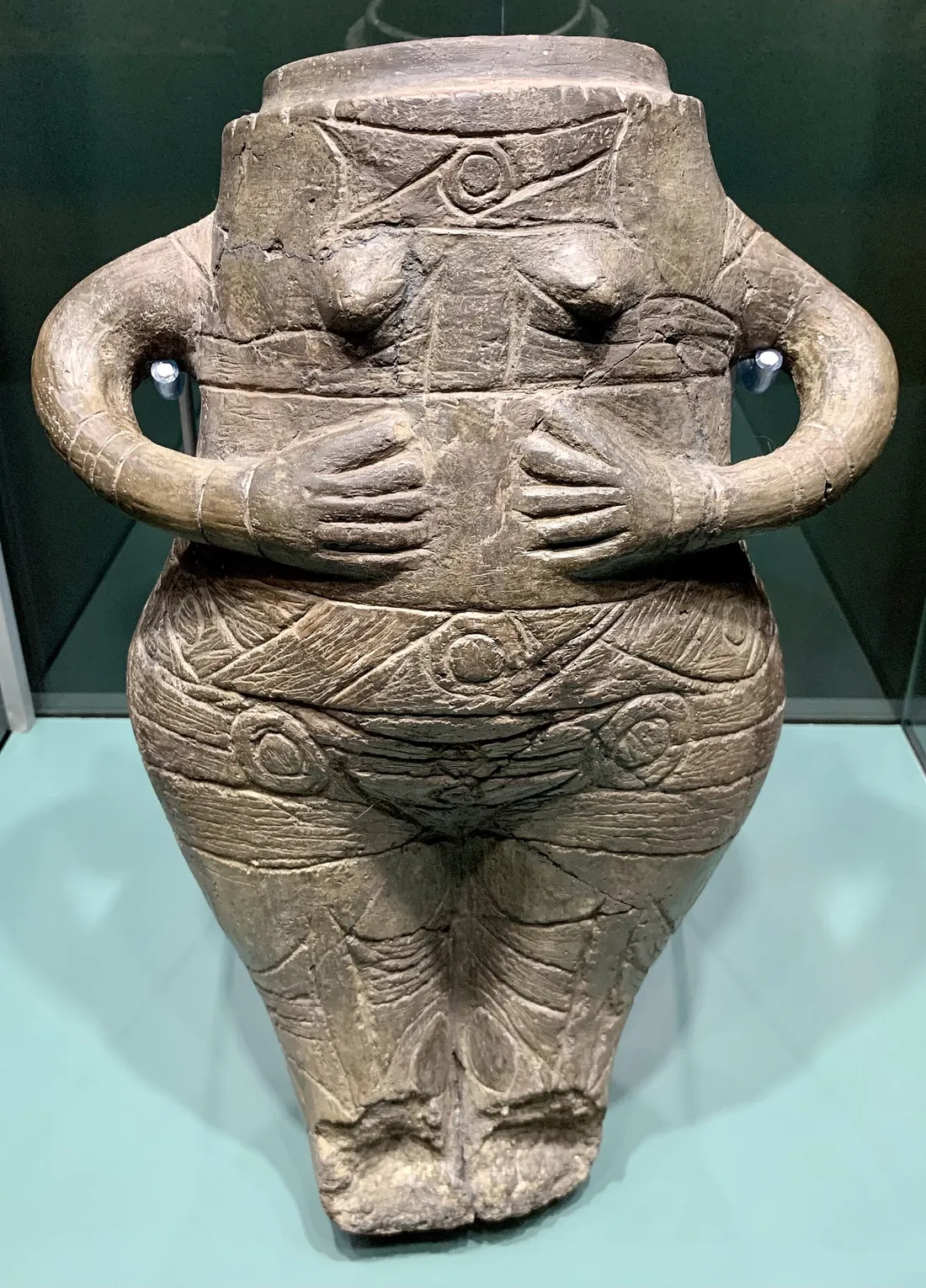
The anthropomorphic vessel from Vidra, 42 cm tall, found in the 1930s at Vidra, some 20 km from central Bucharest. Bucharest City Museum. Photo: Neoclassicism Enthusiast, Wikimedia Commons, CC BY-SA 4.0
Each dot on the map is a settlement or cemetery dated by radiocarbon. It lights up in the centuries when its dates show people there. The curve below sums all 406 published dates: the higher it is, the more dates fall in that century.
Scroll: each step moves the clock a few centuries.
4,900BC
Summed dates
490047004500430041003900
c. 4,900 BC
The first villages
The earliest dates appear in two places at once: north of the Danube, in the Mostiștea valley, and to the south, in what is now north-eastern Bulgaria. Their pots keep the style of the Boian communities who lived here before.
c. 4,700 BC
Houses grow in place
The houses are of timber and clay. When one decays or burns, the next is raised on its remains, on the same spot. Generation after generation, the village climbs. At Hârșova, on the Danube, the layers left by the Gumelnița communities reached about seven metres.
c. 4,600 BC
The gold of Varna
On the Black Sea coast, at Varna, a cemetery of a related culture comes into use. A single grave, number 43, held more than 990 gold objects weighing 1.5 kg in all. The Varna cemetery holds the oldest large assemblage of gold objects known.
c. 4,500 BC
The widest reach
By about 4500 BC, the related communities that archaeologists group together as the Kodjadermen–Gumelnița–Karanovo VI complex stretch from southern Ukraine to northern Greece. To the north-east, in Moldavia, the Cucuteni communities live in the same centuries. In a house on the Gumelnița mound, two pots painted in three colours in the Cucuteni style were found.
c. 4,400 BC
The peak
The curve peaks around 4400 BC. At Pietrele, near Giurgiu, a village stood on a mound that is 9 metres high today, on the edge of a lake that covered much of the floodplain. People caught carp and catfish, grew barley, wheat and lentils, and kept stores in jars of up to 400 litres. More than 250 copper objects were found there, with no sign they were made on the spot, and crucibles used in experiments with lead ore.
c. 4,380 BC
A village of at most 100 people
At Sultana, in the Mostiștea valley, the village on the mound had, by the archaeologists' estimate, 10–20 houses lived in at the same time: at most 50–100 people. By around 4380 BC their defensive wall was gone, collapsed or pulled down, and terraces were filled over it to make room for more houses.
c. 4,350 BC
The decline begins
From here the curve falls and never recovers. The Varna cemetery goes out of use at about the same time. The decline lasts some 550 years.
c. 4,300 BC
Four people raised elsewhere
Among those buried at Gumelnița, strontium isotopes in their teeth show that four of the 17 people studied spent their childhood elsewhere, probably somewhere south of the Danube. Among them are two women buried face to face in the same pit and a little girl, the only one buried on the mound rather than in the cemetery. All four lived after 4350 BC.
c. 4,250 BC
Pietrele is left
The Pietrele mound is no longer lived on after about 4250 BC. Others hold out longer.
c. 4,000 BC
The last at Gumelnița
On the mound near Oltenița that gave the culture its name, the last dates reach towards 4000 BC. The community here was one of those that lasted longest. At Hârșova, the Gumelnița layers are capped by a metre and a half with a different kind of pottery, which archaeologists call Cernavodă I.
c. 3,800 BC
Silence
By about 3800 BC the signal is gone. The mounds remain. Vineyards and cemeteries later grew on them, and in the nineteenth century the one at Oltenița was thought to hide a Roman fortress.
The curve is rebuilt here with the authors' method, from their published data (Popescu et al., 2023). It measures dated activity, which follows population but also how people settled and where archaeologists have dug.
A mound like this is mostly the village itself: walls of burnt clay, relaid floors, hearths, pits, everything left by generations who lived on the same patch of ground. At Gumelnița, the village started on an erosion remnant, a piece broken off the Danube terrace, and added four or five metres to it.
Three mounds drawn to the same scale, with a 1.70 m person beside them. At Hârșova, the layer thicknesses are those published by the French–Romanian team. At Gumelnița and Pietrele, the drawing shows only the overall height.
A finger's width every two years
At Gumelnița the deposits reach 5 metres in the south-eastern corner dug in recent years, and the mound's dates span about 780 years. On average that is roughly 6 millimetres a year: a metre every 150 years, or every five or six generations. In reality the mound grew in jumps, each time a house was pulled down or burnt and another built on top.
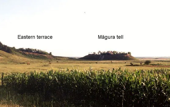
The Pietrele mound, 9 m high, seen across a maize field. Photo: Steven Trick, Wikimedia Commons, CC BY 3.0
The giants' potsherds
In the early 1870s, Alexandru Odobescu asked village teachers to write to him about the old remains in their area. A teacher from Oltenița replied that on the edge of town there was a mound where the plough turned up many potsherds, “probably prehistoric”.
Half a century later, the villagers of rural Oltenița had another answer: the mound was full of sherds “from the giants”. One man left his strip on the mound unworked because of the “bricks” 30–40 cm down. They were the burnt walls of houses more than 6,000 years old.
Vladimir Dumitrescu dug there in the summer of 1925, helped by Ion Nestor. The mound, covered in vines, bore the name of its owner, Calomfirescu, who would not let them dig even on the paths. The national archaeological register counts it as the first Romanian stratigraphic excavation of a prehistoric settlement. From its layers Dumitrescu separated phases A and B, and the mound's name became the name of the whole culture.
Between 1938 and 1940 the director of the Bucharest City Museum, Dinu V. Rosetti, dug there too. The register records that the gold objects found then were lost in the Second World War, when the museum's collections were evacuated to Craiova.
A few things from their world, and where they are kept today.
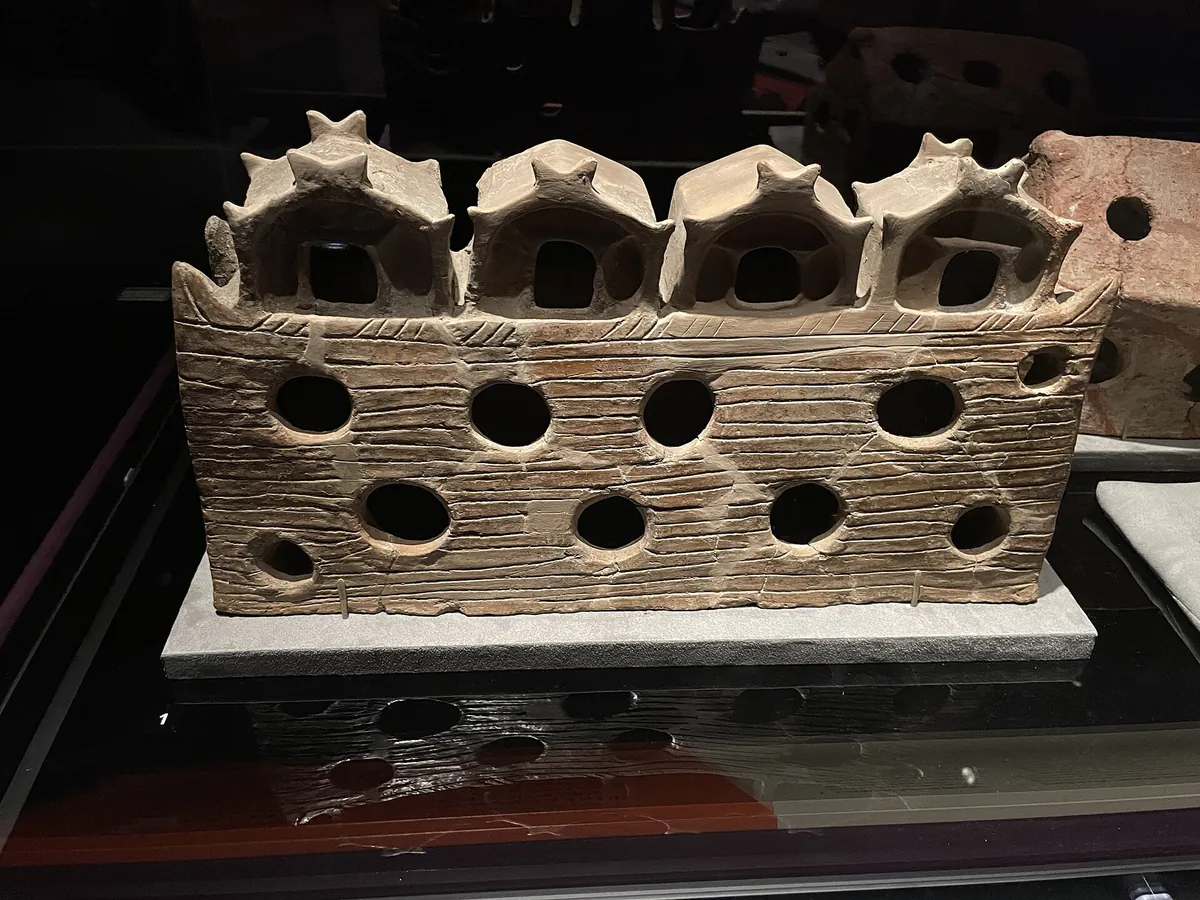
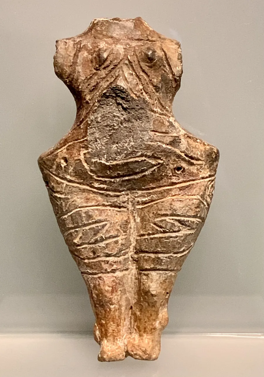
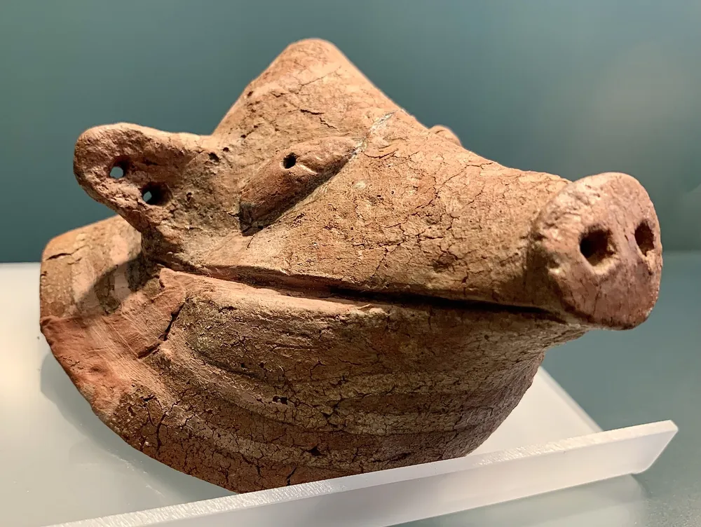
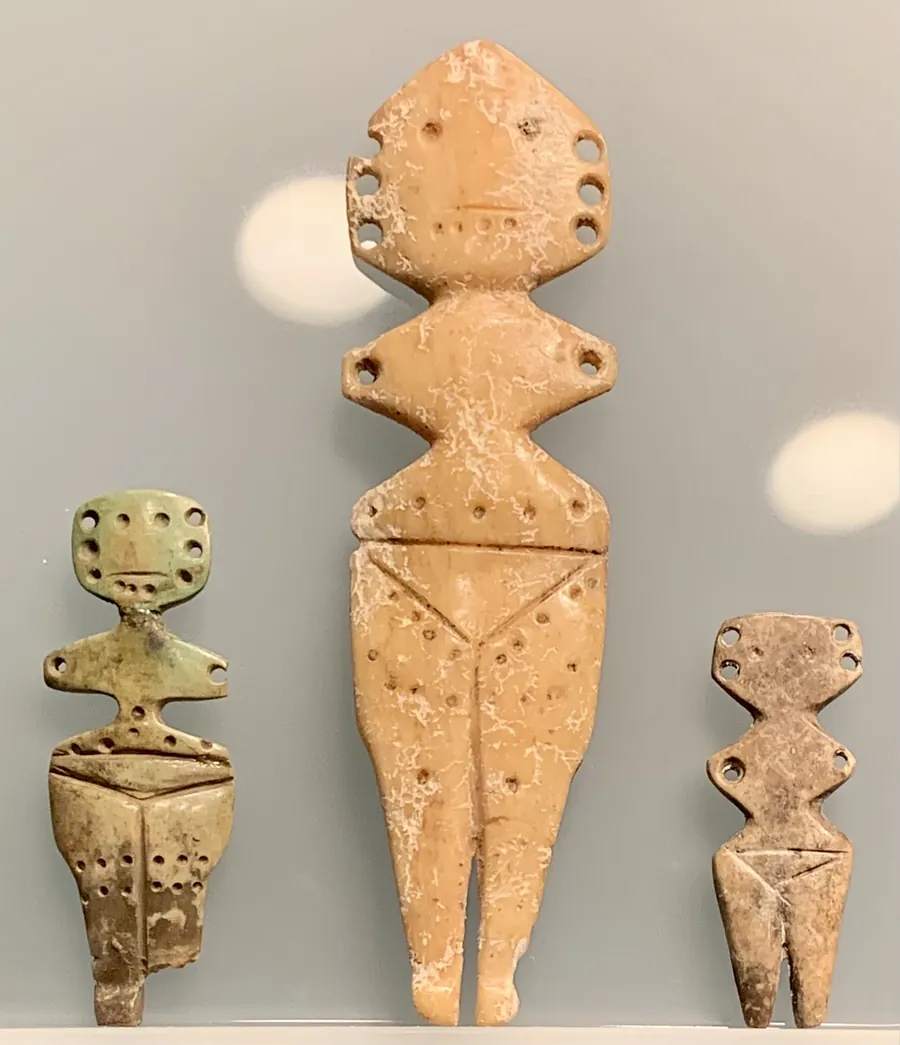
The Căscioarele model A clay model 51 cm long: four roofs on a pierced base. Found in 1963 on Ostrovel island, near Căscioarele. National History Museum of Romania. Photo: CryolophosaurusEllioti, Wikimedia Commons, CC BY 4.0A figurine from a house Clay figurines like this one turn up in Gumelnița houses. We do not know what they meant to those who made them. This one is from Vidra. Bucharest City Museum. Photo: Neoclassicism Enthusiast, Wikimedia Commons, CC BY-SA 4.0A lid with a snout A pot lid modelled as a pig's head. Gumelnița Civilisation Museum, Oltenița. Photo: Neoclassicism Enthusiast, Wikimedia Commons, CC BY-SA 4.0Bone figurines Flat silhouettes cut from bone, from Vidra, Sultana and Sărulești. The largest prismatic bone figurine from Sultana is 13.6 cm. Photo: Neoclassicism Enthusiast, Wikimedia Commons, CC BY-SA 4.0Grave 43 at Varna More than 990 gold objects in a single grave. Varna Archaeological Museum. Photo: Gabriele Burchielli, Wikimedia Commons, CC BY 2.0
In 1960 the Gumelnița mound also yielded a gold idol weighing a single gram and a centimetre and a half long, kept at the Oltenița museum.
No one knows for sure. The decline stretched over centuries and looked different from place to place: Pietrele was left around 4250 BC, the Gumelnița mound was lived on until close to 4000. Here is what each side argues.
Climate
Bernhard Weninger and Thomas Harper, among others
Rapid climate change made floodplain farming harder; people shifted towards herding, with smaller, more mobile settlements.
Their time windows are wide, and the data come from different regions.
Less food
Johannes Müller, Cătălin Lazăr et al., at Sultana
Towards the end of the village at Sultana, hunting and foraging matter more, a usual sign of a food crisis. The first isotope analyses point to warming and drying.
Preliminary results, from a single site.
Not so fast
John Chapman
The Gumelnița mounds were left after the supposed climate event, and some were lived on into the early fourth millennium. A change of climate alone does not explain why villages met different fates.
Newcomers from the steppe
David Anthony
More than six hundred mounds were burnt and abandoned between 4200 and 3900 BC, and steppe groups appear at the same time. Anthony leaves open whether they caused the crisis or came after it.
A broad synthesis; not every mound was burnt.
Mixed people
Igor Bruyako, Blagoje Govedarica, Igor Manzura; Penske et al.
At Orlovka-Kartal, on the Lower Danube, Cernavodă I graves have parallels both on the Danube and in the steppe, and the DNA shows people of different ancestry buried side by side.
Heat and water
Henrieta Todorova
Warming and unstable water: droughts, dried-up springs, floods, erosion. A steppe invasion alone does not explain the break.
Boom and bust
Gabriel Popescu, Cătălin Lazăr et al.
A rapid rise followed by an equally rapid fall resembles other Neolithic booms in Europe, though part of the pattern may reflect how people settled rather than how many there were. The causes “require more in-depth research”.
Ancient DNA shows these communities descended mostly from the first farmers who came from Anatolia, with some Balkan hunter-gatherer ancestry. Steppe ancestry appears only sporadically, at Varna and Smyadovo.
Around Bucharest, this age means Gumelnița, not Cucuteni. But inside the city, archaeologists have mostly found traces of their forerunners, the Boian communities.
In Bucharest, Gumelnița shows up only in a few potsherds, some of uncertain attribution, and four flint tools. Its mounds lie just beyond the edge, all in Ilfov county, 11–19 km from Piața Unirii. A Bucharest City Museum study called them “ghost monuments”: of five, only the one at Glina can still be clearly seen.
Gumelnița in the city
Gumelnița mounds around it
Boian or Gumelnița
Boian, the forerunners
1
Lacul Morii, 1985
While the lake's dike was being built, archaeologist Vasilica Sandu picked up, from a field by the Pasteur Institute, a few sherds “with a profile specific to the Gumelnița culture”. Half the spot is now under the dike.
2
Bucureștii Noi, 2013
In an Eneolithic pit by the Străulești cemetery, a Bucharest City Museum rescue dig found four flint tools characteristic of the Gumelnița culture.
3
Băneasa, on the lake shore
On Bujorului Street in 2006, eight sherds turned up, “very probably of Boian or Gumelnița type”. The national register lists a settlement here with that uncertain attribution.
4
Cățelu, Lake Pantelimon
Three Boian pit houses, sunk into the ground, dug by Valeriu Leahu in the early 1960s.
5
Giulești–Sârbi
By the Chiajna monastery: Boian and Dudești villages, older than Gumelnița.
6
Militari–Câmpul Boja
On the Dâmbovița terrace, among traces of other ages, a Boian settlement.
7
Măgurele, Movila Filipescu, 11 km
The village on the mound dates from the start of the Gumelnița culture. The mound has been flattened: today it is a vegetable plot, and Eneolithic sherds come up with every ploughing. A playground has been built next to it.
8
Măgura Jilavei, 12 km
Here, in 1930–1931, Dinu V. Rosetti found the first Gumelnița defensive ditch. The mound was eaten away by a brickworks quarry. In 2015 the archaeologist Vasile Opriș wondered how many Bucharest buildings have bricks made from its clay in their walls.
9
Glina, La Nuci, 14 km
The mound you can still see: 4 m, Boian at the bottom, Gumelnița above, the Bronze Age on top. The builders of the motorway to the sea took soil from its northern extension. In July 2026 the Bucharest City Museum and its partners found an unburnt Gumelnița house here, with an intact figurine, and storage pits more than 2.5 m deep.
10
Chitila–Fermă, 15 km
A Gumelnița mound, bulldozed flat in the 1970s when the banks of the Colentina were reworked. A remnant a few metres long and a few dozen wide survives, overgrown with thorns.
11
Vidra, Măgura Jidovilor, 19 km
More than 6 m of layers: Boian at the bottom, then three Gumelnița levels. The Vidra vessel came from the last. Rosetti dug almost all of it in 1931–1933 and what was left was levelled; the spot can now be found only by its coordinates and a large, half-dead walnut tree.
Glina is the nearest of the mounds you can still see. For a whole one, with its museum beside it, the road leads to Oltenița.
The mound is 4 km north-east of Oltenița. The Gumelnița Civilisation Museum is at 101 Argeșului Street. ↗
Bucharest City Museum
It holds the Vidra vessel and the figurines and tools from around the city. In 2015 the vessel was on show in the archaeology room of the Suțu Palace. ↗
The dates: 406 radiocarbon dates from 59 sites, the file published by Popescu et al. (Radiocarbon, 2023; Zenodo 10.5281/zenodo.5701137). The article mentions 440 dates; the 406 in the file are used here. IntCal20 calibration, site bins of 100 radiocarbon years as in the authors' code; the curve is smoothed over 50 years. Its peak falls at 4394 BC, against about 4400–4408 in the article.
Map dots light up from the summed probability of each site's own dates, relative to that site's maximum. Dates on human bone can look a century or more too old because of fish in the diet; so the years quoted in the text come from each site's own papers, not from the curve.
Map: Natural Earth (public domain); Bucharest rivers and lakes: OpenStreetMap (ODbL); the municipal boundary: geoBoundaries. The Bucharest points are approximate.
Popescu, G. M. et al. (2023). Sine qua non: inferring KGK-VI population dynamics from aggregated probability distributions of radiocarbon dates. Radiocarbon 65(2). doi.org/10.1017/RDC.2023.6
Tafani, A. et al. (2025). Tracing chalcolithic population mobility using strontium isotopes and proteomics at Gumelnița site, Romania. Scientific Reports. www.nature.com/articles/s41598-025-05671-0
Higham, T. et al. (2018). AMS dating of the Late Copper Age Varna cemetery, Bulgaria. Radiocarbon 60. doi.org/10.1017/RDC.2018.9
Sandu, V. (2014). Descoperiri arheologice pe șantierul de amenajare a Lacului Dâmbovița. București. Materiale de Istorie și Muzeografie XXVIII. bmim.muzeulbucurestiului.ro/fisiere/28-Bucuresti