The whole street, in words
The 15 stops of the walk, from south to north. Each says how it is known.
Four ways of knowing
- Drawn on the planthe surveyor’s line, raised as paper; no height
- From a dated imagea photograph or watercolour with author and year, or the building that still stands; it has walls and shadow
- Assumedheights, roofs, people, trees; pen line
- Todaybuildings from OpenStreetMap, plain volumes
What did Calea Victoriei look like between Zlătari and Lipscani?
1 Assumed
Zlătari church: where the street begins
You are on Podul Mogoșoaiei, at its end towards the Dâmbovița river, in 1846. On the right is the enclosure of Zlătari Inn with its church in the middle; on the left, the enclosure of the monastery of Sfântul Ioan cel Mare. The street runs north past the Russian consulate and Sărindar monastery to the place where the Great Theatre opened in 1852.
Underfoot is sheet 39 of the plan of Bucharest surveyed in 1846 under Major Borroczyn, enlarged to the size of the city: one metre of paper for each metre of street. Every wall stands where the sheet puts it. The heights, roofs and windows of the houses here are drawn in ink, because no dated image shows them.
Pull the handle below to the left and the ink goes: first only the buildings known from photographs and watercolours remain, then only the surveyor's lines, raised as paper.
The church drawn here is not the one that stands today, which was built between 1850 and 1860. Fitted to six churches that still stand where they stood, the plan falls on average 4 metres from today's map; the symbol at Zlătari falls 12 metres from the new church.
Sources
- Plan of Bucharest surveyed and levelled under Major Baron Rudolf Artur Borroczyn, 1846, sheet 39 (copy checked in 1915; scan published by the Ion Mincu University of Architecture and Urbanism)
- The same plan, the sheet of notes: base line, scale, sheet size, magnetic declination, signs
- Florian Georgescu, study of the plan surveyed by Major Borroczyn in 1844–1846, București. Materiale de istorie și muzeografie I (1964)
- The churches of Bucharest: standing, moved and pulled down
- The inns of Bucharest: where they stood and what stands there now
2 Assumed
Constantin-Vodă Inn, a year before the fire
The long outline on the left, along the lane, carries on the sheet the name “Hanul Constantin-Vodă”. A han was a walled inn where merchants lodged and stored goods; this one was built after 1692. The plan catches it whole, in 1846. In March 1847 the great fire of Bucharest left it a ruin, and by 1870 it was gone.
No dated image used here says how high it stood or what its roof looked like. That is why its two floors and its roof are drawn in ink: they are an assumption, after the large inns of the time.
The Post Palace, which houses the National History Museum of Romania, stands on its site today.
3 Drawn on the plan
Why a street was called a “bridge”
Along the street the sheet reads “Podul Mogoșoaei”. Pod, the Romanian word for bridge, was the name of the city's main roads, which were decked with thick oak beams laid across. In 1825 a Russian traveller noted that Podul Mogoșoaiei was “now paved with stone”, and by 1833 the cobbles reached the Grădișteanu houses. At the date of the plan the street was therefore stone, but it kept the name.
The plan's legend says that roads paved with stone are coloured violet and unpaved ones left white. The copy used here is black and white, so this is the one thing that can no longer be read from it.
Measured on the sheet, the street is about 8 metres wide here, wall to wall.
Sources
- Plan of Bucharest surveyed and levelled under Major Baron Rudolf Artur Borroczyn, 1846, sheet 39 (copy checked in 1915; scan published by the Ion Mincu University of Architecture and Urbanism)
- The same plan, the sheet of notes: base line, scale, sheet size, magnetic declination, signs
- Constantin C. Giurescu, Istoria Bucureștilor din cele mai vechi timpuri pînă în zilele noastre (1966), a history of Bucharest
- The plank roads of Bucharest
4 Assumed
Filipescu Inn, at the corner with Lipscani
The large rectangle with a court in the middle is labelled “Hanu Filipescu” on the sheet. The inn is recorded before 1696 and was gone in the second half of the 19th century. The plan gives its exact shape: three wings round a court, the long side on the street. Lipscani, which starts here, was the merchants' street of the old town.
As with Constantin-Vodă, the height is assumed. On the second step of the handle the inn stays an outline, because no dated photograph shows it.
5 Drawn on the plan
Serafim's Inn and the stain on the sheet
Here the street widens into an open place, and on the right the sheet shows an inn with an inner court, labelled “Hanu Serafim”. The sources used here say no more about it than the plan does.
The dark stain on the roadway is not mud from 1846. It is a stain on the paper, caught by the scan. It stays on the ground because the ground is the sheet itself, with everything on it: stains, spot heights, owners' names written by hand.
What stood where the Military Circle is?
6 Assumed
The Russian consulate
On the left, set back from the street in a large yard, is the building the sheet calls “Consulatul Rusesc”. In 1846 Wallachia, the southern Romanian principality whose capital was Bucharest, was under Russian protection, and the consul was among the most powerful men in the city. Major Borroczyn himself had been a Russian officer before he entered the service of the Wallachian state.
The stepped outline of the building is the plan's. The upper floor and the roof are assumed.
Sources
- Plan of Bucharest surveyed and levelled under Major Baron Rudolf Artur Borroczyn, 1846, sheet 39 (copy checked in 1915; scan published by the Ion Mincu University of Architecture and Urbanism)
- Mihai Ștefan Florea, “The Borroczyn plan. A short history”, Muzeul Național (National History Museum of Romania), pp. 59–74
7 From a dated image or the standing building
Doamnei church, hidden in a yard
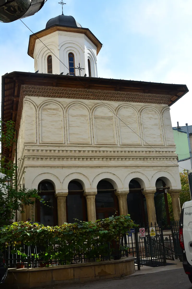

Between the houses on the right stands Doamnei church, built in 1683. It is one of the six churches used to fit the plan to today's map: its symbol on the sheet falls 3 metres from the building that still stands.
Because the church exists, its walls are not an assumption. That is why it is raised in the material of the images, in the tones of an old photograph, and casts a shadow.
8 From a dated image or the standing building
Sărindar monastery
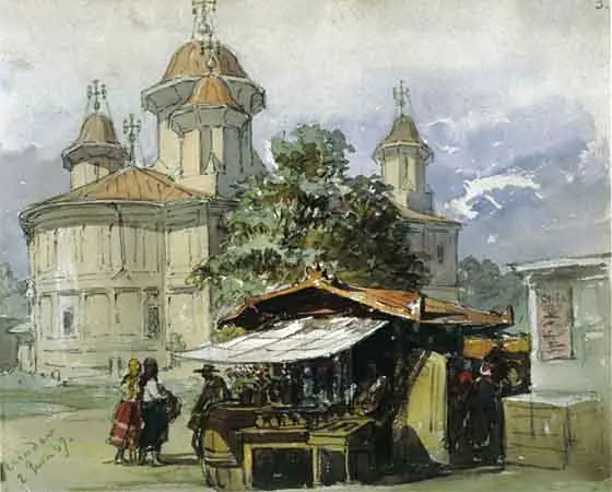

The enclosure on the left is Sărindar monastery, recorded in 1615. On the plan the church is the black shape in the middle of the yard, and towards the street runs a long range of low buildings with the gate at the corner.
The domes come from a watercolour by Amedeo Preziosi dated 1869: a large one over the nave and two small ones at the west end. The watercolour is 23 years later than the plan, so the shape here is that of 1869 set on the outline of 1846.
The church was pulled down in 1893; the historian Constantin C. Giurescu gives 1898. The National Military Circle, an officers' club, was built on the monastery's site between 1911 and 1923.
Sources
- Plan of Bucharest surveyed and levelled under Major Baron Rudolf Artur Borroczyn, 1846, sheet 39 (copy checked in 1915; scan published by the Ion Mincu University of Architecture and Urbanism)
- The churches of Bucharest: standing, moved and pulled down
- Constantin C. Giurescu, Istoria Bucureștilor din cele mai vechi timpuri pînă în zilele noastre (1966), a history of Bucharest
9 Assumed
Ion Slătineanu's houses and the word “Teatru”
The large house on the right carries the name “Ion Slătineanu”. Behind it, to the east, the sheet has a single word beside a long building: “Teatru”. The plan thus marks a theatre in the city before the Great Theatre was begun; which hall it was, the sheet does not say.
The boyars' houses on this side of the street are large (boyars were the landed nobility): Slătineanu's covers almost 1,000 square metres on the plan.
10 Assumed
The property of Beizadea Ghica
The cross-shaped house on the right is entered on the sheet as “Proprietatea Beizadelei Ghica”. Beizadea was the title of a ruling prince's son. Its outline covers almost 770 square metres and stands back from the street in the middle of its plot, as boyars' houses did: a yard in front, a garden behind.
Across the street, the small houses strung along the edge of the bank stand on land of Sărindar monastery. The difference between the two sides of the street can be read straight off the plan, with no image at all.
Where did the old National Theatre stand?
11 Drawn on the plan
Friderih Bosel: lines the plan does not explain
On the right the sheet writes “Friderih Bosel” inside a rectangle set within a larger one. Which of them is the wall of the house and which the edge of the yard cannot be decided from the drawing alone, because the plan draws wall, fence and boundary with the same line.
So the place is left as it is on the sheet: lines raised as paper, with no building in ink. Of the 110 outlines read as buildings on this stretch, 93 were closed on the sheet, 8 were closed across a break in the line of at most 2.3 metres, two were followed by hand, six are church symbols, and the block of the theatre comes from the 1852 edition.
12 Drawn on the plan
The hachures: the bank below the street
The band of short dense strokes that follows the street on the left is the surveyor's sign for a slope. Podul Mogoșoaiei ran along the edge of the terrace, and to the west the ground fell towards the Dâmbovița meadows and the Cișmigiu garden.
The plan was also levelled: the small figures beside the corners are heights, reckoned from a point at the gate of the Metropolitan church. The relief is not raised here: the sheet is laid flat and the slope stays a drawing.
13 From a dated image or the standing building
“The place for the National Theatre”
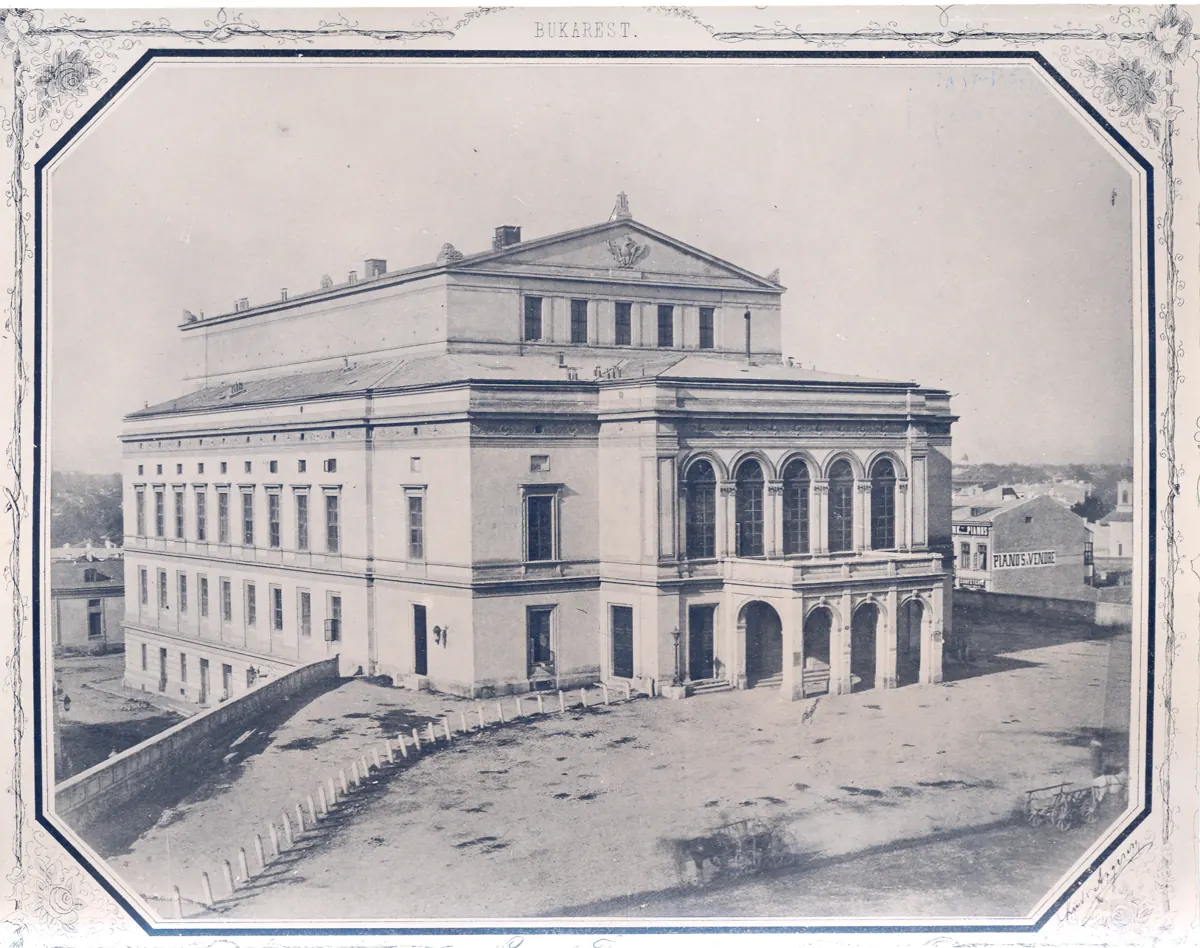

In 1846 the sheet has only an inscription on an empty plot to the left: “Locul pentru Teatru Național”, the place for the National Theatre. The plot had belonged to Filaret's Inn, damaged by the earthquake of 1838. Work began in May 1848, stopped at the revolution, and the theatre opened on 31 December 1852 with a hall of 1,000 seats.
On the lithographed edition of 1852 the same place holds a black block named “Teatru Național”. The outline of the building here comes from it. The height, the three floors and the arcaded portico come from the photograph taken by Ludwig Angerer in 1856.
Set on today's map, the block of 1852 falls 7 metres from the hotel built on the same ground. The theatre was hit by a bomb in August 1944 and then pulled down.
Sources
- Plan of Bucharest surveyed and levelled under Major Baron Rudolf Artur Borroczyn, 1846, sheet 39 (copy checked in 1915; scan published by the Ion Mincu University of Architecture and Urbanism)
- Plan of Bucharest, the lithographed edition of 1852, north-west sheet (scan published by the Ion Mincu University of Architecture and Urbanism)
- Romanian Wikipedia, “Teatrul Național «Ion Luca Caragiale» din București”, history section (read 17 November 2026)
- The inns of Bucharest: where they stood and what stands there now
14 From a dated image or the standing building
The row of houses facing the theatre
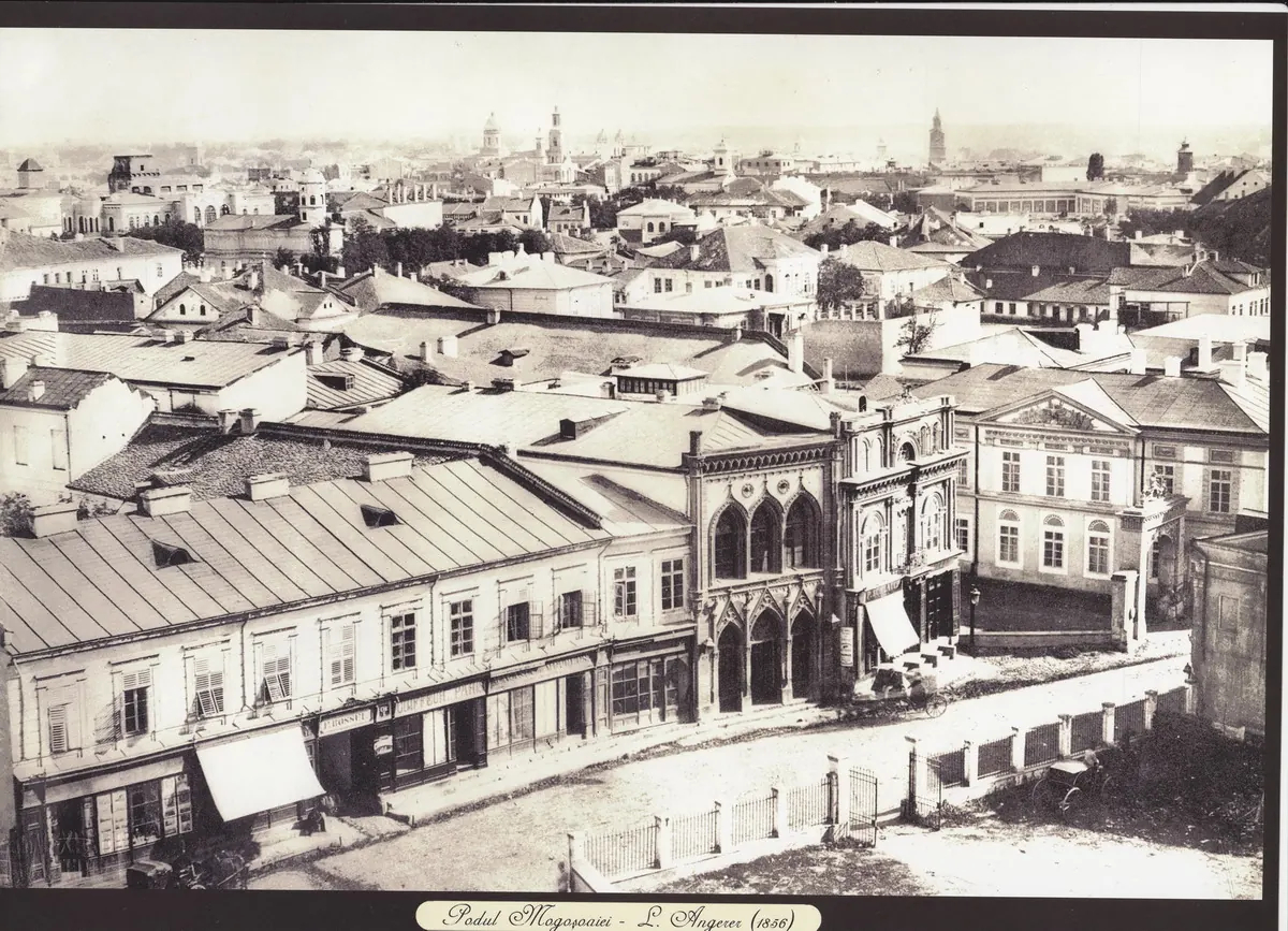

In 1856 Angerer climbed to the roof of the theatre and photographed the street from above. The foreground shows the row across the street: houses of two floors with shops below and hipped roofs covered in sheet metal.
The height and the rhythm of the windows of the four outlines on the right come from there. Which house in the photograph stands on which outline of the plan is a match by position, not a certainty, and ten years lie between plan and photograph.
Sources
- Plan of Bucharest surveyed and levelled under Major Baron Rudolf Artur Borroczyn, 1846, sheet 39 (copy checked in 1915; scan published by the Ion Mincu University of Architecture and Urbanism)
- Plan of Bucharest, the lithographed edition of 1852, north-west sheet (scan published by the Ion Mincu University of Architecture and Urbanism)
15 Today
The same street today

The sheet of 1846 stays on the ground. Over it rise today's buildings, taken from OpenStreetMap, as plain volumes without fronts: 93 buildings on the same strip. The street has been called Calea Victoriei since 1878.
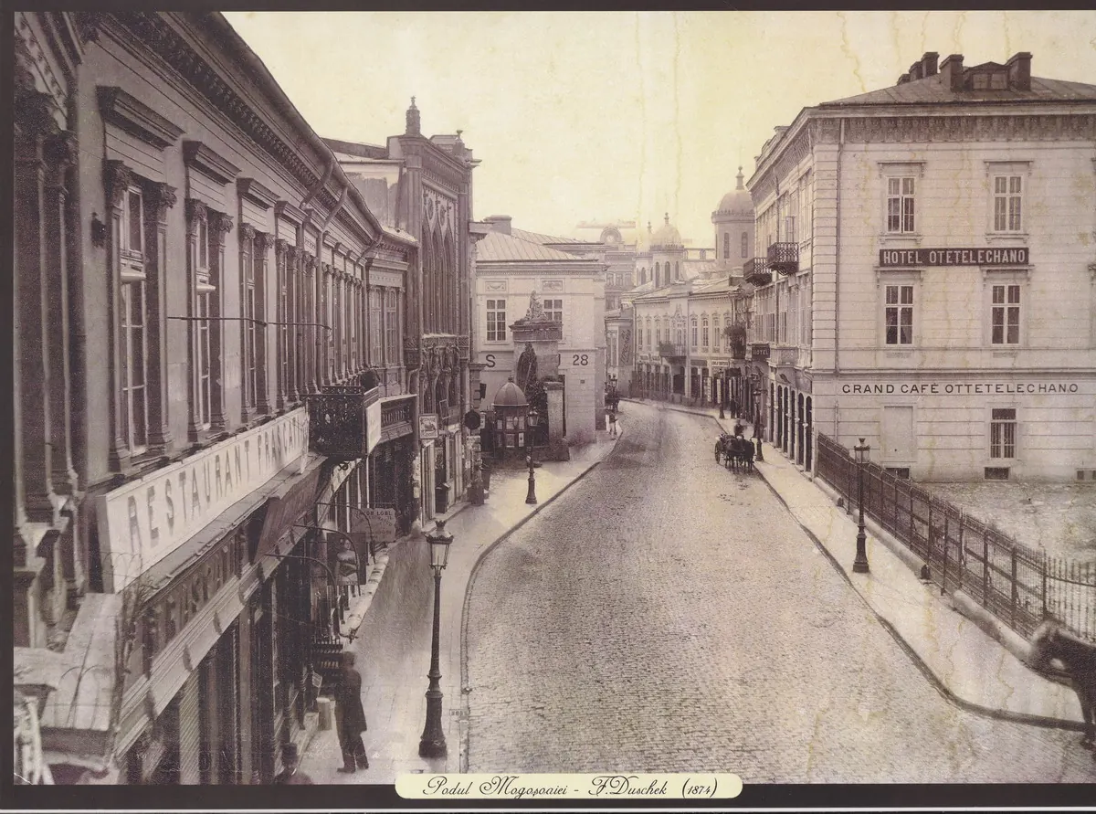
A hotel stands on the site of the theatre, with the old building's portico rebuilt at its entrance. Beside it, on the site of the Oteteleșanu houses, is the Telephone Palace. Further on, the Military Circle covers the yard of Sărindar monastery, and the palace of the CEC savings bank stands over the monastery of Sfântul Ioan cel Mare at the southern end of the sheet.
Of everything drawn on this stretch, Doamnei church still stands, and so does Zlătari church, on a new outline.
Sources
- Plan of Bucharest surveyed and levelled under Major Baron Rudolf Artur Borroczyn, 1846, sheet 39 (copy checked in 1915; scan published by the Ion Mincu University of Architecture and Urbanism)
- Today's buildings and streets: © OpenStreetMap contributors, extract of 30 October 2026
- Romanian Wikipedia, “Teatrul Național «Ion Luca Caragiale» din București”, history section (read 17 November 2026)
- Romanian Wikipedia, “Calea Victoriei” (read 17 November 2026)
- The churches of Bucharest: standing, moved and pulled down
How exact the street is
The geometry comes from sheet 39 of the plan of Bucharest surveyed in 1846 “under the special direction of Major Baron Rudolf Artur Borozin”, as its title page says. The sheet was surveyed on the ground by Eduard Popovici at a scale of 1 to 1,000. The image used is the scan of a black-and-white copy, checked and signed in 1915; the original was coloured.
The sheet was fitted to today’s map through six churches that still stand where they stood: Crețulescu, Doamnei, Dintr-o zi, Colțea, Stavropoleos and Sfântul Ilie at Colțea Inn. The mean error is 3.8 metres (4.1 metres root-mean-square), the largest 6.7 metres. The sheet comes out turned 10.7 degrees from north; the plan’s notes say the sheets are set to the magnetic meridian of 1844, with a declination of 10°15′58″.
Of the 110 outlines read as buildings, 93 were closed on the sheet (breaks of under a metre were ignored), 8 were closed across a break in the line of at most 2.3 metres, two were followed by hand and six are church symbols. The theatre comes from the 1852 edition, which is at a much smaller scale: its position is good to a few metres, not to the wall. The plan draws wall, fence and boundary with the same line, so calling an outline a house remains a reading.
Heights and fronts on the second step come from three images: Ludwig Angerer’s photograph of the theatre of 1856, his view from the theatre roof of the same year, and Amedeo Preziosi’s watercolour of Sărindar church of 1869. All are later than the plan. Doamnei church is raised after the building that exists.
Everything drawn in ink is assumed: the height of the houses, the shape of the roofs, the tower of the old church at Zlătari, the people, the cart and the trees. Small houses have one floor, the inns and the consulate two. None of this comes from a document.
The ground is flat. The slope to the west, which the plan shows by hachures, is not raised. The light is that of a summer morning with the sun low in the east; it was chosen, not computed for a given day.
Today’s buildings come from OpenStreetMap, with heights reckoned from the number of floors where it is recorded. They have no fronts.
Sources
The plan of 1846 and the edition of 1852 are in the public domain. The scans used are those published by the Department of History & Theory of Architecture and Heritage Conservation of the Ion Mincu University of Architecture and Urbanism, Bucharest; sheet 50 is missing from that archive. The photographs and the watercolour come from Wikimedia Commons, with the licence of each file read when it was fetched.
- Plan of Bucharest surveyed and levelled under Major Baron Rudolf Artur Borroczyn, 1846, sheet 39 (copy checked in 1915; scan published by the Ion Mincu University of Architecture and Urbanism)
- The same plan, the sheet of notes: base line, scale, sheet size, magnetic declination, signs
- Florian Georgescu, study of the plan surveyed by Major Borroczyn in 1844–1846, București. Materiale de istorie și muzeografie I (1964)
- The churches of Bucharest: standing, moved and pulled down
- The inns of Bucharest: where they stood and what stands there now
- The Great Fire of 1847
- Constantin C. Giurescu, Istoria Bucureștilor din cele mai vechi timpuri pînă în zilele noastre (1966), a history of Bucharest
- The plank roads of Bucharest
- Mihai Ștefan Florea, “The Borroczyn plan. A short history”, Muzeul Național (National History Museum of Romania), pp. 59–74
- Plan of Bucharest, the lithographed edition of 1852, north-west sheet (scan published by the Ion Mincu University of Architecture and Urbanism)
- Romanian Wikipedia, “Teatrul Național «Ion Luca Caragiale» din București”, history section (read 17 November 2026)
- Today's buildings and streets: © OpenStreetMap contributors, extract of 30 October 2026
- Romanian Wikipedia, “Calea Victoriei” (read 17 November 2026)