The Carpathian arc
RO
Romania · Evidence from 70 million years

The Carpathians: vanished seas, ice and mountain citadels

In Romania, Turda’s salt, the human from Oase and Dacian fortresses preserve histories of very different ages. Follow the evidence on real relief and draw a section across the mountains.

18documented places. A section through the relief shows which evidence lies close together.

Today’s relief. Evidence from different periods.

Age of the evidence, present location

The evidence map

Choose a period, then a point. Colours separate the ages of the evidence; the relief and rivers remain those of today.

ApuseniEastern CarpathiansSouthern CarpathiansTransylvaniaBucharestTimișoaraIașiABHațeg BasinTurda salt mineSlănic PrahovaPeștera cu OasePietrele Valley, RetezatFăgăraș MountainsRodna MountainsSarmizegetusa RegiaCostești-CetățuieCostești-BlidaruLuncani-Piatra RoșieBănițaCăpâlnaRoșia MontanăCiomadul and Lake Sfânta AnaBerca mud volcanoesDomogled–Valea CerneiVrancea seismic zoneToday’s relief. Evidence from different periods.
The evidence hereToday’s relief. Evidence from different periods.
The dinosaur islandSea and saltPeople and glaciersFortresses and minesThe mountains today

Ma = million years; ka = thousand years.

Real relief · calculated distances

Cut across the relief in any direction

Choose two towns or two points on the map. The profile follows the straight line between them; the list shows featured places within 30 km of that line.

184 kmSection length
2,168 mHighest sampled elevation
3Places within 30 km
0100020000 km184 kmm
Bihor — Făgăraș0 kmSampled elevation

Approximate elevations from ETOPO 2022, sampled at roughly 1 km. Narrow peaks are smoothed. The profile shows today’s surface, without inferred geological strata.

Evidence near the section

Hațeg was not an island in a sea from 14 million years ago

Dinosaurs lived here before the salt and fortresses. Tens of millions of years separate these worlds.

Fossils from Hațeg, a basin in southwestern Transylvania, belong to the Late Cretaceous, when Europe contained many islands. Csiki-Sava and colleagues’ 2015 synthesis places the regional fauna in that archipelago. Some dinosaur lineages evolved small bodies; several kinds of evidence support insularity, rather than the shape of today’s basin.

Today’s Carpathians cannot supply the outline of that ancient island. A fossil found at low elevation does not tell us how high the animal lived, and a present summit was not automatically dry land in the Cretaceous. The map point answers a different question: where is the evidence now?

Csiki-Sava et al. (2015), Island life in the Cretaceous

Hațeg’s dinosaurs compared at true scale ↗
Why is there salt beside the mountains?

At Turda and Slănic, a soluble rock preserves the history of salt-water basins.

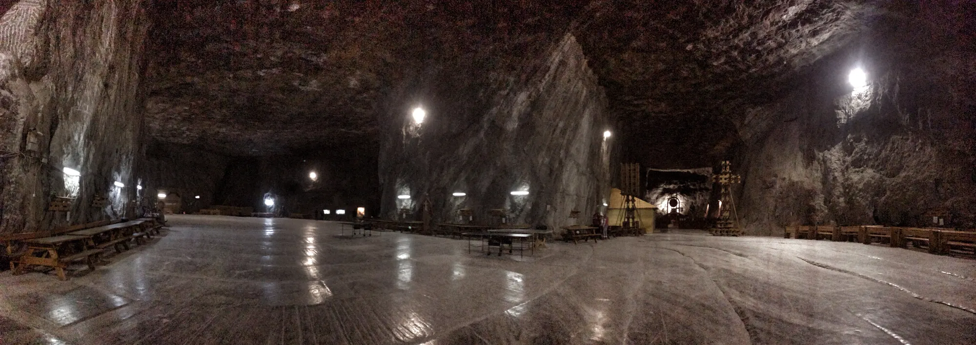
During the Miocene, connections between the Central Paratethys and the ocean changed, along with its salinity. Evaporite deposits, including salt, record part of this history. Báldi and colleagues’ 2017 paper discusses the Badenian Salinity Crisis around 13.8 million years ago and lists salt deposits in the Transylvanian Basin.

Salt deposited then was subsequently buried and deformed. A mine gallery is a human excavation through a much older rock. Neither the entrance elevation nor the mine ceiling represents Miocene sea level. Reconstructing that shore requires separate palaeogeographic evidence, explored in the dedicated Paratethys project.

Grey salt walls and ceiling with folded bands
Praid mine walls expose Miocene salt deformed later. Photograph: Octav Druta, Wikimedia Commons, CC BY-SA 3.0. Commons · CC BY-SA 3.0

Báldi et al. (2017), Discovery of the Badenian evaporites inside the Carpathian Arc

Paratethys on published reconstructions ↗

The human from Oase lived before Retezat’s glaciers retreated

A jawbone and a moraine boulder measure different things.

The 2015 genomic analysis of Oase 1, a human jawbone from a cave in southwestern Romania, estimated 6–9% Neanderthal ancestry. The length of the DNA segments indicated a Neanderthal ancestor four to six generations earlier. This is a conclusion about one individual, rather than an observed meeting in a particular valley or a statement about every regional population.

In Pietrele Valley in the Retezat Mountains, beryllium-10 dating of moraine boulders tracked exposure after ice retreat. The 2007 study places retreat from the studied maximum position at around 17,000–16,000 years ago. Putting these places together reveals how much time the phrase “the Ice Age” compresses. It does not establish occupation of the cave at the last glacial maximum.

Fu et al. (2015), An early modern human from Romania with a recent Neanderthal ancestor · Reuther et al. (2007), Late Pleistocene glacial chronology of the Pietrele Valley · Urdea et al. (2022), The Romanian Carpathians: glacial landforms prior to the Last Glacial Maximum

What the Oase human’s DNA reveals ↗

Fortresses and gold have histories that meet, but do not coincide

Sarmizegetusa Regia was Dacian. Much of the mining evidence at Roșia Montană concerns the Roman world.

The UNESCO group contains six fortresses: Sarmizegetusa Regia, Costești-Cetățuie, Costești-Blidaru, Luncani-Piatra Roșie, Bănița and Căpâlna. They are distinct places with their own positions and structures. Showing them on present relief allows comparison, but a line drawn between them does not reconstruct a Dacian road.

At Roșia Montană in the Apuseni Mountains, UNESCO describes a Roman gold-mining complex developed during the second and third centuries CE. Galleries and surviving documents support a specific history of mining. They do not automatically establish continuous exploitation since prehistory or a single explanation for the conquest of Dacia. At Sarmizegetusa, the function of an object called a “sun” likewise requires separate evidence.

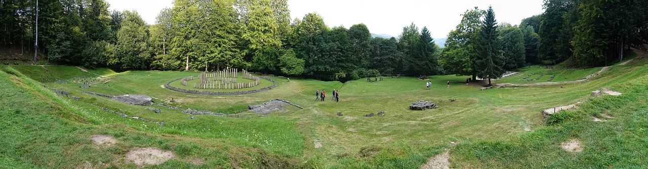
Sarmizegetusa Regia sanctuaries in a clearing surrounded by forest
Sarmizegetusa Regia’s sanctuary area in today’s landscape. Photograph: Miehs, Wikimedia Commons, CC BY-SA 3.0 ro; resized. Commons · CC BY-SA 3.0 ro

Muzeul Național de Istorie a Transilvaniei — Cetățile dacice · UNESCO — Roșia Montană Mining Landscape

The sanctuaries and the calendar hypothesis ↗

What continues beneath the forests and the crust?

A crater, a mud cone and an earthquake source are different phenomena.

Ciomadul, in Romania’s Eastern Carpathians, is a volcano whose last eruptions are dated to around 30,000 years ago. At Berca, gas from a hydrocarbon reservoir drives water and clay upward, building the small mud cones described by UNESCO. Similar shapes do not imply the same process or the presence of lava.

Beneath Vrancea, Romania’s earth-physics institute documents earthquakes at intermediate depths, about 60–200 km. In the Cerna Valley, UNESCO-listed beech forests provide evidence about ecosystems and conservation. Their status does not establish the entire Carpathian arc as “Europe’s last untouched forest”. Each place preserves part of the story; the map brings them together without assigning them the same age.

Karátson et al. (2016), The latest explosive eruptions of Ciomadul · UNESCO — Buzău Land Global Geopark · INCDFP — Source parameters of Vrancea subcrustal earthquakes · UNESCO/IUCN — Domogled–Valea Cernei component cluster, fig. 11

Why earthquakes occur beneath Vrancea ↗
Evidence, place by place

The 18 places

An editorial selection, not a complete inventory. Each record states what the place establishes and what cannot be inferred. Locations are rounded; these are not access directions.

18 / 18

The dinosaur island

Hațeg Basin

Late Cretaceous fossils

Continental sediments preserve dinosaurs from an island world about 70 million years ago. The marker represents the basin, across which finds are scattered.

Sea and salt

Turda salt mine

Miocene salt

The salt deposit records evaporation in the Central Paratethys. Today’s mine exposes the rock; its galleries were shaped by mining.

Sea and salt

Slănic Prahova

Miocene salt and tuff

The Slănic succession places salt deposition in the Miocene history of the basin in front of the Carpathians. The marker indicates the town.

People and glaciers

Peștera cu Oase

Oase 1: about 37,000–42,000 years

Fu and colleagues’ 2015 DNA analysis estimated 6–9% Neanderthal ancestry and a Neanderthal ancestor four to six generations earlier. A regional marker, without access directions.

People and glaciers

Pietrele Valley, Retezat

Moraines dated with beryllium-10

Moraine boulders record exposure to cosmic radiation. The 2007 study places retreat from the studied maximum position at around 17,000–16,000 years ago.

People and glaciers

Făgăraș Mountains

Glacial landforms

High cirques and valleys belong to the glacial landscape of the Southern Carpathians. The point represents a massif, not a reconstructed glacier outline.

People and glaciers

Rodna Mountains

Moraines predating the glacial maximum

In Pietroasa Valley, exposure ages discussed in the 2022 synthesis also indicate a glacial phase before the last glacial maximum. Ice histories differ between valleys.

Fortresses and mines

Sarmizegetusa Regia

Dacian mountain capital

Terraces, sanctuaries and fortification belong to the Dacian political and religious centre. The popular name “andesite sun” does not establish a calendar function.

Fortresses and mines

Costești-Cetățuie

Dacian fortress

One of the six fortresses in the UNESCO Orăștie Mountains group. The marker locates the fortress, not the extent of any territory it controlled.

Fortresses and mines

Costești-Blidaru

Dacian fortress

A separate fortification from Costești-Cetățuie, included in the same UNESCO group. Their geographical proximity does not make them one site.

Fortresses and mines

Luncani-Piatra Roșie

Dacian fortress

Piatra Roșie is one of the six UNESCO components. The point locates the surviving remains in today’s landscape.

Fortresses and mines

Bănița

Dacian fortress

The fortress on the rocky height at Bănița belongs to the UNESCO group. This is an archaeologically documented location, not a reconstruction of the whole fortress.

Fortresses and mines

Căpâlna

Dacian fortress

A UNESCO component north of the Costești group. This selection includes all six inscribed fortresses, not every known Dacian fortification.

Fortresses and mines

Roșia Montană

Roman mining, 2nd–3rd centuries CE

UNESCO documents a Roman gold-mining complex, with galleries and wax tablets. Roman evidence alone does not establish continuous mining since the Bronze Age.

The mountains today

Ciomadul and Lake Sfânta Ana

Last eruptions: about 30,000 years ago

The lake occupies a crater of Ciomadul volcano. The 2016 study’s estimate of about 29,600 years dates the last eruption; it is not a forecast of activity.

The mountains today

Berca mud volcanoes

Gas, water and clay

Gas from a hydrocarbon reservoir drives material upward, building mud cones. Their shape resembles a volcano, while the process does not involve lava.

The mountains today

Domogled–Valea Cernei

UNESCO-listed beech forests

Components here belong to a European forest property spanning several countries. The marker represents the Domogled area; it does not imply that every surrounding forest is untouched.

The mountains today

Vrancea seismic zone

Intermediate-depth earthquakes

Romania’s earth-physics institute describes concentrated subcrustal seismicity at about 60–200 km depth. The surface marker represents a region, not one earthquake’s epicentre.

Sources and limits

The map uses NOAA’s ETOPO 2022 relief at 15 arc-seconds, retained in the local historical atlas. The elevation grid used by the profile has 45-arc-second cells, approximately one kilometre. Relief colours represent present elevation, not rock age.

One projection, with longitude corrected at 46° latitude, aligns relief, Romania’s boundary, rivers and points. The present boundary comes from geoBoundaries, rivers from Natural Earth, and towns from the atlas’s GeoNames database. Names and coordinates may differ slightly from visitor entrances.

The section samples 321 positions along the chosen segment. Length and site proximity are calculated on a local plane in kilometres, corrected at the segment’s mean latitude. Rounded results support regional comparisons. The line is not a hiking route or an access road.

The five periods are editorial windows, not equal intervals or simultaneous views of an entire landscape. Bones have dates, salt is assigned to a geological period, fortresses are documented archaeologically, and forests have a heritage status. These kinds of evidence are not interchangeable.

The 18 locations were selected to bring these histories together, including all six UNESCO-listed Dacian fortresses. A section with no nearby points indicates a gap in this selection, not a landscape without history. The map does not reconstruct ancient shores, glacier margins or past elevations.

Romania through time: another way into the geological archive · Towns on the ancient globe

  1. Hațeg Country UNESCO Global Geopark
  2. Csiki-Sava et al. (2015), Island life in the Cretaceous
  3. Báldi et al. (2017), Discovery of the Badenian evaporites inside the Carpathian Arc
  4. Bojar et al. (2018), Miocene Slănic Tuff and the Badenian Salinity Crisis
  5. Fu et al. (2015), An early modern human from Romania with a recent Neanderthal ancestor
  6. Reuther et al. (2007), Late Pleistocene glacial chronology of the Pietrele Valley
  7. Urdea et al. (2022), The Romanian Carpathians: glacial landforms prior to the Last Glacial Maximum
  8. UNESCO — Dacian Fortresses of the Orăștie Mountains
  9. Muzeul Național de Istorie a Transilvaniei — Cetățile dacice
  10. UNESCO — Roșia Montană Mining Landscape
  11. Karátson et al. (2016), The latest explosive eruptions of Ciomadul
  12. UNESCO — Buzău Land Global Geopark
  13. UNESCO — Ancient and Primeval Beech Forests of the Carpathians and Other Regions of Europe
  14. UNESCO/IUCN — Domogled–Valea Cernei component cluster, fig. 11
  15. INCDFP — Source parameters of Vrancea subcrustal earthquakes
  16. NOAA NCEI — ETOPO 2022, 15 arc-second global relief
  17. geoBoundaries — Romania ADM0, CC BY 4.0
  18. Natural Earth 1:10m rivers, public domain
  19. GeoNames — Romania geographical database, CC BY 4.0